
| This area shows aerobatic and stunt flying, as well as other unique experiences with aviation. I am not an airplane pilot, but enjoy flying and aviation, and I am an avid skydiver and canopy pilot. Many pilots are willing to take you up with them. This page shows some commercial aviation pictures such as views of interesting features from above, as well as some pictures of fun flights in aerobatic aircraft or while taking some flying lessons / training over the years. Note - This page may take a while to load on some SLOWER connections! |
ToolTally.com offers tool reviews for the active, hands-on individual.
| Are you enthralled by fantastic aerial views? Grand Canyon skywalk is the perfect location to take in breath-taking sights! Grand Canyon helicopter tours is the best way to go for your next vacation. Everyone can see the grand canyon from the ground; get a bird's eye view! Make sure you bring your camera - the grand canyon air tour is an event you will want to remember! |
Note: I have put together a special section on aircraft flight basics, engines, propulsion systems, and some basic physics involving flight principles. This section may be of good value to students, pilots, and anyone interested in aviation. To go to this section, please click the link provided above.
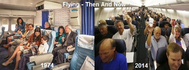
The days where flying on a commercial airliner was limited to the rich and exclusive people are long gone ... Along with the flair, perks, elegance, and service of years past. Less than a half, or even a quarter, of a century ago - Both flight attendants (or "Stewardesses" as they were called back in the day who were mostly women) and passengers alike would dress up to fly in flashy and classy outfits. We were dealt exclusive service, drinks and food were free, and you can pack as many bags as you could lug to the airport. Nowadays, flying on an airliner is just like hopping on an expensive city bus, with people in their everyday clothes, in a manner no more routine than being charged for bags, an in-flight "meal" being chips, and being crammed into a metal pressure vessel where the in-flight movie is played out on smart phones and laptops. Flying has come a long way in the past 50 years in many ways.
I can go on and on talking about aircraft and how they changed over the years. Airliners started out as piston-driven propeller powered planes, such as the Douglass DC-3, Ford Tri-Motor, and eventually the more luxurious 4-engined airliners as the Super Connie. During the 1940's and 50's, a trip from Los Angeles to Miami would take 8 to 10 hours for the privileged people who had that option. In the 1950's and 60's, the jet planes came, where the same trip across country would take about 5 hours. Then came the SST (such as the Concorde), which remained affordable only to the rich until its retirement in the late 1990's. Since then, aircraft mostly focused more on fuel efficiency and passenger volume than speed. For a while we had the tri-jet planes, such as the Boeing 727, DC-10, and L10-11 TriStar up until about year 2000. Now the main airliners are twin-jets, such as the ultimately successful Boeing 737 and long-haul airliners such as the Boeing 747 and new Airbus 380.
In these earlier "hey days" of commercial aviation, fuel costs were not an issue, but planes then consumed much more fuel than those today, and engines were not as efficient, nor as reliable. Accidents, hi-jacking, and terrorist acts would happen from time to time around the world, most notably the September 11, 2001 attacks. Still, with equipment and security improvements, flying is SAFER now than it ever was. Back in the day, you would get a gourmet meal and never thought twice before ringing the flight attendant call button! Service simply CAME with your airline ticket. Flying was more of a privilege in those days, and was something both special and a symbol of one's success.
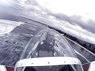
Now you are probably wondering what the heck my term "Fly-Train" means? Well, this goes back to the first time I ever flew on a commercial airliner, which was a flight from New York (Kennedy Airport) to Miami, Florida for vacation in February 1977 aboard a Douglass DC-10. This trip, and flight, was both a life changing event, as well as a downright terrifying ordeal leading up to the trip. I will explain that later. Before that, the first time I ever flew in any aircraft was over Niagara Falls, Canada on a Bell-47 helicopter tour in the early 70's - Ironically at the same air tour group shown farther down on this page many years later. I was only 4 years old, and I was quite un-nerved by the rather "rough" and loud environment of the "bubble" cockpit, while peering down a thousand feet or so at the raging water below us.
As a child, that "feeling" of nothingness and vertigo was a feeling I hated with a passion. I hated roller coasters (YES, that was ME when I was young), and during a trip to an amusement park I would just stand and "watch", or ride the kiddie rides or carousel. Upside down rides or things that spun fast were OFF limits. While planning our Florida trip in 1977, my family initially was going to drive down, this takes about two days. I was impatient as any 7 year old would be with the incessant "are we there yet" complaining during even shorter road trips. I suggested why don't we fly down, with a little over 2 hours to Florida, better than two DAYS? My parents said "No we drive, flying is expensive" ... But I insisted. To quiet me down, they used a scare tactic, saying flying is JUST LIKE those rides I hate so much at amusement parks, and you get that "lose your stomach" feeling because you're going really fast. Immediately I shut up and looked forward to the 2 day car trip!
A few weeks before leaving, my parents got a good deal on a flight to Florida and called me in to tell me the delightful news. My dad told me we were flying and not driving, and the FIRST thing I thought about was the "sickening" feeling you get when you take off, and that is what they put in my head so I would be initially discouraged into driving. I was scared. I didn't want to fly and get that "feeling". I was crying and my parents promised me that you DON'T get sick to the stomach on a plane like on a scary thrill ride. I now had a phobia - Aerophobia, or fear of flying - Burned into my head. This stemmed from Kinetophobia (fear of motion or uncontrollable accelerations) ... But I was too young to understand that you won't feel anything going 550 MPH - You feel the change in speed, not the speed itself. But I was only 7, and it would be at least another 10 years before I even know what physics is.
My parents then came up with a unique way to calm my fears. They told me that they cancelled the flights and instead will be going on a high-speed train called the "Fly-Train". This was simply a very fast train that leaves from the airport, and makes it to Florida in less than a day. The inside of this bullet train will look just like an airplane, same seat arrangements, windows, even the jet bridge "tunnel" entrance to it ... Clever, huh? So I trusted them, and my dad would joke with me with his arms out making a whooshing noise just to be cute. I was to the point that I would get mad at airline commercials on TV - Sometimes spitting at it! Finally winter break in mid February 1977 arrived. It was a cold and clear morning, and we met with another party who was joining us on the trip and worked with my dad on the police force (he was still NYPD at the time). We dropped off my autistic brother at my grandparent's place (he did not come with us) and headed to the airport. I still believed I was riding the "Fly-Train"!
So there we were I, my parents, and their friends sitting on this so called "Fly-Train". The stewardess began the announcements, and revealed the gut-wrenching truth on what kind of "vehicle" I was REALLY sitting in: "Ladies and gentlemen we will go over the safety features of this DC-10 AIRPLANE and we will be cruising at 35,000 feet." I had an anxiety attack. I wanted to get up and leave. I couldn't. I had to deal with it. I turned white and was shaking. My hands were clenched. I was scared - and also MAD (for my parents lying to me). I was sitting in the middle seats (the DC-10 coach class is 2-4-2 seating with 2 aisles wide body) and wanted nothing to do with the window. With my mouth so dry I couldn't even talk, the plane taxied to the threshold, spooled up all three of its CF6 engines, and powered its way into the cold blue sky over Jamaica Bay (by Kennedy Airport in New York) and out over the Atlantic Ocean. I was going to Florida in 2 and half hours, like it or not.
I remember the feeling of being pushed back into my seat, no more than accelerating quickly in a car - Just longer lasting. The nose of the plane pitching up and the "room" I was in getting tilted likewise. I looked around and saw everyone calm, my mom was holding my hand ... Or - More likely - I was digging my fingernails into her hand. I saw a glimpse out the left window across the aisle and seats and saw the wingtip and the beacon on it flashing - Then a deck of clouds whizzing by it. I was waiting for that sickening "stomach" feeling but it never came. I was like: "Is that it? Were up?" ... My parents said: "Yes we are climbing and airborne" ... As I eased the "death grip" I had on my mother's numbing hand. I switched my seat back to the window seat I so much refused earlier. I looked out at the clouds far below, and the Earth and blue ocean with ships crisscrossing paths. I became glued to the window, the dark blue sky, the way the sun and clouds looked ... Just clear and more beautiful. It was smooth and there was absolutely no sensation that we were doing nearly a mile every 6 to 8 seconds.
I remember starting the descent and making the turn towards land and how much greener and lush Florida looked. I thought turning in a plane was amazing, due to the banking, and never could wrap my mind around WHY it did not feel like you were tipping over - Remember I was only 7 years old. We came into Miami International Airport and landed. No bad feelings, no sick stomach, just a 7 year old kid who just ended a gut-wrenching, senseless month of aerophobia in a delightful and life changing way. I remember speaking with the flight attendants and the pilots, one sat me right in the captain's chair, and showed me the controls. It was like seeing the inside of a "spaceship", all the gadgets surrounding the captain, first officer, and flight engineer's stations, a joyful moment for any young pre-teen. The last thing I said as I stepped back onto the jet way bridge was "Thank God for the Wright Brothers". My fear of flying would turn into a passion and many years later a long career in skydiving.
|
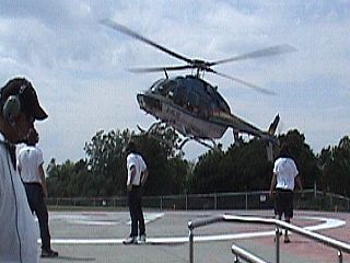
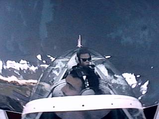
Niagara falls helicopter tours is an elite aviation tour company offering scenic tours high over the Niagara River Gorge and by far the best views of the falls and rapids below. They fly a fleet of Bell-Textron 407 helicopters, including the one coming in to the landing pad in this picture. |
|
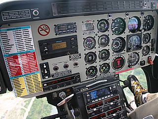
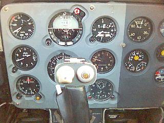
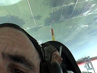
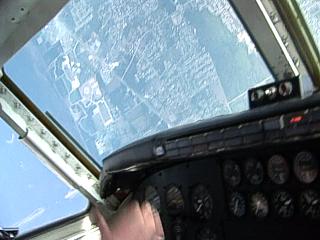
Here is a view of the cockpit of the Bell 407 helicopter used by Niagara helicopter tours. Full turbine intrumentation plus an aviaonics package for communication and navigation (lower part of console). An audio patch to the intercom is provided by the device to the left just below the "non-smoking" symbol. This provides a narration for the tour, as the pilot (to the right) flies the aircraft at a set vector / course so that the audio program is "synchonized" to what we see below. The vectors to fly are provided by the navigation computer at the bottom of the instrument cluster. |
|
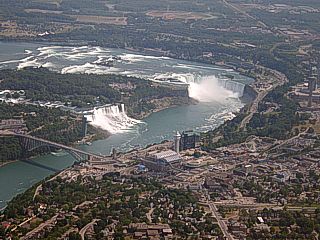
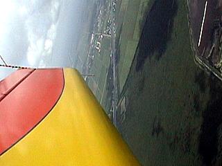
Here is a wide-angle view of the Niagara Falls area looking to the south from an altitude of about 3,000 feet AGL. Rainbow bridge, connecting New York in the USA (left) and Canada (right) is to the lower left. Following the river up-stream leads to the American Falls and ultimately Horseshoe Falls. Note the violent rapids up-stream of Horseshoe Falls. The city of Niagara Falls (Ontario) is in the foreground with a major tourist / convention center just off Canadian customs on the Canadian side. Just right of that is a large ferris wheel. The casino strip and Skylon Tower is to the extreme right side and half-way up the picture. |
|
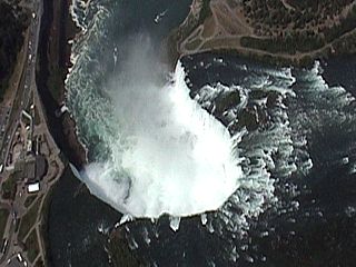
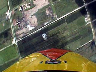
While in a steep turn, you are able to shoot pictures / video straight down. In this picture, the Horseshoe Falls is about 3,000 feet below us and presents this spectacular view. Goat Island (New York) is to the upper right and Canada is to the left. The "nudge" in the canyon wall to the left near the edge of Horseshoe Falls is called Table Rock and is jammed with tourists from all over the world. |
|
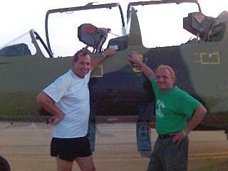
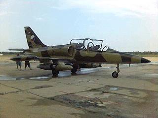
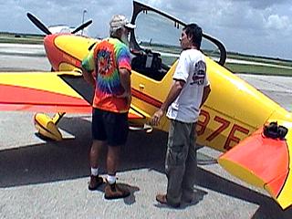
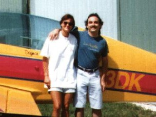
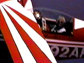
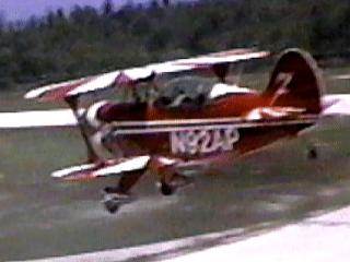
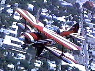
Here is a picture of L-39 trainer pilot Don Kirlin (left) and myself (right) standing in front of his L-30 "Albatross" fighter trainer at hangar 2 in Rantoul, Illinois. Don was my trainer pilot who took me up in this fighter jet trainer. Don was giving rides in this aircraft at the World Free Fall Convention event, where anyone, for a large payment, could ride this beautiful classic warbird. Procedes from anyone paying to ride were generously donated to charity, after fuel costs. |
|
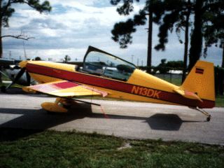
This is the L-39 "Albatross" fighter jet trainer. There is a front and back seat, the trainer (or so called "safety") pilot flies the plane from the front seat and the trainee (or passenger) rides in the back. The plane is dual control, and can be flown from both positions. The seat is an armed ejection seat (so don't touch anything if you are riding in this bird)! It is a 7,340 pound Czech-Republic built fighter powered by a turbojet engine that produces 3,792 pounds of thrust. It is subsonic, with a maximum level speed of about 420 Knots and a ceiling just over 37,000 feet. G forces range from about -3 to +8 G's. |
|
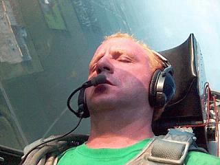
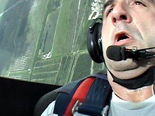
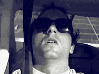
Here is a picture of myself, barely conscious during a hard 6-7 G turn in flight in the L-39. Note the effect of the high G forces (no, not my sunburned pink face and blonde hair) as I am pushed down into the ejection seat. Note the horizon during the high bank angle. |
|
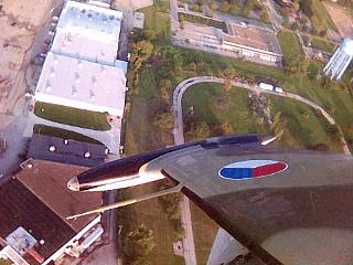
This is a picture while looking out the left side of the cockpit during a high-G turn to the left. The wing and wing-tip fuel tank are pointed towards the ground during the high bank angle. |
|
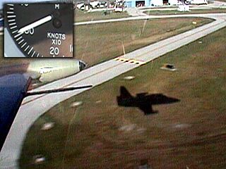
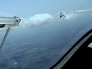
Here is another picture looking out the front of the L-39 cockpit over Don Kirnin's head, who is piloting the aircraft from the front seat. Here we are not landing, but doing a 325-Knot close approach (fly-by) past the World Free Fall Convention. These still pictures do NOT do any justice to the experience, but trust me, the ground was a blur! This attacted a large crowd after a few of these fly-by's. |
|
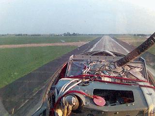
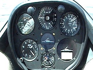
This is a view of the flight instrument panel of the L-39 while in flight at 300 Knots level at roughly 1,700 feet. Not much different than any aircraft instruments, except for most of the labels and controls were in Czechaslovakian. The three top instruments (from the left) are the most important: Airspeed, Attitude, and vertical speed. On each side of the cockpit, were many switches and indicators (not shown in this picture) as well as both the control stick and ejection seat handles (I never touched that one) between my legs. |
|
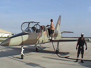
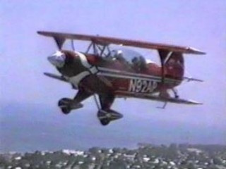
Here is another L-39 at Airglades Airport in Clewiston, Florida during the "Everglades Skydiving Boogie" event in late January 2008. Tony is the pilot refueling this famous Czech warbird. Just under 200 gallons of Jet-A is being pumped into this aircraft prior to two flights (including mine), which last about 30 minutes each. This will be my second flight aboard one of these fighter jets. |
|
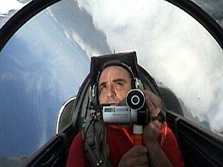
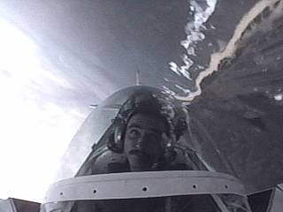
On this flight, I used the same small video camera (Sony DCR-HC28) I use to film POV footage on roller-coasters, with a custom mono-pod grip handle. The footage obtained was very interesting, coupled with a separate audio feed from a tape recorder in a zipped-pocket and small mike inside the headset. The video camcorder has a wide-angle lens (0.45) and is shooting through a wide-angle mirror in the rear cockpit where I was sitting. The aircraft is about 135 degrees through an aileron roll in a steep climb above a cloud deck in this picture. |
|
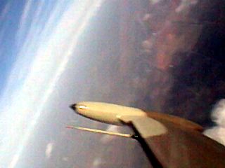
Pulling up into the vertical, the ground (and clouds) drop-away in this self-portrait shot of myself. Note the fixed-geometry jet intake to the right. |
|
Here is another view, this one to the side, during a steep zoom-climb (level flight at nearly 300-knots then pulling straight up into a vertical attitude). The right wing and reserve fuel "tip tank" can be seen along with a "reverse ground rush" (dropping away effect). This maneuver caused a 5,000 foot+ gain in altitude in about 15 seconds. |
|
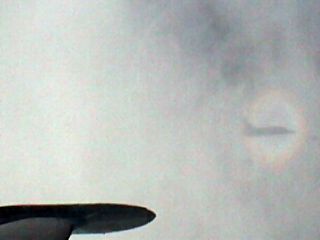
Passing and "busting through" clouds at 250-300 knots produces the sheer sensation of speed, especially as the shadow of the plane races across the cloud tops and sides with a halo-effect called a "pilots glory" (to the right side of the photo). This day was a beautiful day for flying, especially with these white and puffy (cumulus) clouds in the late afternoon. The L-39 just finished pulling out of a steep dive and is back to about 275-knots level flight. |
|
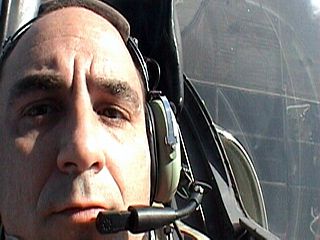
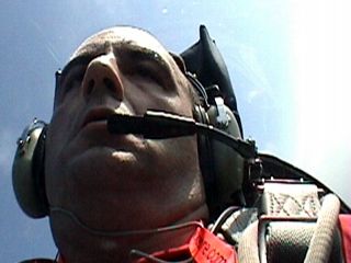
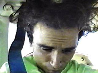
Here is a view of myself during a steep 5-6 G turn. G effects are insidious in fighter jet aircraft because they remain in place for longer periods of time (higher speeds in jet = exponentially longer time to complete a turn). Huffing and puffing (flexing my legs and thighs) reduces the danger of grey / black out. Still, the G-effects can be seen on my facial skin. |
|
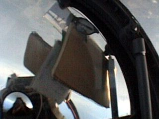
In any aerobatic aircraft, zero G (weightless) and even negative G can be experienced. This picture was taken during an inverted parabolic roll while the plane was in a near inverted attitude. The objects (sunglasses, pilot's log-book, etc) not stowed "float" up to the canopy! |
|
Here is a picture of a "low approach" across Airglades Airport at over 300-knots (see inset to the upper-left, taken before the main picture). Total speed was about 320-knots (almost 370 MPH) at just 15 feet above the ground. We did a lot of extreme low-level flight, sometimes as low as 15 - 20 feet above the "deck" (ground), buzzing by tree-tops, and coming within feet of birds! The L-39 can go even faster, but the FAA would not allow it! |
|
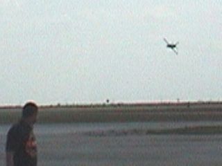
Here is a view from the ground during the same "low approach" maneuver. The L-39 jet "buzzes" the airfield at over 300-knots giving people and spectators there a load doppler effect. After the low pass, the plane has enough kinetic energy to pull a hard "break" (turn) to the right and climb back up to 3,000 to 4,000 feet in seconds. |
|
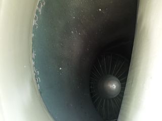
Here is a view into the fixed-geometry jet intake of the L-39 "Albatross" before climbing into the cockpit of the jet for a demo flight in Clewiston in January 2009. The jet engine is a twin-spool low bypass turbofan engine (Ivchenko AI-25) that develops about 3,800 pounds of thrust. Intakes on each side of the aft fusalage feed air to the jet engine's compressor and fan, shown in this picture, which includes the starter bullet. The engine's exhaust is below the tail of the plane. |
|
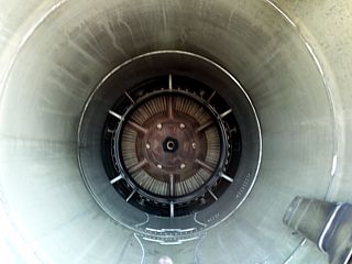
This is a view of the "business end" ... The tail-pipe of the L-39 fighter jet (taken in January 2009). The Ivchenko AI-25 engine's high velocity exhaust duct and LP turbine can be seen in this picture, and is surrouded by the smaller "bypass" air duct from the fan stage in the front of the engine. |
|
This is a view out of the left side of the L-39 (at the Everglades Skydiving Boogie in Clewiston in January 2009) while it is rounding the top of a 6,000 foot high loop (while in the inverted attitude at the top of the loop, which is an an altitude of nearly 15,000 feet MSL). G-forces during this maneuever ranged from 4-5 G's with a maximum airspeed of just over 400 Knots (indicated) while passing through 10,000 feet (over 500 MPH). The view is to the west. |
|
Here is a view out the front the L-39 (in January 2009) while doing a "river run" where we follow the course of the Saint Lucie Canal at very high speed (around 425 Knots) and at an extremely low-level flight (50 feet or so above the water)! In this picture, we are descending to do the low approach and scare the heck out of anyone fishing - Duck! |
|
Here is a view as the L-39 jet rounds the top of a loop at about 14,500 feet (in late January 2010) while south of Clewiston, Florida. The image shows the left wing tip tank (far left) and pitot probe as we are in a vertical attitude (going nearly straight up) and completing the top of the loop. The loop itself is over 6,000 feet in diameter. |
|
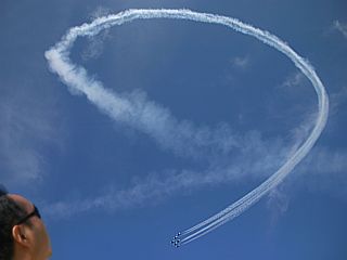
Just how BIG are these loops? Certainly bigger than the 75 foot average size of a vertical loop on a roller coaster! In fact, more like 100 times that size! In this picture, taken at an airshow in Fort Lauderdale of the Air Force's Thunderbirds demonstration team, such a vertical loop (with smoke trails) is shown to put the size of what a loop is like in a fighter jet aircraft traveling at such high speeds (about 500 MPH). Basically, this is the SAME type of loop, literally MILES in height, we executed in the L-39, just at a lower altitude as this picture is at an airshow. Vertical loops / dive pull-ups in a fighter jet impart very high G-Force accelerations (often over 5 G) on the occupants of the aircraft as well as involve a large vertical displacement (loss / gain of altitude). |
|
Here is another view from an L-39 flight in late January 2010 flying low and in a tight left banked-turn over the Okeechobee Canal south of the Lake that straddles highway 98 while flying well over 300 Knots. |
|
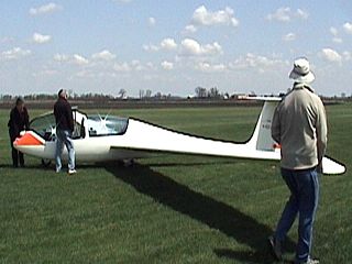
This is a German-built 2-place Burkhart Grob sailplane. This is a medium performance glider with a ratio of roughly 34:1. That means for every 34 feet it flies forward, it sinks (descends) at about 1 foot. This translates to about 1.45 knots of descent-rate while flying forward at about 56 knots. The Grob sailplane in this picture is being prepared to be towed by a Piper PA25 Pawnee. |
|
The glider (sailplane) is towed into the air in a process called an AEROTOW. A modified Piper PA25 Pawnee (agricultural) plane with a 230 HP engine tows the sailplane into the air and up to release altitude. |
|
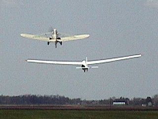
Here is a view from inside the 2-place Grob sailplane just after becoming airborne over Windy-City Soaring Club in Hinkley, Illinois. The Piper Pawnee tow-plane can also be seen to the upper right as we ascend above the grass runway. |
|
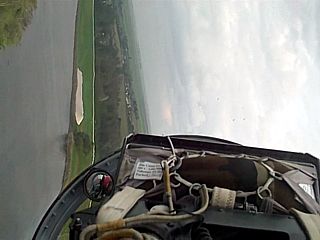
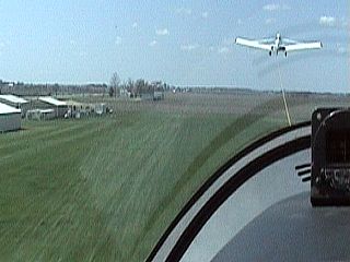
At roughly 6,000 feet MSL, or about 5,300 AGL, as Hinkley, Illinois is 700 feet above sea-level, we reach our release point. Windy-City Soaring offers 2 rides in their gliders, one with a 3,000 foot release ("Red Wing" package) and another at one mile ("mile high Eagle" package), the latter allowing more time for a bit more - and worth it. In this picture, the aerotow-line is released by a lever / knob by the pilot and the tow-plane breaks away (to the upper-left) and returns to the ground with the tow-line. We are now on our own, no engine, just gravity and thermals. |
|
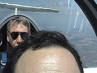
Here is the cockpit layout of the 2-place Grob sailplane. The instructor pilot is in the rear seat and I am sitting in the front (sorry about my big forehead - as we are in a small cockpit after all)! The 2-place Grob sailplane is a dual-control trainer, so anyone riding in the front seat can also take the controls and try to fly it. |
|
Here is a view out the front of the cockpit just after coming out of a steep dive and in a steep turn towards the left. These sailplanes are capeable of mild aerobatics, and the most we got up to was roughly 3-4 G's of pull during these maneuvers. Aerobatics is not the true goal of a sailplane, the main purpose is to remain aloft and find rising air to "lift" the sailplane higher and stay aloft longer. Aerobatics create a lot of (induced) drag which shortens the time aloft. The "string" across the canopy is to indicate a condition called SIDE SLIP, which also creates drag. The "string" should be centered, and is corrected by using the rudder pedals. |
|
This is a picture of the instrument cluster of the Grob sailplane in the front cockpit. It has basic information showing altitude (about 1,400 feet) and airspeed (about 70 Knots). By far the most important instrument is the one to the upper-right, called the VARIOMETOR. This display tells how much the sailplane is either rising or sinking, and differs from vertical speed in some ways. Rising air is caused by either two things, the differential surface heating of the ground causing rising air "bubbles" called THERMALS, or rising air caused by mountains, such as a mountain wave. Both produce a natural lift for the lightweight sailplane, allowing it to remain aloft for a while on "good" days. The variometor indicates the speed change which may indicate such upward (or downward) air movements. Th this case, the variometor is showing an upward rise of a little over 10 Knots, which is great. |
|
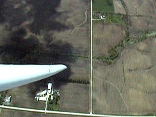
Here is the long left wing-tip pointed at the ground of the American Midwest from nearly a mile up. We are in a steep left turn and attempting to stay in a thermal to seek the rising air within it. The structure below the wing tip is a farmstead. |
|
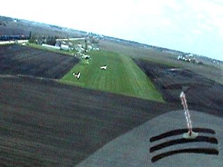
Coming in for landing after being aloft for almost an hour (good thermal flying that day), the pilot deploys the speed brakes and lines up for final approach. The runway at Windy-City Soaring Club is grass, and we are headed west into the wind for landing. The speed brakes are spoiler type extensions that are raised on the upper chords of the wings, creating drag and hastening the "sink rate". In physics, a glider is all about "energy conservation" where potential energy (height) is converted to speed (kinetic energy) since no power input occurs from any engine (except for natural input, such as thermals). |
|
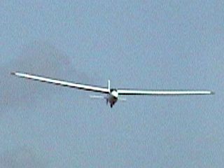
Here is another picture of another sailplane taken from the air. The long wings allow lower drag but lots of lift, which is very important for a sailplane (glider). |
|
Here is a picture of pilot Dave Woods, visiting the Skydiving "liquid-Sky" Boogie in Clewiston, FL in July 2008. He is giving instructions and rides in a 2-place (dual) Extra 200 aerobatic plane (seen in this picture). Pilot (Dave Woods) is standing to the right. The Extra 200 series is (only) a bit less poweful than the 300 series, but is fuel efficient and powered by a 220-HP Lycoming (4-cylinder) engine. The 300 series aircraft is powered by 6-cylinder 260-HP Lycoming engines. |
|
This is a picture of myself in the front (trainer) seat and pilot Dave Woods in the rear-seat. We are upside down (inverted attitude)! |
|
Looking to the left, the left wing and ground is visible while in a steep vertical attitude (diving straight-down). Speeds in the dives reach about 180-Knots (about 205 - 210 MPH). |
|
Here is a view looking straight forward out of the cockpit while in a dive (at 210 MPH through 3,000 feet). The ground is directly in front of us, and coming up (ground rush) at a rate about TWICE as fast as a skydiver would see at 120-MPH passing through 4,000 feet! |
|
I got my chance to fly the plane and was able to do some parabolic rolls. The aircraft is very responsive. In this picture, I am pushing the aircraft over forming a PARABOLIC maneuver. This produces a period of weightlessness (zero-G) that lasts for 5-10 seconds. The weightless condition is denoted by the strap from my harness, which can be seen "floating" in front of me! |
|
Here is a picture taken of myself when the aircraft was in a very high-G pull-up (about 6 G's, or higher). The "reverse ground-rush" effect is evident in the picture (especially in a video of this), and my face is clearly showing the effects of the G-Force (squinting / tunnel-vision, grey-out, "fat" face / double-chin, etc). |
|
Dagmar Kress of Flugvergnuugen Aerobatics and I standing in front of her new Extra 300L aerobatic plane back in 1996. This plane can pull over 10 G's and fly at over 220 Knots. The Extra 300 is a German-built aircraft designed to compete against Russia's Sukoii type aircraft. Once in the USA after the end of the cold-war, this plane remained at the aerobatic "pinnacle" of civilian aerobatics. |
|
A picture of an Extra 300 XL aircraft owned and flown by Dagmar Kress for Flugvergnuugen Aerobatics back in 1996. Dagmar, a native of Germany and aerobatic pilot, can take people up for training and even rides in this aircraft out of Fort Lauderdale Executive Airport in Florida. The plane is a $250,000 "toy" made up of titanium and composite materials and can pull very high g forces as descibed earlier. I experienced up to 11 G's in this plane! |
|
This picture was taken in a Pitts Special S2-B aerobatic aircraft flying over the Florida Everglades at about 5,000 feet. Quality is poor but excusable for a self portrait of myself taken while pulling hard out of a steep dive with a small 110 film camera. The pilot, Tom Teidt with Pompano Air Center, is behind me and not visible. The shot is towards the rear of the plane. Note the sun and sky behind us due to our diving attitude. Note the sagging effects on my eyes, double-chin, and "mouse mouth" as G forces reach almost 7 times the normal pull of gravity. During such high G forces, my 175 pound body weights over 1200 pounds! |
|
Flying in a Cessna 152 Aerobat, the pilot (Nick Tsokris) and I are pulling up out of a dive producing a G load of about four G's. The camera is positioned on the side of the windshield to capture my facial expression. |
|
On a Cessna Aerobat flight with pilot and friend Nick Tsokris, we decide to "experiment" with the effects of negative G-forces. In this picture, we are in a negative G "push-over" maneuver. My long hair at the time can be seen being pulled upwards and hitting the ceiling of the aircraft cockpit! We are only experiencing about a half of a negative G but the effects are obvious. |
|
A closeup of the cockpit and wing of a Pitts Special S2B aerobatic biplane over Key West, Florida. Taken from a Piper Cub flying close by, the view shows pilot Fred Cabanas, with Island Aeroplane Tours, in the rear pilot seat and myself in the front passenger seat. |
|
The Pitts Special S2B shown here performs a low approach at Key West International Airport. This picture was taken from a Piper Cub flying close to the Pitts Special. Here we are less than 20 feet off the ground and going 150 MPH. We eventually overtake the Piper Cub and rocket out of sight at 200 MPH. At the end of the runway, we pitch up at 20 feet and climb to 1,800 feet in about 10 seconds. Pilot was Fred Cabanas with Island Aeroplane Tours. |
|
A view of a Pitts Special S2B biplane a few hundered feet over Duval Street in Key West, Florida. The Pitts Special is flown out of Island Aeroplane Tours and is piloted by Fred Cabanas. The picture was taken from a Piper Cub flying in close formation with the Pitts Special. |
|
Flying over Key West, Florida in a Pitts S2B aerobatic biplane. Based out of Island Aeroplane Tours in Key West International Airport, Pilot Fred Cabanas will turn the island of Key West upside down! |
|
Here is a picture taken from an in-flight cockpit video camera on pilot Chris Mckinley's Pitts S2B based at Tsunami Aviation at Dillingham Airfield in Oahu, Hawaii. In this picture, we are in inverted (upside-down) flight. Note the beach front, ocean, and airfield runway in the upper portion of the video frame! |
|
Got a need for some speed? Do a low approach! In this picture, taken from an observer standing next to the runway at Dillingham Airfield in Hawaii, Pilot Chris Mckinley and I are executing the low approach maneuver at near 200 MPH less than 20 feet above the ground. A low approach is simply descending the aircraft to very low level (less than 100 feet) and fast (over100 MPH) and subsequently pulling up. Note that the smoke is on in this picture for a really cool effect. |
|
Here is another low approach over the ocean surf zone near Dillingham Airfield in Hawaii. Here we are flying at 185 MPH at an altitude of no more than 20 feet, treating some surfers to a startling, loud, high-speed "Doppler effect". Low approaches like this are dangerous. Besides risks of hitting birds, such as sea gulls or pelicans, they require slight of stick and rudder that only trained aerobatic pilots like Chris Mckinley of Tsunami Aviation can treat you to! |
|
This video frame grab shows Chris Mckinley with Tsunami Aviation (Dillingham Airfield, Hawaii) in the rear-seat flying, and myself in the front while in the straight-up vertical attitude of a hammerhead stall. The ocean (note the reef colors beyond the surf-line) is behind us. The aircraft is beginning to pitch-over to the right, thus completing the "hammer-head" effect. The "hammerhead" maneuver is done by bringing the plane to a vertical line (straight up) and bringing back the engine power. Once a "halt" is reached in the vertical climb, a rudder pedal is applied to initiate the pitch-over and stall (loss of aircraft wing lift). The nose then drops, and the plane returns down along the same vertical line it previously climbed on as engine power is applied. When sufficient airspeed is built up, the plane then pulls out of the dive to normal flight. Note: Chris Mckinley was killed doing what he enjoyed the most later in the year of 1994 in the same aircraft during a performance where the Pitts Special impacted the Pacific Ocean. |
|
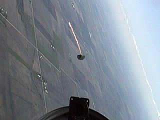
This is a picture looking out the FRONT of a Beechcraft king Air over Titusville, Florida. The plane has just dropped skydivers on an intermediate altitude skydive from 18,500 feet and is in a steep dive. In such a vertical attitude (plane literally going straight down) only the ground and neighboring indian River can be seen out the front of the aircraft! After diving about 2000 feet, the plane leveled somewhat (still diving but not as steep) going well over 300 MPH (true airspeed) at about 3.5 G's (I nearly passed out)! |
|
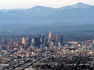
Here is a picture of a section of downtown Los Angeles, California while on final approach from roughly 2,000 feet in a Boeing 737 on a flight from Chicago to Los Angeles in August 2015. |
|
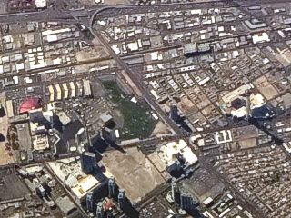
Looking nearly straight down from around 38,000 feet, a section of the Las Vegas strip in Nevada can be seen in the desert below. The flight was on a Boeing 737 flying from Los Angeles to Chicago in August 2015. If you look closely to the middle-right side of the picture, you can see the 1,149 foot "Stratosphere" tower (casting a shadow) and hotel. |
|
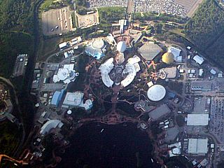
This is a picture of Disney's EPCOT Center and World Showcase south of Orlando, Florida from a commercial airliner flying out of Orlando, Florida at an altitude of about 12,000 feet. The large "golf ball" in the upper-center part of the image is the Spaceship Earth geosphere. Various attractions such as Mission Space and Imaginations surround the geosphere. The World Showcase is towards the lower portion of the picture. |
|
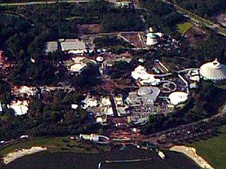
Here is a picture of Walt Disney World south of Orlando, Florida from a commercial airliner flying out of Orlando, Florida at an altitude of about 12,000 feet. The fampous castle is in the center of the picture. Tomorrowland and space mountain is the large cone-shaped structure to the far right. |
|
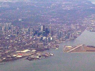
This is a picture of the city of Toronto, Canada (Ontario province) that straddles the north side of Lake Ontario. The picture was taken from an altitude of about 11,000 feet on a Boeing 737 commerical airliner flying into Pearson International Airport from Miami, Florida. The tall tower-structure in the center of the picture is the CN Tower, a major landmark of the city's skyline, as well as one of the tallest free-standing structures in the world (about 1,800 feet high). To the lower right is Toronto's City Centre Airport, a small airfield on Toronto Island south of the city. |
|
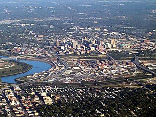
Here is a picture of Kansas City, Missouri while on final approach into Kansas City Airport in a Boeing 737 at an altitude of about 3,000 feet. The city is divided by the Missouri River to the left and most of its major buildings sit on a hill top in Missouri, with its western sections in the state of Kansas. |
|
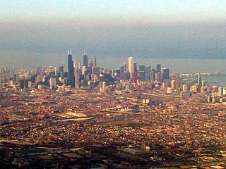
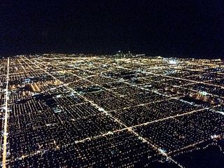
Here is a picture of downtown Chicago, Illinois and surrounding urban areas / Lake Michigan. This picture was taken from a Boeing 737 departing Chicago's Midway Field, and at an altitude of roughly 3,000 feet. |
|
Here is a picture of the New Orleans, Louisiana area taken from a Boeing 757 flying from Fort Lauderdale, Florida to Houston, Texas at about 34,000 feet. The view is a far-shot but a few things can be seen. The bridge across Lake Ponchatrain is the "line" to the upper-left. Downtown New Orleans, with its skyscrapers, and super-dome just to the left of the sky-scrapers, is mid-way down the picture and to the right side. This is the same area ravaged by the western side of hurricane Katrina in 2005. The Mississippi river also runs in the center of the picture from left to right. Salt marshes appear at the lower portion of the picture. |
|
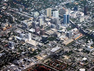
This is downtown Fort Lauderdale, Florida viewed from a Boeing 717 commericial airliner flying at an altitude of roughly 5,000 feet. The flight pattern was an approach from the west and flying out over the ocean before a final approach from the east landing at Fort Lauderdale Airports runway "9 Right". During the base pattern, the flight path takes us pretty much parallel to Sunrise Blvd and north of downtown over Wilton Maners, offering this fantastic view of Fort Lauderdale of the right side of the aircraft. |
|
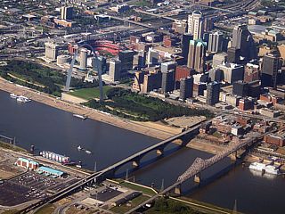
Here is a picture of the majestic skyline of downtown Saint Louis, Missouri from the northeast over Illinois an altitude of about 4,500 feet while on approach to Lambert International Airport in an MD-80 commercial airliner. The Jefferson memorial path and the 660 foot-high Archway monument (upper-left of center) cannot be missed in this morning picture! The large river is the Mississippi river separating Illinois (lower-left) and Missouri (to the upper-right). |
|
This is a picture of downtown Jacksonville, Florida taken from a CRJ-700 flying at an altitude of about 37,000 feet. The view is looking down but to the west. Highway 90 and interstates 95 cross the Saint Johns river and this is also the start of Interstate 10, which is a cross-country highway that runs all the way into California. At least 3 major bridges can be seen in this picture. |
|
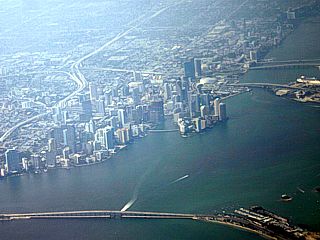
Here is a picture of downtown Miami, Florida and the surrounding Biscayne Bay from a Boeing 757 commercial airliner departing Miami International Airport enroute to San Francisco. This picture shows downtown from an altitude of about 10,000 feet. |
|
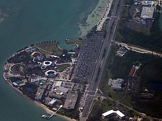
This is the Miami Seaquarium near Dinner Key / Key Biscayne at the end of the Rickenbacher Causeway to the southeas tof downtown Miami, Florida. This picture was taken from a Boeing 757 commercial airliner from an altitude of about 10,000 feet on a flight from Miami to san Franciso. |
|
This is downtown Orlando, Florida taken from a CRJ-700 (Canadair Regional Jet) flying at an altitude of about 37,000 feet. The two major highways are Interstate 4 (running left to right on the top of the picture) and highway 408 (running along the left side). The view is to the southwest but looking nearly straight down and zoomed in on the buildings. Disneyworld, a popular attraction, is not near downtown Orlando as most might think. It is near Kissimmee, about 15 miles to the south and southwest of downtown. Lake Eola is the round lake in the center of the city (just below the center of this picture). |
|
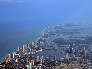
This is a picture of Miami beach, Houliver, Bal Harbour, and Hallandale along the east coast of South Florida in Miami-Dade county. The view is to the south, and shows an extensive collection of high-rise condominiums as well as many other high-income waterfront homes and hotels. Miami Beach, including South Beach, extends from the center of the picture (Houliver inlet and park) to the upper-right. This picture was taken on an MD-80 commercial aircraft at about 4,000 feet while on a weather hold-pattern before being cleared to land at Fort Lauderdale Airport. |
|
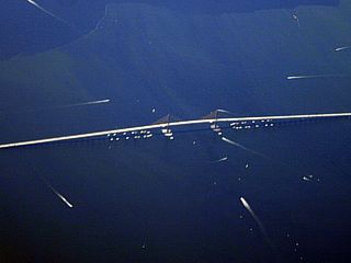
This is a zommed-in picture of the Sunshine Skyway Bridge connecting Bradenton, FL with Saint Petesburg via Interstate 275 across the mouth of the Tampa Bay. This picture was taken from a Boeing 737 that just left Tampa International Airport and headed for Fort Lauderdale, Florida at an altitude of about 12,000 feet. The white "streaks" in the blue water are wakes form numerous boats as it was a Saturday and boating is very popular in Florida's warm coastal waters. The bridge is a single span, center catenary suspension-type bridge with two lanes of traffic on each side of the span. |
|
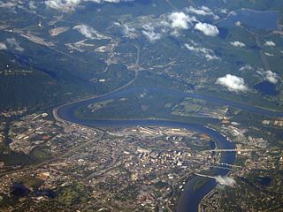
This is Chattanooga, Tennessee viewed from an altitude of about 32,000 feet on a commercial airline flight (in an MD-80 aircraft) ging from Atlanta, Georgia to Saint Louis, Missouri. The four bridges and downtown area (which is near the Tennessee Aquarium) can be seen along the Tennessee river front. The roads to the lower-left that split and snake towards the upper-left are Interstates 75 and 24. Interstate 124 (US 27) is the larger bridge (upper-most in this picture). Lookout Mountain (and Ruby Falls park) is just below the upper-left in this picture.. |
|
This is a picture of portions of Fort Lauderdale, Florida taken from a commercial jet a few thousand feet just off the beach of Lauderdale by the sea. The beach is visible in the lower left as well as parts of Birch State Park. Two major waterways, including the Atlantic Intracoastal Waterway, straddle the "Venice" of Florida where homes and waterways intermingle. To the upper portion of this picture, the area near Sunrise Blvd and Highway US-1 can be seen. |
|
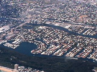
An arial photograph of the Coconut Key housing development in Margate, Florida. This is where I lived and went to school when in Florida as a kid growing up. The picture here was taken from a Pitts Special S2B biplane overflying Margate and Coconut Creek, Florida to land at Fort Lauderdale Executive Airport after a session of aerobatics. My parents and I lived in the house in the upper-left hand corner of the lake. The Pitts Special was piloted by Dagmar Kress. |
|
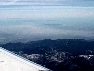
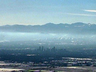
This picture was taken somewhere between Phoenix, Arizona and Las Angeles in California from about 30,000 feet. The view is to the west across the San Bernandino mountains over the LA area. Note the brownish smog, famous to LA, that appears just behind the mountains in the LA basin. Also note the islands off southern California, as the view extends well out to sea, including Santa Catalina Island. |
|
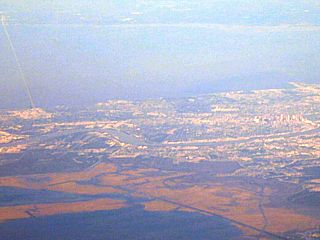
This is a picture of the city of Tampa, Florida taken from a Mcdonnel Douglass MD-80 commercial jet overflying east of the area at about 31,000 feet. Tampa is the city in the bottom and right part of this picture. Note Macdill Air Force Base in the center of the picture at the end of a "penninsula" south of the Tampa metro areas. The blue area is the Tampa Bay and is surrounded by Sarasota, Bradenton, and Saint Petesburg / Clearwater. |
|
This is a picture of the Denver, Colorado just after take-off out of Denver Internadional Airport in the winter. The view is from an MD 80 commercial aircraft. The ground is white from recent snowfall and the front range of the Rockies can be seen in the background. Metro / downtown Denver is the city in the center of the picture. The "haze" in the air is caused by cold air inversion closer to the ground trapping smog. |
|
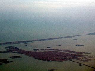
This picture shows the island of Venice, Italy just after takeoff from Venice Internatinal Airport in a commercial Airbus A340 aircraft. In this picture, the "fish shaped" island of Venice, comprised mainly of tightly-packed Renaissance-style buildings interlaced by narrow canals. The view is to the SSW and the main causeway (railway and highway) connecting Venice to the Italian mainland can be seen to the right of the island. The long barrier type island is Lido and separates the other isles and bay from the Meditarranean / Adriatic Sea. |
|
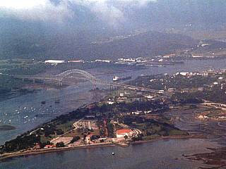
This is a picture of the entrance of the Panama Canal near Panama City in Panama (Central America) from a Boeing 737 aircraft flying over the Pacific Ocean near the area at about 6,000 feet. The canal clearly runs from the lower-left to the upper-right side of the picture. The bridge is the "Puente de las Americas" (Bridge of the Americas) where the Pan American Highway crosses the canal. A large ship can be seen proceding farther into the canal just past the bridge. |
|
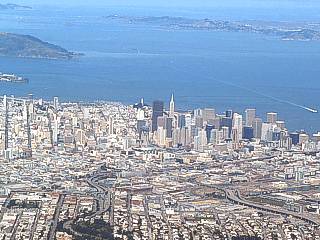
The famous skyline of San Francisco, California can be seen in this picture on a flight from San Francisco to Houston, Texas just after take-off at an altitude of about 3,500 feet. Note the land-mark Transamerica building in the center of downtown San Francisco as well as Alcatraz Island in the upper-left portion of the picture. Aircraft was an MD-80. |
|
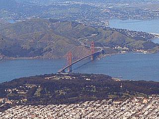
This picture shows the majestic Golden-Gate Bridge near San Francisco, California just after departure on a commercial flight from San Francisco to Houston, Texas from about 4,000 feet. The picture was taken from an MD-80 aircraft. The heavily populated area in the foreground is Daly City. |
|
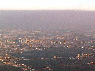
Taken out of a commercial MD-80 aircraft from about 3,000 feet on pattern / approach into Houston / Bush International airport (IAH), downtown Houston, Texas is visible below a "haze horizon" of oil-refinery smog. The view here is looking to the east while entering the landing pattern on a flight originating in San Francisco, California. |
|
The skyline of Minneapolis / Saint Paul, Minnesota appears out the right side of a commercial Airbus 320 aircraft just after takeoff and ascending through 3,000 feet. The view here is looking to the north en-route from Minnespolis to Tampa, Florida. |
|
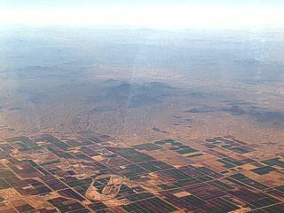
Here is a picture taken out of a commercial MD-80 aircraft from about 30,000 feet over the extreme southeastern portions of California. Can you see Mexico? Here's a hint, note the region where all the farms and "civilization" stop ... That's the BORDER! After that, there is nothing but barren, dry mountains and desert. |
|
This is another picture taken out of a CRJ-700 commercial aircraft from 27,000 feet over Calexico, California. Looking to the south and southwest, the large city you see in this picture is across the border and is Mexicali, Mexico. The US-Mexico border is in the extreme tip of the lower-right side of the picture (the US side of the border has no "buildings" in a small sliver of the lower-right hand corner). |
|
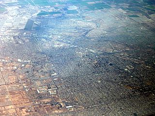
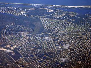
This is an interesting feature that caught my eye on a flight from Tampa, FL to Fort Lauderdale. Here we are on a Boeing 737 at about 23,000 feet, looking southwest at Rotonda, Florida in Charlotte County. This is a deed-restricted retirement community, but with an unusual "sector" layout as opposed to "blocks" as most cities are contructed. From the air, the city appears as a broken wagon wheel, and is very reminescent of the layout of the "Burning Man" event in the Black Desert. The "break" in the "wagon wheel" to it's upper-left is a golf coarse and park. |
|
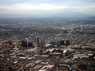
This is a picture of downtown Phoenix, Arizona just after take-off in an Airbus A300 aircraft near Phoenix international Airport on a west-ward departure. The view is to the north and northwest. Phoenix, Arizona is a large desert city surrounded by mountains and the rugged terrain of the Desert Southwest US. |
|
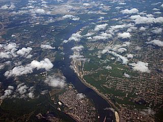
This picture was taken from a Boeing 717 flying from Atlanta, Georgia to Dayton, Ohio from an altitude of about 25,000 feet. The view is the Ohio river and surrounding portions of Cincinnati, Ohio. To the far upper-left, and across the river in Kentucky, is Cincinnati / Northen Kenticky International Airport (CVG). |
|
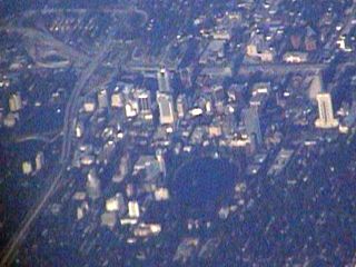
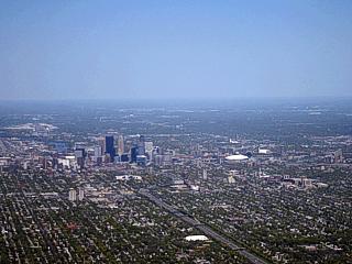
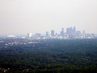
Here is a picture of downtown Atlanta, Georgia taken during final approach from an altitude of roughly 1,500 feet on a Boeing 717 commerical aircraft into Atlanta's Hartsfield Airport. The Georgia Dome arena can also be seen just to the left of the downtown Atlanta skyline. |
|
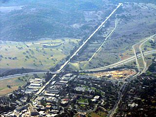
This is a picture of the Stanford Linear Accelerator (LINEAC) taken from a Boeing 737 commercial aircraft at an altitude of about 5,000 feet over San Jose, California. This is one of the longest buildings in the world, and houses magnets to accelerate sub atomic particles (such as electrons) to a target for various particle physics experiments. The structure runs west to east and crosses under Interstate 280. |
|
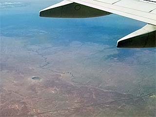
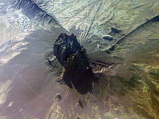
This is a picture of the Barringer meteor crater (east of Flagstaff in the Arizona desert) from a Boeing 737 flying (at about 36,000 feet) from Fort Lauderdale, Florida to a stopover in Las Vegas in August 2018. The crater is in the lower-left side of this picture. The view is towards the SSE. |
|
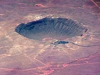
Closer (zoomed-in) view of the Barringer meteor crater showing the nearly 3/4 mile width and 560 foot depth with the visitor center on the northern rim (lower part of the crater in the picture as the view is to the south). |
|
This is a picture of the extreme southeastern side of Lake Meade and Hoover Dam taken from a Boeing 737 flying from Las Angeles to Chicago in August 2015. The Mike O'Callaghan - Pat Tillman Memorial Bridge (Route 93) can also be seen, and is approximately 1/4 of a mile downstream of the dam, and rises 900 feet from the river below. Hoover Dam itself is over 726 feet high. Also note the low water levels (denoted by the large lighter "bathtub ring") in Lake Meade due to extreme drought conditions over Nevada / California at the time. |
|
Here is a picture of the San Andreas fault (crossing from left to right in a diagonal across the center of the image). This is near the Carrizo Plain in central California lying about 150 miles to the northeast of Los Angeles. The picture was taken from an aircraft overflying the area from San Francisco to Florida at an altitude of 35,000 feet. The San Andreas fault is a large fault separating the North American plate (lower part of the image) and the Pacific Plate (upper part of the image), and is notorious for causing severe earthquakes. |
|
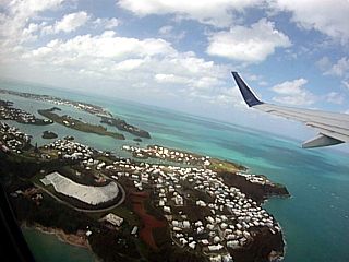
This is a picture of the eastern end of the beautiful island of Bermuda just after departure (the view includes St David, with the lighthouse visible to the lower right). The picture was taken from a Boeing 737 departing Bermuda and headed to Atlanta, GA (in the USA) after hurricane Igor affected the island in September 2010. |
|
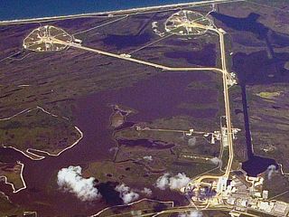
Here is a view of a portion of Kennedy Space Center in Cape Canaveral, Florida. The vehicle assembly building (or VAB) can be seen to the lower-right as well as the two shuttle launch pads (39a and 39b) along the top of the picture near the coastline. The view is looking down and to the NE from a Boeing 737 commercial airliner enroute to Miami (from Toronto) and overflying Titusville, FL at about 40,000 feet. |
|
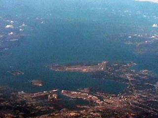
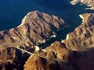
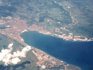
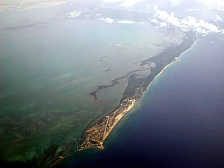
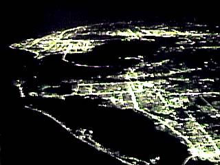
This is the Niagara Falls area (Canada and New York), taken from a Boeing 737 commercial airliner on a flight from Miami, Florida to Toronto in Ontario (Canada) from an altitude of about 23,000 feet. Although appearing small from such a height, if you look closely you can make out some features in the photo. To the left of the picture is the American Falls (white area) and the Skylon Tower's faint silhouette can be seen in front of the falls. Just to the right of that (center of photo) is Horseshoe falls and the rapids leading up to it. |
|
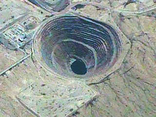
This is a picture of the abandoned Sacaton open-pit copper mine to the southeast of Casa Grande. Arizona taken from a Boeing 767 flying from California to Florida at an altitude of about 35,000 feet. These open pit mines can be hundreds of feet deep. In this mine, the spiral terraces allow large trucks and earth movers to haul the tons of raw copper ore out of the "hole" and to the refinery. Note the "lake" at the bottom of the hole where the water table is reached by the great depth. The mine is about 900 feet deep and has been abandoned since the 1980's. |
|
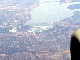
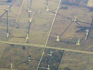
Here is a picture of a wind farm (wind turbines to generate electricity) in Northern Illinois from a Boeing 737 at an altitude of about 18,000 feet. Wind turbines are an increasingly popular sight across the central USA / Great Plains (Midwest), providing clean, renewable energy for many. |
|
This is a view, looking northwest towards the New York metropolitan area from a Boeing 737 at an altitude of about 25,000 feet. To get a bearing, Staten Island (and behind that, New Jersey) is to the extreme left portion of the image. Going eastward (right) is the New York Harbor (if you look closely, the Veranzano Narrows Bridge can be seen connecting Brooklyn and Staten Island). To the lower-left is Coney Island, and the Rockaway penninsula. Just right of the center of the picture, a large group of skyscrapers / "urban sprawl" is visible - That's lower Manhattan. The Statue Of Liberty, although too far to be seen in this picture, is near (or slightly right of) the exact center of the image. Long Beach is to the extreme lower-right. |
|
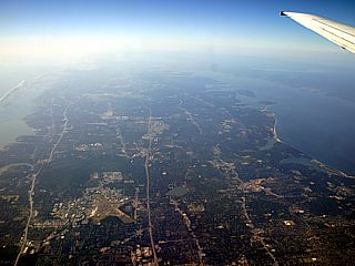
Here is a picture of pretty much where I spent my childhood growing up. This is Lake Ronkonkoma, New York ... Can you find the little lake just below the center of the picture? Ronkonkoma is a small township in Islip (Suffolk County) in the middle of Long Island. The view here, taken from a Hartford, CT bound Boeing 737 overflying the region at about 23,000 feet, shows the view west of the relatively narrow span of Long Island from the south shore to the north shore. Jones beach is to the far left, and the Long Island Sound is to the far right, including the view of Conneticut across the LI Sound. The Hudson river can be seen to the upper right just under the wing. Awesome visibility allows the two major east to west highways across the island to be seen, to the left is Sunrise Boulevard, and right of that (center of picture) is Interstate 495 (the LI Expressway, or LIE). |
|
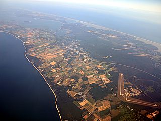
This picture was taken over the Long Island Sound, and is looking to the east and southeast showing the north and south "forks" (upper-left portion of the picture) of the eastern end of Long Island, New York. The photo was taken from about 20,000 feet, in a Boeing 737, flying from Fort Lauderdale, Florida to Hartford, Conneticut. The large bay between the "forks" of Long Island is the Peconic Bay. The large airfield to the lower-right portion of the picture is Grummen Aerospace center. |
|
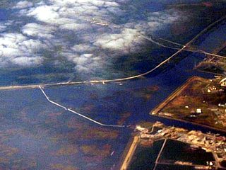
Here is a picture of the New Orleans storm surge barrier, to the southeast of New Orleans Louisiana area taken from a Boeing 767 flying from Fort Lauderdale, Florida to San Francisco, California at about 38,000 feet. The structure can be seen at the entrance of the Rigolets waterway separating Lake Pontchartrain to the west and Lake Borgne that opens to the Gulf of Mexico to the east. The view is looking to the south and southwest. The Interstate 10 Bridge can be seen to the far right in the picture. The barrier is a massive construction project, designed to last at least 150 years, and should prevent another repeat of Hurricane Katrina in 2005, and can block a massive storm surge up to 28 feet high. The Rigolets entrance into Lake Pontchartrain is how the devastating storm surge from hurricane Katrina affected New Orleans back in 2005 during hurricane Katrina. |
|
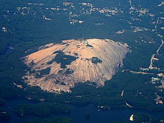
This is a picture of Stone Mountain that is northeast of Atlanta, Georgia as seen while turning for final approach into Atlanta's Hartsfield Airport in a Boeing 717 at about 6,000 feet. Stone Mountain is an interesting outcrop of igneous (volcanic) rock that "bubbled up" from otherwise flat terrain. The mountain has few trees and is basically a solid "rock" with most of its volume still deep below ground (like an iceberg). The mountain has a state park, visitor center, and even a tram to its summit. |
|
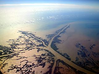
Here is a picture of the intricate tree-branch-like structure of the Mississippi River delta extending out into the Gulf Of Mexico looking south and east from a Boeing 757 commercial airliner flying at about 36,000 feet over coastal Louisiana near New Orleans. The complicated delta is comprised of marshlands and numerous river branches with deposited river sediment built up over many years. The gulf of Mexico appears "muddy" in color due to the sediment laden water being discharged from the end of the "Mighty Mississippi" River. |
|
The Florida Everglades swamp appears as a "river of grass" under a Boeing 737 at an altitude of about 5,000 feet while approaching Fort Lauderdale airport from the west. The typical alligator laden swamp appears as green vegetation (mostly sawgrass with a few cypress trees) and a "shiny" surface of water (averaging 18 inches in depth). This picture was about 15 miles west of Highway 27 over the Miccosukee / Seminole Indian reservation land areas (mostly swamp). Interesting enough, you can even see the reflections of the clouds in the water of the Everglades, almost like a "mirror with green dirt on it". |
|
This is a picture of Cape Fear, near Wilmington, North Carolina from an altitude of about 35,000 feet in a Boeing 727 commercial aircraft flying from Boston, MA to Fort Lauderdale, Florida. Cape Fear is in the lower portion of this picture. Note the cloud formations denoting sea breeze fronts as well as the southeastern North Carolina coastline. |
|
This is a picture of Cedar Key in Florida's "Big Bend" area extending into the NE Gulf Of Mexico taken from a Mcdonnel Douglass MD-80 commercial jet overflying the area at about 31,000 feet. Note the long causway connecting this resort area to the Florida mainland. |
|
This picture was taken from a commercial Boeing 737 from Panama City, Panama to Miami, Florida on Aerolinea Copa at about 35,000 feet. The bay here is on the north coast of the island of Cuba and the city of Matanzas appears grey. Copa airlines is one of the few airlines authorized to overfly Cuba. By looking at this picture, it is hard to imagine the political and social problems, maybe the only sign is the lack of boats in the blue water. Matanzas is just east of Havana. |

|
The gulf stream current becomes apparent as a deep blue colored water a few miles off Fort Lauderdale beach when viewed from a jet aircraft flying overhead. The darker water to the left is stained by algae and other marine life such as plankton and is also much cooler than the water in the gulf stream current. The water in the gulf stream, to the right, lacks plankton and algae and appears much deeper blue. Since the two waters differ in temperature and current flow, they do not mix readily, forming a distinct boundary between the two waters as shown in this picture. The other dark streak across the blue water is a cloud shadow. |
|
This is a picture of a portion of the Mississippi River from an altitude of about 39,000 feet over Mississippi while flying in a Boeing 767 Commercial aircraft. The small objects in the river are acually large barges and ships. This mighty river empties the entire central United States into the Gulf of Mexico. The sides of the river in this region are set in concrete to prevent the river from changing its course. Note the fertile farm lands as well as industrial regions that surround the river. |
|
While flying from California to Arizona, we pass high over the snow-covered peaks of the Rocky Mountains. From about 30,000 feet, the 12,000 foot plus peaks spread out below us and abruptly give way to the lower desert terrain to the east. The mountains here are the eastern Sierra Nevada mountains. |
|
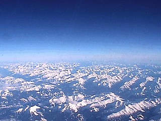
This picture shows the peaks of the Alps mountains while flying high over Switzerland in a commercial Airbus A340 aircraft. This picture was taken from an altitude of about 20,000 feet. The snow pack is also very evident in this picture. |
|
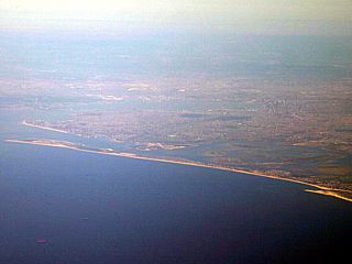
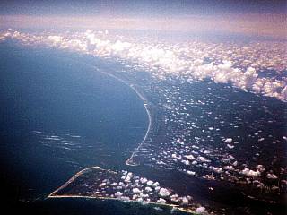
This is a picture of the western tip of Grand Bahama Island while flying out of the south Florida area at about 25,000 feet. The airplane was a boeing 737 and was about 75 miles off the SE Florida coast headed north when this picture was taken. The "town" and airfield at the western tip of the island is Settlement Point (or West-End). The rest of Grand Bahama Island extends to the east. Freeport is in the western center of the island, and is in the upper-right portion of this picture. |
|
This is a picture of Pikes Peak west of Colorado Springs, Colorado from a commercial MD 80 aircraft at about 24,000 feet. The 14,000 foot peak of Pikes Peak rises from the front-range mountains but appears dark because of the sun angle coming from behind the mountain range (the mountain is not snow-free). |
|
Just after taking off from Venice Airport in Italy, the massive Alps mountain range of Northern Italy and Switzerland rise nearly three miles from the near sea-level plains with a majestic snow-pack. Compared to the rockies in America, the mountains west of Denver, Colorado only rise only about half that from the surrounding plains. |
|
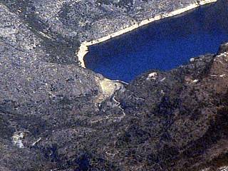
Here is a picture of a dam and its reservoir near Truckee, California along the Eleanor Creek. Not as big, but the same type as the famous Hoover Dam, these dams provide hydroelectric power for the western US as well as maintain a water supply and create an artificial lake. This picture was taken from an MD-80 overflying California at an altitude of about 29,000 feet on a flight from Houston, TX to San Francisco, CA. |
|
Here is a picture of the eastern foot hills west of Mount Hamilton and east of San Jose, California on approach to San Francisco from about 10,000 feet in an Airbus 320 commercial airliner. The foothills give way to the urban "sprawl" of San jose, Milpitas, and Fremont (aka "Silicon Valley") when approaching and descending from the east. |
|
Just after takeoff from San Francisco airport in a commercial Airbus 320 and ascending through 4,000 feet above the socked-in fog / low clouds covering the bay area, mount Diablo (near Concord, California) loomes above the low clouds and below higher cloud layers to to east against the rising sun. This was a flight from San Francisco to Minneapolis / Saint Paul, Minnesota. |
|
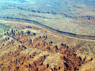
This is a picture of a portion of the Grand Canyon taken out of a commercial MD-80 aircraft from about 30,000 feet over southern Nevada while en-route from Houson, Texas to San Francisco, California. Note the deep chasm with smaller ones in the foreground ... The Grand Canyon is a SYSTEM of canyons that inter-connect over a long distance. The Colorado River created this mighty mile-deep "crack" in the earth over the course of millions of years. |
|
Here is a pictures of the barely-visible snow-covered peaks of the Sierra Nevada (Rocky Mountains) during a flight in an MD-80 at 31,000 feet flying from California to Texas. The dense cumulus looking clouds are actually high-altitude heavy snow-producing nimbostratus clouds and could actually be seen "churning" above the mountains as they were driven by strong winds. A break in the turbulent clouds reveals a mountain peak in the lower left side of the picture. |
|
Looking down from 31,000 feet in an MD-80 from California to Texas and overflying southern Utah, a nice butte (Shiprock Mountain) rises majestically from the high desert floor. If you look closely, you can even see some snow just below the peak of the butte in the shadow. |
|
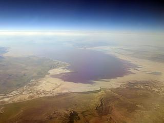
This is a picture of the Great Salt Lake from a commercial Airbus 320 flying from San Francisco to Minneapolis, Minnesota at about 35,000 feet over northern Utah. You can clearly make out the whitish colored salt rim of the lake contrasting to the darker sandstone / granite mountains and surrounding desert. The view is to the south, and Salt Lake City appears in the extreme upper left portion of the picture. |
|
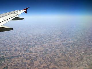
Not that much to be seen in this picture ... It is the flat patchwork of the American Great Plains as seen from a commercial Airbus 320 flying from Minneapolis, Minnesota to Tampa, Florida at about 37,000 feet over central Iowa. Most food in the USA, especially beef, corn, soybeans, and wheat comes from the central US Plains / Midwest. |
|
Here is a picture of a portion of Kennedy Space Center viewed from a Beechcraft King Air ascending through 10,000 feet over Titusville, Florida (Skydive "Space Center"). The large "cube" just left of the center of the picture is NASA's massive VAB (Vehicle Assembly Building) where large spacecraft are constructed and / or prepared for flight. The buildings surrounding the VAB include launch control centers, laboratories, and storage buildings. The "road" leading from the VAB towards the top of the picture (with a fork in it) is the "crawler" pathway where spacecraft (such as the space shuttle) are transported to the launch pads. |
|
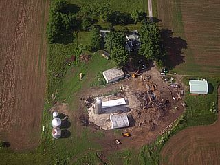
This is a picture of one of many farmsteads across the Midwestern United States. This picture was taken from a Boeing 717 on final approach into Dayton, Ohio from an altitude of about 1,500 feet. In such a close fly-over, one can easily make out the barn under construction, grain / feed silos, outbuildings, freshly-plowed fields, and the main homestead surrounded by trees. |
|
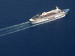
This is a cruise ship about 10 miles east of Fort Lauderdale, Florida while turning base-crosswind for final approach into Fort Lauderdale Airport in a Boeing 717 at about 4,000 feet. Obviously, this approach / pattern takes us out over the coastal waters of Florida, the boating capital of the world. |
|
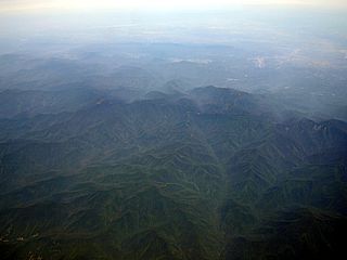
Here is a picture of the Smokey Mountains taken from a Boeing 717 commercial aircraft at an altitude of about 31,000 feet. The flight was from Dayton, Ohio to Atlanta, Georgia. This is a portion of the southern Appelacian mountains, and is most likely near western North Carolina. |
|
This picture is looking down at the US / Mexico border while overflying El Paso, Texas en-route to Houston from Los Angeles, California on a Boeing-737 at 38,000 feet in October 2020. The distinct "yellow" line is the border and is lit by low-pressure sodium lights. Mexico is to the upper-right and the USA (Texas) is to the lower-left. |
|
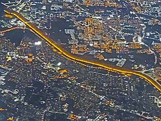
This picture was taken during approach into Midway Airport in Chicago, Illinois in August 2015 during the late evening. The large urban blocks of street lights and towering sky scrapers can be seen in the background. The altitude here is roughly 1,500 feet on a Boeing 737. |
|
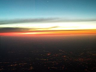
A beautiful sunset, as well as the planet Venus (bright "dot" in the top of the picture), looms high over Indianapolis, Indiana (city lights in the lower-right portion of the picture) in late winter. The picture was taken from a Boeing 737 at an altitude of about 25,000 feet (en-route to Chicago). |
|
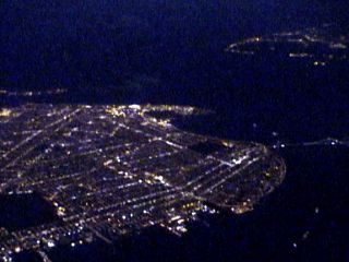
This picture shows downtown Miami at night, taken from an Embraer Regional Jet at an altitude of about 12,000 feet. The view is to the south, and the major roadway is Interstate 95, which ends near downtown (sky-scrapers) just to the left and slightly up from the center of this picture. South Beach and the Biscayne Bay is to the far upper left. Little Havana is to the upper right, and Liberty City is just below the center of the picture. Miami, the "city of lights", is impressive when viewed at night from an airplane. |
|
This is a view of Atlantic City, New Jersey from a Boeing 737 commercial aircraft at about 30,000 feet flying from New York to Florida. This zoomed in night time picture shows the Atlantic City area as well as casinos along the oceanfront as the brightest lights. Atlantic City is a famous gaming area on the southern New Jersey coast. It is on a small island, and the two bridges connecting it can be seen in the foreground. |
|
This is a view of Brooklyn in New York just after dusk while climbing out of La Guardia airport from an altitude of about 11,000 feet in a Boeing 737 directly over downtown Manhattan. In this picture, the city lights mark the towns in Brooklyn including Kenarsy and Bensenhurst in the center and left of the image. The Varranzano Narrows suspension bridge connects the gap with Staten Island to the right. Note the New Jersey coast in the far upper right. Coney Island is the bright lighted area in the far side of Brooklyn (probably from the Astroland Amusement Park). The penninsula in the far upper left is Rockaway. |
|
This picture was taken just after sunset headed west in an MD-80 commercial jet at about 36,000 feet. The vibrant colors of the high-altitude sunset nearly overpower the dim view of the Gulf Of Mexico and barrier islands (most likely Cape San Blas) of Apalachi Bay in the bottom of this picture. Apalachicola and the Apalachi Bay is in the Florida western panhandle along the Gulf Of Mexico. We were about 20 miles north-northeast of Apalachicola when this picture was taken. View is looking to the southwest. |
|
This is a video frame-grab of Havana, Cuba at night, using only the city lights as illumination, taken from a commercial Boeing 737 from Panama City, Panama to Miami, Florida on Aerolinea Copa at about 37,000 feet. The coastline of northern Cuba is also discernable in this picture. |
|
This is a view of New York's central Manhattan just after dusk while climbing out of La Guardia airport from an altitude of about 8,000 feet in a Boeing 737. The East river and Queens is in the foreground. The Empire State Building is in the center of this picture as well as the old Citibank building to its right. The Hudson river separates New Jersey in the background. This picture was taken only using the lights from the city. |
|
This is a picture of the Tampa Bay area on the Florida West Coast taken from a Mcdonnel Douglass MD-80 commercial airliner enroute from Dallas, Texas to Fort Lauderdale, Florida. At night at about 29,000 feet, we can see the barrier islands of Longboat Key and Sarasota to the lower left of the picture, Bradenton in the center, Clearwater and St Petesburg to the upper left and Tampa to the upper right. City lights provide all the light for this picture, the dark areas being the Tampa and Sarasota Bays as well as the Gulf Of Mexico to the left. |
|
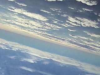
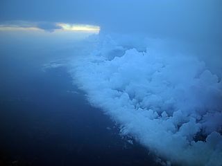
This picture was taken from flight 2129 (FLL to MDW) while over northern Florida (in the position denoted in the diagram at the top of this section above) and at an altitude of 38,000 feet at about 7 PM EDT on August 22, 2008. The un-mistakable circulation center of tropical storm Fay becomes apparent as we break out of heavy cirrus clouds and light turbulence and are greeted with this clear and perfectly smooth air. The center of the storm is cloud filled in the lower levels (because it's over land), and is marked by the "swirl" in the lower clouds to the middle-right side of this picture. Deep (thunderstorm) convection surrounds this clear "eye" with a large convective cell just to the lower-left in the picture. The view is to the southwest, where there is a "break" in the convection around the storm. Thunderstorms and rain surrounds this relatively clear area far below us. |
|
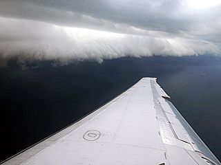
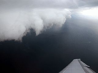
This is a picture of a thunderstorm shelf cloud viewed from an MD-80 commercial airliner at about 3,500 feet. The view is towards the west-northwest and the storm producing the gust front is over Fort Lauderdale, Florida. The aircraft, along with several others, is in a low-level "holding pattern" and waiting for the storms to weaken. About 10 miles offshore of Miami-Dade / Broward counties, the view of the storm gust front and associated shelf cloud is spectacular. |
|
Here is another picture of the same storm gust front and shelf cloud as in the picture above. When cleared to land, we had to fly through and over this menacing cloud (bumpy!) and come into Fort Lauderdale to land behind the line of storms. This flight was also delayed over an hour. |
|
This is a picture of the anvil of a severe thunderstorm over the west coast of Florida (near Tampa) taken from an MD-80 Commercial aircraft at about 34,000 feet. The storm is being circumnavigated (going around it) presenting this beautiful view on the sunlit (western) side of the storm complex. The storms are much higher than our crusing altitude of 34,000 feet (they can be as high as 55,000 feet, or more). The flared and flat top of the storms resemble the shape of a blacksmith's anvil, hence the name "anvil", and is caused by the warmer air of the stratosphere above the bitterly cold upper-troposphere. The undulations under the backside of the anvil are called "bulbs" (large undulation to the left) and "knuckles" (smaller undulations). Strong winds aloft (at about our altitude) are stronger than the winds at anvil-level and near the ground, and create a "backsheared anvil" as we can see here. The view is to the south. |
|
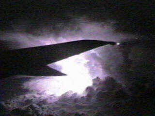
During a flight on a commercial Boeing 737 from North Carolina to Florida, a supercell thunderstorm was passed within 10 miles near Orlando, Florida. Both a tornado and severe thunderstorm warning were issued with this storm. This picture was taken at night, with only the lightning's light, at 35,000 feet. The storm top was up to 60,000 feet. |
|
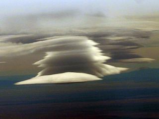
This is a picture of what is called LENTICULAR clouds (Latin for "lens shaped"). These occur in stable air being orographically lifted either over a mountain or to the lee (downwind side) of a mountain range. In this case, strong winds form turbulence in the lee of the Rocky Mountains over southeastern Colorado and form a "lee wave" effect. The waves cause stable and moist air to rise up, then fall again along the lee wave(s) forming these very interesting types of clouds. The clouds remain in one spot, and the formation begins on it's upwind side and disippates on it's downwind side. In an MD-80, flying from California to Texas at 31,000 feet, we were fortunate to be above the severe turbulence associated with this phenomenon. |
|
This is a picture of a cold frontal area somewhere over the Louisiana / Mississippi area from an altitude of 31,000 feet. The picture was taken from a Mcdonnel Douglass MD-80 flying from Florida to Dallas, Texas. Note the higher showers and thunderstorms to the upper left portion of the picture. A layer of mid-level clouds extends from that area to about the right to right-center of the picture. Low clouds continue farther to the right but become thinner behind the cold front. The view is to the southwest. Can you see the "line" marking the outline of the surface front on the underlying cloud deck? |
|
This is a much better picture of a cold front over northern Florida viewed from an altitude of 33,000 feet. The picture was taken from a MD-80 flying from Fort Lauderdale, Florida to Saint Louis, Missouri. In this picture, the storm line associated with the cold front is to the right, but the frontal boundary itself (the line separating the cold and warm air) appears as a curved line extending up and down across the center of the picture. The warm (clear) air ahead of the cold front is to the left. The view is to the west and southwest. |
|
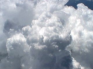
While climbing out of the South Florida area, at around 20,000 feet over the Florida Everglades in a Boeing 767 Commercial jet, solid cumulus and cumulonimbus clouds well up through the tropical atmosphere as sea breeze fronts converge over the area. You could actually see the cloud tops "billowing" upwards towards us. These clouds also developed into full fledged thunderstorms. |
|
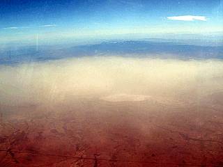
Here is a picture taken out of a commercial MD-80 aircraft from about 30,000 feet over Arizona. The yellow "dust" in the foreground is a full-fledged sandstorm raging in the desert below. Sand storms normally are "surface-based", and can be safely over-flown by most aircraft. The strong winds necessary to pick up such dust and dirt was caused by an advancing area of high-pressure over the desert US southwest. |
|
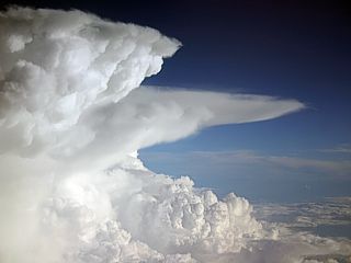
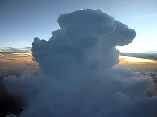
This is what many pilots call a "Charley-Bravo", which is a phonetic radio-name for "CB" or "cumulonimbus". This is a picture of a single thunderstorm cell (cumulonimbus cloud) rising to great heights (these can go as high as 60,000 feet or more)! In this picture, taken from an MD-80 commercial jet airplane, we are cruising at 33,000 feet. The top of the thunderstorm is much higher than that. Note the sun-lit top of the cumulonimbus. This cloud also contained lots of lightning. The storm has not formed an anvil yet because its top has not yet been "pushed" flat by the global temperature inversion (top of troposphere). |
|
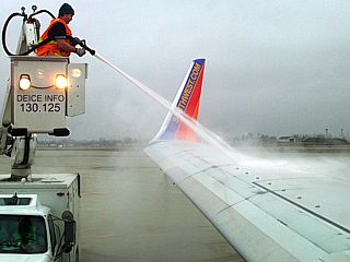
Here is a picture of de-icing operations, a very important safety precaution, at Buffalo / Niagara International Airport in New York in early March 2009. The de-icing crew is spraying an alcohol / water based de-icing agent on the wings so that ice formation is mitigated during climbout, especially when flight is expected through clouds containing supercooled water (water droplets at higher altitudes that can form ice on contact with the cold surfaces of the aircraft). Ice formation is a serious safety issue as it can disrupt airflow over thye aircraft wings / control surfaces and is to be avoided. |
|
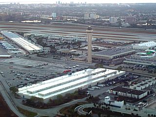
This is a picture of the control tower and southern terminals / airport infrastructure of the Miami Internatiol Airport just after takeoff in a Boeing 757. The view is to the southeast. The Biscayne Bay can be seen in the far top-side of the picture. |
|
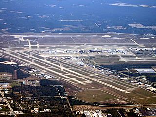
Here is an aerial (from about 5,000 feet or so) of Houston (George Bush) International Airport (IAH) taken from a Boeing 757 on base approach from Fort Lauderdale, Florida. The view is to the north, and the control tower can be seen to the far mid-right portion of the picture. |
|
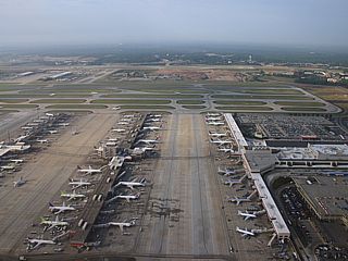
This is the terminal area of Atlanta (Hartsfield) International Airport (ATL) taken from a Boeing 717 just after take-off on the north side runway. This busy airport is a major hub / headquarter for Delta Airlines and Airtran Airways. Three major terminals can be seen in this picture with planes and gates on the tarmacs (ramp / aprons). The massive parking and ticketing structure is to the right. Terminals are linked by an underground transit system. |
|
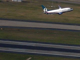
An Airtran Airways Boeing 737 takes to the sky on the southern runways of Atlanta's Hartsfield International Airport (ATL). This picture was taken from a Boeing 717 departing parallel to the southern runways on the north side of the airport. The pattern this morning had planes departing to the west. |
|
This is a picture of the runway at West Palm Beach (PBI) International Airport just before taking off in an MD-80 commercial airliner looking to the east. We are lining up and just are about to begin our take off roll. Note the other airliner at the far end of the runway just about to leave the ground. |
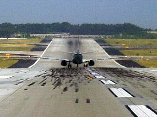
|
A Boeing 737 begins her take-off roll for a westward departure on the north side of Atlanta's Hartsfield International Airport (ATL) on a busy Monday morning with near-perfect travel / flying conditions. Also, interesting in this picture is that the runway at Atlanta is not completely flat, but runs across a mild hill. |
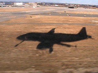
|
A beautiful silhouette of a commercial Airbus A340 appears on the grounds of John F Kennedy Airport (JFK) during final approach into New York. Note the extended landing gear in the shadow on the grassy ground just before the runway threshold. |
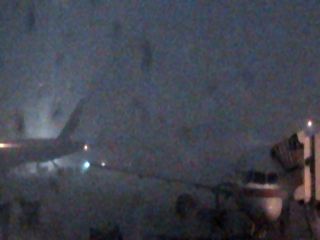
|
This is a view of the outside of the gate area for American Airlines at Miami International Airport (MIA) in concourse D during a severe thunderstorm. Visibility is nearly zero (you can barely make out any silhouettes of planes and support vehicles) and winds are gusting over 65-MPH. This storm shut down all flights for about 3-4 hours, and caused large delays because of such ramp (apron / tarmac) closures. |

|
Flight delays and cancellations can be one of the most frustrating, miserable, and stressful times for air travelers. A large crowd of people await their severely delayed flights out of Miami International Airport (MIA) as severe thunderstorms shut down the airport and flights for a few hours. Many with connections in other cities will miss them, and most likely have to re-schedule and / or sleep at the airport. Important engagements and meetings will be missed. Tempers (air rage) may flare. Since this is the weather (thunderstorms), there is absolutely NOTHING that can be done about it. |
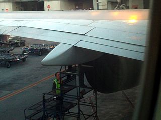
|
Here is a picture of the maintenance crew trying to isolate a hydraulic fluid leak near the left engine of a Boeing 757 aircraft at Miami International Airport. This flight wound up being grounded, forcing all passengers to deplane and be re-scheduled, stranding many passengers in Miami. |
|
These passengers spend the night here, sleeping at the airport using luggage as their "pillows", after a cancelled flight due to mechanical problems. Airlines can only do so much to accommodate stranded passengers due to flight cancellations / delays, and the "floor" is the only alternative to a "bed", unfortunately. |
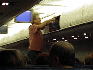
|
People just don't get the fact that the overhead luggage rack will not fit a bag that is larger than the bin! This passenger tried and tried to fit his bag in the overhead bin, standing on an armrest to try to "muscle" it in. The flight attendant was more than happy to check this gentleman's bag. |
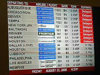
|
With tropical storm Fay over Florida, and a wide swath of weather, thunderstorms, wind, and rain surrounding the storm, many flights at Fort Lauderdale airport were severely delayed (for more than 1 hour) in August 2008. Frustrated air travelers had to deal with arriving at the airport and seeing the "red" messages on their flights, or, if it was not "red", it left at least an hour or two later than the flight was supposed to. |
|
Here is a picture from a Boeing 737 flying from Los Angeles to Chicago of the Ivanpah Solar Power Facility in the Mojave Desert from about 37,000 feet. Basically this is a large set of mirrors, called heliostats, which aim sunlight to a central "receiver" tower. The concentrated sunlight heats the tower white hot (there are three of them in this picture), producing high pressure steam for a turbine that generates electricity. |
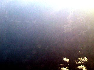
|
Here is a picture looking down from abo0ut 30,000 feet to the southeast of Grand Aisle, Louisiana and to the southeast of New Orleans in May 2010. The discoloration seen in the Gulf of Mexico is part of the oil slick left by the BP oil rig incident. This was the worst oil rig disaster in US history for the Gulf of Mexico. |
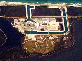
|
This is a picture of the Saint Lucie nuclear power plant seen during descent (at about 18,000 feet or so) on a flight (Boeing 737 commercial airliner) from Toronto, Canada to Miami, Florida. The two containment buildings, typical of most nuclear power plants, are to the left of the center of the image. The large canal running through the facility is for cooling water, eliminating the need for large cooling towers seen at plants that are not near a large body of water, such as the Atlantic Ocean and bay (in this case). |
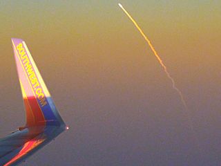
|
Here is a picture of the Space Shuttle "Discovery" lifting off (at Kennedy Space Center) 80-miles east of my flight path on March 15, 2009 at about 7:45 PM EDT. The flight and picture was from between Tampa and Orlando and at an altitude of 38,000 feet in a Boeing 737-700 commercial airliner. I always carry a camera and make sure I get a window seat for "opportunities" like this! |
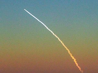
|
Here is a close-up picture of the Space Shuttle "Discovery" in a space-bound climb on March 15, 2009. The lightning and sun angle were pristine for this special "treat" on this flight. |
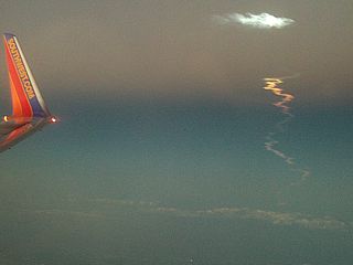
|
About 10-15 minutes after the shuttle launch on March 15, 2009, the rocket plume / contrail begins to disperse. The bluish "cloud" high up is from the solid-rocket booster separation, and is at very high altitude (mesosphere), that's why it is luminous so long after sunset (high above the dusk "terminator" / Earth's shadow). |
|
While flying over the Florida Everglades in June of 2007, during drought conditions, a brush fire burns and sends up a plume of smoke and pyrocumulus clouds. This picture was teken from an altitude of about 10,000 feet while on approach to Fort Lauderdale Airport aboard a Boeing 717 commericial airliner. |
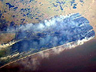
|
Here is another brush fire burning east of Beumont / Port Arthur, Texas while en-route from Fort Lauderdale, Florida to Houston, Texas in a Boeing 757 at about 34,000 feet. Surface winds are from the northeast, wafting smoke behind the flame front, which is good for fire-fighting, since the burned area is upwind indicating a wind-shift recently took place. The Gulf Of Mexico, with a shrimp / fishing boat (the white "dot"), is to the lower right. |
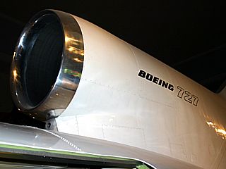
|
This is a picture of the number 2 (centerline) jet engine inlet of a Boeing 727 jet airliner. The JT8-D engine is housed in the tail-cone assembly of the plane, with two additional JT8-D engines (Pratt and Whitney) mounted on pods on each side of the tail. The centerline engine requires an "S" shaped inlet from above the root of the tail, as shown here, and to the lower-rear-mounted engine inlet. This is called an "S Duct" and also was used in the Lockheed L1011 "Tri-Star" airliner and Falcon 50 private jet. |
|
On a rainy day in San Francisco, the engines of a Boeing 757 power-up to takeoff thrust and the jet blast plume, coming out of the left engine in this picture, blasts standing water / moisture off the runway surface mid-way through the takeoff roll. At roughly 20 feet behind the nozzle of the engine (according to engine manufacturer Pratt and Whitney), jet blast can easily exceed 690-MPH. |
|
In a Boeing 757 (flying from California to Texas) at a cruising altitude of 39,000 feet over Nevada / Utah, the sun angle allows the contrail of the aircraft to cast a shadow on a deck of high cirrus clouds below the aircraft. The contrail is the white line of condensation behing high-flying aircraft caused by moisture in the exhaust from the jet engines condensing (then freezing). If conditions at high altitudes are right, the contrail will persist. In this picture, the contrail shadow appears as a dark line across the clouds under the aircraft. |
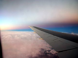
|
This is a picture looking east during a sunset at about 39,000 feet over New Mexico from a Boeing 757 flying from San Francisco to Dallas. An ominous dark band appears across the eastern sky because at this altitude, the shadow of the earth forms an angle across the sky (from left to right in this picture) and the official transition from day to night becomes apparent (caused by dust / light scattering in the upper atmosphere). This is called the Earth's TERMINATOR. There is a dawn and dusk terminator, this picture shows the latter. |
|
This is an annoted diagram of an interesting phenomenon that occurs due to shock wave formation over the aircraft wings during high subsonic cruising speeds. The picture is a closeup of the wing (which technically is a supercritical type NACA airfoil) of an MD-80 commercial airliner at a cruising altitude of 31,000 feet over Tampa, Florida. The afternoon sunlight is bright and shining down on the wing and passes through some of the shock waves that occur over the top of the wing. Although the cruising speed is subsonic (about Mach .76 or so), a small portion of the air flowing faster over the top of the wing becomes supersonic, and a small shock wave develops (this is normal). Light refracts due to the density changes near and in the small shock wave, and can create bright / shadowed lines on the upper wing surface if the light angle is just right. The arrows point to the shadowed / brighter lines created as light refracts through the shock wave. |
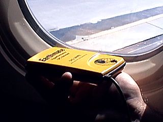
|
The "Delorme Earthmate" GPS is a popular and very handy GPS unit that attaches to a laptop PC running the "Street Atlas" software. In this picture, we decided to put it to the ultimate test ... how would it work in a commercial jet airliner at altitude? Well, that's just what my chase partner Jeff Gammons and I did coming back from the Colorado storm chaser convention. In the picture above, I am holding the GPS antenna close to the plane window to get a good satellite fix, it took a while due to the metal fusalage enclosing us, but eventually locked on in about 10 minutes. The airliner was an MD-80 commercial jet. |
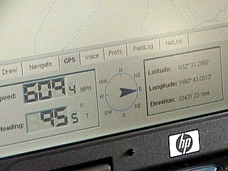
|
Once the GPS was up and running, the software behaved just like it would in a car driving along America's highways, but with several striking differences. First of all, we weren't moving along the roads, but across them, after all, we are flying, not driving. Second was the speed that roadways, rivers, and features went by at was about 10 times as fast as you would see in an automobile. In the picture above, the large numbers to the left show our ground speed and direction azimuth. Note that we are traveling at 609.4 MPH in a direction of 95.5 degrees (slightly S by east). Another thing, check out the "elevation" reading in the right display below the lat / lon displays ... It reads 33431.23 feet. The pilot said we would be at a 33,000 foot cruising altitude on this flight. When this picture was taken, we were northeast of New Orleans flying from Dallas, Texas to West Palm Beach, Florida. |
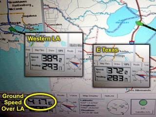
|
This is an annotated picture showing GPS measurements of ground-speed when crossing a region of strong winds aloft associated with the core of a jet stream. The jet stream is a narrow band of global high-altitude winds found above the temperate regions. In this diagram, the first measurement was taken over central Lousiana west of New Orleans, in an MD-80 at about 37,000 feet with a ground speed of about 417 MPH. With an airspeed of 575 MPH (this airspeed was constant in all three measurements, with a heading to the WNW), the jet stream component is about 158 MPH. The next left inset, measured over far west Lousiana, shows a ground speed of 389 MPH, giving a jet component of 186 MPH. Finally, after crossing into far E Texas airspace, ground speed rather suddenly dropped to only 372 MPH (most likely as the "core" of the jet stream, or jet "streak" was crossed), yielding a jet-stream "core" component of 203 MPH. A turn to the WSW, heading more into the strong WSW winds aloft, yielded a lowest ground speed of 349 MPH (not shown), suggesting a jet streak of 226 MPH. Speaking about being "late", imagine flying the other way? |
|
The full moon can be seen clear and bright while flying at about 35,000 feet off North Carolina in a Boeing 737 commercial aircraft from New York to Florida. This view is zoomed in at the nearly full moon looking eastward just after moonrise. |

|
The bright full moon creates a moon "dog" on the surface of a cirrus cloud deck below when looking east from over the US east coast at about 35,000 feet in a Boeing 737 commercial aircraft from New York to Florida. This is caused by ice crystals with flat surfaces (usually tiny six sided plates or needles) making up the ice clouds at high altitudes. These often cast a defined reflection of any bright object, especially the sun (as with sun "dogs"). The moon "dog" appears as the bright spot at the bottom of the image. |

|
This picture is the western sky after sunset taken from a Boeing 737 over Orlando, Florida at an altitude of about 31,000 feet. An hour or so after sunset, the layers of the stratosphere split up the white sunlight into the primary colors due to refraction. Ofcourse, at nearly 6 miles above the earth, with only 1/4 of the atmosphere remaining above, the colors appear much different than a sunset viewed from the ground. Colors also appear more brilliant due to the lack of dust, moisture, and clouds at high altitudes. |
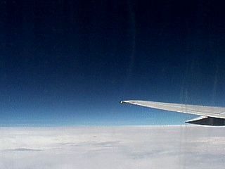
|
This picture was taken from a Boeing 767 jet aircraft at an altitude of about 39,000 feet over the Gulf Of Mexico off the coast of Louisiana looking south in the early afternoon. The cloud deck below us is a layer of cirrus clouds at about 35,000 feet. With nearly 80 percent of the earth's atmosphere below us, the sky is a much darker shade of blue than at lower altitudes in the lower stratosphere. |
|
|
While taking off in a MD-10 out of Honolulu, Hawaii, a phenomenon occurs where the radical pressure drop over the top of the airplane wing allows the high humidity in the air to condense. The condensation usually occurs along the vortices that attach themselves to parts of the aircraft wing and develop in the slipstream. Note the flow of the slipstream over the wing marked by the vortices embedded in and oriented coincident to the flow. |
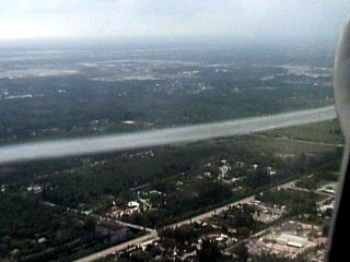
|
This is a picture of a vortex tube just off the right side of an MD-80 commercial jet while on final approach into West Palm Beach International Airport. The vortex is being generated by the aircraft wing to the left (not visible) and continues aft. The jet intake can be seen to the far right of the picture (taken from seat 26F returning from a storm chasing convention). Note the "hollow" appearance of the vortex tube. Aircraft designers place strips of metal along the aircraft wing called "vortilerons" to generate such vortices to create drag and stabilize aircraft while landing. When the wing flaps deploy, the vortilerons set and the vortex is created in the slipstream. If air temperatures and moisture is just right, the associated dynamic pressure changes along the vortex axis causes regalation / condensation and the vortex tube becomes visible. |

|
In this picture we can see an optical phenomenon called a "pilot's glory" (or "Brocken Effect") appearing on a cloud deck below an Airbus A340 commercial aircraft over northern Italy. The glory (or halo) effect is visible only along the line of sight away from the sun (such as towards the observer's shadow on the cloud deck) due to incident rays and light refracted back by cloud droplets / ice crystals (opposition effect). The colors are produced by the white sunlight being refracted like light through a prism. Cloud composition (supercooled water and ice needles in this case over Italy in the winter) also plays a big role in the size and intensity of the pilot's glory. |
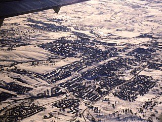
|
A brilliant white sheen can be seen in this picture 10,000 feet over Colorado in an MD 80 commercial aircraft because of nearly a foot of snow on the ground. The new snowfall from a recent snow storm in February 2003 paints a beautiful white landscape southeast of Denver, Colorado. |
|
This is a picture of the view out the window of a Boeing 767 aircraft in the upper-traffic slot of 41,000 feet over eastern Kansas. What is trying to be shown here is that a hint of the earth's curverature can be seen at this height! This picture is looking SE just around sunset. Ofcourse, the sky is very dark because of both the altitude and the twilight. This picture has not been altered in any way, except for the yellow line across the picture to depict a normal planar "horizon" for reference. The "real" horizon just above it, as you can see, shows a slight curverature. |
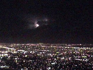
|
This is a picture of the view of a thunderstorm, inwhich lightning has illuminated the thunderstorm cloud, just after take-off from Miami International Airport aboard an Embraer Regional Jet. The "streaks" on the window is rain. The city below is Miami, Florida with its streets and bright lights. The flight (Miami, FL to Cincinnati, OH) was delayed 3-4 hours (out of Miami) because of severe thunderstorms. |
HTML File "flying.htm" - Developed By Chris Collura
To Return To The HOME Page Of This Site Click The "INDEX.HTM" Link Here!