
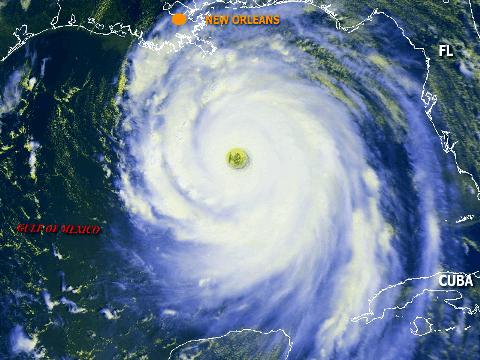
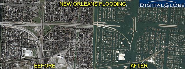
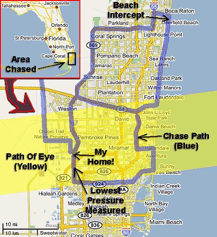
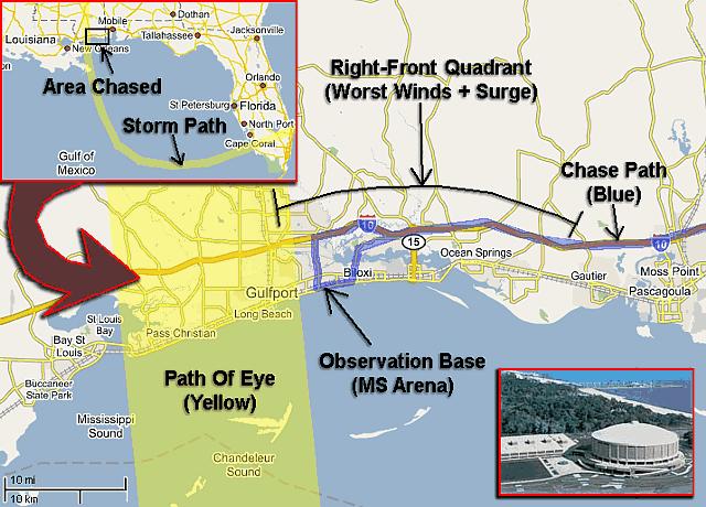
| This area shows pictures taken from the observations and interceptions of devastating hurricane Katrina from Florida through Mississippi. The storm was initially a tropical disturbance that moved off Africa and moved west and northwest until well north of Puerto Rico, where it formed into a tropical depression. This depression weakened back to a tropical wave in unfavorable upper air conditions, but continued to the west and northwest. In the Bahamas, on August 23 and 24, the system became a depression again and then tropical storm "Katrina" on the 24th as conditions became more favorable for strengthening. The storm turned to the west, and intensified, hitting South Florida as an 80-MPH category-one hurricane during the evening of Thursday, August 25, 2005. The first intercept of this storm was done here, from Deerfield Beach southward to north Miami. Katrina then turned to the SOUTHWEST, and crossed the Florida Everglades and into the southeast Gulf of Mexico on August 26. The Florida Keys were battered by the now strong tropical storm Katrina. During the morning of the 26th, back over water, Katrina quickly re-acquired hurricane strength. Meanwhile, I was selected to accompany chaser Jim Edds working for CBS on a NOAA "Hurricane Hunters" flight around and over the storm on the 26th aboard the Gulfstream IV research jet. I put the pictures from this flight on this page too, even though I was just an observer and reported for the 8-hour mission. The flight was out of Mc Dill Air Force base in Tampa with flight director Paul Flagherty. Hurricane Katrina continued to pick up strength, and began its turn to the northwest on Sunday, August 26, 2005. During that same day, the hurricane became a rare category-five storm with sustained 175-MPH winds and a central pressure of 902 MB. A research plane later that same day measured a 234 knot (269 MPH) wind at the 866 MB level making this a record-setting wind speed ever seen in a tropical cyclone. The storm only gradually weakened to a strong category-four hurricane with 140-MPH winds and 918 MB central pressure as it came ashore near Gulfport, Mississippi early Monday, August 29, 2005. This is where the second intercept was done, at the Mississippi Arena on the coast along highway 90 between Gulfport and Biloxi. This second interception was not for the faint of heart. The Mississippi Arena is a reinforced concrete and steel superstructure, and the interception of the devastating core of hurricane Katrina was done there. A storm surge 20 to 25 feet (possibly higher) roared in as the eyewall hit during the morning of the 29th. The surge flooded the first floor, playfield, and lobbies of the arena as most walls and windows there failed catastrophically. At least 5 feet of Gulf water was in the first floor during the height of the storm. Waves about 10 feet high, super-imposed on the storm surge, slammed into any opening or breach created on the first floor. Many cars parked in front of the Arena were washed away (our chase vehicles were moved up a walking ramp and spared). Winds sustained at over 145-MPH blasted on shore for hours with this storm, the eye (calm) passed a few miles to the west of our location and only a wind shift from east, to southeast, then southwest was observed with a lowest pressure of 959 MB measured at our location in violent, sideways rain. Katrina, now inland, was to weaken to a tropical storm on August 30 and dissapate to a remnant low on the 31st near the Ohio valley. Hurricane Katrina left the Mississippi and Louisiana coasts in ruins with many dead and even New Orleans flooded beyond imagination. Let along chasing this hurricane, it is being billed as the worst natural disaster in United States history. The first chase for this hurricane was done in South Florida on August 25 and 610 total miles were logged for it. The hurricane hunter flight was on August 26. The second chase of Katrina was from August 28 through August 30 with the 29th being the main observation day between two "ferry" days to and from the target area of near Biloxi, Mississippi. Total mileage for the second chase was 1,610 miles. Note - This page may take a while to load on some SLOWER connections! |
*** INCREDIBLE FOOTAGE AVAILABLE!! - MEDIA INQUIRIES NOTE MY CONTACT ON MAIN PAGE ***
*** KATRINA WAS A DEADLY STORM - GOD BLESS ALL AFFECTED ***

*** PLEASE CONSIDER DONATING TO THE AMERICAN RED CROSS IN THIS TIME OF NEED ***
*** TO GO TO THE AMERICAN RED CROSS SITE - CLICK HERE ***
*** YOU CAN ALSO HELP BY CLICKING HERE ***
![]() Read "Hurricane Katrina - A Hurricane Chaser's Perspective"
Read "Hurricane Katrina - A Hurricane Chaser's Perspective"
| CHASER NAME | HOME CITY | CALLSIGN | OCCUPATION |
| CHRIS COLLURA | MIRAMAR, FL | KG4PJN | COMPUTER ANALYST |
| JEFF GAMMONS | WPB, FL | KG4PGA | PHOTOGRAPHER |
| JIM EDDS | FLORIDA KEYS | KG4TBE | PHOTOGRAPHER |
Both STOCK Footage and DVD video of hurricane Katrina is available in the SPECIAL OFFERS section of this web site. You can visit that area by clicking either the image above or the link HERE!
URGENT - WEATHER MESSAGE
NATIONAL WEATHER SERVICE NEW ORLEANS LA
1011 AM CDT SUN AUG 28 2005
...DEVASTATING DAMAGE EXPECTED...
.HURRICANE KATRINA...A MOST POWERFUL HURRICANE WITH UNPRECEDENTED
STRENGTH...RIVALING THE INTENSITY OF HURRICANE CAMILLE OF 1969.
MOST OF THE AREA WILL BE UNINHABITABLE FOR WEEKS...PERHAPS LONGER. AT
LEAST ONE HALF OF WELL CONSTRUCTED HOMES WILL HAVE ROOF AND WALL
FAILURE. ALL GABLED ROOFS WILL FAIL...LEAVING THOSE HOMES SEVERELY
DAMAGED OR DESTROYED.
THE MAJORITY OF INDUSTRIAL BUILDINGS WILL BECOME NON FUNCTIONAL.
PARTIAL TO COMPLETE WALL AND ROOF FAILURE IS EXPECTED. ALL WOOD
FRAMED LOW RISING APARTMENT BUILDINGS WILL BE DESTROYED. CONCRETE
BLOCK LOW RISE APARTMENTS WILL SUSTAIN MAJOR DAMAGE...INCLUDING SOME
WALL AND ROOF FAILURE.
HIGH RISE OFFICE AND APARTMENT BUILDINGS WILL SWAY DANGEROUSLY...A
FEW TO THE POINT OF TOTAL COLLAPSE. ALL WINDOWS WILL BLOW OUT.
AIRBORNE DEBRIS WILL BE WIDESPREAD...AND MAY INCLUDE HEAVY ITEMS SUCH
AS HOUSEHOLD APPLIANCES AND EVEN LIGHT VEHICLES. SPORT UTILITY
VEHICLES AND LIGHT TRUCKS WILL BE MOVED. THE BLOWN DEBRIS WILL CREATE
ADDITIONAL DESTRUCTION. PERSONS...PETS...AND LIVESTOCK EXPOSED TO THE
WINDS WILL FACE CERTAIN DEATH IF STRUCK.
POWER OUTAGES WILL LAST FOR WEEKS...AS MOST POWER POLES WILL BE DOWN
AND TRANSFORMERS DESTROYED. WATER SHORTAGES WILL MAKE HUMAN SUFFERING
INCREDIBLE BY MODERN STANDARDS.
THE VAST MAJORITY OF NATIVE TREES WILL BE SNAPPED OR UPROOTED. ONLY
THE HEARTIEST WILL REMAIN STANDING...BUT BE TOTALLY DEFOLIATED. FEW
CROPS WILL REMAIN. LIVESTOCK LEFT EXPOSED TO THE WINDS WILL BE
KILLED.
AN INLAND HURRICANE WIND WARNING IS ISSUED WHEN SUSTAINED WINDS NEAR
HURRICANE FORCE...OR FREQUENT GUSTS AT OR ABOVE HURRICANE FORCE...ARE
CERTAIN WITHIN THE NEXT 12 TO 24 HOURS.
ONCE TROPICAL STORM AND HURRICANE FORCE WINDS ONSET...DO NOT VENTURE
OUTSIDE!
|
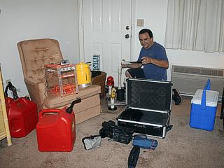
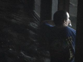
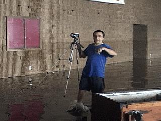
Getting all the equipment and supplies in order, here is a picture of myself a day before the interception of the first landfall of hurricane Katrina. I am setting up the weather station and preparing supplies for the start of a long "spree" of hurricane chasing! |
|
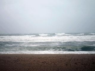
With hurricane Katrina just about to come ashore, high waves batter the Broward County coast in South Florida. The hurricane surf here is being driven by tropical storm forced winds atop a ground swell generated by the storm as it approaches. |
|
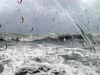
Here is another picture, taken with a waterproof enclosure called the "Surgecam II", of the crashing waves from within the surf zone in neck-deep water. Winds are on-shore here at nearly 60-MPH and whipping the ocean up into a white froth. Picture taken with "Surgecam II" custom-built enclosure for HDR-FX1 camcorder. |
|
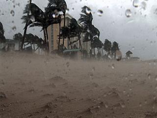
This is a picture of Deerfield Beach, Florida in near hurricane forced winds. Note the flow of sand and erosion taking place. Any camera not protected from such sand will be destroyed in seconds. Picture taken with "Surgecam II" custom-built enclosure for HDR-FX1 camcorder. |
|
Here is a picture of myself standing on the beach in 60-MPH+ onshore winds ahead of Katrina just before making landfall and just before arrival of the hurricane forced wind core. The "sand blasting" is enough to leave small cuts on your legs. Picture taken with "Surgecam II" custom-built enclosure for HDR-FX1 camcorder. |
|
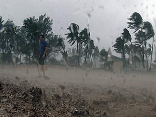
Here is a picture of near hurricane forced winds along the beach at Deerfield Beach, Florida. Note the "sand blast" effect. |

|
Here is another picture of palm trees in Deerfield Beach, Florida blowing in the winds as minimal hurricane Katrina approaches the coast for the first landfall. |
|
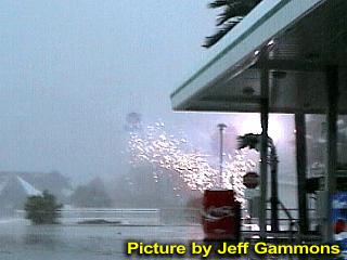
Jeff Gammons was also chasing the landfall of Katrina in Fort Lauderdale. In this picture, a large power flash with sparks flying occurs at a gas station near the 17th street causeway in hurricane forced winds. |
|
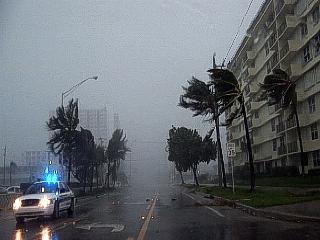
Here is a picture of Pompano Beach in heavy rains with onshore (easterly) winds near 80-MPH just before a powerline cut a connector on top of the roof mounted weather station. This is the right side of the storm eyewall while the eye of the storm is coming ashore south of Fort Lauderdale, 5 to 10 miles away. |
|
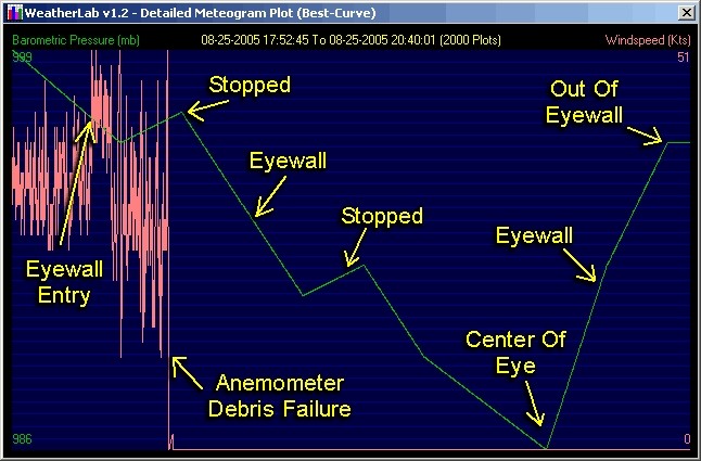
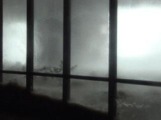
This is a picture looking up into the eye of hurricane Katrina as it just came ashore near the Broward and Miami-Dade county coast in the late afternoon of August 25. The low clouds break and thin high clouds / blue sky peeks through. Pressure measured here was 986 MB (lowest reported official pressure was 984 MB at 80-MPH winds at that time). Note the "curved" appearance of the low clouds in the bottom of the picture. |
|
An eerie calm sets in as the pressure center of Katrina moves over the border of Miami-Dade and Broward counties. In the center of the eye, there was almost no wind whatsoever, and a measured pressure of 986 MB (made landfall at 984 MB). Note the lack of wind (still trees) and no precipitation. |
|
Still in the eye of Katrina, you can see numerous power flashes to the east, getting closer. This is the eastern eyewall and second half moving towards us. The calm now will not last for long. |
|
Finally the second half of hurricane Katrina's eyewall hits, and the winds go right back up to 70-80 MPH, but from the opposite direction as before. In this picture, tree branches are falling into the street as cars dodge them. This is why you DO NOT go outside during the calm of the eye, and unfortunately, 11 people were killed in Florida mainly because of this. |
|
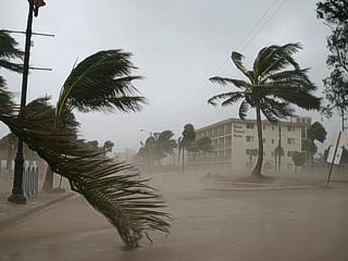
Winds are still strong on the backside of Katrina at Fort Lauderdale beach. The winds and driving rains are from an inner feeder band rotating around Katrina's backside. Winds here are gusting over 60-MPH. |
|
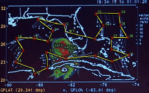
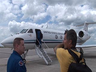
Flight director Paul Flagherty and CBS affiliate Jim Edds (KG4TBE) prepare to board the Gulfstream IV SP NOAA research jet at Mc Dill Air Force Base in Tampa, Florida. This mission studies the upper atmosphere above and around a tropical system, unlike the two other W-P3 aircraft that flight through the eye at lower altitudes. The purpose of such high altitude research is to determine future track and intensity of a tropical cyclone based on data gathered from this Gulfstream IV jet. The code name for the jet, operated by the US Department of Commerce, is "Gonzo" and has an ID of N49RF. |
|
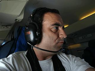
Here is a picture of myself preparing for takeoff aboard the Hurricane Hunters Gulfstream IV jet. The full harness is in case severe turbulence is encountered. My job on this flight was to help Jim Edds, working for CBS in Miami, with his sound and equipment. You need to be a media affiliate or scientist to get on these missions. |
|
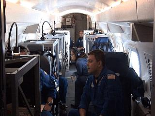
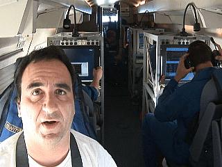
This is a picture of the inside of the Gulfstream IV jet looking towards the rear as NOAA specialists gather and study data during the 8-hour mission. The dropwindsonde operators are all the way to the back of the cabin. |
|
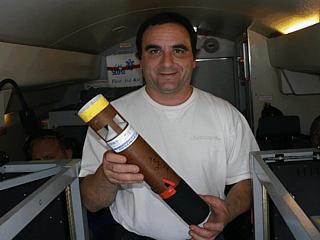
Here is a dropwindsonde. This is an expendable device ejected from the aircraft from high altitudes (usually 41,000 to 45,000 feet). The device has a built-in GPS, weather "station", and telemetry. As it falls through the atmosphere under a small drogue parachute, it measures wind speeds, pressure, dew point, temperature, etc. It takes roughly 15 minutes for the dropwindsonde to descend through the air column and impact the sea surface below while transmitting vital weather parameters back to the aircraft. |
|
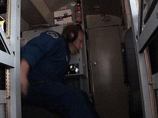
In the rear of the aircraft and forward of the lavatory / galley area is the dropwindsonde station. Two operators load the release mechanism and monitor the status of the device from release until impact 15 minutes or so later. In this picture, the operator is releasing the dropwindsonde for another of a total of 24 drops on this mission. |
|
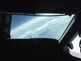
Here is a picture looking forward over the pilot and co pilot's shoulders while flying high over the Central Bahamas. We are in a gentle right turn, and one of the islands can be seen in the lower right side of the windscreen. |
|
Here is a view out the window of the Gulfstream Jet at an altitude of about 45,000 feet. As you can see in this picture, the sky is a much darker blue than it is at lower altitudes. |
|
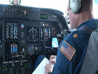
This is a picture of the co pilot and instrument panel of the Gulfstream IV cockpit. This aircraft is a pilot's dream to fly, with what is called a "glass cockpit" of CRT displays and monitors instead of the old analog dials and meters. The flight path is programmed into the computer and that's it, the plane flies itself - Literally! The pilot only monitors the flight and performs any deviations, such as around weather, as well as the take offs and landings. |
|
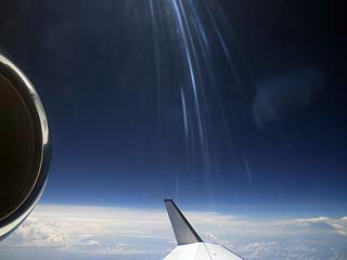
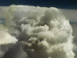
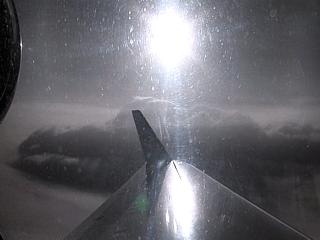
A tall cumulonimbus tower wells up from the tropical ocean below as viewed from straight out the cockpit of the Gulfstream jet. These thunderstorm cells are very easy to go around. The cumulonimbus here is 50,000 feet high. |
|
Here is a picture of myself half way through the 8-hour mission doing both a sound check and giving a short narration of the flight for Jim Edds for our CBS story. |
|
Here is a picture of CBS affiliate Jim Edds doing a commentary in front of a workstation on the Gulfstream jet. |
|
Now we have to fly over or even "through" an intense portion of the hurricane's south side. Our flight path passed within 50-60 miles of the eye of the storm. In this picture, an over-shooting top of a thunderstorm breaches the cirrus shield at 40,000 feet (we are at 45,000 feet). |
|
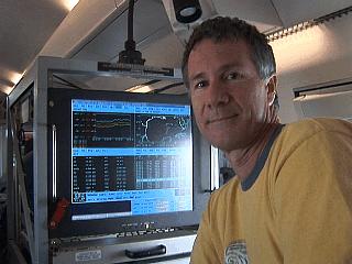
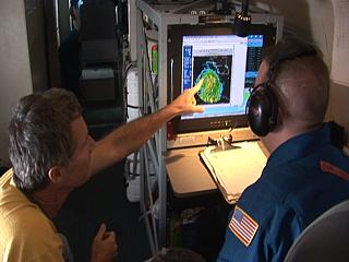
CBS affiliate Jim Edds checks the flight path and intensity image of hurricane Katrina with flight director Paul Flagherty. So much data is available at your finger tips on such a flight, and the aircraft is literally a flying laboratory. |
|
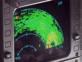
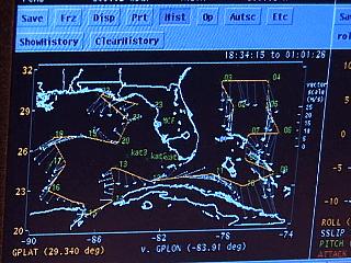
On the radar scope, the unmistakable signature of the hurricane eye and eyewall shows up. Note to the lower-right side of the image, just above and left of the number "4", that's the eye of the storm at 45,000 feet. |
|
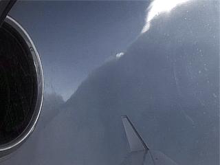
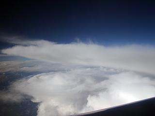
Flying over the intense rain bands and thunderstorms in the hurricane, even at 45,000 feet the tops of the storms loom above us, and we have to go around them. In this picture, taken above the north coast of Cuba and about 60 miles from the storm center, an over shooting thunderstorm top pierces the thick cirrus deck at the top of the hurricane and reaches altitudes near 60,000 feet! You know the storm is intensifying, as these overshooting tops are also seen on visible satellite images, especially when the sun is at an angle where they cast shadows on the cirrus deck. Here we are in one of those shadows. It is bumpy but we quickly get past the weather and continue on with the mission. |
|
Here is another picture of feeder band convection in the Gulf of Mexico west of hurricane Katrina. Note the flattened top of one of the storm cell "anvils" to the lower-left of the center of this picture. |
|
This is a picture of a display showing a portion of our flight path about 7 hours into the mission. We are currently over the Gulf of Mexico off the Florida "Big Bend" area and just about to do our last dropwindsonde release off Cedar Key. Note the flight path (first portion is missing across FL) taking us over the Bahamas, Cuba, Mexico, then the Gulf of Mexico. It was about 3,800 miles long. |
|
The view from 45,000 feet is awesome, can you see the curvature of the earth in this picture - Look at the horizon and see for yourself! Columbus would have loved that. |
|
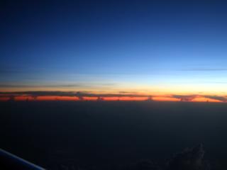
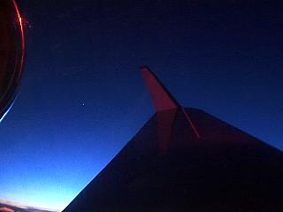
In a gentle turn, the brilliant colors of the sky are revealed just as the sun is setting. Note the bright star between the jet intake and wing. The last of 24 dropwindsondes were released, then it was a rapid descent back down to Tampa at 5,000 feet per minute. We actually PASSED the last dropwindsonde on the way back down - That was wild! |
|
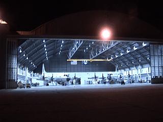
Back on the ground at Mc Dill Air Force Base. Here is a view of the NOAA Aircraft Operations Hangar at the base after stepping off the Gulfstream jet. The two W-P3 "Orion" aircraft cannot be missed. These two heavy, four-engine turboprop beasts are responsible for the lower altitude penetrations of the storm eye. The code names are "Kermit" and "Miss Piggy" and have ID numbers of N2RF and N3RF. |
|
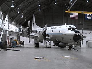
Here is a closer view of one of the two W-P3 "Orion" aircraft. Note the huge radar "pancake" on the bottom of the plane, distinct wide-chord 4-bladed propellers, and "gust probe" protruding from the nose of the plane. |
|
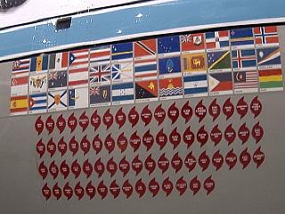
Here is a close-up of the "track record" painted on the side of one of the W-P3 "Orion" aircraft. The flags represent any nation visited by the aircraft respecting diversity and service, while the hurricane symbols with names represent successful storm missions. |
|
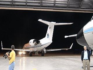
The Gulfstream IV aircraft is rolled back into its hangar for the evening at NOAA Aircraft Operations after the important and successful recon mission. Jim Edds is in the yellow shirt to the left. The data gathered by this flight became a crucial forecasting element as hurricane Katrina was aiming at the northern Gulf coast at the time and intensifying rapidly. |
|
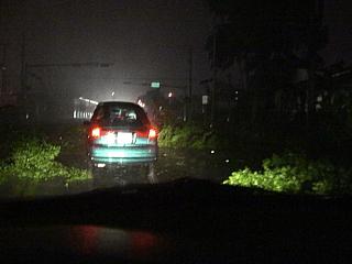
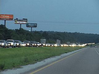
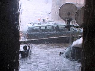
Headed west on Interstate 10, the entire eastbound lane on the other side is jammed with evacuation traffic. These people are doing the smart thing. Note that there is hardly any westbound traffic on our side. We are going INTO harm’s way, the others are going OUT OF harm’s way! Picture is by Jeff Gammons (KG4PGA). |
|
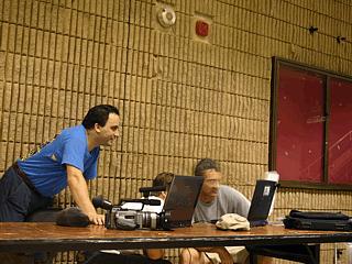
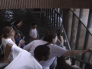
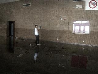
Here is a picture of myself (left) and my group of Jeff Gammons (KG4PGA) and Jim Edds (KG4TBE) checking data on the first floor / lobby of the Mississippi Gulf Coast Coliseum between Biloxi and Gulfport on the coast along Highway 90. We are preparing for the worst, which unfortunately will happen to its fullest. |
|
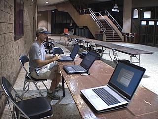
Here is another picture of our "data center" at the coliseum lobby. Make a good note of the lobby and how everything is, as it will change drastically as it gets destroyed and flooded by the storm surge later in this document. |
|
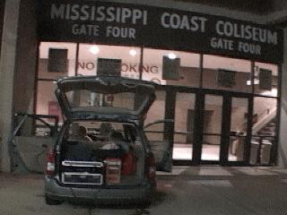
Here is a picture of the front of the coliseum entrance and lobby common area (near gate 4). We are un-packing our vehicles because we are expecting this area to flood. Chasing such a storm REQUIRES careful planning and thinking ahead to avoid "surprises". |
|
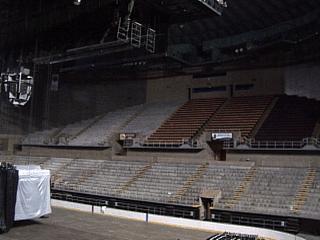
This is a view of the interior of the coliseum. Sports such as hockey, boxing, and basketball are played here as well as many concerts and conventions. Note the way it is here BEFORE the storm, so you can compare it to what happens later. |
|
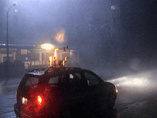
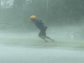
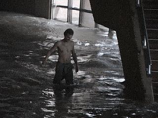
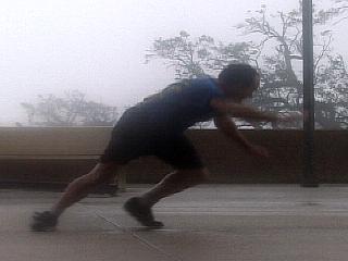
This is the arrival of hurricane forced winds during the morning of August 29, 2005. The winds here are MINIMAL hurricane forced (70 - 80 MPH), allowing one to stand in the winds as long as there is no "upwind" debris. The helmet and goggles are a MUST. Note the effects on my body! |
|
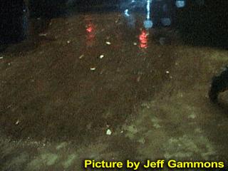
The start of the storm surge. This is the entrance to the parking lot of the arena off Highway 90. Already, storm surge is 5-10 feet above normal, and pushing a debris line landward. Picture taken in the "Surgecam II" housing for my HDR-FX1 camcorder! |
|
Here is a disturbing view of the debris line at the leading edge of the storm surge. Water is slowly rising here but winds are gusting over 100 MPH. It is now time to back away from the coast to the safety of the arena. Picture taken in the "Surgecam II" housing for my HDR-FX1 camcorder! |
|
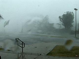
The eyewall hits. Winds gust now to 140 MPH and debris starts to fly. It gets very loud and surreal. Note the flying debris in this picture, especially to the left. The storm surge is to follow. |
|
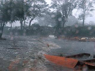
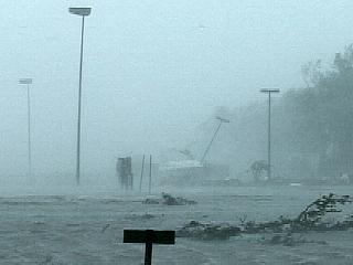
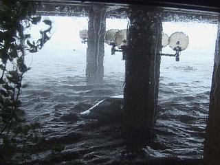
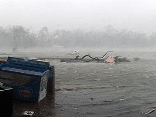
The Gulf of Mexico suddenly rises, and the parking lot floods in what is called a tidal "bore", a leading edge / wall of water from the storm surge. Yes, that is a boat moving across the parking lot and taking out the light poles! |
|
Here is another closer picture, taken be Jeff Gammons, of the same boat coming across the parking lot with the leading edge of the storm surge bore. |
|
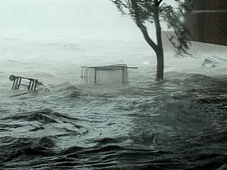
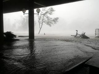
Rapidly rushing and rising salt water inundates the parking lot and flows around the rear of the coliseum and convention center. This appeared as a large wave that swept across the parking lot from the Gulf of Mexico, then spilled over the sidewalk and onto the common area in front of the lobby, which is 20 feet or so above the Gulf's normal water level! Water now is rising rapidly. |
|
It's time to retreat inside the building! Note the water rising up the glass walls and winds gusting near 150-MPH (this is a very rough estimate as I had no way of measuring them) outside. |
|
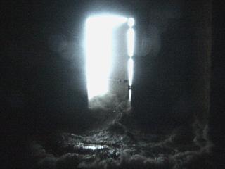
Seawater spills from an open doorway leading from the outside of the building into the playfield of the arena. This picture was taken by Jeff Gammons and shows the water from the Gulf of Mexico spilling across the concrete floor of the coliseum at anyone standing there quickly "backs off". |
|
Water rising outside pounds the steel doors and one flies open. Water pours into the first floor with violence. Note the large tree trunk entering the building through the door too! |
|
Luckily I successfully moved my vehicle up a walkway ramp, so the first surge did not sweep it away, but you will see later I did not move it high enough and have to move it again. Back inside, the glass walls on the first floor blow out, and more salt water pours into the first floor of the building. There is nothing anyone can do, nothing. |
|
The first floor and lobby are flooding fast. It is time to go to the second level of the arena lobby. Here you can see everyone going up the stairs to the second level as the first floor fills with 5 feet or so of Gulf water. These people are watching in horror as their cars are being swept away outside. |
|
Rising water outside sweeps cars away. In this picture, a floating car can be seen as trees in the foreground thrash in the wind. |
|
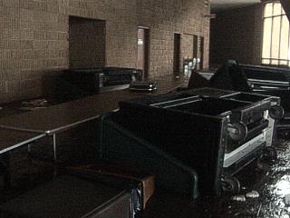
A large piece of furniture, most likely a desk from an office, floats by in the lobby on the first floor. |
|
More furniture, tables, chairs, carts, and office implements drift by and then out of site in the still rising salt water on the first floor of the arena. |
|
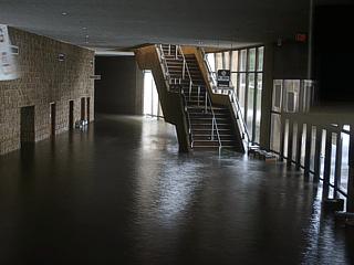
Here is a picture of the flooded lobby near high water (5 feet or so in the lobby, 25 feet or more above the gulf)! Where is all the furniture and tables? |
|
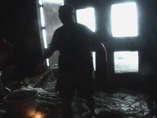
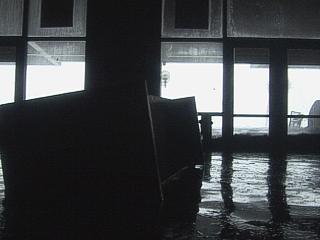
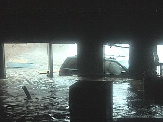
This is a picture of the main floor of the arena, stands, and playfield. At least 5 feet of water is now flooding in. The hockey rink wall is breaking apart, and the bright light you see is where the entire wall on the wind ward side of the building collapsed allowing surge and waves to enter from the outside world. Chairs are the objects floating inside the playfield. |
|
Remember the picture above with the door and water rushing in? This picture was taken as entire wall and doors were collapsing. The storm surge with 5 and 10 foot waves super imposed upon it are now free to roam into the building. Remember, this is an ENTRANCE to the arena from the lobby, looking more like a spill way from a large hydroelectric dam site! Note the "exit" signs still lit. |
|
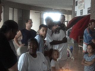
About 50 locals were evacuated to this arena because it was a very strong building, and that it was. In this picture, people wait in fear and horror just after learning many people were already killed by the storm. Here they are moving away from the window area of the second floor and seeking refuge in a reinforced concrete "bunker room". |

|
This is a picture, taken by Jeff Gammons, of terrified and grieving locals just after learning many died in the storm. The look on this woman's face will haunt me for the rest of my life. |
|
The storm surge kept rising, and after what I went through with insurance when I had my car broken into, I was not willing to explain losing my vehicle in a hurricane chase. I am exiting the broken glass door and ignoring someone screaming at me "don't go". Jeff Gammons is taking this picture. |
|
Here I am swimming and / or wading through the rising storm surge, making my way to my car and saving it just before the walkway it was on flooded. I am holding a bag containing my keys and the commissioner’s keys to keep them dry. Then I had to open both cars, the commissioner’s car ahead of mine, and moved them both farther up the ramp. Yes, this was foolish, but I was NOT going to lose my vehicle, have my car insurance deny a total-loss claim, charge up my credit card again, have to be rescued, and all that "fun stuff" - No way. Jeff Gammons took this picture. |
|
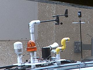
This is a picture of the "Weatherlab" weather station atop my chase vehicle safely recording data after moving the car farther up the walkway and out of the deep storm surge. |
|
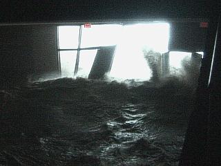
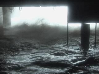
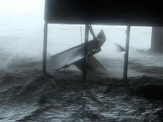
Storm surge at its highest blasting through the arena / lobby entrance. Most of the windward-facing wall is gone! Note the size of the waves INSIDE the building. The door to the right is about 8 feet high. |
|
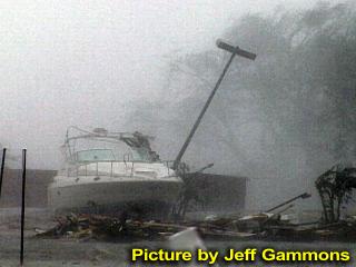
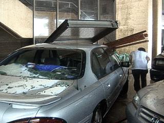
Here is a view of a car lodging into one of the entrances to the arena and going through part of the wall. The force of the storm surge and tropical cyclone waves superimposed on it was immense, and you could feel the roar of it in your chest. Note the Zamboni ice-rink resurfacer, or what's left of it, floating to the far right. |
|
A heavy steel door is no match for the power of Katrina's wind, waves, and surge. It is split in half and twisted right off with a loud "bang"! |
|
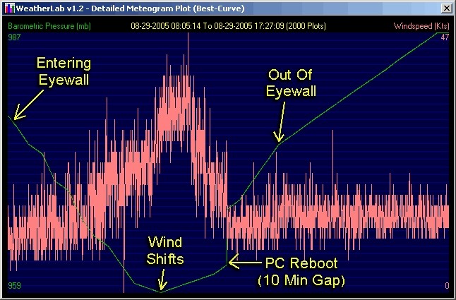
Still to the right of where hurricane Katrina's center made landfall, a brief glimpse of the extreme eastern edge of the eye of Katrina becomes visible. The wind shifts from south and southeast to south, then southwest as the eye passes. The wind let up only slightly, but as you can see in this picture, the sky gets brighter for a minute or so. Pressure was 959 MB at this point, with the 918 MB pressure "center" about 10-15 miles to our west. |
|
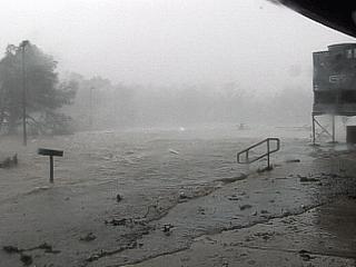
After the passage of the eye of hurricane Katrina to our west, the water suddenly begins receding since now we are no longer on the FORWARD RIGHT SIDE of the storm. The surge is still high in this picture, but is going down. Winds are still near 145-MPH in the backside of the eyewall. |
|
This young man is wading in the rising flood waters and returning upstairs after checking his car. His car was destroyed. Picture taken by Jeff Gammons. |
|
Storm surge receding a bit more, still 20 feet above the Gulf, but once again getting below the level of the first floor of the coliseum. Lots of debris and damage is left behind by the surge. Winds still near 140-MPH. |
|
Here I am amazed at how quickly the water is now receding. I am carrying my tripod and taking pictures. Note the high-water mark on the walls! |
|
In this picture we can see the water rapidly receding. Note out-flowing water from the coliseum entrance back out into the parking lot. Lots of objects can be sucked back out to sea by such a "drawdown" of water. |
|
A high water mark stains the lobby wall on the first floor of the arena and reveals how high the water went - nearly 5 feet! Remember, the floor of the lobby is at LEAST 20 feet above the Gulf of Mexico at normal sea level! Jeff Gammons (KG4PGA) is in the picture. This is the SAME place where we were all working on the computers checking data in the first pictures of this document! |
|
Winds outside on the second level are still well over hurricane force and blow me right off my feet! |
|
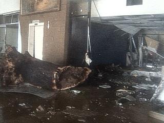
Incredible damage on the first floor on the wind-facing side of the arena in the lobby and ticketing area. This is what 10 foot waves atop a storm surge of 25 feet can do. No one staying here would have had a chance. Note the huge tree trunk carried INTO the building! |
|
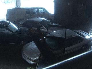
Damaged and deposited cars in front of the arena after the retreat of the storm surge viewed from inside the lobby. |
|
Same cars viewed from the outside. Note the large piece of glass wall that landed on the vehicle as Jeff Gammons cautiously ducks under it. |
|
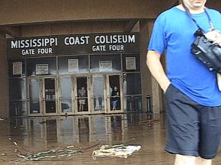
This is a picture of when the winds started to subside enough to go back out, although with extreme caution. Note the missing windows in the doors to the lobby area of gate 4 of the coliseum as dazed locals peek out. I am standing to the right, Jeff Gammons took this picture. |
|
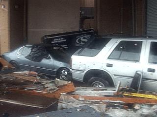
A passenger car and SUV are lodged near the loading dock area and left there after the storm surge retreated. Also note the incredible amount of debris (parts of roofs, wood, seaweed, boat parts, etc.) mixed in with the destruction. Any water flooded car cannot be sold by law in the USA, let alone damaged or destroyed in the process, so these vehicles are essentially totaled. |
|
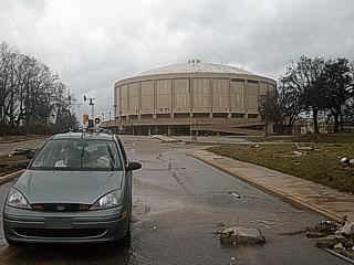
Winds in the afternoon drop to minimal tropical storm force after hours and hours of major hurricane conditions. The storm surge is also retreated to only a few feet above normal. Here is my chase vehicle and instrumentation in the foreground. The arena building is in the background and did have some roof damage but the strong steel dome held, it actually held. Note the upward slope, which the surge covered entirely earlier. |
|
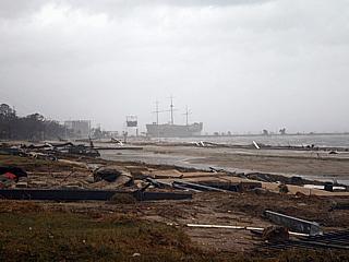
View east along highway 90 towards Biloxi, or what's left of it. No buildings along the beach exist. The large casino ship, once offshore a ways, is now on land with its bow and stern damaged. |
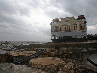
|
Here is a view west along the remnants of coastal highway 90 towards Gulfport. Note how the casino barge, anchored securely offshore the night before, crossed the beach and highway, and not stands high and dry to the right. We actually saw people picking up coins and putting them in buckets under the damaged casino but reported them as looters to the local police who were first in the area. |
|
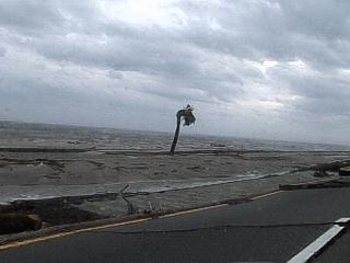
The beachfront is essentially gone after hurricane Katrina. The lone palm tree is a miracle. Also note the fractured sections of highway 90 in the foreground. |
|
Here is another and more dramatic view of the fractured sections of highway 90 after the storm. Looks more like an earthquake hit in that respect! |
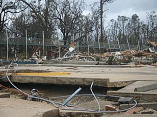
|
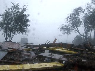
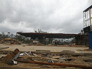
Many buildings were gutted out with only a hollow frame standing as the winds and storm surge roared straight into them from the Gulf of Mexico. Many people died in such places. |
|
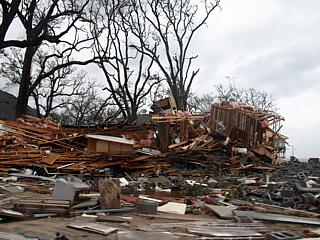
Many structures exposed to the fury of Katrina at the beach simply disintegrated. |
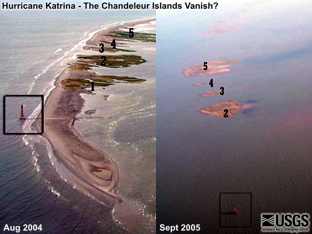
Not all geo-processes occur 'slowly' - Including changes to the Chandeleur Islands!
HTML File "kat05.htm" - Developed By Chris Collura
For a drug free workplace use instant drug testing kits like iCup drug test kit or utilize services of a drug testing laboratory.
To Return To The HOME Page Of This Site Click The "INDEX.HTM" Link Here!