
| This area shows pictures taken during and / or after various snow storms, nor' easters, blizzards, and other severe winter weather! Like their hurricane and severe thunderstorm counterparts, winter storms can also be both intense and deadly. Note: Some pictures were not taken by myself on this page, but since I have family living up north, was happy to post some pictures here for them - Enjoy! |
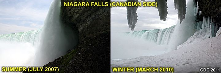
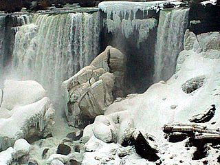
One may wonder about large waterfalls, such as Niagara Falls (New York / Canada), and can these large plunges of water ever freeze solid? Most of the time, the answer to that is "no". This is because it takes an extremely long period of very cold temperatures for that to happen to such a large mass of moving water. In the images above, Niagara (Horseshoe) Falls below Table Rock is shown from the same vantage point, one in summer (left) and the other (right) in winter. The water (reduced flow) in the winter still flows freely but the edges and sides of the falls accumulate ice (sometimes an "ice cone" develops) and there is alot of freezing spray. Smaller waterfalls, however, can freeze, and create a beautiful frozen formation called an ice grade (shown later in the next section of pictures below).
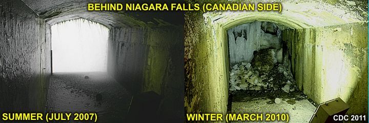
A waterfall simply does not freeze immediately, but ice builds up until the flow is slowed until it becomes completely jammed with ice. Niagara Falls is too large for this to happen during a normal winter. What does happen, however, is ice builds up in and around the plunge area of the falls, mainly from freezing spray and ice jams (from small pieces going over the falls from Lake Erie). This effect creates tremendous buildups of ice near the falls, but a complete freeze-over does not occur. In the images above, again with summer to the left and winter to the right, the "air space" behind Niagara's Horseshoe Falls becomes ice jammed, leaving the normally open and raging-wet "cataract portal" (from the "Journey Behind The Falls" scenic tunnels) ice jammed, silent, and dry during the winter!
|
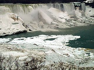
This picture was taken in early March of 2009 in Ontario, Canada and looking towards the American Falls in New York (USA). The blocks of ice near the falls, created from ice jams and freezing spray that accumulated during the past 2-3 months, are over 10 stories high! The rapidly moving water is just above freezing, and freezing occurs mostly in the places where spray freezes on surfaces and where the flow passes over rocks. The Niagara river is also jammed with flow ice in the foreground and to the left. |
|
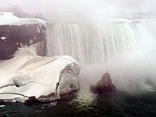
Here is a picture of the edge of Horseshoe Falls, taken from near Table Rock (on the Canadian side). The block of ice is nearly 100 feet (10 stories high) to the left. Note the pinnacle "ice berg" shaped feature to the right of the ice block. |
|
This is a close up of the American Falls in New York (USA) viewed from Canada, with torrents of water flowing past and through beautiful (and dangerous) ice formations. Note that only the rapidly moving water remains in a liquid state. The green hue of the ice is caused by tiny plants (phytoplankton) that live in the cold, fresh waters of the Great Lakes. |
|
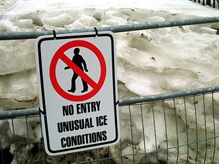
One of many warning signs posted along the walk-ways and tourist areas around Niagara Falls in the winter. The ice formations are from the freezing spray contacting buildings, trees, pavement, etc, and freezing. |
|
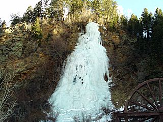
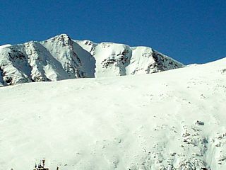
As mentioned above, small waterfalls can freeze solid forming interesting structures called ice grades. The slower moving water eventually freezes and blocks the flow to a trickle, and that finally freezes so no more water flows (entirely solid ice). Niagara Falls is simply flowing too fast and too much volume for this to happen during the winter time-frame. The ice grade shown here is near Idaho Springs in Colorado in early February 2010. |
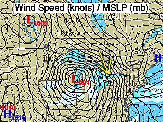
The Great Lakes area is known for some strong low pressure systems during the fall and winter months. On October 23, 2009 an intense low pressure system affected the Great Lakes area. The diagram above shows the low pressure area (centered near Chicago, Illinois). Between the low and a strong Canadian high well to its northeast (near Nova Scotia), a strong pressure gradient exists (close isobars), producing 30 to 40 MPH easterly winds (with highter gusts). The yellow arrow is my position and where the pictures in this section were taken on the western side of Lake Ontario (west of Toronto near Oakville / Burlington).
|
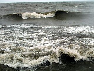
Breaking waves along the northwestern shore of Lake Ontario in a cold light rain (temperatures in the mid 40's). Winds here are over 30 MPH with waves about 5 feet high, making this look more like the ocean than a large inland lake! The view is to the SSE. |
|
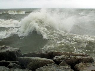
Very rough and confused wave action just east of a jetty / seawall protecting a marina and river inlet east of Oakville. Waves here are 6 to 8 feet, but with a very short wave period, and 30 to 40 MPH winds from the east / waves reflecting off the seawall is creating the spindrift. The view is to the SSE. |
|
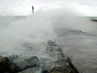
Some waves breaking and crashing into the seawall / breakwater of a river inlet east of Oakville. The view is to the south. |
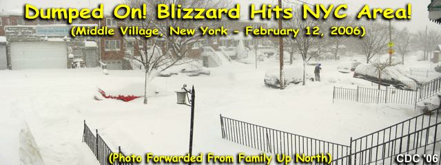
One of the worst snowstorms in history struck on February 12, 2006 in the New York Metro areas. Over 26 inches of snow fell in Central Park, New York City making this the most ever measured, therefore making this storm the worst to strike the area. The title picture above is actually a panorama taken by two cousins of mine living in Middle Village in Queens County, New York, about 5 miles east of New York City.
Here is a picture of my cousin standing in his driveway shoveling snow in Middle Village, New York. The key feature here is the unshoveled area just to the right of where he is standing, notice how high the accumulation is (over 25 inches), and this snow has not even drifted yet! My cousins, sick and tired of winter weather, retired to Florida in early 2008!
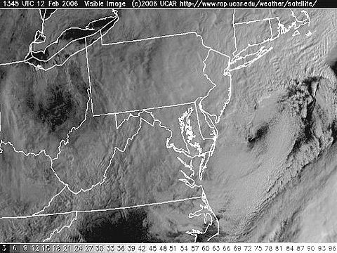
Meanwhile, well offshore, the low pressure center of the snow storm on February 12 was so intense (below 980 MB) than it developed an eye-like feature! Such snowstorms (a "blizzard" is simply a snow storm with GALE FORCED winds at or over 38-MPH) occur on the backside (NW quadrant) of the low-pressure system and can have winds approaching hurricane forced in extreme cases, sometimes even with convective thunderstorms (the blizzard on Feb 12 did have such "thundersnow"). Unlike a true tropical system, the most extreme winds and precipitation occur well away from the center, usually in the strong wind-pressure gradient between the low itself and neighboring intense high pressure (over 1020 MB). The "eye" of the storm is unmistakingly off the coasts of New Jersey and Maryland. This satellite picture was taken about the same time as the two photos above submitted by my cousins up north in Middle Village, NY.

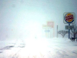
The first major snow storm of 2008 swept across the upper Midwestern US and Great Lakes region over the New Years holiday. Depending on location, some areas recived 3-6 inches of snow, such as western Illinois, while other areas, such as Michigan, received almost 20 inches! In all areas, the storm produced gale to storm-forced winds (near 50-MPH) followed by a Canadian-derived arctic airmass that advected as far south as the northern Caribbean. The snow was followed by zero degree temperatures for a few days afterwards.
|
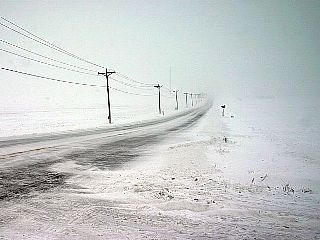
Near blizzard conditions prevail along this farm road in Northern Indiana on January 1, 2008 just west of Interstate 65. This storm crossed the upper Midwest and Great Lakes regions dumping anywhere from 6 inches to nearly 20 inches (depending on location) in a east to west oriented belt. A few days of near zero-degree temperatures followed after the storms passage. In this picture, 30-40 MPH winds are blowing and drifting the snow across the farmland. |
|
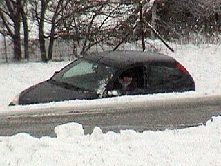
A vehicle skids off the exit ramp if Interstate 65 in Northern Indiana and winds up in a ditch on January 1, 2008. The driver was not hurt, and needed to be towed out of the ditch. |
|
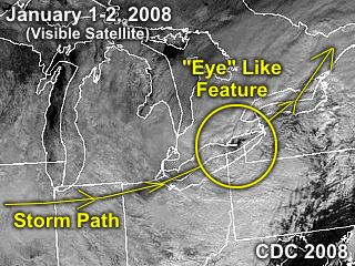
Here is a visible satellite image (annotated to show the path of the storm) of the low pressure system crossing the eastern Great Lakes late in the day on January 1, 2008. Similar to the Feburary 2006 blizzard featured earlier on this web page, an "eye" like structure is discernable over eastern lake Erie. Normally, cold-cored extratropical storms do not have true "eyes", but in extreme cases these storms can reach similar intensity (both pressure and wind wise) of their warm-cored distant tropical cousins, and may exhibit such "eye" like features near the storm center. Also unlike a tropical cyclone, these storms have their precipitation and wind on the storms periphery, and in this case, extended hundreds of miles to the west of the storm center (on the backside of the storm) in the form of heavy snowfall. |
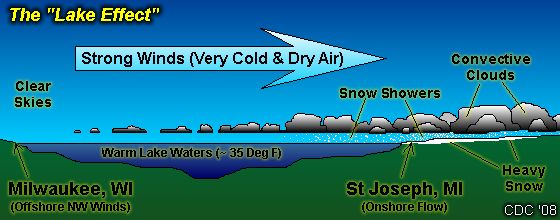
The term "Lake Effect" is used commonly on major snow events in the Great Lakes region of the United States. Simply stated, anytime a strong wind blows across a body of water, and that wind is cooler than the water is crosses, moisture is picked up by that wind. As that wind crosses to a land mass, precipitation often occurs. Often a strong wind blowing on-shore from a body of water causes moisture to be deposited. If the air is cold enough, the wind-swept showers would be in the form of heavy snow. Since the showers move over the same area in a process called "training", heavy accumulations of precipitation can result. Across the Great Lakes, especially during the winter, heavy snowfall occurs because of the lake effect. In the diagram above, a colder wind blows across the (relatively) warmer lake waters and picks up moisture. The windward side of the lake can be sunny, crystal clear, and cold while the lee side is radically different with heavy snow and strong on-shore winds! Any lee side of the Great Lakes can experience such a "lake effect" precipitation event. Buffalo, NY (downwind of lake Erie) is the most famous for extreme lake effect snows.
|
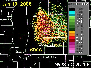
This is a radar image taken during a typical lake effect snow event. The large body of water is Lake Michigan, and a strong NW flow between a departing low-pressure system and strong arctic / Canadian high-pressure system exists over the area. This cold air, averaging 0 to 5 degrees F is blowing across Lake Michigan and interacting with the (relatively) warmer waters (aboput 35 degrees F) of the lake. The air transports the moisture to the lee side of the lake in the form of snow showers. Note the "banding" evident in the radar image. These are sometimes called "snow streamers". Lake effect snow is very notorious because it does NOT necessarily occur during a storm or low pressure. In this case, strong high pressure is present, but still the moisture advection brings heavy snow into Michigan, despite skies being clear just 60-70 miles away on the windward side of the lake near Chicago and Milwaukee! |
|
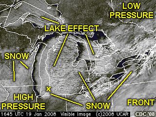
This is an annotated visible satellite image of the Great Lakes region, taken about the same time the observations in Saint Joseph, Michigan (which is marked as a small "X" on the lower eastern side of Lake Michigan). The wind flow is clearly visible, and is left to right (W and NW) in this image. Note the western side of Lake Michigan, where the cold and clear air is just blowing offshore. This area is clear, but not for long as the frigid air moves over the relatively warmer lake waters, clouds quickly develop offshore. These wind swept snow showers mature into close-cell (cold cumulus) convection, and come ashore on the eastern side of the lake. The transition from water to colder inland (land friction) causes even more snow to be dumped inland on the lee side of the lake. The white areas on the ground west of the lakes is snow on the ground from the low pressure system that has departed and is well northeast of the area. Snow from the lake effect can also be found down-wind of Lake Michigan. The clouds to the far lower-right is from a cold front, while arctic / Canadian high pressure dominates to the W and SW. Note that nearly all lee portions of the Great Lakes have the lake effect (also note the cloud "streets" and streamers), with Lake Michigan being the most dramatic on the satellite. |
|
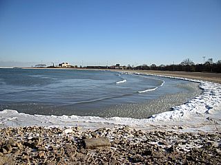
Near Chicago, IL the lake front of Lake Michigan looks like the way it always does in the dead of winter. Near calm waves, lots of ice along the waters edge, and crisp and cold Canadian high-pressure present. Temeratures here are barely above zero F. The winds are strong from the NW, and blowing offshore. The view is to the southeast. |
|
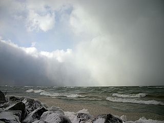
About 70 miles to the east of the last picture, conditions are MUCH different in Saint Joseph, Michigan. In this picture, snow squalls race onshore with winds gusting near 40 MPH. The waves in Lake Michigan are at least 5-6 feet in height, with blowing, freezing spray. Although warmer than the wind-ward side of the lake, the temperatures are still cold, around 10-15 degrees F. |
|
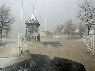
Definitely not a good day to go to the beach ... In Saint Jospeh, Michigan, frigid strong on-shore NW gales blow sand and snow into drifts near the beachfront park. This is a good description of a "frozen tropical storm". |
|
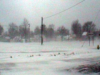
On the lee side of Lake Michigan, near Saint Joseph and northward, snow accumulations ranged from 6 to 12 inches, with blowing and drifting snow. Again, a far cry from clear and sunny skies 60-70 miles across the lake to the west. |
|
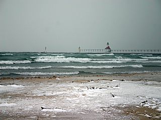
Here is a picture of the waves in Lake Michigan near the Saint Joseph River inlet in Michigan. Waves were at least 6-8 feet in strong NW winds (30-35 MPH). |
|
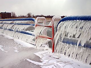
Here is a picture of some interesting ice accumulations on the railing that runs along the jetty at the mouth of the Saint Joseph River that enters Lake Michigan. Freezing spray coats everything in ice, and becomes a major hazard to any boat traffic that may be on th water in such conditions. |
|
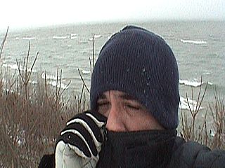
This is myself braving the extreme cold near Saint Joseph, Michigan. Temperatures are about 5 to 10 degrees F, with a 30 MPH+ NW wind. Wind chills are 15 to 25 BELOW zero ... A far cry from the balmy, tropical "paradise" of Florida. In such cold, any exposed skin is subject to severe frostbite. The little "crack" in my face is all that was exposed. The key is "layering" your clothing. Underwear, topped with thermal full-length underwear, shirt, sweater, full down coat with winter hat, jeans, winter pants atop the jeans, ski gloves, boots, 2 socks - You still freeze your butt off! |
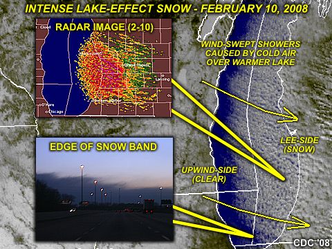
Another much-more powerful lake-effect event took place during the late-night and early morning from February 9-10 along the eastern side of Lake Michigan. This event was in the wake of a powerful "Alberta Clipper" type cold front that moved quickly across the Great Lakes region. Arctic high pressure in the wake of this storm setup a strong pressure gradient, and stiff northwest winds across the area. Temperatures ranged from -10 to +5 degrees F in this cold airmass. The transit of this extremely cold air across the warmer lake waters (about 32-35 degrees F) caused heavy snow on the downwind side of the lake, accompanied by gale to even storm-forced winds. All the while, skies remained cold, sunny, and clear on the upwind side of the lake! In the diagram above, a composite of annotated satellite and radar imagery is shown during the peak of the storm. The lower-left inset, looking NE from Indiana, shows the conditions just outside the lake effect, taken at dawn with clear and very cold conditions. The low cloud edge is the start of the lake-effect snow bands that appear in the radar / satellite imagery.
|
Here is another lake effect storm affecting the area near Saint Joseph, Michigan on February 10, 2008. This included winds near 50-MPH with whiteout / blizzard conditions during the morning. |
|
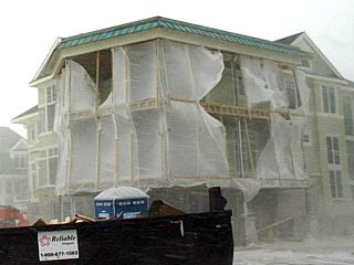
A lake-front home under construction in Saint Joseph, Michigan takes on some damage during the morning of February 10, 2008. Winds off Lake Michigan were gusting over 50-MPH with heavy lake-effect snow. |
|
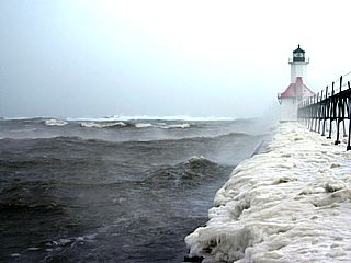
Here is a picture of the mouth of the Saint Joseph river, and north-jetty light during the winter storm. The waves were as high as 15 feet - In a "lake"! Note the "steam" rising off the 35 degree water into the 5 degree air, as well as breaking waves as far out as you can see. |
|
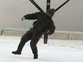
This is a picture of myself leaning and struggling in the 50-MPH wind gusts at the inlet to the Saint Joseph river in Michigan. Reminded me so much of hurricane and tropical storm chasing, where you get "blasted" by the winds in a similar way. I would describe this as a "frozen hurricane", where the frigid wind literally chills you to the bone, despite layers of clothing. The wind was strong enough to push you along the ice, and freezing spray from the lake quickly covered my hat, coat, and pants with an ice coat. |
|
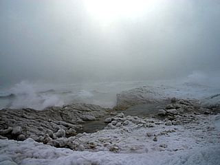
Here is a view of the beachfront just north of the Saint Joseph river jetty during the storm. Yes, this is a beach, but it is covered with large chunks of fractured lake pack-ice and frozen spray heaps. Huge waves are breaking and crashing into the lake-ward face of the ice, sending freezing spray many feet into the air. This was a sight to behold, looking more like a scene from an frozen alien planet than the shore of the US Great Lakes! |
|
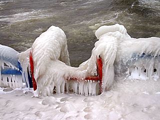
Freezing spray is a very dangrous hazard to ships and vessels that happen to be on the water in such conditions. This spray freezes instantly, especially when contacting metal surfaces, creating a thick and artistic coat of ice. In this picture, the railings, jetty, and boat access ladder are covered in this ice. Any boat or vessel taking on such ice can sink and / or be capsized from the extra weight, and must be constantly chipped off. |
|
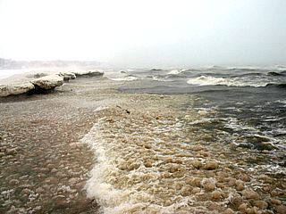
This is picture of the beachfront on the south side of the jetty at Saint Joseph, Michigan. The water takes on a "green sea" look due to the agitated state of the water, kicking up sand and silt, as well as some algae that normally flows into Lake Michigan from the Saint Joseph River, which was also at flood stage at the time. The surf zone is loaded with floating ice, slush, and large breaking waves. Note the notched ice front to the left along the frozen beach, which created an ice "bluff" over 20 feet high in some areas. |
|
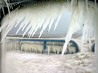
Here is another picture taken through an opening in a railing and looking out showing the artistic nature of the ice accretion due to heavy freezing spray. The iceicles are oriented with the flow of the strong, frigid winds. |
|
A large, breaking wave impacts the jetty along the north side of the Saint Joseph river inlet during the early morning of February 10, 2008. |
|
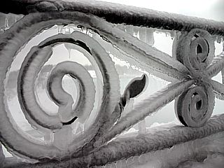
Here is a picture of a railing near Table Rock (Canadian side of Niagara Falls) in March of 2011. Freezing spray has coated and froze to the iron-work of the fence forming a beautiful ice formation. Freezing spray is dangerous because it accumulates on trees, buildings, powerlines, etc and can cause them to collapse. Also, freezing spray on a ship or boat can add tons of "top heavy" weight to it causing it to capsize / sink if it is not laboriously knocked off by crew (usually with rubber mallets). |
|
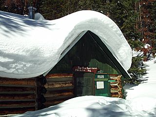
A small log cabin from an abandoned gold mine in the back-country of the Colorado Rockies still stands with many feet of snow on its roof. Snowfall in the mountains is often measured in FEET rather than INCHES. Note the front entrance / door covered half-way up by the deep snow on the ground. Elevation is about 10,500 feet above sea level. |
|
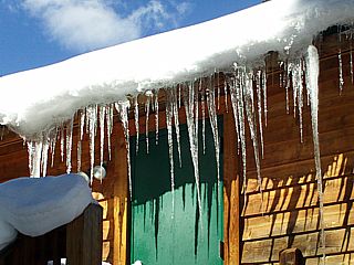
Here is a picture of some iceicles hanging down from a roof of a ski / snow mobiling lodge near Breckenridge, Colorado in February 2008. |
|
At high elevations, winter takes on a polar climate, where little plant life (trees) grow and it snows every month of the year. This is picture of the Continental Divide in Colorado (near Breckenridge) in mid February 2008. The sky is clear with strong sunlight at high altitudes (near 13,000 feet) but with temperatures from 0 to 10 degrees. |
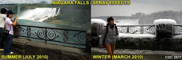
Winter weather can transform any landscape into something radically different than that same place in the summer / warmer months. In the image above, one can make out such a difference between summer (left) and winter (right) of the edge of the Niagara Falls gorge / Table Rock area on the Canadian side of Niagara falls. Note the freezing spray covering the rocks and railings, truly a winter "wonderland".
|
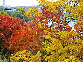
Here is a picture taken of the colors of the trees in Ontario, Canada in Niagara Falls in the fall (late October) of 2009. This is along the Canadian side of the Niagara River. |
|
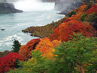
Here is another picture taken of the colors of the trees as well as Horseshoe Falls in the fall of 2009. |
|
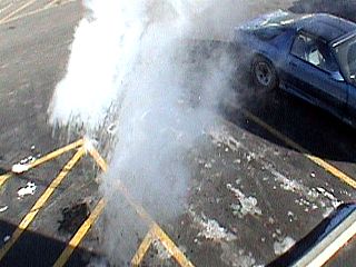
Here is an interesting effect that occurs when you toss a cup of very hot water into a frigid air environment. The water in this picture is being tossed off the second floor of a motel near Chicago into a parking lot in January 2008 with temperatures about -5 below F. The hot water vaporizes and sublimes into ice crystals before reaching the ground with a rather spectacular cloud of steam. This happens because of the rapid phase changes (steam to liquid to ice) of the water being tossed into the air. This effect only works in extremely cold weather. |
|
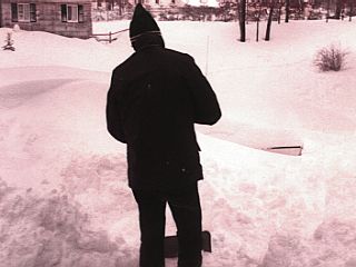
The infamous blizzard of 1978 experienced first hand as I was a child in Ronkonkoma, New York on Long Island. This is a picture of my father shoveling the heavy snow from the front door, just so we can get out. The driveway was another story, the 1977 Cadillac is completely covered except for its rear bumper in the right of the picture. This storm brought 90 MPH winds to New England and snow totals of 3 to 4 feet. These extratropical storms can have winds as strong as their distant tropical cousins, hurricanes. |
|
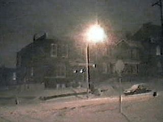
Here is a picture taken at night during a major winter storm in Saint Louis, Missouri in January 1996. Winds here are also gusting over 30 MPH with blowing and drifting snow up to about 15 inches accumulation. |
|
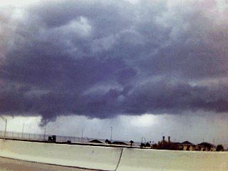
Much farther south, in the warm air across Central Florida, the same storm system that produced the February 12, 2006 blizzard in New England brings a cold front through the deep south. In this picture, the ominous roll cloud appears on the leading edge of the strong and sharp cold front as it surges through Orlando, Florida. Winds to 50 MPH were observed in a narrow line of showers as this front passed through, followed later by temperatures in the upper 20's during the night. |
|
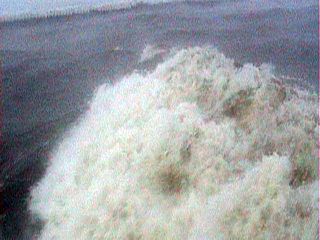
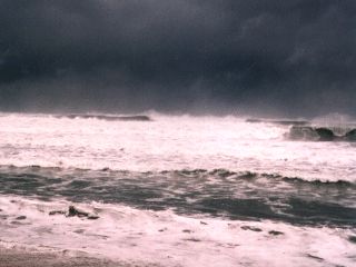
Winter storms do not only cause snow and ice, they also kick up tremendous waves and swell if the strong winds blow across a long fetch of water. In this picture, an intense winter storm (a nor' easter) is off the southeastern United States over the Atlantic Ocean. The heavy precipitation (snow) is not near any coast, but winds over 60 MPH are offshore over a large area. Waves near 20 feet, generated by the storm, reach Palm beach, Florisa, where this picture was taken (March of 1996). |
|
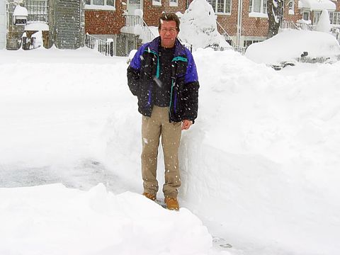
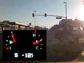
Bitter cold weather prevails in Aurora, Colorado (a suburb southeast of Denver) on February 18, 2006. Temperatures here are about -12 below (Farenheit temperature, not a wind-chill). Earlier that night / morning, Fort Morgan, Colorado reached -19 below. |
|
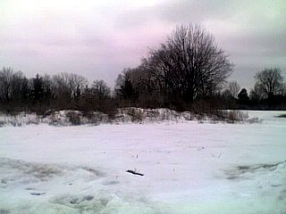
Snow still covers the ground in Dayton, Ohio in late February 2007 after an intense snow storm affected the region. Snow still covered the ground in these areas until early to mid March before melting. |
|
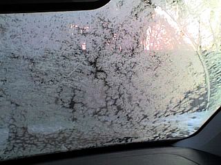
Everyone who deals with winter weather enjoys the morning ritual of scraping ice off their cars! Here is a picture of "jack frosts" work on my car windshield on a cold morning in late February 2007 in Dayton, Ohio. |
|
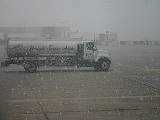
Here is a picture of some moderate to heavy late-season snow falling in Early April 2007 at Wright Brothers (or Dayton) International Airport in Dayton, Ohio. This was during a painfully delayed flight from Dayton, Ohio to Dallas, Texas that left over 2 hours late and caused me to miss an connection! Snow is a nightmare for air travelers. |
HTML File "winter.htm" - Developed By Chris Collura
To Return To The HOME Page Of This Site Click The "INDEX.HTM" Link Here!