
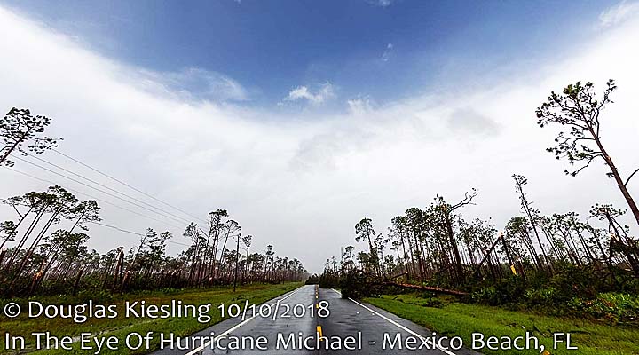
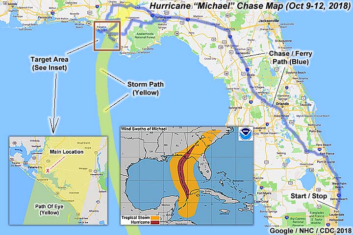
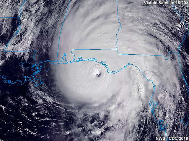
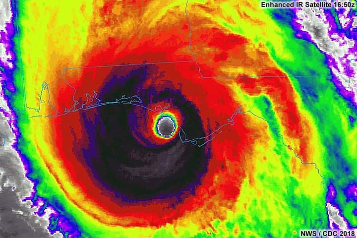
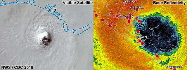
| This area shows pictures taken from the interception and observation of extremely devastating and catastrophic category-five hurricane Michael in the Florida Panhandle east of Panama City including its landfall on October 10. This devastating storm originated as a tropical disturbance in the western Caribbean sea off the Central American coast during the latter part of the first week in October 2018. This disturbance drifted northward over the next few days forming a tropical depression east of the Yucatan Peninsula of Mexico and subsequently tropical storm Michael near or over the western tip of Cuba around October 6 and 7. Michael continued north-northwest, then north, while intensifying steadily over the southern and eastern Gulf of Mexico, becoming a hurricane on October 8. Continuing north, the storm began rapidly intensifying - Maintaining that trend up to and including landfall between Mexico Beach and Tyndall Air Force base to the east of Panama City, Florida during the early afternoon of October 10 as a category five hurricane, with sustained winds of 160 MPH and a central pressure of 919 mb. Only three category 5 hurricanes struck the mainland USA in previous history, none of which in the month of October, before this one. The storm began moving north and northeast, causing devastation well inland, crossing the I-10 corridor later that afternoon with 130 MPH winds. By October 11, the storm accelerated northeast, weakening to a tropical storm over Georgia and South Carolina. By October 12, Michael raced off the NE USA and became extratropical that same day. My interception of this storm was not for the faint of heart. I left south Florida on October 9, heading up the Turnpike to Ocala, then I-75 to I-10, and west into Tallahassee for that evening. The following day, October 10, I left Tallahassee very early to meet up with other chasers and the primary target area near and east of Panama City. The base area there was a Holiday Inn Express, in Springfield, FL east of Panama City and north of Tyndall Air Force base. I met up with chasers Derek Sibley and Tim Millar there as well. Many other chasers were also in and around the area, including Josh Morgerman and his film crew, Jason Foster, Brett Adair, and Mark Robinson to the west. Before the storm came in, Derek, Tim, and myself went to Panama City Beach - But decided to back track to Springfield at the last minute as the storm eye was the main target, which was trending east. After a quick check of Tyndall AFB, we basically "rode out" then violent northern eyewall of the storm during the noon and afternoon at the Holiday Inn Express off Highway 22. Damage was catastrophic, with winds gusting at LEAST 160 MPH, and much of the hotel's front and covering disintegrated burying / damaging my vehicle and many others under rubble. The western side of the calm eye was observed, with NE winds rapidly shifting from NE to NW. The conditions inside the eye were warm and sunny, partly cloudy and clear to the east. The eyewall presented a rare and spectacular "stadium" effect seen more from hurricane hunter aircraft than observers on the ground! Conditions around the eye and eyewall were similar - There was simply NO weak side to this storm, and a solid ring of violent thunderstorms (tops to 60,000 feet) surrounded the calm (and clear) eye at landfall. After the second part of the storm calmed down, I continued helping locals with moving debris and clearing the vehicles that were buried. I cleared my vehicle (heavily damaged but driveable) and used the winch to move heavier material. I also helped with transporting some of the locals there, including a woman who was devastated about damage to the paper mill there. Josh Morgerman and his group spoke to my group, and we decided to stay the night there using our provisions, avoiding a mandatory curfew until 8 AM on October 11. On the 11th, we left the hotel and worked our way north and northeast towards I-10, with unimaginable traffic and delays. It took over 10 hours just to reach Tallahassee. Once past there, I continued east on I-10 to I-75, then south back across Florida using the Turnpike and I-95, reaching my home back in Deerfield Beach just after midnight on October 12 with a total mileage on the vehicle (2016 Jeep Wrangler) of 1264 miles. Note - This page may take a while to load on some SLOWER connections! |
| CHASER NAME | HOME CITY | CALLSIGN | OCCUPATION |
| CHRIS COLLURA | DEERFIELD BEACH, FL | KG4PJN | COMPUTER CONSULTANT |
| DEREK SIBLEY | HOLLYWOOD, FL | N/A | METEOROLOGIST |
| TIM MILLAR | LAKE WORTH, FL | N/A | PILOT |
|
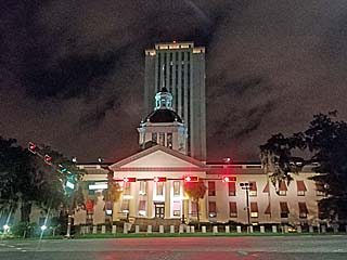
View of Florida's state capitol building while departing Tallahassee early before dawn on October 10, 2018. My trip began with leaving south Florida on the 9th and heading up to the Florida Panhandle, spending the first night in Tallahassee. In this picture, I'm leaving and heading west to the primary target near Panama City, FL - Which is close to the landfall point. |
|
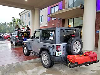
My vehicle and a few others east of Panama City at the Holiday Inn Express east of Panama City (in Calloway, FL) during the morning of October 10. Meteorologist Tim Millar's vehicle is in front of mine (the Jeep Wrangler). Turns out this area is close to "ground zero" as the storm comes in later and much of this area will experience total devastation. |
|
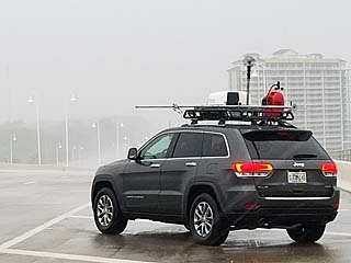
Meteorologist Tim Millar's chase vehicle on the Highway 98 causeway between Panama City and Panama City Beach. We are checking out that area for possible chase options / parking garages. Tim is calibrating the roof-top radar in this picture. |
|
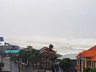
View of Panama City Beach from a parking structure showing the tremendous hurricane surf in the Gulf of Mexico. The storm eye will actually pass east of this area, putting it under the left / western eyewall. |
|
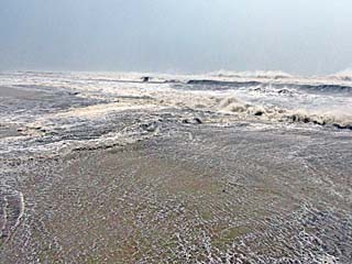
Large waves and surge along the beach in Panama City Beach before heading back east. |
|
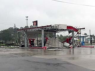
Texaco gas station suffering damage as the first hurricane forced wind gusts affect Long Point (near Calloway and Springfield, FL) while re-positioning back east of Panama City. |
|
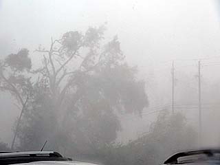
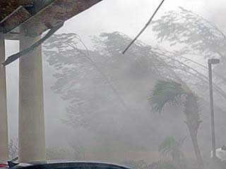
First eyewall winds, now well above hurricane forced and gusting over 100 MPH, downing trees on the southeast side of the Holiday Inn Express in Calloway, FL off Highways 98 and 22. |
|
Eyewall winds increase and approach gusts over 130 MPH, flattening trees and starting to damage the entrance roof to the Holiday Inn Express in Calloway. |
|
Ceiling panels falling off and being blown away from the entrance roof to the Holiday Inn Express. |
|
Holiday Inn Express front entrance roof beginning to catastrophically fail. Winds approaching 160 MPH gusts around noon on October 10. |
|
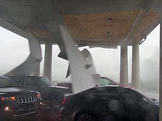
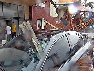
Holiday Inn Express front entrance roof is practically gone in inner eyewall winds - Gusting 160 to 180 MPH. Cars - Including our chase vehicles are buried in the rubble. |
|
View of damage vehicles as we near entrance to the calm eye of hurricane Michael during the afternoon of October 10. Note the vehicle impaled through the driver's side windshield with heavy lumber! |
|
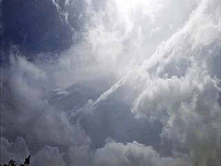
We entered the western sections of the calm eye - With light winds and partly cloudy skies at our location. Looking up in this picture, the 60,000 foot eyewall edge stretches across the upper right with the bright sun overhead and blues skies! The calm lasted roughly 10 to 15 minutes. |
|
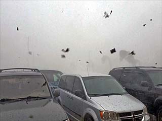
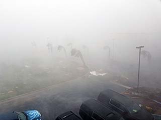
The second half of the eyewall of Michael strikes with a vengeance - With 150 to 160 MPH winds from the opposite direction after passage of the eye. Here the winds are out of the northwest (opposed to ENE and NE before the eye) as the backside of the hurricane passes, with zero visibility and flying debris once again. |
|
Debris flying by and strong winds gusting over 150 MPH on the backside of hurricane Michael under the eyewall. |
|
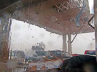
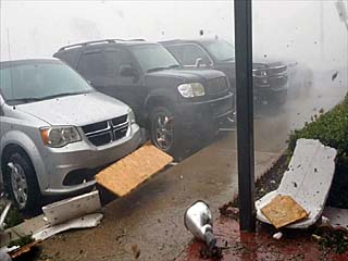
View out of broken window looking southwest across the entrance to the Holiday Inn Express and Highway 22 as the eyewall of hurricane Michael continues to rake the area. |
|
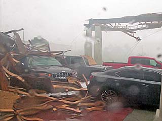
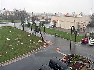
Same view as the picture above, once out of the zero-visibility eyewall and visibility improves - Revealing utter destruction of most structures. |
|
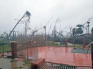
View looking northeast near the pool area of the Holiday Inn Express with most trees destroyed and the ones remaining stripped of leaves and branches. |
|
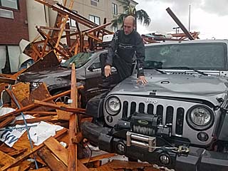
Tim Millar climbing over his vehicle - Buried in rubble, and next to my vehicle after the winds die down below hurricane forced. |
|
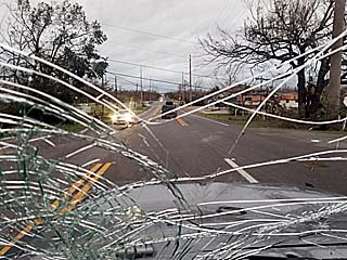
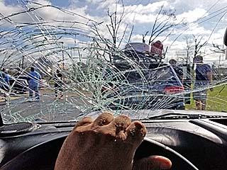
View of Highway 22 through my shattered windshield while taking a local to check on damage at her factory (a paper mill) a few miles up the road. |
|
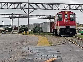
Derailed / flipped cars on a train at the paper mill southwest of Calloway late on October 10. Every box car behind the prime mover (locomotive) is tipped over from right to left. |
|
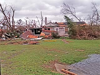
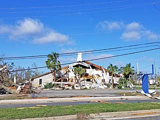
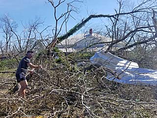
One of many destroyed residences and stripped trees near Calloway, FL late on October 10. |
|
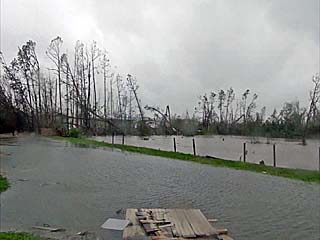
Fresh water flash flooding on the north side of the Calloway Holiday Inn Express. |
|
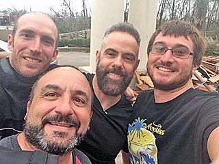
My immediate storm chasing group for the storm, among others. From left to right: Meteorologist Tim Millar, myself, Josh Morgerman (iCyclone), and Meteorologist Derek Sibley. |
|
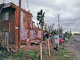
One of many devastated apartments across the street (Highway 22) from the hotel before sunset on October 10. This was a gruesome and sad sight. Many people here are in shock, dazed and confused on what happened to their city just hours prior. |
|
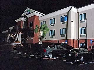
View of our hotel, the Holiday Inn Express, along Highway 22 in near total darkness (our spotlights illuminating the damaged front entrance) just before midnight on October 10. I spent about an hour speaking to some locals under the Milky Way of stars, watching a rescue helicopter piercing the darkness from time to time. |
|
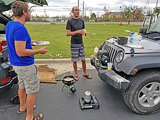
Breakfast in the south parking lot the following morning of October 11, 2018. Derek Sibley, Tim Millar, and myself are enjoying hot coffee and breakfast using our portable stoves and provisions. In a disaster like this - You need to bring stuff WITH YOU. |
|
Leaving Calloway early on October 11, after the curfew was lifted at 8 AM (anyone caught on the streets during the night would be arrested). Driving was difficult with my windshield shattered and many roads blocked with debris. |
|
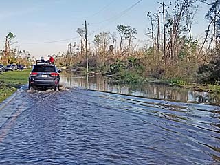
More severe street flooding and stripped trees to the north of Calloway, Florida while leaving on October 11. |
|
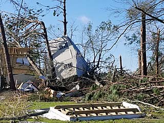
Mobile home tossed upside-down and destroyed among other destroyed structures and stripped vegetation north of Calloway, Florida. |
|
Destroyed church north of Calloway, Florida near Highway 98. |
|
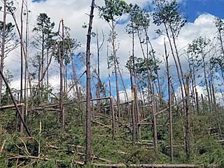
Tree debris and damage blocking the roadway near Youngestown, Florida along Highway 231. This stopped our northeastward progression - Causing us to back-track west to near Highway 77. Note the completely stripped and defoliated trees (looking like trees in winter up north). |
|
Numerous trees snapped and stripped well inland to west of Tallahassee near Marianna, Florida and along Interstate 10. Damage extended far inland northeast of the landfall point, causing I-10 to be blocked and / or closed for many hours. |
|
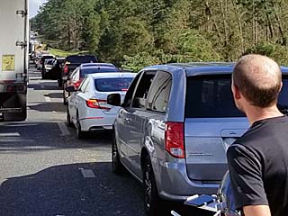
Traffic heading eastbound on I-10 was at a standstill due to debris and trees blocking the road west of Marianna, Florida. Chaser Tim Millar is to the right. |
|
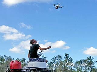
Tim Millar flying his drone over the traffic jam to get footage and / or see whats going on up ahead. Eventually we moved and made it back to south Florida by around midnight / early morning on October 12. |
HTML File "mike18.htm" - Developed By Chris Collura
To Return To The HOME Page Of This Site Click The "INDEX.HTM" Link Here!