
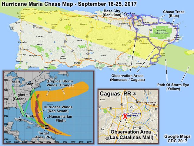
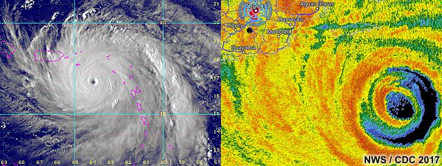
| This area shows pictures taken from the interception and observation of powerful category-four (borderline 5) hurricane Maria in southeastern Puerto Rico from its landfall on September 19 and 20, and subsequent destruction and aftermath. Hurricane Maria was a deadly and powerful hurricane that made its way across the Atlantic from the Cape Verde Islands off Africa in the middle of September 2017. East of the windward islands, it quickly intensified, and reached category 5 strength, with 160-165 MPH winds, and struck Dominica during the night of September 18. After devastating the islands, it continued WNW towards Saint Croix and Puerto Rico a day later, reaching a staggering 175 MPH as it approached Puerto Rico. Eyewall replacement and concentric eyewalls caused the storm to weaken a bit, but widen to a larger storm with 155-160 MPH winds as it made landfall just before dawn near El Negro, Puerto Rico on September 20. The storm ripped across the island in a diagonal path, from southeast to northwest, exiting northwestern Puerto Rico as a strong category 3 storm with 120 MPH winds early on the 21st. After striking Puerto Rico and clearing the Island, the storm went back out to see to the north of Hispaniola and brushed the Turks and Caicos Islands around the 22nd. The storm began moving northward, and passed east of the Bahamas and US East coast from the 23rd onward. Continued weakening occurred to east of the USA coast, and became a tropical storm late on the 26th (or early 27th) of september. Moving slowly, but eventually recurving out to sea, Maria continued weakening and became extra-tropical, ending its week and a half rampage across the western Atlantic. For me, this chase started with me flying from Miami to San Juan, Puerto Rico late in the day on September 18 (after cutting short a vacation in Chicago, which was supposed to last until the 21st). On the 19th and the 20th, I headed out of San Juan and rounded the east coast of Puerto Rico, ultimately winding up near El Negro and Palmas Del Mar. I headed back a bit to Humacao, then settled in Caguas for the main part of the storm and eye. After that, I headed back to San Juan once conditions permitted, reaching that area late on the 20th. I spent the remainder of my stay with storm chasers Brett Adair, Brandon Clement, and Caleb Eliott at their hotel (Condado Vanderbilt), which had food, water, and generator power. With flights cancelled, including my return on the 22nd, I eventually made it out of there on an unscheduled humanitarian flight with Brett and Caleb to Newark, New Jersey late in the day on September 24. Brett Adair wound up leaving this flight in a medical emergency (possible kidney stone), as I spend the night in New York with a friend, and finally made it back to Fort Lauderdale, Florida late on September 25. The total mileage on the rental car was about 150 miles, left with minor damage at the airport after being unable to find the off-airport return location in flooding, blocked roads, and no cell service. Power may be out in many areas in Puerto Rico for six months. Hurricane Maria was the worst storm to hit the island in 85 years. Note - This page may take a while to load on some SLOWER connections! |
| CHASER NAME | HOME CITY | CALLSIGN | OCCUPATION |
| CHRIS COLLURA | DEERFIELD BEACH, FL | KG4PJN | COMPUTER CONSULTANT |
|
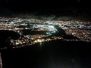
View flying into San Juan on a late night flight on September 18, 2017. |
|
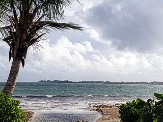
The calm before the storm! This is the beach area near Carolina, Puerto Rico before the storm on September 19. |
|
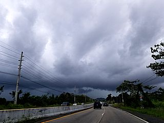
An outer convective feeder band pushes from east to west near Highway 3 in northeastern Puerto Rico late in the day near Luquillo on September 19. |
|
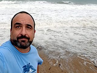
Picture of myself near the coast of El Negro during the late afternoon of September 19. The raging hurricane surf behind me has breaking waves 10 to 15 feet high, with hurricane Maria churning in that direction. |
|
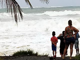
Locals in El Negro watching the crashing hurricane surf. Large southeast swell, radiating out and ahead of hurricane Maria, reaches the normally docile shores of southeastern Puerto Rico long before the storm arrives. This was near and just south of the main landfall point near Palmas Del Mar. |
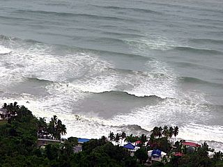
|
Tremendous waves and southeast swell impacting the coast, viewed looking down from a high cliff near El Negro during the evening of September 19. |
|
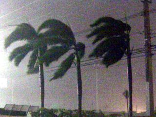
Arrival of hurricane forced winds before dawn on September 20 in Caguas, Puerto Rico (a small city inland from Humacao and Palmas Del Mar). |
|
Trees blowing down as the hurricane winds up in Caguas, Puerto Rico on the morning of September 20. |
|
Trees being blown flat during the first eyewall of hurricane Maria in Caguas, Puerto Rico, viewed from a parking garage at the Las Catalinas Mall. |
|
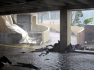
View of roof fragments, trees, and debris slamming the entrance of the parking garage of the Las Catalinas Mall in Caguas, Puerto Rico during the morning of September 20. |
|
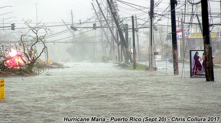
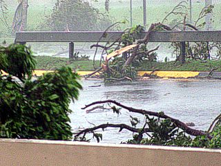
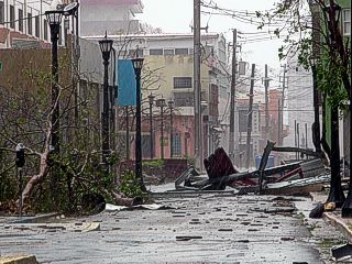
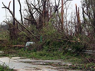
View along a street in Caguas, Puerto Rico during the late morning of September 20. |
|
Debris and structural damage of Highway 1 through Caguas, Puerto Rico during the late morning of September 20. Note the stripped trees on the mountain in the background! |
|
Collapsed wall and part of a cemetary in Caguas on September 20. |
|
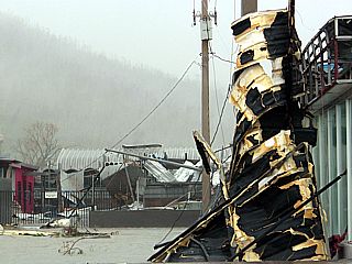
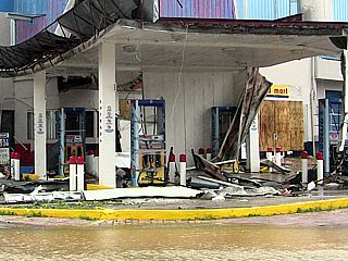
Destroyed gas station in in Caguas on September 20. Most buildings that survived structurally were made of reinforced concrete. |
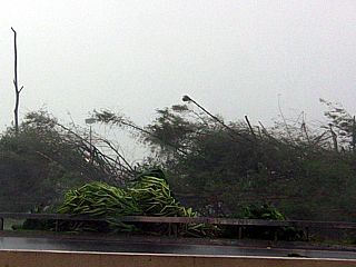
|
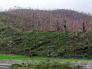
View of mountain that was stripped of trees and vegetation north of Caguas, Puerto Rico during the late afternoon of September 20 west of Highway 52. |
|
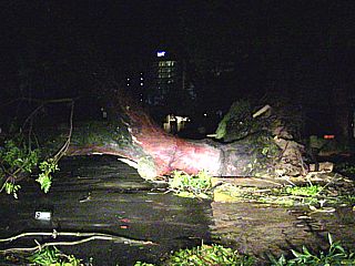
Vehicle "buried" in fallen trees along Highway 52 between Caguas and San Juan late in the day on September 20. |
|
Making the journey from Caguas to San Juan was long and arduous on September 20. Two attempts (first one failed) were made to get out of Caguas, negociating flooding, downed trees, and many roads blocked by debris. Here a large tree blocks the roadway coming into San Juan during the evening of September 20. |
|
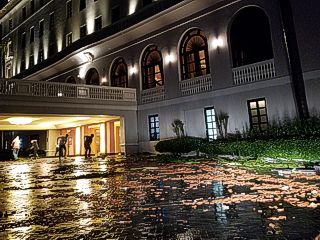
This is the front of the Condado Vanderbilt Hotel in San Juan, right after the storm, during the late evening of September 20. This hotel was a "saving grace" for myself, and a "base" for meeting up with three other storm chasers: Brett Adair, Caleb Elliott, and Branden Clement. These folks were nice enough to let me stay with them until we got out of Puerto Rico. The debris (glass and roofing tile fragments) is littering the front entrance, but power is on thanks to generators. Food and water were available to guests in this hotel (while they lasted), along with security. |
|
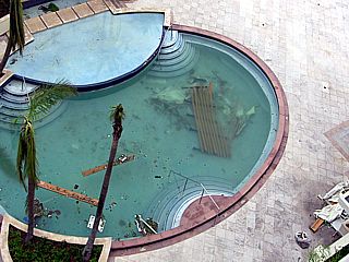
Part of a roof and debris littering the pool and pool area during the morning of September 21 at the Condado Vanderbilt Hotel in San Juan. |
|
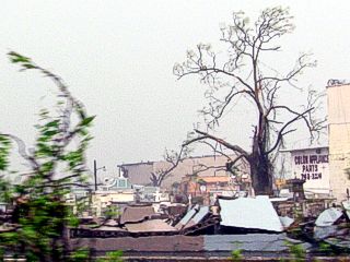
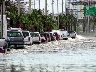
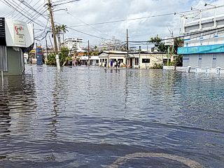
Days after the hurricane, many roads remained impassible. This is the Roman Baldorioty De Castro Expressway (Highway 26) looking east out of San Juan towards Carolina on September 22. Severe flooding is still in progress. |
|
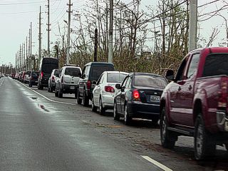
With a developing humanitarian crisis, and no places to get fuel, gas lines became literally MILES long. This one is near Luquillo, Puerto Rico during a failed attempt to make it towards Fajardo to meet the US Coast Guard. Pretty much all communication and electrical infrastructure was destroyed at this point. My flight back to Florida was supposed to be this day (September 22), and to no surprise, that was cancelled indefinitely. |
|
Impassible roads and severe neighborhood flooding near and along Highway 3 into San Juan near Atlantic View on September 22. Blocked roads made for a trecherous and frustrating re-route all the way around Highways 26 and 17 westward with almost no fuel left. |
|
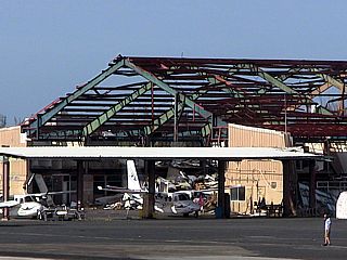
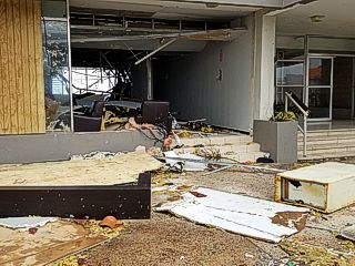
One of many hangars damaged at the San Juan (Luis Muńoz Marín) international airport on September 22. |
|
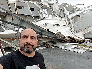
Damage at a hangar with myself standing in front of it at the Isla Grande airport in San Juan late in the day on September 22. |
|
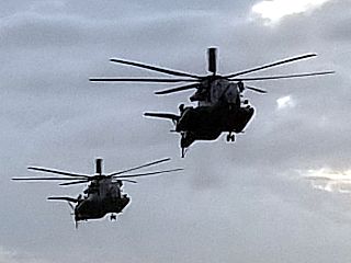
Two Sikorsky "Sea Stallion" helicopters with the US Marines land at the Isla Grande airport late in the evening of September 22. This was part of a long string of military aide missions. |
|
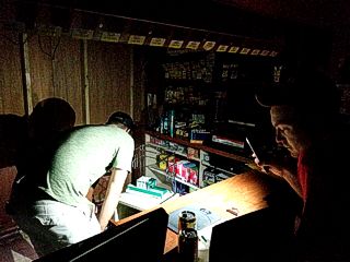
Inside a damaged convenience / grocery store without power near the hotel in San Juan, after the 6 PM curfew on September 22, as we pick up some supplies. The owner began charging two (or even three) times the amount for food / drinks. |
|
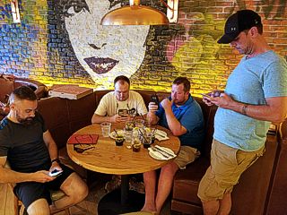
Here is a group of storm chasers eating at a restaurant (with power) on September 23. From left to right: Josh Morgerman (iCyclone), Brett Adair (Weather Nation), Brandon Clement, and Caleb Elliott. A small pizza at this place costed at least $25, at another Meditarranean restaurant nearby, 4 chicken platters with rice costed nearly $200! As gas became unavailable, it was bartered and sold (sometimes by cartels) for 4 to 5 times the regular price, even siphoned from boats. |
|
Structural damage to one of the hotels in San Juan on September 23. |
|
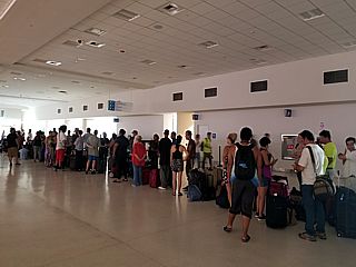
One of the long lines at the San Juan (Luis Muńoz Marín) international airport on September 24. There was absolutely NO online or booking - You just had to show up, and WAIT for many hours (in deplorable smell, heat, and humidity), and HOPE you got on an un-scheduled humanitarian flight out of there. |
|
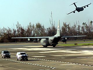
Composite image of two planes, a C-130 taxiing, and a C-5 Galaxy taking off. This was while leaving San Juan (Luis Muńoz Marín) international airport on September 24 via a long-awaited humanitarian flight to New York / New Jersey. Brett Adair and Caleb Elliott also got on this flight out, with Brett suffering from a kidney stone just prior to landing in Newark. Thank God he didn't get sick hours earlier! |
|
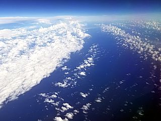
Looking eastward off the North Carolina coastline, and finally heading home to Florida on September 25, the inmistakable view of hurricane Maria looms over the horizon, with banding in the foreground. |
HTML File "maria17.htm" - Developed By Chris Collura
To Return To The HOME Page Of This Site Click The "INDEX.HTM" Link Here!