
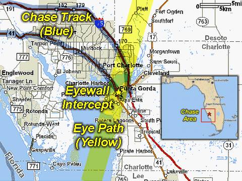
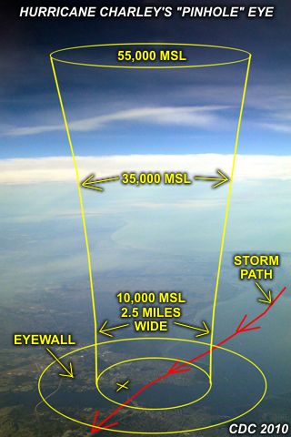
| This area shows pictures taken from the observations of major and devastationg category-four hurricane Charley in Southwest Florida in Charlotte County. The storm, originally a tropical disturbance that moved off Africa, formed in the Carribean, crossed Cuba, and moved into the extreme southeastern Gulf Of Mexico. On Friday, August 13, 2004 it moved NNE past Key West and slammed into Sanibel Island then Punta Gorda just after explosive intensification to 145 MPH sustained winds with gusts over 175 MPH and a central pressure of 941 MB with an eye only 6 miles across. This hurricane interception began on the forward-right quadrant of the hurricane and involved eyewall then eye penetration in a solid structure, the Criminal Justice Courthouse of Charlotte County. Most of Punta Gorda was dessimated by the storm. This chase observation was also conducted with the former "Weathervine" storm intercept team, BNVN founder Doug Kiesling, and several other storm chasers. The chase lasted from about 5:30 PM August 12 to 3 AM August 14 (actual hurricane chase was August 13), with about 522 total miles logged! Note - This page may take a while to load on some SLOWER connections! |
| CHASER NAME | HOME CITY | CALLSIGN | OCCUPATION |
| CHRIS COLLURA | MIRAMAR, FL | KG4PJN | COMPUTER ANALYST |
| DOUG KIESLING | MINNEAPOLIS, MN | N/A | BNVN PRESIDENT |
| JASON FOSTER | BALTIMORE, MD | N3PRZ | ARCHITECT |
| JEFF GAMMONS | WPB, FL | KG4PGA | PHOTOGRAPHER |
The participants below are not from the former "Weathervine", SKY-CHASER, or BNVN chase team(s) but did actively participate in our storm research efforts and deserve appreciation for their great help and severe weather expertise.
| CHASER NAME | HOME CITY | CALLSIGN | OCCUPATION |
| JIM EDDS | FLORIDA KEYS | KG4TBE | PHOTOGRAPHER |
| MARK RACKLEY | FLORIDA KEYS | N/A | DIVE INSTRUCTER |
![]() Read "Hurricane Charley - A Hurricane Chaser's Perspective"
Read "Hurricane Charley - A Hurricane Chaser's Perspective"

The full-DVD "director's cut" version of the hurricane Charley documentary won the "Best Documentary" award at the Miami International Independent Film Festival seen in February 2005 ... Be sure to check out this video (or view the clip sampler below)!
![]() Hurricane Charley 2004 (Team Effort - DVD Production)
Hurricane Charley 2004 (Team Effort - DVD Production)
![]() Hurricane Charley Video
Hurricane Charley Video
|
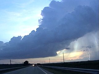
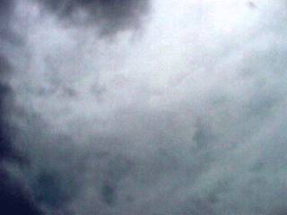
This is a low-topped mini LP supercell like cumulonimbus after leaving Okeechobee, FL while headed west on highway 70 east of Arcadia on August 12. The approaching hurricane and its wind-field creates speed and directional shear in the atmosphere, making conditions favorble for rotating thunderstorms and eventually tornadoes in the forward-right side of the storm. The cell here did have some shallow rotation. Also note the high cirrus "marginal area" clouds to the left which are the first ahead of the hurricane. The view is to the west. |
|
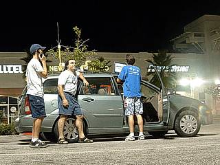
The primary target area was the Sarasota and Bradenton areas. In this picture, we are at a parking lot in Bradenton checking data and trying to find a hotel for the night of August 12. From left to right is Jeff Gammons (KG4PJN) on his cell phone, myself, and Jason Foster (N3PRZ) on the laptop computer. The chase vehicle, a Ford Focus Station Wagon, is ready to sample a hurricane with the modified "Weatherlab III" on its roof. Evacuations and emergency procedures made finding accomodations nearly impossible. We are on the internet in this picture, by the way, courtesy of Sprint PCS. |
|
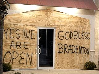
Despite the impending hurricane, few people boarded up their businesses. The store here was the only one borded up in the Bradenton strip mall. The hurricane at the time was a category 2 storm with 105 MPH winds. |
|
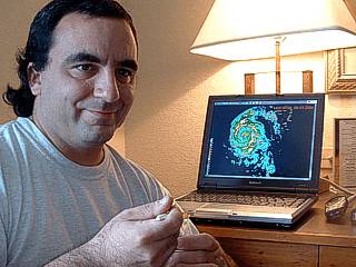
Here is a picture of myself in a Sarasota Best Western checking data over some chicken soup right from the can. The laptop computer shows clearly the approaching hurricane bearing down on SW Florida. This was the morning of Friday, August 13, and the hurricane was currently 110 MPH and strengthening. |
|
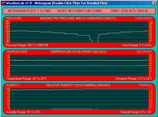
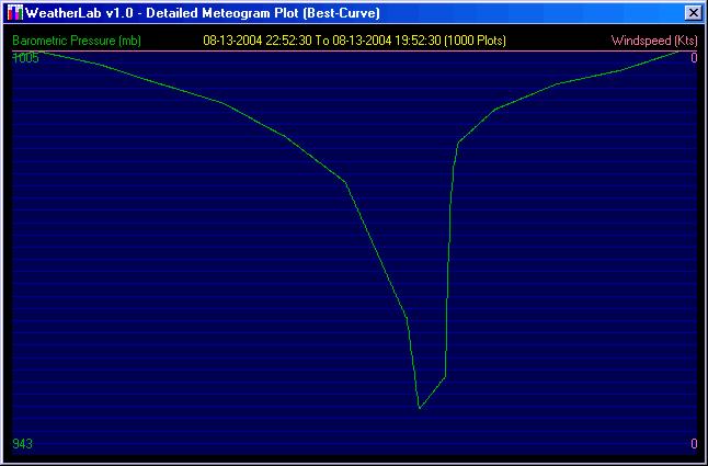
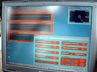
Here the laptop computer is running and receiving data from the "Weatherlab III" weather station mounted atop the chase vehicle. The system is ready to record the winds, pressure, and temperatures in hurricane Charley - barometric pressure being the most important. |
|
Headed southward towards Fort Meyers on Highway 41, the sky grows ominous as we draw closer to the storm. This was about the same time we heard that Charley undergone "explosive deepening" and now was a 145 MPH category 4 hurricane! The sheriff in the foreground is headed back for shelter from a patrol and will not be able to help anyone until AFTER the storm. |
|
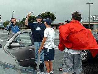
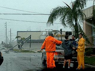
We reach Punta Gorda, Florida and stop to meet up with Jim Edds (KG4TBE - far left), Mark Rackley (not in this picture), and Doug Kiesling (BNVN - Weather Channel). We are talking in a parking lot trying to figure the "safest" place and method to observe 145+ MPH winds only an hour or so away. Punta Gorda was in the direct path of the storm. Jeff Gammons and Jason Foster are to the center and right. |
|
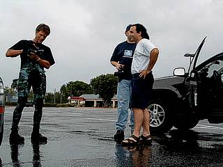
Here is another picture of Mark Rackley (left), Doug Kiesling, and myself in Punta Gorda off highway 41 mulling over options as Mark shows some equipment. |
|
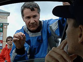
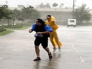
Jim Edds with his serious "get ready for a BIG hurricane face" talking to Jeff Gammons about chase options for a storm that is literally too dangerous to even chase. Jason Foster is in the background with the orange raincoat. |
|
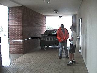
This is a breezway / enclave on the west side of the Charlotte County Criminal Justice building. This was the safest place we could find to protect our vehicles, not to mention our lives, from the storm. The building was re-inforced concrete and brick construction that respected the new hurricane building codes. The key word here is that this is the "safest" place, not "safe", because debris and winds still were to tear through the structure during the height of the storm. Doug Kiesling and Jeff Gammons are in front of a Jeep Cherokee SUV rental (Doug's vehicle). |
|
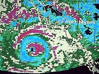
This is a radar image to behold. Taken from my chase vehicle just before the hurricane eyewall of Charley came ashore to our south and southwest. The black screen is no rain and blue is light rain, then green, yellow, and red for the heaviest. The key feature in the radar image is a DOUBLE EYEWALL. This is where two concentric eyewalls form, where a large red broken circle (outer eyewall) surrounds a tight red inner "doughnut" (inner eyewall). Note that only blue (light rains) constitute the space (usually referred to as a "moat") between the eyewalls. Double eyewalls are very rare, and only exist in the most severe hurricanes. Note the tiny "eye" in the center of the inner eyewall! |
|
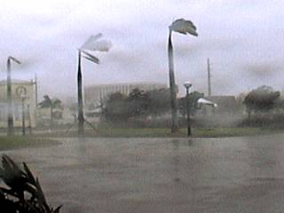
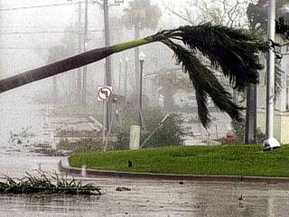
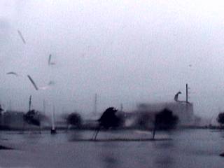
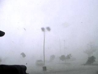
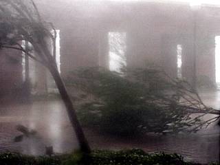
During the start of the hurricane forced winds in the outer eyewall of Charley, trees bend and debris starts to fly as winds gust to about 100 MPH. In this picture, an airborn piece if debris can be seen just to the right of the light post under the right-most large palm tree. Winds here (view is looking SSW) are from the southeast. |
|
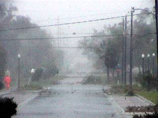
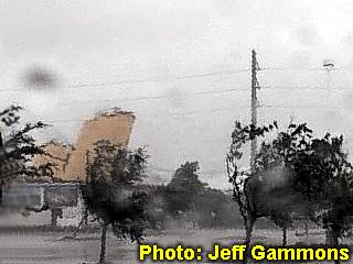
A street south of the Charlotte County Criminal Justice Building becomes strewn with tree debris and powerlines during the first half of Charley's eyewall. The black specks in the air are roof tiles flying! |
|
A large royal palm tree crashes down as 100 MPH southeasterly winds prevail ahead of hurricane Charley's core. Note the debris in the neighboring street. |
|
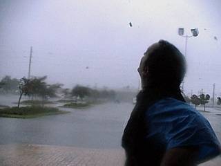
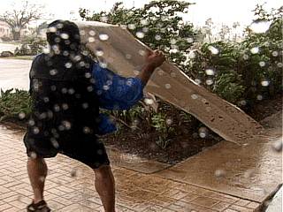
Jason Foster braves the brute wind gusts preceding the arrival of Charley's eyewall as he films the storm through a video camera in a protective housing. Water became a major problem with camera equipment in this storm. |
|
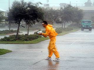
Here is another picture of Jason Foster after getting knocked over by the winds. Keep in mind that we are NOT in the eyewall winds yet, which were far too dangerous to stand in. Winds here are barely hurricane forced (about 75 MPH in gusts). |
|
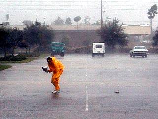
Here is a picture Jason Foster and myself being blasted by 75 MPH wind gusts as Charley moves in. Note Jason's feet have left the ground! |
|
This is a self-picture of myself standing on the west side of the Criminal Justice Building just as the inner eyewall moved in. Winds here INSTANTLY went from about 75 MPH to over 120 MPH and you started to feel the ground shaking! Note the large pieces of debris flying through the air as I stare at the eyewall with my own eyes. |
|
As the inner eyewall of hurricane Charley moves in, the air literally becomes filled with all kinds of debris. In this picture, a sheet metal roof was ripped off a building by a 130+ MPH wind gust. The roof subsequently disintegrated in mid-air and produced a shower of jagged sheet metal fragments (to the left). Also note the large roof tarp hitting the power poles to the right. The speed of the debris was blurring and it was cringing to imagine what would happen if someone got hit with it. |
|
Here is a video frame-grab, from video by chaser Jeff Gammons, of a roof completely airborne across the street (Nesbitt) from the Criminal Justice Building. The entire roof is nearly vertical in the left side of the picture exposing the plywood underside of the roof as it is ripped off its trusses. This roof crashed down so hard you could feel the "thud" in your chest. |
|
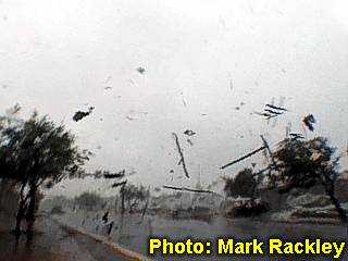
Seconds after the above picture was taken, Mark Rackley around the corner of Nesbitt near the US Post Office, captures debris from the same roof flying through the air with his video camera. Image is frame grab from Mark Rackley's video. |
|
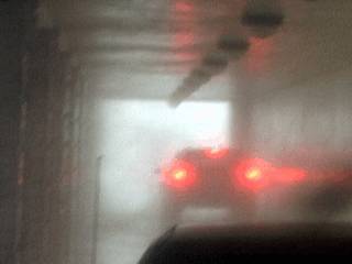
Finally the inner eyewall is upon us and visibility drops to zero as a debris-filled 145 MPH sustained wind with gusts to over 175 MPH blasts us with the force of a large tornado! Pressure pops your ears and you can feel the rumbling (resembling that famous "freight train" sound) in your chest. I cannot describe how LOUD this was. I was hanging on to the railing (even the railing was physically shaking) and trying to get sucked out into the eyewall winds. |
|
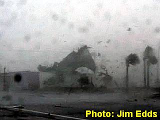
Here is another roof being ripped off a large building across the street from the Bank Of America Building. The roof is being "peeled" off from left to right in 150+ MPH southeast winds under Charley's inner eyewall. Jim Edds, took this video shot (frame grabbed from video) while praying. |
|
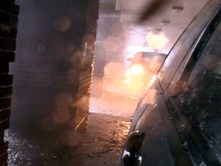
Debris and violent sideways rain and spray climax at over 150 MPH as the sky turns suddenly brighter because we are only a mile or so from the eye and eyewall boundary. Large debris and wreckage is still airborne and I was actually praying as I was taking this picture "God, take care of all of us". |
|
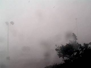
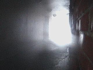
The aircraft-velocity winds suddenly die down as if a switch was thrown on the storm ... We are in the eye! The eye of this storm was one of the smallest ever seen, less that 5 miles (officially 2.5 miles) wide when over land. This is the view at the EYEWALL of the storm. You should be able to make out the light is coming from the top of the picture. The view is right at the WALL of the cylinder of clouds around us. Note the "helical structure" barely visible to the center and right of the picture. The view is to the west on the eastern edge of the eye. Winds have decreased to only 40 MPH. |
|
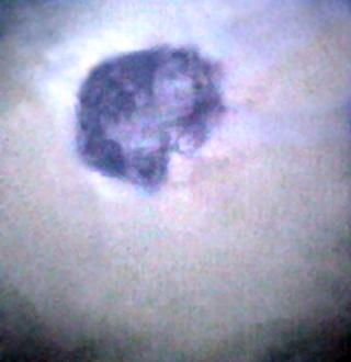
With winds briefly letting up to 30-40 MPH, I run outside and shoot video straight up. This is the eye of hurricane Charley. Note the circlular patch of blue sky surrounded by the eyewall (half covered by the building). This eye was small, about twice as high as its width, more like being in a "tube" than a "stadium". Note the light shining off the left side of the eyewall in the picture just left of the blue area. The weaker winds only lasted a few minutes. |
|
Here is another view of the same shot above, taken by Jason Foster (N3PRZ) with a wide-angle lens. Note the eye (blue sky) and "fishbowl" (eyewall) surrounding it. |
|
While still in the calmer weather in the eye, I move a piece of sheet metal debris from the back of Doug Kiesling's rental SUV and toss it into the parking lot. The return winds only picked it up and slammed it into another car! |
|
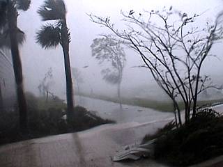
The second half of the storm was simply a return to 145 MPH winds with higher gusts but from the OPPOSITE direction they were before, from the northwest. Here trees get knocked over and more debris pummeling takes place. |
|
Here is a picture down the enclave of the justice building's west side as the backside of the eyewall slams us. The SUV near the end of the tunnel is Doug Kiesling's Jeep Cherokee SUV rental. The winds nearly ripped the hood off his car and ripped the bumpers from Jason Foster's Chevy S-10 (foreground)! |
|
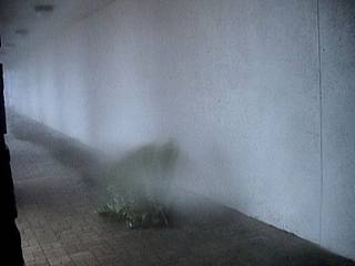
This is another picture of the tunnel during the backside of Charley's eyewall. We later called this the "pressure-cleaning car wash" tunnel. I was currently trapped in the eastern tunnel on the opposite side of the building as I got caught offguard by the on-slaught of the storm's second half. |
|
This picture was my version of the second half of hurricane Charley's eyewall. When the second half of the storm hit, I was literally sucked into the east tunnel of the building, falling and scraping my hand and leg. I managed to pin myself on the wall between columns as winds near 130 MPH shot metal, glass, trees, and other debris through the tunnel. Here I had to stay for about 15 minutes until the eyewall passed. I could have died here if it was not for my quick thinking (and praying). Note the tree whizzing by in this picture. |
|
Here is another picture towards the opening of the hallway / tunnel where I was trapped just before my camera quit from the moisture. Note the water and debris (sheet metal) being forced into the opening! |
|
Here is a view on the eastern side of the justice building during the second half of the eyewall. Lots of roof material landed in this area and trees were damaged. My video camera quit after this from water intrusion. |
|
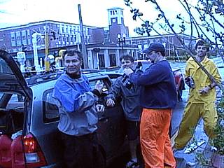
We are still here! Just after the worst part of the hurricane passed, and with my video camera finally working again, we left the Charlotte County Criminal Justice Building and went across the street to meet up with Jim Edds and Mark Rackley, who was speaking with some locals at a demolished street-side bar. In this picture, Doug Kiesling, Jim Edds, Jason Foster, and Jeff Gammons exchange experiences on what just happened around them. |
|
Here is another picture of Doug Kiesling, Jim Edds, Jason Foster, and Jeff Gammons discussing damage assessment and options after the storm. The large building with the LEAST damage anywhere in Punta Gorda is in the background: The Charlotte County Criminal Justice Building, and it was under this building where most of us took shelter during the eye wall of hurricane Charley. Built to new strict building codes, the building faired the best and was one of the only standing after the storm! |
|
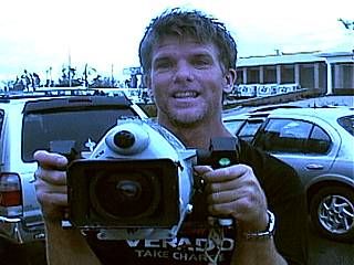
Mark Rackley, still on a MAJOR adrenaline "high", films me with his underwater-housed diving camera while saying "Was that insane or what?". This man filmed the disaster as it was happening while hiding on the lee-wind side of a street tree planter. His footage is so extreme that it makes any disaster movie look like nothing! |
|
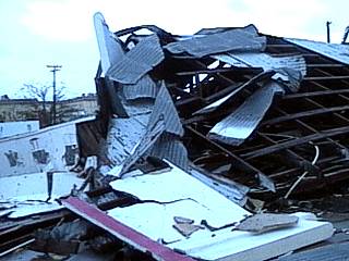
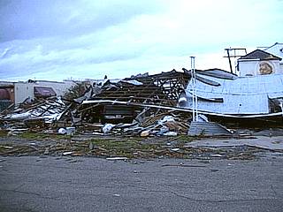
Catastophic roof failure occurred on this Punta Gorda business off Highway 41 an hour or so after the winds from Hurricane Charley moved off to our northeast. This was one of many structures totally demolished by the hurricane eyewall winds earlier. |
|
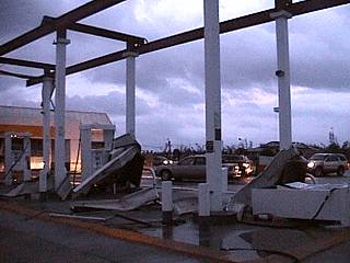
A service station canopy lost its roof during the hurricane off Interstate 75 in Punta Gorda, Florida. The convenience store was completely exposed but local police did a great job at keeping looting to a minimum. |
|
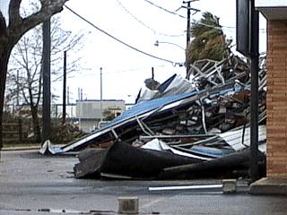
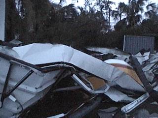
More roof debris in a street off Highway 41 in Punta Gorda. |
|
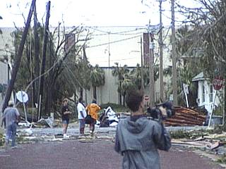
This view up the street shows tree debris and powerlines strewn across the road. The building at the end of the street had moderate damage but its northern wall is intact (reinforced concrete). Jeff Gammons is in the foreground as residents assess the damage in a daze in the background. |
|
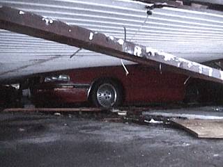
Here is the view under a collapsed building, most likely a body shop. Luckily, no one was trapped under this, after we yelled under the wreckage and no-one answered. Note the half flattened red car! |
|
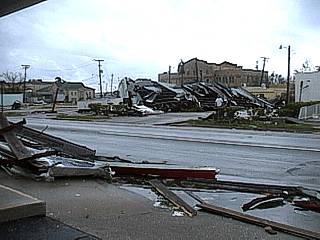
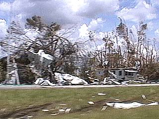
This picture shows the view to the southwest near Highway 41 in Punta Gorda. Most wood framed structures were completely demolished. Only brick and concrete reinforced structures remained. |
|
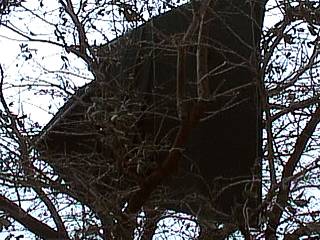
Here is a picture of a large piece of sheet metal hung up in a tree across the street from where we were during the storm. Lots of debris and building implements were carried high through the air and came to rest in such bizarre places. |
|
More debris piling and wreckage along Olympia Blvd east of highway 41 near the Punta Gorda post office and criminal justice building. |
|
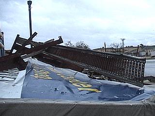
This is a picture of the remnants of a billboard sign (Best Western hotels) that was destroyed by the eyewall winds of Charley. These signs are supported by a huge steel post, which was simply crushed like a beer can! |
|
Here is another view of the Punta Gorda body shop off Highway 41 which completely failed during the maximum hurricane conditions. Many cars underneath were crushed or flattened. Note the pickup truck. |
|
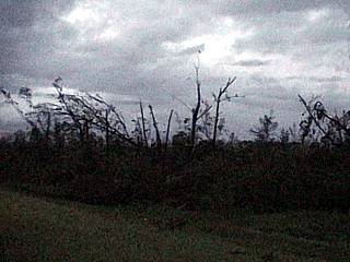
This is what was left of a thick forest along Interstate 75 after hurricane Charley blew through. Most tall trees were destroyed, making you able to see the horizon through the remaining stumps. Very reminescent of hurricane Andrew back in 1992. |
|
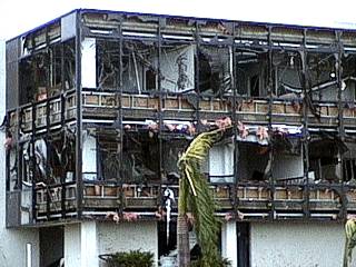
This office building in Punta Gorda was not designed up to the new hurricane building codes. As you can see, every single window was blown out and damage was extensive. The reinforced concrete held, but the building was completely gutted out by the wind and debris buffeting. |
|
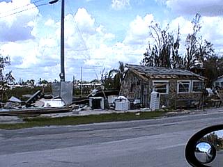
This is a portion of a mobile home park off Highway 17 northeast of Punta Gorda. The building destroyed was part of a gas station and boat dock. The mobile home park was totally dessimated by the storm. |
|
Here is a disintegrated mobile home park off Highway 17 northeast of Punta Gorda. Unfortunately, people were killed by the storm during hurricane Charley. This picture shows the grim remains of the community and debris (sheet metal) lying everywhere. |
|
More damage in a gas station off Interstate 75 in Punta Gorda. The building and canopy remnants were piled against trees and a dumpster on the northwest side of the property. |
|
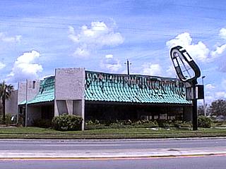
Forty miles inland, in Arcadia, Florida, damage still was extensive. Here a "Clock" restaurant was heavily damaged, losing its windows and sign. |
|
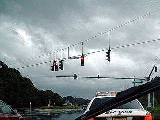
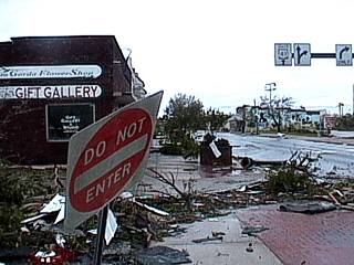
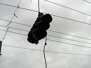
A traffic light dangles by a thread over a Punta Gorda intersection after Charley's wrath. So many signs were down that you were only able to navigate using GPS. |
|
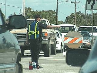
With street signs and traffic signals down, police directed traffic and limited access to the disaster area(s) on major roadways into and out of the Punta Gorda area. The Army National Guard was also called in to help. |
|
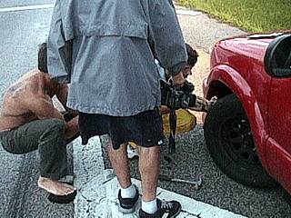
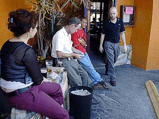
One problem was that after a major disaster like hurricane Charley, lots of small tire-punching debris (nails, splinters, glass, etc) remained in the streets. Jason Foster got a nail in his front tire and is shown here plugging it as Mark Rackley and Jim Edds watch. We did not forget to bring out tire patch and plug kits to make such repairs as well as a can of fix-a-flat to inflate and seal tire leaks! Duct tape also came in handy for covering holes in windows on some chase vehicles. |
|
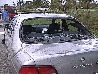
The flat tire was one thing, but this is a picture of fellow hurricane chaser, Jim Edd's car after the storm. A large piece of roof debris slammed into it, despite the car being parked in a relatively "lower wind" area, and did $7,000 dollars worth of damage (total loss). Luckily, Jim was not in his vehicle during the height of the storm. Jim Edds is the man standing to the upper-left. |
|
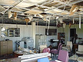
This is a picture of the inside of a small office building off Highway 41 near olympia that was demolished by hurricane Charley. This picture was taken about three months after the storm. Note the caved-in ceiling tiles. |
|
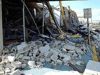
The true power of hurricane Charley's winds became apparent to this unfortunate store front off Olympia in Punta Gorda. The entire cinder-block corner on the south side of the strip mall was completely destroyed (catastrophic curtainwall-type failure). Note that there is both rubble from concrete blocks and even reinforced concrete as well as a complete collapse of the roof above the store fronts. The view is to the north. |
|
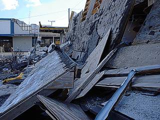
This is another picture of the same store fronts where the roof collapsed in front of them. Note the damaged facade on the store front in tha background. The view is to the south. |
|
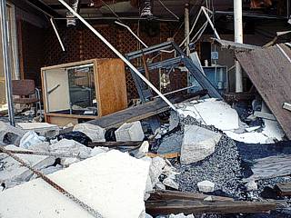
As anyone could imagine, anyone unlucky enough to be in such a structure during the storm would probably have had very little chance of surviving. All these buildings are damaged well beyone repair and were scheduled for demolition at the time. The store front here was facing east, into the prevailing eyewall winds of the storm's first half. |
|
Cleanup continues for many structures, even three months later. This building along the Peace River is being repaired but debris has been piled up awaiting removal in the rear parking area. |
|
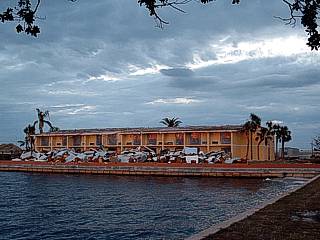
Owner and employees of the hard-hit Celtic Ray Irish Pub near Nesbit on Marion Avenue in Punta Gorda take a break on the east side of the building. The owner, kevin (man in the center with the white shirt) just got his establishment running smoothly three months or so after the storm. Some procedes of our DVD sales went into helping this establishment stay open (the City of Punta Gorda wants the building demolished). About 75 percent of the building, except for the bar area, suffered extensive damage. |
|
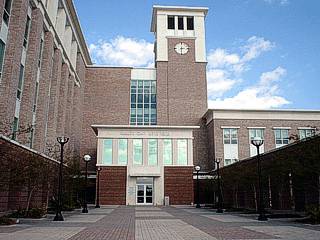
Here is a picture of the main entrance and courtyard area of the Charlotte County Criminal Justice Building. Built and engineered to withstand a violent hurricane, the reinforced brick and concrete structure suffered only minor cosmetic-type damage (lights down, some windows damaged, and AC units dmaged). This building literally kept myself and some my chase team alive through the worst of the storm! The view is to the east at the clock tower. |
|
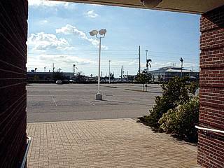
This is a picture of where myself and most members of my chase team were standing as the 150 MPH winds blasted us. However, in this picture, the scene is much, much different - With sunshine, blue skies, and light winds (try comparing this shot to some of the pictures taken in the same place during the eyewall above). It is so hard for one to imagine how a violent hurricane like Charley turned the very air we breathe into something so destructive. |
|
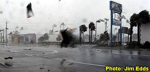
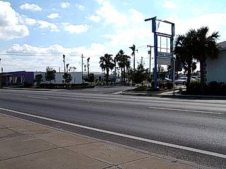
Here is a fair-day shot from the now famous location Jim Edds was during the height of the storm. The view is to the south and west. Compare this scene with the eyewall scenes (including the banner image at the start of this document) above. The building to the far left still has no roof, and is scheduled to be demolished. The sign in the center is awaiting replacement and the building to the far right already has a new roof. Again, the weather in this picture here is radically different (in a good sense) than the other pictures! |
|
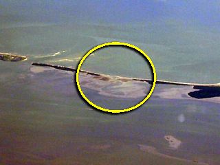
This is a zoomed-in and enhanced picture, looking southwest, taken from an MD-80 commercial airliner flying at high altitude (31,000 feet) over Arcadia, FL about 30-40 miles northeast of where hurricane Charley made landfall. The circled area outlines the new inlet created in north Captiva Island, called "Charley's Cut", that still remains over two years later when this picture was taken. This new inlet took less than an hour to create during the fury of hurricane Charley, but will forever change the maps, and views of the island (whether being from the air or by boat)! |
HTML File "char04.htm" - Developed By Chris Collura
To Return To The HOME Page Of This Site Click The "INDEX.HTM" Link Here!