
| This section is for any observations done on Hurricane Dorian during its closest approach to eastern Florida in early September 2019 around the Labor Day weekend. Dorian was a powerful and devastating tropical cyclone that developed east of the Windward Islands on August 24 from a tropical wave that moved off the coast of Africa and over the tropical Atlantic in the days prior. The storm began as a small system, struggling with shear (from a TUTT low over the Greater Antilles) and dry air (from the African SAL / Saharan Air Layer), as it moved across the Windward Islands and then northwest across Saint Croix and east of Puerto Rico as a tropical storm. By late August, the storm moved into a better environment for intensification, dominated by less dry air, low shear, and most importantly, an upper level anticyclone over the storm. Up until August 31, the storm became a hurricane, and rapidly - even explosively - intensifying into a category 5 storm with winds up to 180 MPH! Slowing down and appearing to head west with a strike in the Bahamas and subsequently the Florida east coast, I geared up for an interception of the storm anywhere from Cape Canaveral to Boynton Beach around September 2 or so. I was already on an unrelated trip from California to Florida from Aug 22 to 27, taking care of medical and family stuff. I extended my trip returning to California on Sept 4 instead, fortunately for no fare difference (SW Airlines has no fees to change tickets) and just extending the car rental. The storm continued to move slower and slower, and because of this delay, concerns were now that Hurricane Dorian would arrive near Florida too late, and be picked up by a trough, and miss that area altogether. Fellow hurricane chasers Jim Edds and Josh Morgerman, who were also in Florida with dozens of other such chasers, booked tickets from Palm Beach to Abaco Island during the morning of August 31. With such tickets cheap, and my gear packed, I attempted to fly direct to Abaco from Palm Beach on the flight right after theirs, but it was canceled. Chaser Reed Timmer also attempted to reach the Bahamas (Grand Bahama) via chartered helicopter at great cost, but could not clear customs. One last option was storm chaser Tim Millar (who was with Derek Sibley and myself in Hurricane Michael last year) and is a pilot, but he also missed the ability to charter a plane there due to other non-related appointments. Like myself, chasers Brandon Clement and James Reynolds (in Florida for Dorian and from Tokyo / Australia), also failed to make it to the Bahamas due to canceled flights and car trouble, respectively. James was discouraged and just flew 12,000+ miles back home, Brandon did get to the Bahamas eventually, but for aftermath only. Jim Edds and Josh Morgerman, outside of isolated new crews, would witness a category 5 hurricane, at 11 AM EDT, with 185 MPH winds (gusts to 220 MPH), in Hope Town and Marsh Harbor, Abaco, respectively. These would make it out safely after the storm via humanitarian airlifts. The storm slowly cleared Abaco late on September 1, and into Grand Bahama Island on September 2. Again, concerns looked like a possible strike in Florida, but the storm just stalled over Grand Bahama Island on September 2 - And remaining in place (as a category 5 weakening to a 3) over the island for at least 24 hours (as the 700-500 MB steering flow collapsed)! The storm resumed moving slowly NNW on September 3, and north of now devastated Grand Bahama Island, making it's closest approach to the Florida east coast (about 125 miles) as well. Rather frustrated and upset, and as a measly "consolation", I did the chase and coastal observations for Dorian on September 2 and 3 in Palm Beach County, Florida. Strong winds (40 to 50 MPH gusts), high surf, and some storm surge was observed. The storm weakened to a strong category 2, but then back to a 3 with 115 MPH winds on September 4 and 5. The storm was now well under the influence of a trough on the east coast, and moved north then northeast during its re-curvature. The storm passed directly over NOAA buoy 41004 (off SC) which provided interesting data on September 5 (shown below in this page), then weakened to a category 1, grazing Wilmington and over Cape Hatteras, NC on September 6. I did not bother with a NC trip due to time constraints and the weaker side hitting that area at night. My return flight on Sept 4 was also bumped to Sept 7 at no charge for the air or rental extensions due to the storm. The storm became subtropical and grew in size, and intensified again to 100 MPH, and affecting extreme eastern Massachusetts with tropical storm conditions on September 7. Finally Dorian became extra-tropical on September 8, and well embedded in the deep layer flow of the northern latitude westerlies, racing ENE across Nova Scotia and into the Labrador Sea on September 8 and 9. The remnants became ultimately absorbed into a large polar system near Iceland. This storm lasted about 2 weeks, and was one of the most intense land-falling category 5 hurricanes at 910 MB with 185 MPH winds near Elbow Cay (north of Marsh Harbor) in the Bahamas (and worst ever in that island chain). It is too early at this time of write-up, but as of Sept 12, this storm claimed 60 lives and did over 7 billion dollars in damages. The hardest hit areas of the Bahamas will never be the same again. As far as I know, every media group there (including storm chasers Josh Morgerman and Jim Edds) made it back to the USA safely. Note - This page may take a while to load on some SLOWER connections! |
| CHASER NAME | HOME CITY | CALLSIGN | OCCUPATION |
| CHRIS COLLURA | ANAHEIM, CA | KG4PJN | IT CONSULTANT |
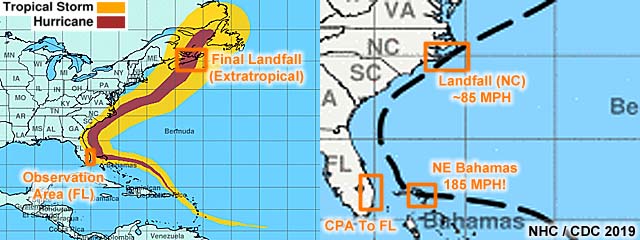
The graphic above shows the path and wind-history swaths of hurricane Dorian (via the National Hurricane Center) during its life-cycle of nearly 2 weeks from around August 25 to September 8. Annotated areas show any significant areas or where observations were done by storm chasing groups. In my case, and unfortunately unable to make the Bahamas target, observations were done in Palm Beach County coastal areas in Florida, mainly on September 1 and 2, during the CPA (closest point of approach to Florida). The Bahamas target area would have been Abaco, which was devastated by the storm at maximum intensity (category 5). After a long and destructive visit to the northern Bahamas, Dorian recurved and made it's first brief USA landfall at Cape Hatteras, NC as a much weaker category 1 storm, and a final landfall in the coastal areas near the Canadian maritime as a powerful subtropical / extra-tropical storm.
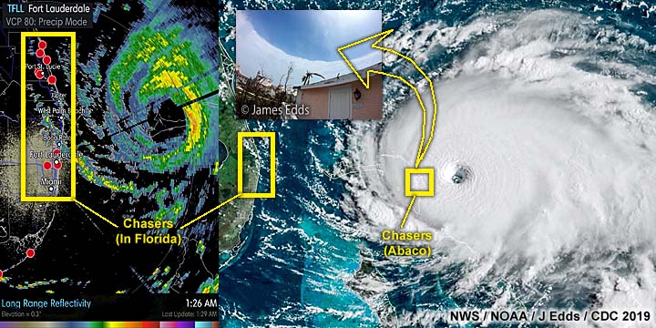
The pictures above show the radar imagery (long range base-reflectivity from FLL terminal Doppler radar) to the left (on September 2 as the storm was devastating Grand Bahama Island), and visible satellite image of Dorian just before hitting the NE Bahamas near Abaco on September 1 at maximum intensity. The annotated area to the left in the radar images shows most storm chasers, including myself, in Florida waiting for the storms closest approach to that area. The storm never directly hit there, stalled, and recurved away from Florida by September 3. The annotations to the right also show the storm chasers in Abaco and their positions, which I also was planning to be, but could not due to canceled flights and closure of MHH just after two other storm chasers, Jim Edds and Josh Morgerman made it there earlier. The inset image is the incredible view of the "stadium effect" inside the eye of Dorian at around noon taken by storm chaser Jim Edds (ExtremeStorms.com) who was in Hope Town, Abaco and just east of Josh Morgerman (iCyclone), who was in Marsh Harbor. For more details on that photo of the eye, please visit the link to Jim Edd's website at www.ExtremeStorms.com. Both these chasers barely escaped serious injury and were in fortified structures during the storm, with Josh reporting a minimum pressure of ~913 MB on handheld instruments.
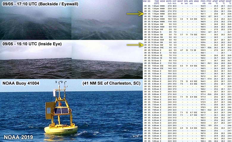
During the morning of September 5, Hurricane Dorian was moving slowly northeast and offshore of the north and south Carolina coasts with winds of 110 to 115 MPH (category 2 / 3). The storm center happened to pass directly over NOAA buoy 41004 (pictured to the lower left), which was about 41 NM to the southeast of Charleston, SC. The right side is the data recorded by the buoy instrumentation. Not only did this buoy capture the passage of the eye, with pressure of just under 960 MB, but light winds of 1 M/S (~2 MPH) inside the relatively calm eye as well. Before and after the eye passage, peak gusts were near 40 M/S (~90 MPH) from the east, then WNW (on the backside of the hurricane), respectively. These winds were lower than those reported by the NHC due to the anemometer being less than 10 M and / or the stronger (right) side of the hurricane missing that location. Even more interesting is that this buoy has a webcam. With mountainous seas with blowing spray and foam (top left pictures) an hour or two after much calmer (with even sunlight peeking through) while inside the eye (middle left pictures)!
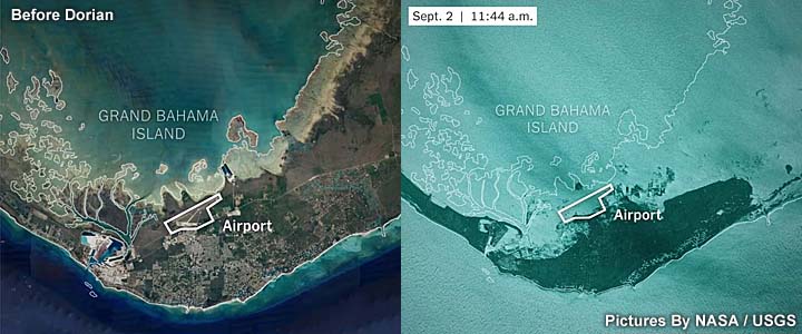
Even more disturbing are these satellite images (USGS) taken of Grand Bahama Island before and just after Hurricane Dorian ravaged it for over 24 hours and recurved out to sea. Dorian stalled over the island as a category 5 storm, with the eye sitting over the middle of the island for at least 24 hours. After the storm departed, and the clouds cleared, a "beaten up" and flooded image of Grand Bahama became apparent. Much of the island was severely eroded, with mangroves and shorelines scoured away, their main international airport (FPO) underwater, and slow-to-recede storm surge literally making the island less than half its original size! The only place that escaped devastation was west end / Settlement Point at the very western tip of the island.
|
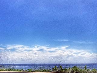
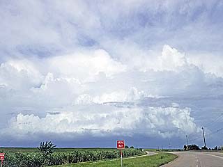
The first view of the cirrus shield of hurricane Dorian looms in the distance looking northeast over a calm ocean near Boynton Beach, Florida around September 1, 2019. The storm was about 250 miles away, and approaching Abaco at the time. There are no waves in the ocean because the hurricane swell waves are being blocked by the "wave shadow" patterns of the Bahamas. |
|
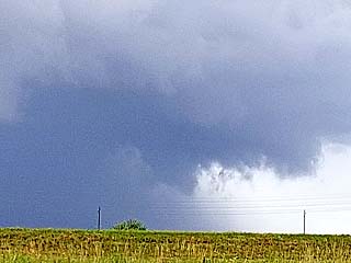
One of the outer feeder bands of hurricane Dorian passes over the Broward and Palm Beach areas on September 2. |
|
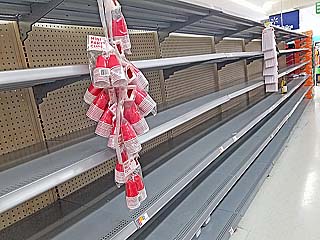
For almost a week before hurricane Dorian was even considered a threat to Florida, the shelves for canned goods, batteries, water, and flashlights quickly became empty at most places. By September 1, the shelves for bottled water looked like this. |
|
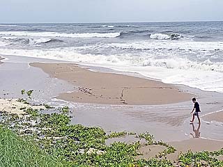
This is a view of the surf in West Palm Beach, Florida as Hurricane Dorian was about 120 miles to the east devastating Grand Bahama Island on September 2. The above normal tides, coinciding with seasonal "king tides", and waves have also caused severe beach erosion. |
|
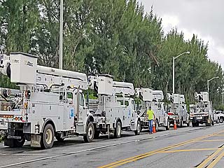
A convoy of utility trucks sets up in case the tropical storm forced winds cause power outages in Palm Beach, Florida on September 2. |
|
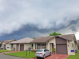
The edge of the gale forced wind envelope (tropical storm forced winds of 38 MPH and up) slowly approach Palm Beach, Florida from the east, marked by dense clouds and feeder bands of showers and thunderstorms late in the day on September 2. |
|
A funnel cloud / possible brief tornado developing on the updraft side of a thunderstorm cell associated with one of the outer feeder bands of Hurricane Dorian during the afternoon of September 2. This is a possible HP storm, called a TCMS (tropical cyclone mini-supercell). |
|
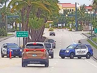
With Hurricane Dorian still offshore of Palm Beach, Florida on September 3, no one without the proper credentials was allowed on any of the barrier island beaches due to flooding. Many police had roadblocks and check points, with anyone caught without authorization subject to being arrested. |
|
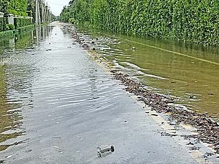
Storm surge flooding at a boat ramp near West Palm Beach, Florida on September 3. |
|
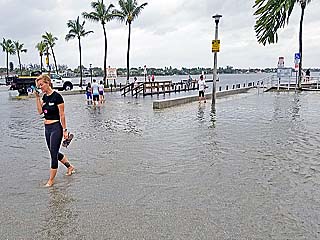
Storm surge flooding at a parking lot / marina entrance in Boynton Beach, Florida on September 3. |
|
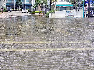
Rising flood waters over A1A due to storm surge on September 3 near Lantana, Florida. |
|
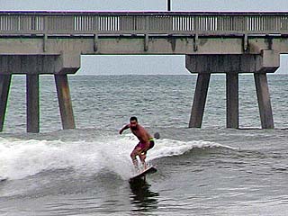
Farther south, waves became smaller due to the swell blocking effects of the Bahamas offshore. Deerfield Beach, here, in Broward County, remained open - But was more crowded than it would be during peak holiday / winter tourism season - With parking issues and unimaginable crowds since the other beaches north were all closed. Here a surfer catches a wave at Deerfield Pier south-side on September 3. |
|
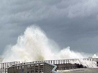
Large waves crashing into the north side of the jetty and pump-house at Boynton Inlet on September 3. Waves increased in height the farther north you went, due to the hurricane moving out of the wave shadow of the Bahamas. Unfortunately surfing up here would have you arrested, as beaches were closed and the area under mandatory evacuations. I had a media pass so I was able to get past police checkpoints and film at my own risk. |
|
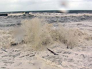
Large wave crashing into the Boynton Inlet north jetty on September 3. Winds here were about 40 MPH gusts from the NNW. Hurricane Dorian was just north of Grand Bahama Island at the time, 130 miles ENE of my location. |
|
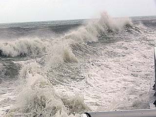
Extremely turbulent surf near the Boynton Inlet pump-house on September 3, with floating debris and silt in the water. |
|
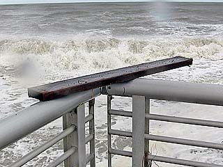
A large piece of lumber, one of many floating in the water, lands on the railing of the Boynton Inlet north jetty by a over-washing wave (as if someone neatly balanced it there)! This is just before police asked me to leave and checked my credentials (September 3). The wood / debris is most likely from a damaged pier, dockage, and / or beach staircase. |
HTML File "dor19.htm" - Developed By Chris Collura
To Return To The HOME Page Of This Site Click The "INDEX.HTM" Link Here!