
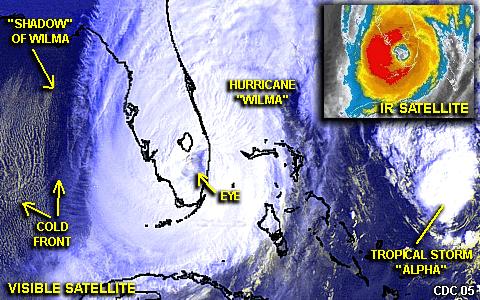
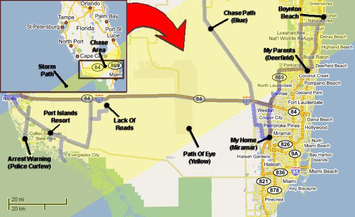
| This area shows pictures taken from the observations and interceptions of hurricane Wilma as it made landfall between Marco Island and Everglades City, Florida, ripped across the state, and re-emerged over the Atlantic off Palm Beach. The storm developed from an area of disturbed weather in the Caribbean Sea and moved to the west and northwest as it became a tropical depression, then a tropical storm with the name "Wilma". Wilma quickly strengthened to a hurricane, then on October 19, intensified explosively to a violent, category five hurricane with 175-MPH sustained winds and the lowest central pressure ever measured in the Atlantic basin at 882 MB, a reading the shattered the previous measure of 888 MB back in 1988 by hurricane Gilbert. The record was not only such extreme intensity measures, but how quickly they were achieved, with explosive deepening records also set where a pressure drop of over 15 MB per hour was observed at one point! Category five hurricanes usually do not remain that way very long, as internal dynamics of the storm cause intensity fluctuations. Wilma went through some peculiar eyewall replacement cycles, transforming the 175 MPH hurricane with only a TWO mile wide eye to a 45 mile wide "annular" type storm with 150-MPH winds as it grinded its way into Mexico's Yucatan penninsula on October 21. The large eye actually stalled for hours over Cozumel, Mexico. The storm meandered over the NE Yucatan for 2 days causing extensive damage and nearly four FEET of rain. The storm re-emerged over the southern Gulf of Mexico as a 100-MPH hurricane early on October 23, suprising for spending so much time over land. It was this point where Wilma finally responded to a low-pressure trough and began its dreaded and ill-fated movement to the northeast toward Florida. Despite nearly all forecasting models showing a weakening storm, Wilma intensified again over the SE Gulf of Mexico, strengthening back to a strong category three storm with 125-MPH sustained winds and a 65-mile wide eye as it made landfall near Everglades City in SW Florida at about 6:30 AM on October 24. Wilma accelerated towards the northeast, and crossed the entire state in a few hours and re-emerged over the Atlantic Ocean off Palm Beach county. The storm only weakened to a 110-MPH sustained category two storm which quickly re-intensified to 125-MPH again over the Gulf Stream current in the Atlantic late on October 24. Wilma continued rapidly northeast, and did not weaken until it got over the cold waters of the north Atlantic. Damage from this large storm was extensive, and over a very wide path (100 miles, or more, wide). The right side (worst winds) of the storm remained south of the populated areas during landfall, but affected Miami-Dade, Broward, and Palm Beach as the center crossed the state. The Florida Keys also were flooded by storm surge. The interception and chase of hurricane Wilma began from near its point of landfall at the Port of the Islands Resort along Tamiami Trail and SE of Naples and Marco Island, then the eye was followed to the northeast into the central everglades near the Cypress preserve east of Highway 29. Initial winds on the NE side of the eyewall were southeast at about 120-MPH at the resort. The eye of Wilma was clear visually, and presented a "stadium effect" with blue sky overhead. Bad road options and limited access to I-595 caused loss of time and a forced penetration of the SW eyewall where 110-MPH winds were observed. The chase then headed back north on 29, then east on I-595 (finally) to the Fort Lauderdale area. Winds were west at over 100-MPH at times, but did not present a driving difficulty because the chase was headed towards the east. Problems began when trying to head north on the Sawgrass Expressway and the FL Turnpike, with flying debris and trees down in 100-MPH (or more) wind gusts. The chase ended near the edge of the eye once more in Boynton Beach in Palm Beach county, where the storm re-emerged over the Atlantic. A large piece of roof debris struck the chase vehicle and broke a mirror on it. The roof-mounted weather station also was damaged, and numerous scratches / dings were noted after the intercept, otherwise the vehicle was OK. The total mileage for this intercept was 910 miles, including ferry time in an out of the target area(s). Note - This page may take a while to load on some SLOWER connections! |
| CHASER NAME | HOME CITY | CALLSIGN | OCCUPATION |
| CHRIS COLLURA | MIRAMAR, FL | KG4PJN | COMPUTER ANALYST |

Both STOCK Footage and DVD video of hurricane Wilma is available in the SPECIAL OFFERS section of this web site. You can visit that area by clicking either the image above or the link HERE!


|
Here is an IR satellite picture of hurricane Wilma as it was about 170 miles Southwest of Naples, Florida. The "donught" shows a nearly "annular" hurricane with an exceptionally large eye developing. Annular hurricanes are notorious for intensity and large swaths of wind damage. This was taken just before midnight on October 23-24 during a data stop at a hotel in SW Florida. |
|
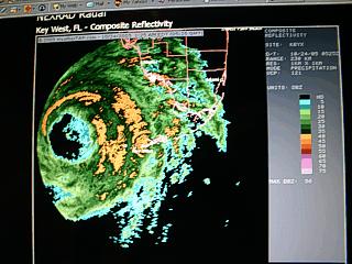
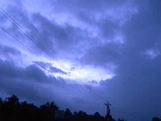
While waiting for the storm to arrive, a data stop near Marco Island, Florida reveals a huge eye and eyewall offshore of southwestern Florida moving northeast from the Key West radar. This was taken about midnight on October 24 when hurricane Wilma had 110-MPH winds. The storm was to rapidly strengthen to 125-MPH at landfall about 7 hours later. Note the small mesovortex (swirl) inside the eye! |
|
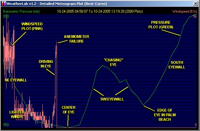
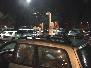
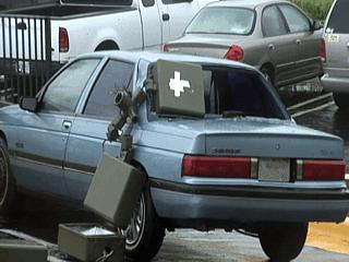
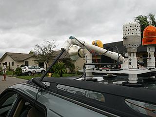
The time spent waiting and watching data on the storm was also a great time to set up the portable weather station on the roof of the chase vehicle. This is the "Weatherlab III", and it is running and porting data to the laptop and console in the vehicle. This is how we are able to get the meteogram plots you see above at the start of this page. |
|
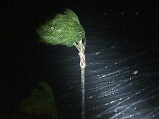
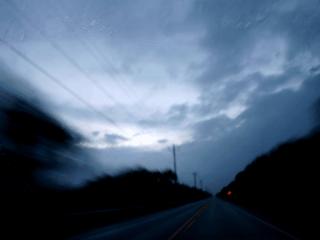
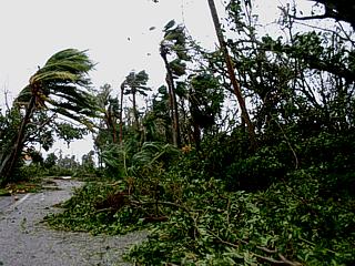
The first part of the storm, including the first half of the main eyewall and landfall came before sunrise (at about 5 AM). In this picture, the first torrential rains and hurricane forced winds hit and a palm tree sways in horizontal rains. The first half of the storm was spent at the Port of the Islands Resort about 5 miles west of highway 29 off Tamiami Trail and about 10 miles northwest of Everglades City. Wilma made landfall just south of this location. |
|
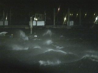
The small inland marina at the resort now has 2 to 3 foot waves in it as with winds approach 75-MPH. A small boat is already sinking to the far left. |
|
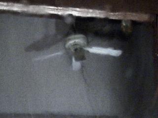
This is a picture of a ceiling fan being destroyed with the onset of hurricane Wilma's stronger winds in front of the marina at the Port of the Islands Resort. |
|
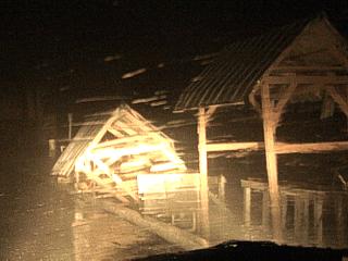
Power is now out and the winds gusting over 80 MPH as the outer portion of the eyewall hits. Visibility is very poor and the roof of one of the fish cleaning stations at the marina comes crashing down. It is now time to head towards the drop-off area canopy in front of the hotel office. |
|
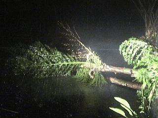
When under the drop-off canopy in front of the resort office, a palm tree comes crashing down as a 100-MPH eyewall wind gust hits. There were several workers at the resort who were all amazed by my setup and also were able to watch the storm from under the canopy. |
|
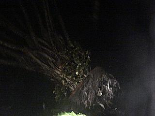
During the height of the winds of the first eyewall, which lasted about an hour, and were from the southeast gusting to near 120-MPH, a large ficus tree tips over in one of the wind gusts. Barometric pressure is falling rapidly, but we should be in the large eye shortly. Time is about 6 or 6:30 AM on October 24, 2005. |
|
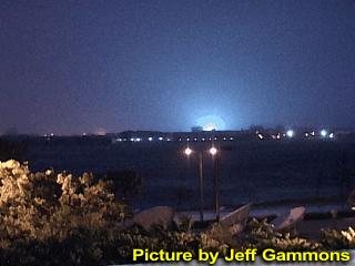
Meanwhile, Jeff Gammons was chasing hurricane Wilma, but nearly 100 miles to my northeast. Jeff captures this power flash in West Palm Beach as the tropical storm forced winds arrive at his location just before sunrise. |
|
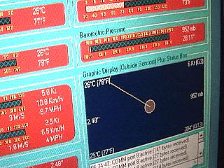
While just about in the eye of the storm, with winds now light and variable, a low pressure of 952 MB is observed with the "Weatherlab III" station. Later, farther into the center of the eye, a pressure of 950 MB was observed, exactly the same as reported by NHC via a NOAA W-P3 aircraft. In this picture, the winds are very light, and the red "guage" just above the symbol graphic to the right shows the 952 MB (or 28.11" of mercury) pressure on the display for my custom software I wrote for the data logging. |
|
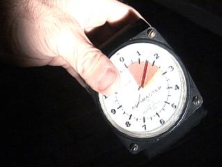
Here is a picture of my skydiving altimeter while entering the eye of hurricane Wilma. It is reading approximately 1,700 feet. Ofcourse, we are not in the air or atop a mountain, but simply in the low-pressure center of hurricane Wilma so that the air is "thinner" and therfore registers at "height above sea level" since the altimeter works by air pressure (aneroid). We are at sea level, and 1,700 feet of air in the storm core is "missing", but the altimeter doesn't "know" that. |
|
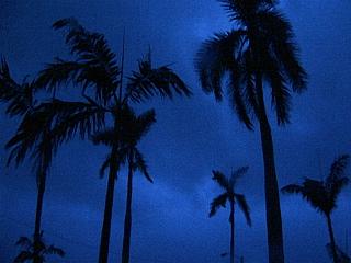
The sun is now coming up at around 7:00 AM and the sky is brighter inside the eye of hurricane Wilma. The palm trees lucky enough to survive the brute first eyewall winds are nearly still, as breaks in the clouds begin developing. After this, I decided to remain inside the eye as long as I could and "chase" it as it moved northeast (until road network issues arose)! |
|
This is a picture of the "pressure center" of hurricane Wilma's large eye while near highway 29 along Tamiami Trail while looking northeast at about 7:25 AM in Collier County, Florida. The low clouds in the center of the large eye break because of sinking air, and a view of sunlight, blue sky, and even the eastern eyewall (called the "stadium effect") peeks through the break in the clouds. A downed powerline did hit my vehicle about this time, damaging an antenna and the anemometor, but not the rest of the weather station. Also, the lowest pressure of 950 MB was measured with my equipment here. |
|
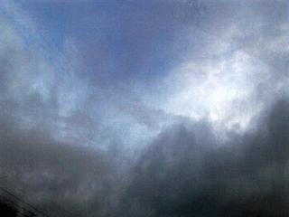
This is a picture of the calm and clearing in the large eye of hurricane Wilma just after making landfall near Everglades City. The view is to the east and northeast along Tamiami Trail just west of highway 29 in Collier County, Florida at about 7:30 AM. The storm still has 120-125 MPH sustained winds, but here winds are calm and blue sky shines overhead just after sunrise. Note the dark "wall" of clouds extending in a curve from left to right above the horizon - That is the eastern eyewall. This type of "curved" view of the eyewall in a storm like this is all around you with blue sky overhead, as long as the low clouds beak in the eye, as they did here, presenting a dramatic "stadium effect". |
|
Looking straight up towards the sky while inside and nearer to the edge of the eye of hurricane Wilma revealed thin clouds and blue sky as in this picture ... Note the blue sky and brighter edge / top of the eyewall "rim" illuminated by the rising sun! |
|
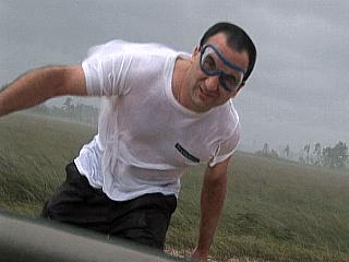
While attempting to follow the eye, a northeast track was not possible because of having to cross the Florida Everglades. Near highway 29, the second half of the storm eyewall nears and winds quickly pick up to 80 or 90 MPH (with the 110-120 MPH winds a bit farther out). Here I am standing in the strong winds to show the effects before blasting north on highway 29 to meet I-595 to continue east. I am free of any up-wind debris (open area) for safety (don't try this yourself). The skydiving goggles are a MUST! |
|
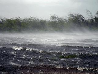
Winds gusting well over 100-MPH south of the eye of hurricane Wilma kick up dramatic spray off a canal on the south side of I-595 in the Florida Everglades. These destructive winds, enhanced severely on the right-side of such a hurricane moving NE at 20-MPH, will soon move out of the unpopulated Everglades and reach the populated areas on the south Florida coast. One portion of the Everglades had so much spray kicked up by the wind that you could not even see the water anymore! |
|
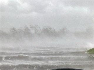
When a 115-MPH gust goes by, we get what hurricane chasers call a "whiteout" where there is so much spray, rain, mist, etc in the air that you cannot see very well and the visibility is near zero. This is the same location as the picture above, just with a stronger wind gust. The 100-MPH plus tail winds (from the west) made driving east difficult, but since I was literally being "pushed" by these winds, I used NO GAS during the 60 mile drive from highway 29 to the Sawgrass Expressway in Broward county, that is, until it was time to turn north! |
|
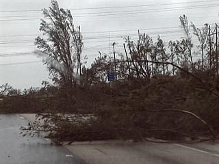
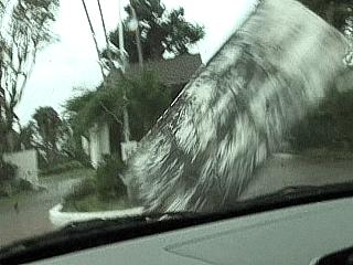
If it was not the wind, it was the trees that became a problem. Once into Broward and Palm Beach counties, it was time to head north since the edge of the eye was reached on the Sawgrass Expressway and FL Turnpike. Here, trees lay across the road and block my way. Debris was in the air, and at one point the side-pushing winds from the west were so strong it broke a windshield wiper off my car! I really though I would flip over at one point. |
|
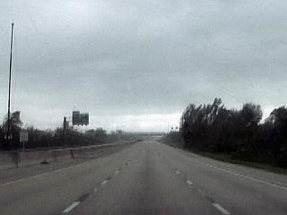
In Palm Beach county, the southern edge of the eye (bright area ahead) is once again visible while looking north on the FL Turnpike near Boynton Beach. Winds here are still west at about 80 MPH, but slightly less than a few miles prior in the eyewall. Pressure here falls again and is measured at 958 MB (the center was 952 MB at the time, but went offshore of Palm Beach and could not be intercepted again). |
|
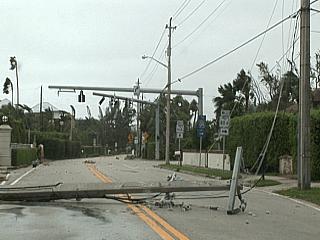
Downed trees and powerlines cover the Ocean Boulevard (or highway A1A) in Boynton Beach, Florida. The storm is still moving northeast as the eye just moved off Palm Beach, and winds are picking up from the west now as the second eyewall encroaches upon the area. Note the small airborne debris in the top of the picture. Winds are 80-MPH and gusting over 100-MPH, blowing things in the opposite direction as they did before the eye (note many trees laying from right to left, but the winds now blowing left to right). The view is to the north. |
|
Here is another picture showing a collapsed power pile and powerlines across A1A in Boynton Beach just before the second eyewall hits. Winds here are west at about 80-MPH, gusting to 100-MPH. |
|
And then it happens. A flying piece of plywood is seen spinning and rushing in the air towards me and my vehicle! Time to brace for impact! |
|
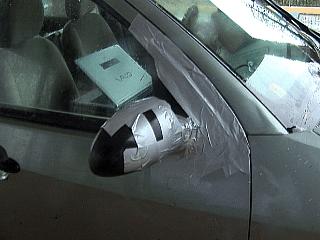
About a half a second later, the board strikes the front of my vehicle in winds gusting near 100-MPH. It slams my hood, causing dings and scratches, then rolls to the right and takes out my passenger side mirror. This is about $500 worth of damage, but I still consider myself lucky. Time to get into a safe place for the second half of the storm fast! |
|
Not wanting to press my luck, I decided to wait out the eyewall passage at the Holiday Inn Express off Boynton Beach Boulevard under the frontage canopy. This also allowed me to put duct tape on my passenger side mirror, which was broken off by a board that hit my vehicle and dangling. Thank God for duct tape! |
|
This vehicle was not so lucky, a light pole crashes down on it and takes out the back window in the parking lot of the Holiday Inn Express. The light pole then rolled off the car leaving the rear window missing. |
|
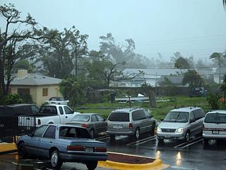
This is at the Holiday Inn Express off Boynton Beach Boulevard. The view here is to the southeast, and winds are west (from right to left). At this time hurricane Wilma still had 110-MPH winds, and was moving back out over the ocean (where it once again re-strengthened to 125-MPH). Note the downed trees and destroyed fence. Also, the same blue car is in the left-foreground is missing its rear window as a light post came crashing down on it. |
|
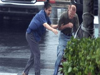
An older couple attempts to go outside and check their damaged vehicle, as hurricane Wilma makes them think otherwise really quickly. |
|
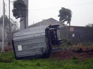
This is a picture of a small construction trailer that crashed though a fence and came to rest against a pole alongside the entrance ramp to I-95 off Boynton Beach Boulevard. This was a commin sight at construction areas. |
|
Hurricane Wilma was a very fast moving storm as it exited Florida near Palm Beach and re-emerged over the Atlantic. Once out of the eyewall and south of the hurricane core, some impressive low cloud banding, called cloud "streets", can be seen. Cool, dry air quickly advected in behind hurricane Wilma as a cold front also passed in right behind the storm. |
|
This picture shows the "Weatherlab III" weather station damaged from a powerline that sheared off the cellular antenna and anemometer mast. This can easily be repaired since it is PVC tubing. The anemometer and antenna is more difficult to replace. Damage like this is EXPECTED when hurricane chasing! |
|
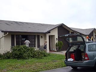
After wrapping up the chase with hurricane Wilma, this storm was not a "chase and go home storm" ... "Home" was unfortunately in its path for myself and my parents. In this picture, my father is covering a shattered window as a tree fell on it during the storm. Also note the roof shingles scattered on the lawn. My parents actually were lucky, and had less damage then others in their community. I stopped over their place in Deerfield Beach to help them out. |
|
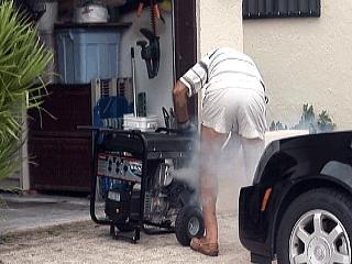
My father starts up the generator in his garage after hurricane Wilma. This began a long wait for power restoration, as much as a month in some areas! At night, there was so little "light pollution" that the full Milky Way and stars could even be seen over the Fort Lauderdale, Miami, and Palm Beach metro areas - A normally impossible sight due to so much lights! |
|
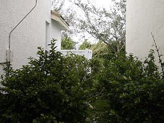
About 30 miles to the southwest in Miramar, Florida, the same scene of damage was evident. Damage to my home was some roof shingles blown off, damage to my back-yard fencing, and some trees down. Luckily, I did not lose any windows or have any severe damage. Nearly all of the trees in my community were destroyed, and will take time getting used to. In this picture, tree debris lies between my home and my neighbor's. |
|
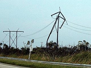
This is a mangled transmission line stansion on the right side of highway 27 in northern Broward County, Florida after the storm. The stansion to the far left is the way it should be. This is why power can be out for so long after a hurricane. |
|
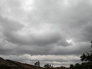
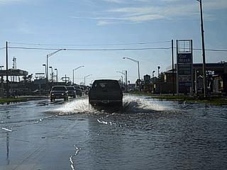
Nearly 70 miles to the northwest, and across the opposite side of the passage of the eye, Clewiston still had some damage and flooding from Lake Okeechobee. Streets here are still flooded a few hours after hurricane Wilma moved out of the area. Also note that after such a violent storm, now there is almost no clouds in the sky! A cold front pushed in immediately behind hurricane Wilma and brought clear and cool weather in just hours later. |
HTML File "wil05.htm" - Developed By Chris Collura
To Return To The HOME Page Of This Site Click The "INDEX.HTM" Link Here!