
| This is my picture based log by chronological order of some select pictures of storm chases and observations conducted during the period from year 1990 to 1999. This log is separate from any storm chase expeditions to the US plains or Midwest, and does NOT include tropical cyclone interceptions. These other chase logs are available as separate logs from the main storm chasing section. This log is for most "home" chases in the state of Florida or for other miscellaneous storm or coastal observations. Keep in mind that this log is scientific evidence and portrays my on-going storm chasing research. It has been placed on this page for easy reference and meteorological interests. Please do not plagiorize or copy this document to other sites for distribution. Feel free to browse through my main storm chasing picture section. Note - This page may take a while to load on some SLOWER connections! |
TABLE OF CONTENTS - CLICK TO GO TO PAGE
|
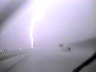
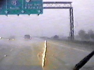
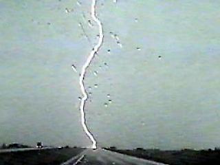
During a severe thunderstorm penetration along Interstate 595 in Broward County, Florida on July 22, 1990, a bright CG lightning strikes the center median. |
|
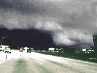
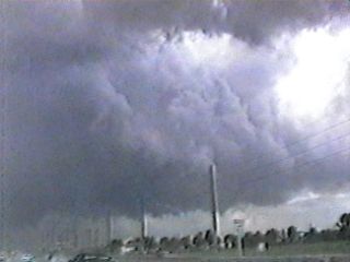
A shelf cloud associated with the outflow side of a severe thunderstorm in Coral Springs, Florida on August 9, 1990. The storm here had half to three-quarter inch hail and 65 MPH winds. |
|
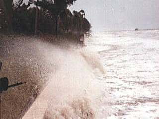
During a severe winter storm in March of 1993, 60 MPH winds from the northwest slam ashore in Fort Meyers, Florida. The storm surge in the Gulf Of Mexico was up to 12 feet causing widespread coastal flooding and damage. This picture was taken during the afternoon of March 13, 1993. |
|
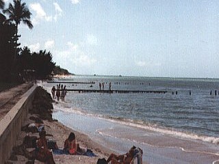
This picture was taken taken at the same location as the previous one on an earlier date during calm weather. This calm picture, being at the same location with a similar camera angle, can be used to compare the two extremes. Try comparing the height of the storm surge to the structures as well as the people standing on the beach! |
|
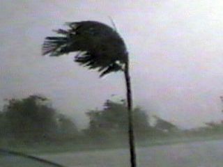
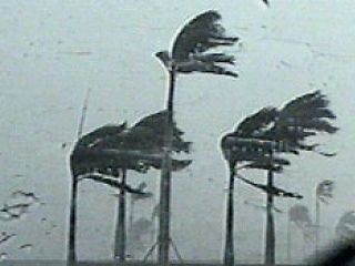
Straight-line winds, over 70 MPH, slam a stand of trees along Hillsboro Blvd in Deerfield Beach, Florida on May 19, 1994. The storm was caused by a line of severe thunderstorms. |
|
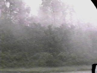
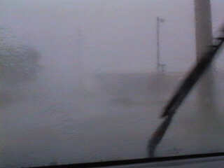
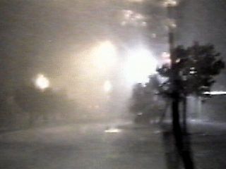
Low visibility and blinding rain in the precipitation core of a severe thunderstorm in Hollywood, Florida on August 7, 1994. This storm had 65 MPH winds, large hail, and frequent lightning. Streets were flooded and power was knocked out. |
|
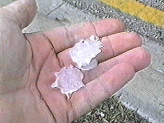
Hail up to golfball size pelts Fort Lauderdale, Florida during a severe supercell thunderstorm On March 18, 1995. At one point, the hail covered the ground with accumulations up to an inch. |
|
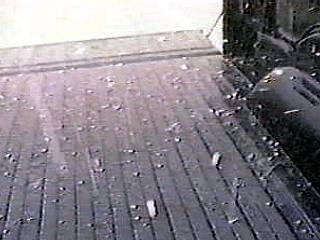
During a hail storm on March 18, 1995 in Fort Lauderdale Florida, marble sized hail bounces in the bed of the Dodge Dakota Pickup being used as the chase vehicle. |
|
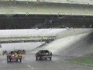
To avoid large hail and zero-visibility, some motorists avoid the weather by hunkering down beneath a highway overpass. These cars are avoiding a hail storm on March 18, 1995 in Fort Lauderdale, Florida. |
|
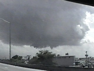
This is a rear view of the supercell thunderstorm that produced hail which covered the ground up to the size of golfballs in Fort Lauderdale, Florida on March 18, 1995. This view shows the main inflow flanking line just above the ground from right to left as well as a second inflow band in the extreme top of the picture. The grey precipitation to the left is the hail shaft. One of the lowerings just right of the storm core in the bottom-center of the picture evolved into a large waterspout just offshore of Broward County, Florida. |
|
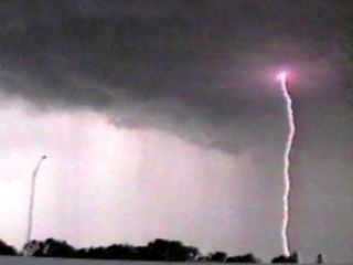
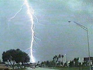
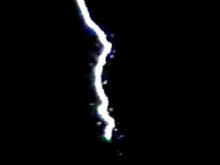
A CG lightning bolt near Interstate 95 in Fort Lauderdale, Florida on July 9, 1995. The bolt here is just south of the storm's rain core on the southwest side of the developing severe thunderstorm's rain free base. |
|
A severe thunderstorm just west of the Loxahatchee wildlife refuge in western Broward County, Florida on July 21, 1995 produces a gust front which overtakes and reinforces a weaker previous gust front. This is common with multi-cell clusters of storms like this one. The reinforced gust front produced winds over 65 MPH after this picture was taken. |
|
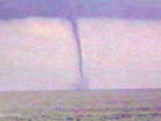
A large waterspout develops on the southwest side of a thunderstorm southeast of West Palm Beach, Florida on September 9, 1995. This picture is a closeup of the well developed waterspout. |
|
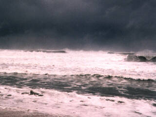
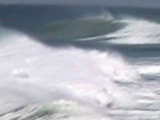
A beach near Reef Road in Palm Beach, Florida on March 12, 1996 1996 during a major winter storm off the Florida East Coast. Waves here are northeast swells up to 20 feet high breaking almost a mile offshore. |
|
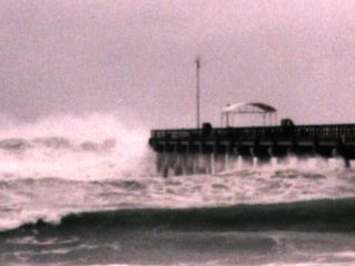
During a major Nor'Easter off north-central Florida, waves batter the end of the Lake Worth Municiple Pier on March 12, 1996. The end of the pier was damaged by the waves, which were northeast swells over 15 feet high. |
|
Caught using a camcorder, lightning strikes a telephone pole during a severe thunderstorm in Fort Lauderdale, Florida on June 23, 1996. This caused an electrical fire and a blackout. |
|
This is a rather dramatic picture of a leader feed literally coming off the front of my Dodge Dakota Pickup as I am penetrating a severe thunderstorm on June 23, 1996 in Western Fort Lauderdale, Florida. Remember, a metal car is the safest place from lightning due to the "Faraday Cage" effect where the electric current flows around you through the metal of the car rather than through you. This frame is one of two video frames, the second being the main lightning CG bolt hitting a pole up the road. |
|
A CG bolt of lightning strikes a telephone pole and causes a power flash on the powerlines. This is a second video frame taken from this strike, the first showing a leader feed coming off the front of my truck! |
|
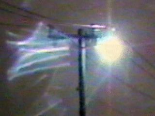
A spectacular and elusive phenomina with a very logical explanation, ball lightning. This is a telephone pole after being struck with a CG bolt of lightning during a severe thunderstorm on June 23, 1996 in Western Broward County, Florida, near Griffith Road. The surge of voltage initiated an arc between two of the high-voltage lines on top of the pole. The arcing continued up to 10 minutes after the strike which created this fireball of plasma that appeared to dance atop the wires. I would consider this just an electrical phenomina that is considered a TYPE of ball lightning. |
|
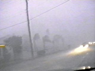
During a severe thunderstorm in Hollywood, Florida on September 21, 1996, 70 MPH winds with rain and large hail cause zero visibility when driving through the storm core. |
|
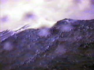
Observing a Nor Easter with waves up to 20 feet near Boynton Beach, Florida on November 15, 1996. The storm had northeast winds gusting near 60 MPH. This is a view of the surf zone from a 1993 Sea Doo Xp watercraft. |
|
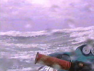
During a coastal observation off Boynton Beach, Florida on November 15, 1996 using a Seadoo XP watercraft, winds exceeding 45 MPH and seas near 20 feet are encountered a few miles offshore. This picture shows the back of one of the huge wind driven waves in the Gulf Stream. |
|
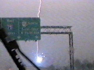
Captured from a single video frame, a CG lightning bolt strikes a sign on the west side of Highway 27 in Western Palm Beach County, Florida on April 23, 1997. This is the first of two frames of video of this lightning hit. The yellow color is due to the relatively low temperature of the initial lightning forward stroke phase. |
|
This is another frame of a CG lightning bolt striking a sign on the west side of Highway 27 in Western Palm Beach County, Florida on April 23, 1997. This is the second of two frames of video of this lightning hit. The return stroke phase of this bolt appears brilliant blue as the maximum temperature of the air is achieved along the lightning channel. This left my left eye with an after image for nearly four hours after chasing this storm. My right eye was looking through the camcorder eyepiece. |
|
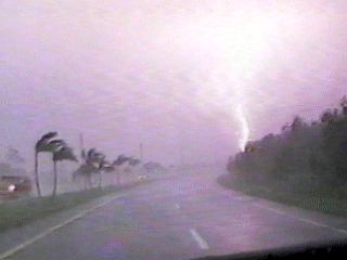
During the penetration of an HP supercell thunderstorm on April 26, 1997 in western sections of Miami, a palm tree is blown by winds near or exceeding 70 MPH. |
|
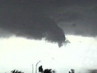
This is the core of an HP supercell that developed in the Florida Everglades on April 26, 1997 and moved into western sections of Miami near Krome Avenue and Tamiami Trail. Large hail and 70 MPH winds were found in this storm with a powerful mesocyclone. Note the CG lightning and bending palm trees in the near hurricane conditions of the supercell core. |
|
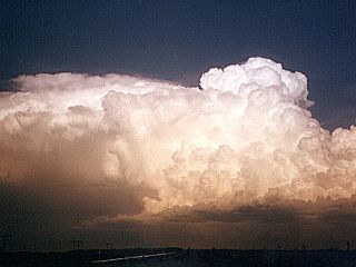
A photogenic view of the western side of a supercell thunderstorm over Fort Lauderdale, Florida on May 31, 1997. This storm was producing golfball sized hail as this picture was being taken, from about 20 miles west of the storm. Note the single updraft as well as the "upside down" convection to its left above the small rear inflow tail. The main flanking inflow is to the right of the updraft. |
|
A tree limb lies in the road after the passage of a tornadic supercell thunderstorm on February 2, 1998 in Miami, Florida. The storm was an HP supercell with winds gusting over 100 MPH in various areas not including a strong F2 tornado that the storm spawned. This was a very common sight after the passage of this storm. Note the power is out and only headlights illuminate the damage. |
|
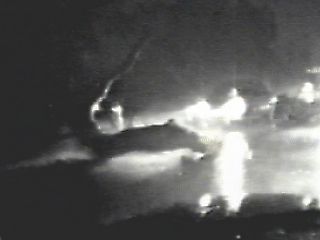
Penetration at night of an HP supercell in Miami-Dade county on February 2, 1998. The tornadic supercell is just west of my position and 70 MPH, or more, winds are blowing from the south. This was the east side of the strong mesocyclone, which eventually evolved into a multiple-vortex F2 tornado in north-central Miami. A piece of a billboard sign can be seen laying in the road, just before the storm cut the power. |
|
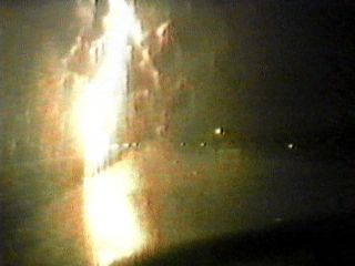
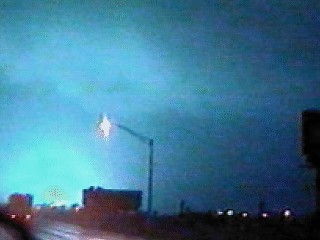
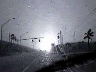
During the tornado interception of March 9, 1998 along Interstate 95 near Hollywood, Florida, a powerline gets taken out by the tornado and illuminates the sky. The power flash provided all the light for this photo. The tornado ripped across Interstate 95 and overturned the truck in the foreground just minutes later. The view is to the south near a tornadic HP supercell thunderstorm at about 6:00 AM. Note the cloud base of the "bears cage" illuminated by the powerflash. Can you see the "swirl" in the cloud associated with the tornado? |
|
A tornado crosses Interstate 95 in Hollywood, Florida on March 9 1998. The tornado passes right over my pickup truck and flips a tractor trailer over. This picture is what I saw as the pressure drop was popping my ears and my life was flashing before my eyes. The tornado even lifted the front of my pickup a foot or two off the ground. The camera rolled throughout the entire event. The tornado was a strong F1 to borderline F2 on a scale from F0 to F5. Note the blur across the lower right side of the photo, that is a roof tile from three blocks away that missed my windshield at 100 MPH. |
|
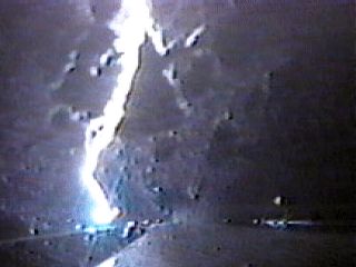
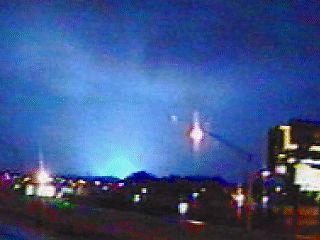
A power flash lights up the sky during the interception of a tornadic HP supercell storm in Hollywood, Florida on March 9, 1998. This picture is another of two such power flash shots. Can you see any suspicious lowering in the cloud base? Only the power flash provided the illumination of the cloud base for this picture. The power flash was caused by a tornado on the ground taking out powerlines, and overturned a semi trailer just minutes later. |
|
A rather rare type of Florida thunderstorm, an LP supercell thunderstorm develops in northern Miami, Florida on May 6, 1998. Note the entirely rain free and round base and updraft with the wall cloud and funnel. This storm also produced nickel sized hail, barely visible, in the hail shaft on the left side of this picture. The storm quickly evolved to HP mode afterwards. of this picture, |
|
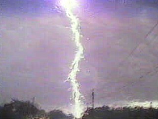
A CG lightning bolt strikes the ground near the Sawgrass Expressway in northern Broward County, Florida on July 8, 1998 during a strong to severe thunderstorm. Note the branchlike appearance of the lightning bolt, commonly referred to as forked or chain lightning. This type is the most dangerous to people caught outdoors in a storm. |
|
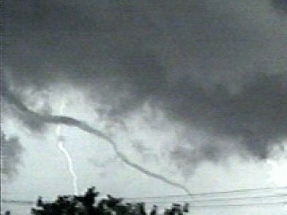
A rope type tornado on the south side of a high precipitation supercell along Highway 27 in the Florida Everglades on August 5, 1998. The name "rope" comes from the thin appearence of the long vortex tube. Note the lightning behind the tornado. Large hail and 70 MPH winds were also encountered with the thunderstorm. Rope type tornadoes are usually during the late stage of a tornado, but are still dangerous. The view here is to the northeast. |
|
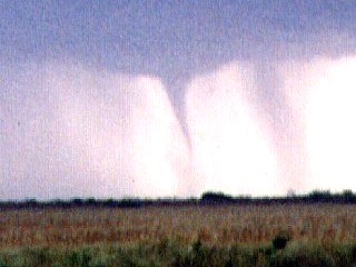
An F1 tornado developes on the western side of an HP supercell about 10 miles southwest of Holiday Recreation area near Highway 27 in the Florida Everglades. The tornado was on the ground and moved slowly for about 5 to 10 minutes. This picture is a zoom into the tornado looking towards the southwest. Note the rain wrapping around the foreground of the tornado from left to right. This picture was taken on August 5, 1998. The parent thunderstorm had hail and 65 MPH winds. |
|
During a chase day in western Broward County, Florida and the Everglades on August 5, 1998, a severe thunderstorm produces 70 MPH straight line winds as it "gusts out". This storm was part of a system of thunderstorms which also produced flooding, hail, and tornadoes. |
|
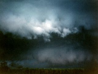
A wall cloud on the rain-free base of a developing severe thunderstorm in western Broward County, Florida on August 5, 1998. This wall cloud was not rotating, but did eventually manage to produce a small funnel on its tip as pictured here. The storm precipitation core is right of this picture. |
|
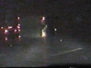
Damaging winds and lightning knock out power during a storm near Weston, Florida on August 5, 1998. The pole transformer exploding here lights up the whole sky. Note that the traffic lights and street lights are not working. |
|
A CG lightning bolt in the Florida Everglades hits Interstate 595 on May 8, 1999. Note the greenish hue to the precipitation behind the lightning bolt, caused by copious amounts of pea to dime sized hail. |
|
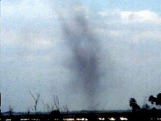
A dust devil off Highway 27 in the farming areas of Palm Beach County, Florida. These are dry vortices of warm rising air that form in moderate winds blowing over warm ground. The dust devil here lasted only about one minute. This picture was taken in April 1999. Note the hollow structure of the vortex. |
|
Large northeast swells breaking down the beach in September 1999 in Palm beach, Florida. This is looking to the south down the beach. The swells were generated by hurricane Dennis off North Carolina. |
|
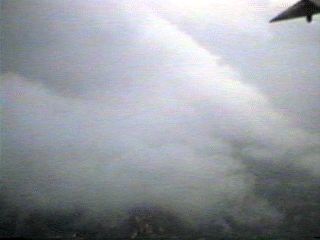
This picture shows the top of a strong gust front during a stormy flight out of Greensboro, North Carolina in May 1996. The wing tip is visible in the upper right side of the picture during this steep and bumpy climb. The top of the shelf cloud is clearly visible and even sports a curved surface contouring the surface of the cooler, and heavier outflow air from the thunderstorm along the gust front. |
|
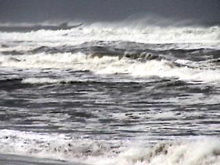
A hurricane surf along Boynton Beach, Florida in September 1999 as Hurricane Floyd, with 155 MPH winds, passed a mere 100 miles to the east. The swell and wind waves here form a confused sea under a grey sky. Tides were also about 3 feet above normal. Since this was an evacuation area, I was politely asked to leave after taking this picture. |
|
Captured from a single video frame, lightning hits the top of the radio tower for WCTH during a strong thunderstorm in Plantation Key in the Florida Keys. The picture was captured from a video of the thunderstorm at night viewed from a houseboat anchored in a nearby cove. The storm occured in July of 1995. The bottom of the bolt in this picture is where the top of the radio tower is. |
HTML File "stplog2.htm" - Developed By Chris Collura
To Return To The HOME Page Of This Site Click The "INDEX.HTM" Link Here!