
| This section is dedicated to natures most spectacular display of "fireworks" - Lightning! What lightning really is is a massive electrical discharge between to fields of static electricity developing as charges in a cloud separate from air currents and / or falling water droplets or ice particles. Lightning can be between two cloud areas, as CC (cloud to cloud) lightning, or from the cloud to the earth, as CG (cloud to ground) lightning. Lightning heats and ionizes the air along the discharge path, forming a hot plasma up to 60,000 degrees! Thunder is the rapid expansion of hot gases along this channel causing a shock wave. There are several pictures of this impressive and dangerous electrical phenomina for viewing in this area, so enjoy! Note - This page may take a while to load on some SLOWER connections! |
|
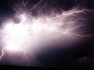
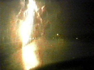
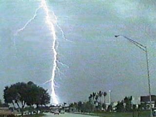
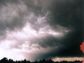
This is a still photograph of a brilliant display of a mixture of cloud to cloud (CC) and some cloud to ground (CG) lightning over west Texas in May 2000. This is a 5 to 10 second time exposure of an elevated thunderstorm cluster using asa200 with an f-stop of 5.6. |
|
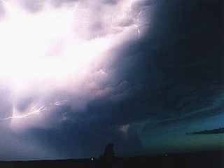
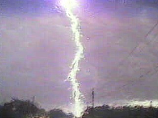
Same storm as the picture above in Western Texas in May 2000. This is a 10 second time exposure using asa200 with an f-stop of 5.6. Intense cloud to cloud (CC) lightning illuminates the underside of elevated severe thunderstorms, even the storm structure and dry line can be seen in this time exposure from the waning sunset. |
|
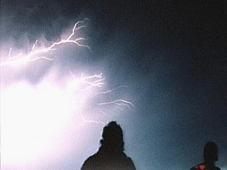
The silhouettes of myself and Jeff Gammons watch the display of CC lightning in Western Texas in May 2000. This is a 15 second time exposure using asa200 with an f-stop of 5.6. |
|
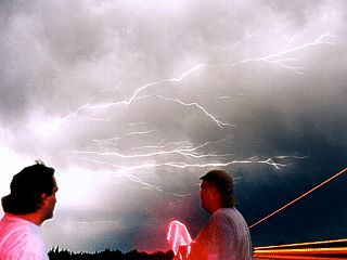
Another similar type shot as a 15 second time exposure using asa200 with an f-stop of 5.6. Myself and Dave Cornwell watch CC lightning after a severe thunderstorm and supercell encounter in southern Texas in May 2001. The streaks of red and yellow are from a passing semi-truck. |
|
This is a first video frame-grab of a direct cloud to ground (CG) lightning hit less that 100 feet away while chasing a severe thgunderstorm in April 1997 near Palm Beach, Florida. The lightning bolt here appears yellow due to its temperature at the time the video frame was grabbed (each video frame is about 1/30 of a second). |
|
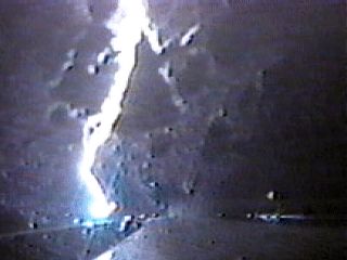
This is a second video frame-grab of a direct cloud to ground (CG) lightning hit less that 100 feet away while chasing a severe thgunderstorm in April 1997 near Palm Beach, Florida. The lightning bolt here appears a brilliant whitish-blue due to its temperature at the time the video frame was grabbed (each video frame is about 1/30 of a second). This bolt actually left an after image in my left eye (the video camera eyepiece protected my right eye) that lasted for a few hours. |
|
This is a first video frame-grab of a step leader just prior to a CG lightning hit farther away while chasing a severe thgunderstorm in Broward County, Florida in June 1996. The step leader is the yellow "flame streak" in the foreground, and yes ... You see it right, it is coming off the front of my Dodge Dakota Pickup chase vehicle! |
|
This is a second video frame-grab of a cloud to ground direct hit to a power pole about 300 yards away less than a second after the above frame. This is the same June 1996 storm. The step leader was just a "warning" because I was driving through the intense static field. Moments later, the direct hit to the pole causes a massive power surge and fireball atop the power lines. After that, power goes out as the transformer blows. |
|
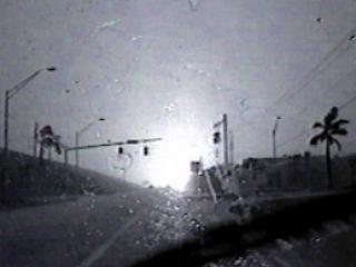
This is another video frame grab of the June 1996 storm above in Broward County, Florida. The cloud to earth lightning strike, distorted by rain on the windshield, hits a power pole and takes out the power. |
|
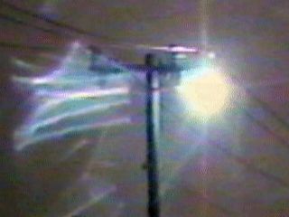
This video frame grab shows a continuous plasma "ball" arcing over the power lines during the June 1996 storm. This was caused by the same bolt as in the picture above, and may actually be thought of as "ball lightning" when in reality it is a power arc sustained atop the high voltage wires. This event lasted for about 3 minutes. |
|
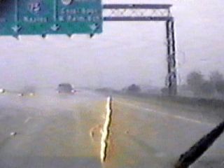
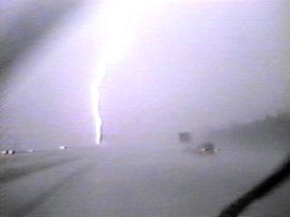
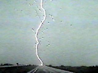
Video frame grab of a bright and intense cloud to ground lightning strike on Interstate 595 in Broward County, Florida in July 1990. |
|
Another video frame grab of a cloud to earth lightning strike near Interstate 95 in Fort Lauderdale, Florida in July 1995. |
|
This is a video frame of a forked variety of cloud to earth lightning, near Coral Springs, Florida in July 1998. |
|
In this video frame, taken in August 1998 along Interstate 595 in Weston, Florida, no lightning bolt is visible but a "pole pig" type distribution transformer shorts out and explodes into a fireball from a power surge during a severe thunderstorm. The lightning apparently hit the high voltage wires out of the video frame but the transformer blew as a result of the power grid overload. Note that the gas station to the right has no power. |
|
This video frame shows another CG lightning strike near Interstate 595 over the Florida Everglades in May 1999. This strike started a fire that burned for nearly a week. The greenish color of the sky is from hail. |
|
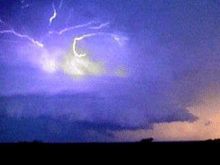
This is a video frame grab of some impressive cloud to cloud lightning around an HP supercell thunderstorm in May 2001 near Junction, Texas. |
|
More cloud to cloud (CC) lightning crawls through the mammatus fields of a supercell thunderstorm in southern Texas in May 2001. This time exposure reveals the "dendrite" or "anvil crawler" type lightning after dark as I watch in awe to the right (red face from flashing lights of chase vehicle). Time exposure is 10 seconds at f5.6 with asa200 film. |
|
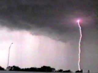
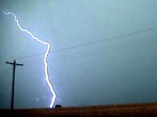
A video frame grab of a cloud to ground (CG) lightning bolt from an elevated severe thunderstorm in SW Kansas in May 2002. |
|
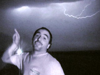
A video frame grab of myself pointing to a monster HP supercell thunderstorm (out of frame to the left) as a flash of cloud to cloud (CC) lightning occurs overhead in Texas in May of 2002. |
|
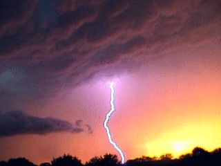
A breath-taking video frame grab of cloud to ground lightning through the vault region of an HP supercell thunderstorm in May 2001 near Rock Springs, Texas. This storm had almost every color in the rainbow. |
|
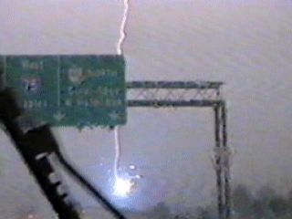
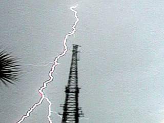
Here is a cloud to ground (CG) bolt of lightning (video frame grab) near a radio tower on March 16, 2003 in Wellington Village Park near West Palm Beach, Florida. Note the forking near the base of the lightning bolt. |
Cloud to cloud lightning has the acronym "CC". It occurs between two or more cloud regions above the ground. Sometimes the bolt will "break-out" from a cloud into the surrounding air.
Cloud to ground lightning has the acronym "CG". It occurs between the clouds above and strikes the ground. This is obviously the most dangerous type of lightning. It can also occur over water (cloud to water lightning).
Lightning is formed by CHARGE SEPARATION among particles or droplets in a cloud (usually water or ice). The cloud separating the charges need not be water-comprised ... Volcanic ash / steam clouds have also produced vivid lightning! As long as droplets (or particles such as ice) separate charges as they interact with air currents, a static field should be generated (like walking across a carpet and touching a door-knob). When these charges exceed the resistance of the air between them, a discharge of electricity occurs.
Lightning can have a positive or negative charge, depending on where in the cloud it originated from (or is going to). The top of a thunderstorm usually carries a positive charge, while the base carries a negative charge. This is called CAPACITANCE. The like charges repel each other, therefore the ground right under a thunderstorm becomes positively charged while a ring a distance around and away from the storm becomes negatively charged. Charges between the higher positive and negative fields cause cloud to cloud (CC) lightning inside the thundercloud. Negative charges in the cloud base and the positive charges on the ground under the storm account for cloud to ground (CG) lightning. Sometimes, a "superbolt" discharge can occur between the ring of negative charges around the storm and the positively charged storm top!
The flow of electricity during an electrical discharge is always from a negative potential to a positive potential. A typical CG lightning strike between the ground and negatively-charged thunderstorm base often goes from the cloud base, to the ground, then back up again. This is called a FORWARD STROKE, and RETURN STROKE, and may actually repeat several times until the charge fields are below the threshold for a discharge. That is why lightning usually "flickers" where it seems to flash several times with the same bolt.
Thunder is simply an intense sound wave and / or shock wave created by an explosion that occurs along the extremely hot lightning channel. When the voltage difference between the two charged fields, called a POTENTIAL, becomes too great, a BREAKDOWN in the air separating them occurs (this is where the air becomes IONIZED and can conduct electricity). The breakdown literally discharges a potential of up to hundreds of millions of volts at many tens of thousands of amperes along this ionized path. The ion path becomes up to 5 to 6 times the temperature of the sun's surface in fractionths of a second. This ionized gas is called PLASMA. Hot gases expand, and does so at supersonic speeds creating a shock wave along a lightning channel.
The resulting "boom" of thunder is the result of the shock / sound waves created by lightning close to the ground. The "rolling thunder" effect is caused by the sound produced along a long, irregular path where the sound from many portions along the path arrive at different times to the oberver. Clouds, land terrain, and air density (lightning can occur higher up where the air is thinner) also affect the sound of thunder.
Other names for lightning can be chain, zig-zag, or forked lightning. The shapes and branches of the lightning channel determine such names. "Sheet lightning" is lightning that lights up a portion of the sky, but is caused by CG (or CC) lightning that is behind the horizon or clouds. "Heat lightning" is another misused term for lightning on warm nights that is actually from a distant thunderstorm out of visual range. "Ball lightning" is a bizarre form of lightning where balls of luminous plasma dance on wires or along the ground after a lightning strike.
"Ball lightning" is a very bizarre form of lightning. These appear as luminous spheres of plasma anywhere from the size of walnuts to hot air balloons. There are probably many causes for it, from sparking powerlines after a lightning hit to fires created after a strike. Ball lightning has been re-produced in the laboratory using Tesla coils and other ultra-high voltage sources.
Lightning can be very dangerous, so safety is a virtue. Lightning contains more than enough voltage and amperage to electrocute a person, knock out power, and start fires. The worst place to be in a lightning storm is in an open area and the highest point, such as a boat at sea, a hill top, or a lone tree in a field. Just before lightning strikes, one will often have hair stand on end, smell ozone (electrical smell), and even hear "buzzing" or "crackling" on antennas or poles. A direct hit will almost often be fatal, if not, cause serious, lasting, and disabling injuries. The safest place is in a metal frame building with proper grounding and lightning rods. Another safe place is in an all-metal automobile, but lightning can blow out automobile tires and cause a "secondary" accident from losing control of the vehicle. If caught in the open, do NOT seek refuge under a lone tree. Crouch down as low as possible, but don't lie flat on the ground. On boats, stay below deck at the lowest point. A grounded mast offers a 60-degree "cone of protection" where the ring around the base of the pole has a radius of roughly half its height.
HTML File "schlight.htm" - Developed By Chris Collura
To Return To The HOME Page Of This Site Click The "INDEX.HTM" Link Here!