
| This page is for any weather and storm chasing related stories, informative issues, and comments. I will update this page as frequently as a good topic or story, whether actual or fictual, but pertaining to real weather and storm issues arises. This page is intended for entertainment as well as informative for the storm chasing and weather interest community. Check out some of my stories and commentaries below and enjoy! |
TORNADO? GUSTNADO? LANDSPOUT? - OR ALL OF THE ABOVE?
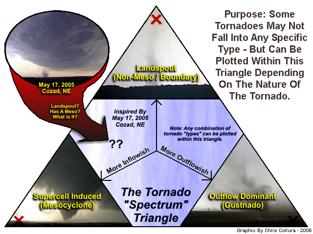
* What exactly categorizes tornadoes into their categories? We hear the terms "landspout", "gustnado", and "true supercell tornado", but many tornadoes may fall into more than one of these categories. After a small tornado was intercepted back in May 2005 near Cozad, Nebraska, my group and I saw it as a landspout, but also had a weak mesocyclone associated with it. So in the dusty chase van rear window we all drew a triangle, with each three major tornado "types" at the corners of the triangle. To settle the dispute, we plotted the tornado we just saw on the left side of the triangle between the "landspout" and "supercell" (mesocyclone) tornado types but farther away from the outflow-dominated "gustnado" type. The "tornado type triangle" was born! In the diagram above, highly refined from the "dusty rear window" version, shows how to use the diagram, and where the "Cozad, Nebraska" landspout / mesocyclone combination we decided on was plotted in that triangle.
STORM CHASING ARTICLES
This section contains some of my commentaries regarding storm chasing. Feel free to browse through these entries, some based on true stories.You may find them quite interesting.
A chase expense story ... Three people embark in two separate chase vehicles from Dallas, Texas to Kansas City, Kansas. The trip is about 600 miles round trip. The first two, Jeff and Dave, drive a V6 Ford Ranger with 18 MPG while the third, Tom, drives a V8 Dodge Ram with 10 MPG. Jeff and Dave spend the night in a Super 8 Motel for $40 a night while Tom stays across the street at the Raddison Suites for $100 a night. The next day, Jeff and Dave drive 150 miles with Dave's forecast and get a nice video of a storm northwest of the city. Tom, lacking any input as with Dave and Jeff, decides to split and go southwest of town, driving 100 miles, and sees nothing. He goes 100 miles north after hearing about the storm Dave and Jeff found and gets there too late. He "busts" and drives 50 miles back to town. Both chase teams begin the drive back late that night. Jeff and Dave take turns driving. Tom nearly falls asleep behind the wheel and stops at a small "roach" motel near Elk City, Oklahoma for $25 a night. By noon the next morning, Dave and Jeff are back in Dallas, rested and watching their video. Tom just returned and is still tired. Now we DO THE MATH. Jeff and Dave drove 600 miles plus 150 chasing for a total of 750 miles. Tom drove the same 600 plus an extra 25 for the Elk City Motel plus 250 for his chase, a total of 875 miles. Jeff and Dave spent $40 on accomodations while Tom shelled out $100 for the first night and $25 for the second, a total of $125. Jeff and Dave used about 42 gallons of fuel which is $62.50 at 1.50 per gallon. Tom used about 88 gallons which translates to $132.00. Since all three ate at the same places, well add $20 each for meals to all three members to get the final totals. Jeff and Dave spent a total of $122.50 while Tom spent a total of $277. Splitting the costs, Jeff and Dave each spent only $61.25 while Tom burned himself out and spend $277, over four and a half times as much! The moral to the story: Split your costs, chase with a partner, and focus on the chase and not the luxury.
Road rage and rushed storm chasing don't mix ... As you probably have read about the pitfalls of chasing thunderstorms in cities or heavily populated areas. These writings warn about missing a storm or simply pulling all your hair out over rush hour traffic jams and school speed zones. If you are really LUCKY, you will find a good storm in a city, but your escape route may be blocked ... Ouch! I have had a personal experience in my first days of storm chasing with road rage in Fort Lauderdale, Florida. I remember a really good multicell storm with a nice shelf cloud coming up in Broward County moving East. I was flying north on Interstate 95 until I reached a horrible traffic jam in Pompano Beach due to construction and rush hour. It was about 4 PM, in June of 1989, when I-95 was being widened. Since this happened after a long period of SDS and no storms, and I was so obcessed with catching this one that I started driving to the right on the emergency lane. I watched the mouth-watering storm intensify and start moving East by 4:30 PM. Since the ocean was only 4 miles to the East, I knew this was only a one shot chance. The storm supposedly contained hail and high winds and was capeable of producing waterspouts. After an AGONIZING crawl for a mile or so I decided to get off at Sample Road and go East. Everyone was doing the same thing. Now the emergency lane was also jammed with people improvising routes as well. I was infuriated. I was half on the grass and on of the right side of the off ramp. I realized that a long traffic light was complicating things up ahead and realized that what I was doing was not going to get me anywhere. The storm began moving offshore and a large lowering was barely visible above the buildings to the East. "Damn It! I am MISSING this storm! Oh f---, sh--, bi---, @#$!" Finally I signaled and pulled in front of a red Camaro who I thought was letting me in. I was so mad about busting that I didn't even realize how fast the car was going. It skidded, just missed the rear of my car, also a Camaro, and laid on the horn for at least 30 seconds. The car continued to the left and got along side of me as the rain (from weaker cells behind the storm) began pouring. Through the rainy window I see this woman totally hysterical with here mouth going a mile a minute with words I don't dare want to mention online. She had not one, but TWO middle fingers cris-crossed and shaking. She rolled down the window and stuck her fingers and gestures out into the rain shaft as the long traffic light admitted only a couple of cars every 2 minutes or so. The driver, probably the woman's boyfriend, just retained a cool hand and let the woman do all the "work". I continued to hear the words "F---en a-- hole!" and "You son of a B----, learn how to drive!" a few more minutes until getting through the light. By now it was 5:15 PM, and I had to be to work at 5:30 (pizza delivery back then). The storm was long gone and I missed every part of it. Afterwards, I realized that what I did put myself and others in danger. Don't rush to a storm, especially in a city or through rush hour. No matter how bad or good a storm is, it is not worth the frustration and risk! With all the incidences of roadside violence and shootings, all I got was some foul language and an couple of obscene gestures. Other people have not been so lucky.
Capacitance ... A lightning storer and joker! This write up is regarding experiences with the rather tricky things capacitors can do. During a chase in the Midwest US this spring. One member of our chase team had his digital camera lock up, That's right, just lock up like when a computer freezes and needs to be rebooted. The obvious thing is to power the computer, or any digital unit down, and it should come back up in its default state. In the case of a digital camera, that means taking the batteries out, wait 5 or 10 seconds, and put them back in. The camera was locked up, no buttons on it responded, not even the on or off button. He took the batteries out and waited at least a minute. The LCD screen stayed lit the whole time, including the last frame captured! After playing around for about two or three minutes, we could not get the camera to turn off, even with no batteries in it! Finally the camera "magically" began working again after we put the batteries back in. It was never turned off. I was baffled, how could this be? Well I was inspired by a CG lightning strike that just occurred that moment from a distant anvil cloud to the ground. A thunderstorm STORES a static charge, as I learned many times years ago in science and physics class. This is called capacitance, or storing of a charge of electricity until it is discharged. A thunderstorm, ofcourse, is a generator and storer (capacitor) in a way. This led my thoughts back to the camera. There had to be a small capacitor in the camera holding a charge long enough for the camera to function, even though it was locked up. After a while, the capacitor discharged and the batteries once again took over, and the default settings returned to the unit. A very similar and frustrating experience happened a long time ago back in 1988 when I was working at my first part-time job doing deliveries. I wore a beeper so that my boss can beep me so I could rush back and go on a delivery to a customer if I was running errands or doing mail and store runs. One day when I reported to work I needed to deliver some store coupons and took the beeper in case a customer calls my boss with an order. I turned the beeper on, it vibrated, and beeped several times while displaying a "Ready" message on the flashing LCD screen. "Great, it works." I said. My boss replied "Hurry back if you hear the beeper." Three hours later I finished delivering the mail and coupons to a neighborhood. I wondered why it was so quiet with no orders until I pulled back into the parking lot of the store. My boss was literally jumping up and down screaming. His face was red as a beet and he was running all around in a rage. He began to scream and yell and I explained to him "You didn't beep me!" He snatched the beeper out of my hand and ran back in the store with about 10 delivery orders hours late. He opened the beeper and showed it to me by holding it a few inches from my face. "Do you see? No battery in the beeper! Didn't you check to see it it even worked?" I was shocked. Why would the beeper power up and work fine? Then the word "capacitor" came to mind. It held a charge long enough to trick my boss and I into thinking the beeper was working. After it was on for a few minutes, the capacitor discharged and the beeper was useless. My boss continued to rant and rave, eventually smashing the beeper to pieces against the concrete floor. We lost a lot of business that night and the store eventually went down the tubes because of it. So what does a thunderstorm anvil producing CG lightning, a digital camera that won't turn off, and I beeper that fooled my boss into bankruptcy have in common? Capacitance (100 uF).
The "Cap Rock" country ... The remote areas of western and central Texas has always been a place for tumbleweeds, lone ranches, and cowboys ... Many storm chasers also congregate there in the late spring for severe thunderstorms and tornadoes. One may wonder why this region has such a high potential for the development of strong and severe thunderstorms. The dynamics of this area does indeed affect storms. The Cap rock country in West Texas has a gradually upsloping geography. To the west is the higher deserts of Colorodo and New Mexico, to the east is the lower coastal plains extending to the Gulf of Mexico. From the Gulf to the western sections near the Texas west border, the elevation GRADUALLY increases from sea level to about 3,000 feet, or more. This is gradual, and the terrain appears to be flat like a plain, but in reality is a slope so gradual you can't really see it with the naked eye. The elevations in these areas can be looked at on the US Geological Surveys web site. Anytime there is an up-slope wind, as with a southeasterly wind (Favorable for storms), air is lifted from the Gulf into the Cap rock area. Low level Gulf moisture is advected (transported) into this area. During its journey, the moist air passes over hot sun-baked terrain, thus "cooking" it to very high CAPE levels. Usually, elevated and high base cumulus clouds develop from this lifting as the air reaches western Texas. This terrain enhanced convection is called OROGRAPHIC instability. In addition to the upslope wind theory, the lapse-rates also are affected. Imagine the 700 MB (About 10,000 feet or 3030 meters) temperatures normally about 40 degrees F (Roughly 5 Celsius) around late May over Texas. Temperatures at the surface, for argument sakes are 90 degrees at BOTH the Gulf coast and Cap rock country. Near the Gulf, 90 at the ground and 40 aloft gives a 50 degree drop in temperature in 10,000 feet, or a lapse rate of 5 degrees F every 1,000 feet. In the cap rock country, with an elevation of 3,000 feet, the same 50 degree temperature drop occurs in only 7,000 feet, or a lapse rate of over 7 degrees F per 1,000 feet ... Much more instability than near the gulf coast, this is not even considering any moisture in the air! Now we have steeper lapse rates, higher CAPE, and a pre-existing upward tendancy of the air. All that is needed now are some important "mediators" such as a weak CAP, so storms fire late in the day, and an INITIATING factor, such as a DRYLINE, an outflow boundary, and / or a front. Drylines are most common in western Texas near the cap rock country anyway - yet another reason why this area is so volatile. When things like this come together, such as a dryline punching out over west Texas, combined with the "juiced" or "loaded-gun" of the atmosphere in place, storms WILL fire ... And they will fire strongly. In summary, the unique geography of the cap rock country does indeed affect storms in West Texas. It is the orographic effects of an upslope wind that enhances CAPE and lapse-rates and the proximity of this region to the dryline as well as disturbances moving in aloft from the Rocky Mountains.
Unique supercells and storms with supercell characteristics ... Many meteorologists and storm chasers study the development, evolution, and demise of supercell thunderstorms and the unique weather they produce. Supercells are produced by conditions in the atmosphere that promote rotation at the storm-relative level. Such factors are an abundant supply of warm, moist, and extremely unstable air coupled with some sort of shearing mechanism such as directional wind shear with height. MOST supercell storms are seen in the central United States and form in regions of convergence, usually fronts or drylines, and come to be via a shearing element, usually a strong jet stream aloft. There are other types of supercell storms that develop in much different environments and can occur in regions far from the US Plains. First of all, supercell thunderstorms need some sort of twisting motion in the atmosphere to cause the rising air in the thunderstorm updraft to rotate, forming a mesocyclone. This "spin element" does NOT ALWAYS have to be a jet stream aloft like most supercells are associated with. One interesting scenario for such supercell storms are in regions of strong convection associated with tropical systems, such as hurricanes. A good example was hurricane Gordon in September 2000 near Florida. When the hurricane, with 75-MPH winds, was moving to the NNE just West of Tampa, Florida, the entire state to the east was under the forward right semi-circle of the storm. In this region, the winds at ground level were from the southeast at anywhere from 20 to 30 knots. About one mile up, the winds were southwest at over 50 knots. Upper air outflow from the top of the hurricane at over 30,000 feet, which is clockwise, was from the northwest at almost 100 knots. Cloud cover and light rain ahead of the advancing system kept thermodynamic profiles at bay, with a CAPE of less than 1000, however, an advancing feeder-band (squall line type spiral band) was advancing from west to east ahead of the advancing hurricane. This line of sorms had a shear-axis associated with it, where the SE surface winds changed to SSW behind the line. The forcing associated with the convergence of this feature allowed thunderstorms to fire along, and most importantly, AHEAD of it. With the proper shear profiles and lift in place, numerous HP supercells developed, some of which had confirmed tornadoes with damage. This setup is suprisingly common on the forward-right semicircle of strong tropical systems. Some behavior of such supercell storms can be inconsistent with their cousins in the Plains. Most Plains storms are in the westerlies wind pattern, and move to the NE (Or SE). In tropical systems, such storms may move in the direction the prevailing winds happen to be from in that part of the tropical cyclone. In the Gordon example above, most cells moved to the north, but during hurricane Georges in 1998, some supercell storms with tornadoes were in a region of winds prevailing from the NE, and moved TO the southwest! These storms are also rather short-lived and may not produce much hail, however, they can produce TREMENDOUS amounts of rain, wind gusts far greater that the prevailing winds of the tropical system, and of course, tornadoes. Hurricane Erin in 1995 was another example. The storm with 80-MPH winds was over central Florida. Far from its center, an HP supercell storm fired in the Bahamas where the prevailing winds were less than 25 MPH. Wind gusts with this storm, assumed to be straight-line, exceeded 115 MPH. Another region where tropical-based thunderstorms can acquire supercell characteristics is right in the center of the circulation. This usually happens in tropical systems that are weak but rapidly strengthening. A stronger tropical system like a hurricane will usually have too much subsidence in its center for such convection. Since such storms develop right in or near the central "hub" of the "wheel" (vort-center), they simply rotate, in the same manner a person sitting at the center of a merry-go-round would at a playground. Once rotating, a powerful updraft can develop and farther enhance the circulation of that cell. These rare type of supercells were observed in Hurricane Debby off Puerto Rico in August 2000. Debby undergone a strengthening trend when this supercell storm was in its center. When the short-lived HP cell dissipated, the intensification of the storm relaxed, confirming a rapid evacuation of air from the low levels to aloft (strong updrafts) with the supercell. Another interesting feature with tropical convection are meso-vortices that develop in the centers of developing tropical systems. These are not supercells, but possibly outflow from the neighboring thunderstorms in the eyewall interacting with the circulation center of the system. Such supercell storms in and around tropical systems are quite rare and deserve farther study. Outside of tropical systems, certain types of supercell or supercell-like storms can develop. A squall line of thunderstorms often is outflow dominant, however, cells at the end of the line segment, or where there are breaks in the line, tend to behave like supercells. An example is the cells on the north end of an eastward-moving squall line. The outflow is stronger south of this region and much lighter north of it. Cells in this region can have a tendency to rotate counter-clockwise (Northern Hemisphere), even if the wind shear profiles don't suggest supercells. Squall lines and thunderstorm storm clusters are very common in many regions of the world and all are possible of spawning such supercells. The threat from such storms is real, especially in tropical regions and developing parts of the world where no one even knows what a supercell is, and worst of all, where poorly built structures cannot withstand the wind and rain dynamics with such storms. A land falling hurricane can very easily cause a tornado outbreak in Central America, for instance. Another grim instance would be a squall line striking parts of Africa and spawning an HP storm that destroys a small village. More realistically, when hurricane Georges crossed the Dominican Republic in 1998, a persistent cell near the center of the system interacted with the mountainous terrain of the island. Regions near this cell sustained extensive wind damage and mudslides from over 20 inches of rain in just hours. The cell was at the center of circulation, possibly an example of an HP supercell mentioned above.
Storm chasing and relationships ... Explosive emotional outbreaks possible. "Get out! It's Over!", "When you are storm chasing the last thing you think of is me!", "What's more important, storms or me?", "Goodbye! Now you can hang your supercell pictures where our wedding pictures were!", "I won't be there when you come back!", "Go, and if you kill yourself, it's your problem!" ... How many of these chilling and gut-wrenching phrases sound familiar? Well, many storm chasers have run across someone, whether a significant other or not, who has labeled them as "crazy", "stupid", or "inconsiderate". These things really hurt, trust me, I have had my share of them. First I will try to explain what I know based on my experiences. The one thing to consider is the differences between a man and a woman when it comes to storm chasing. Storm chasing is like HUNTING. It is boring, but when you catch something, the excitement justifies the boredom. It also has an inherent risk to it. Like hunting, storm chasing is taken up more by the male community than females. Some women are into storm chasing, just like some are into hunting, but it is a minority. You can read a great topic on "Women and Storm Chasing" at the STORMTRACK web site. The typical regime is that the husband, or boyfriend, will go out storm chasing while the woman usually does not come along. This can cause some "nothing in common" issues as well as the woman being worried sick over his safety. Sometimes, the woman may not be able to cope with this stress and rather be alone. Another example of this was a person who was a volcanologist and traveled around the world studying volcanoes, another activity with an inherent risk. He wound up in the hospital after falling off a ledge with moderate injuries. After his recovery, his wife locked away his passport when another eruption was occurring in the Philippines. Eventually, his wife let him go, after all, he worked with the Geological Survey and this was part of his job. When he returned, uninjured and in high spirits, divorce lawyers and grudges greeted him. His wife admitted that she loved him, but could not deal with the possibility of him not coming home when he went on the expeditions. Personally, a chase partner of mine had his fiancee take his chasing money, for a trip to the US Midwest, and spend it on herself. Her intention was to keep him from going, but it failed because other members of our chase group loaned him the cash needed for the trip. There is one thing I need to say, and that is COMMUNICATION. I can stress than anymore. When you meet someone, tell them what you do. Tell them why you chase storms. Most of all, bring up encouraging statistics about your hobby - such as that storm chasers rarely get hurt when many people are killed by the storm they are chasing. This is because storm chasing requires knowledge and training to study natures violence in a SAFE as possible manner. This is a very important topic to discuss with your friends and loved ones. Another hint, if you meet someone and they tell you "That's crazy, I would never do that!", or "I think that will be a problem if we get serious.", then DONT get "serious" with that person! Preferably, someone with a similar interest with nature or extreme sports, for example, a skydiver or whitewater kayaker, would be much more empathetic and understanding of your hobby. Another important thing is that if a problem does arise, talk about it. The most important thing is to talk it out and fix the mis-understanding. The WORST thing is to keep your mouth shut and not say anything when you should ... One chase partner of mine had his girlfriend leave him in such a rage that he videotaped her to show her how hysterical she was! She blew up so dramatically simply because she "held it in" so many times, like a CAP in a high CAPE environment, she eventually "exploded". If the talking and up-front informative does not work, there is counseling. Storm chasing is not a "crazy" thing. It is something you and your loved ones should be proud of. Never be ashamed to see a marital counselor or the like, after all, you are only getting help, and it is wrong if you don't get help! In my case, it is important to be open and positive about your hobbies. Always talk about the good points. Being a skydiver as well, I always talk about how high I jump from and how beautiful the sky is up there. I never bring up issues about accidents I witnessed or risks involved. Remember, these things scare people and cause people to worry. Tell everyone, especially when you just meet them, what you enjoy to do, let it be your family, boss, fiends, and loved ones. If they don't understand, it is their "opinion" and that deserves a degree of respect too.
Tornado chasing versus tropical cyclone chasing ... We have all heard of storm chasers that chase tornadoes AND tropical cyclones such as hurricanes. I can name a few right off the top of my head, even myself! Does this mean that these two types of storms to chase are similar? No way. A tornado (or tornado producing supercell thunderstorm) and tropical cyclone are two very, and I mean very, different animals. They also require totally different methods to chase and forecast them. First of all, tornados normally develop over land, and occur late in the day when the atmospheric heating is at its peak. Tropical cyclones develop only over warm ocean waters, regardless of the time of day, and rapidly dissapate over land. In fact, sometimes tropical cyclones intensify more at night than during the day due to the cooling of the cloud tops enhancing the lapse rates inside the storm. With a tornado chase day, they day begins with forecasting and preparations on where storms MIGHT develop. A tropical cyclone chase day forecast is for an EXISTING storm that is anticipated to strike a certain area, usually a coastline. Preparations for tropical cyclone chasing often are spent getting into the target area, in the same manner as a target area for expected thunderstorms. The primary goal with a tornado chase is to simply document the tornado, if it develops, from a place that provides the best view without compromising safety. Normally, a chaser should not have to drive through (core punch) the thunderstorm producing the tornado (and certainly not the tornado itself). With a hurricane chase, the chaser cannot see the "vortex" as with a tornado because it is many times the size. Conditions in a hurricane or tropical cyclone can be as bad, if not worse, than driving through a monster HP supercell. One can expect winds at or over 74 MPH, 10 or more inches of rain, and flooding in a hurricane chase. Tropical cyclone chases often involve driving (or "punching") through the most dangerous part of the storm. Visibility will often be zero and a chaser will get buffeted by heavy winds. The main goal of a tropical cyclone chase is documentation of the storm, as it is with tornado chasing, with SAFETY still a priority. Tropical systems are given a name when their sustained winds reach 38 MPH, where they are called a TROPICAL STORM. At 74 MPH or above, they are called HURRICANES in this part of the world, and like tornadoes, they are rated in intensity from category 1 to 5. Most hurricane chases involve tropical systems with winds under 110 MPH (category 2 or less), stronger storms are more difficult and require farther planning due to the extreme inherant danger. Serious safety considerations must arise when chasing tropical cyclones considering issues with storm surge, flooding, road closures, etc. Remember that a tornado only affects a small area where a powerful hurricane can inflict similar damage over a very large area. Hurricane Andrew back in 1992 was a category 5 storm with 165 MPH sustained winds. Regions over a 40 mile wide path received damage similar to a strong F-3 (or even F-4) tornado (peak winds in hurricane Andrew unoficially reached 212 MPH)! I chased Andrew and it was not an easy chase. Since it was too dangerous to drive into, I observed the storm from a shelter. Much of the school I was staying in was destroyed and many cars in the parking lot were flipped. Another note on tornado vs tropical cyclone chases ... We all know that storm chasing involves long drives, but you haven't experienced the true determination until you chased a hurricane. In a thunderstorm chase, you may drive hours to get into your "target" area and often get a hotel after chasing to stay the night or simply drive back home. A hurricane chase often requires a similar long drive, or even a flight to get to your target area! Often you will go a full 24, or even 36, hours without sleep while dealing with the core of the tropical system you are chasing. Hotels, gas stations, and stores often close and power is often the first to be disabled by the storm. Tropical cyclone chasing is a very different activity that is carried out by only a small handful of avid storm chasers who also chase tornadoes. It requires a totally different "game plan" and requires extensive knowledge of tropical meteorology in a more crucial sense than that of a tornado chaser.
Vertical momentum ... Ever wonder how fast air is rising into the sky during a developing thunderstorm? What about during a Tornado? Here I will try to explain what I know about vertical wind speeds in the centers of natures most violent storms. Here I will start with the basics. Convection is simply the rising of warm air and the sinking of cooler air. To have clouds, there must be rising, warm and moist air (compared to air surrounding the air "parcel") where the moisture condenses at a certain altitude, forming the cloud. This rising air may be a thermal, from the uneven heating of the earth's surface, or forcing / convergence caused by a front, mountain range, or inflow of air into a low pressure system. Another important thing is that more heat energy is transferred to this air parcel as the water vapor condenses (or freezes). This makes the air parcel warmer and causes it to rise faster. About 540 calories of energy are released as a single gram of water condenses! When each gram freezes, an additional 80 calories is released. The small fair weather cumulus often have updraft speeds of about 5 MPH. The really impressive updraft speeds occur in developing thunderstorms and especially in supercells. In a general (non-severe) thunderstorm, the development and early-mature cycle is when the updraft is strongest before downdrafts begin to disrupt the storm. Typical speeds range from about 15 to 30 MPH, or roughly 1,200 to 2,500 feet per minute. At this rate, the relatively "weak" storm reaches a height of about 30,000 feet in 15 minutes, and may last only a half hour. Severe thunderstorms, require much stronger updraft speeds and depend on the type of storm. Multicell lines generally have weaker updrafts than multicell clusters but are arranged in a "curtain". The updraft speeds in a multicell line storm are a bit stronger than the single cell general storm described earlier. Multicell cluster storms often have updraft speeds around 60 MPH in developing components, or about 5,500 feet per minute. This is quite fast, keeping in mind that most general aviation aircraft can only climb up to 3,000 feet per minute (200 Super King Air). This is also why pilots should NEVER try to "out climb" the top of a developing thunderstorm. The strongest updraft speeds lie with the most intense kind of thunderstorm, the supercell. A supercell is a "continuous cycle" storm, meaning that it has an updraft side and downdraft side at the same time which are separated from each other allowing the storm to last much longer than 30-45 minutes. The updraft of a supercell also has a broad low and / or mid-level rotation (mesocyclone) which my further boost its speed. Supercell updrafts generally are stronger than 50 MPH, but 70 or 80 MPH is more typical. In the Great Plains of the United States, supercells often produce baseball and grapefruit sized hail (not to mention tornadoes) because of the extreme speeds of the updrafts within. Such updrafts have been known to reach 150 to 175 MPH, or about 12,000 to 15,000 feet per minute! No aircraft except for military fighter jets with afterburner power could climb at these rates (for example, the F4 Phantom and Lear 35 Jet both have maximum climb rates less than 8,000 feet per minute). This is why a supercell can literally go from "blue sky to tornado" in a "New York minute". At 15,000 feet per minute, an air parcel will go from ground level to 45,000 feet in only 3 minutes! An experiment was done via special weather balloon to find out how quickly a supercell updraft will carry it. The device was released into the inflow side of an HP supercell in the Great Plains and ingested into the storm. Only 2 and a half minutes later, the balloon was in the anvil of the storm. It rode the high-velocity core of the storm and gave vital information on the structure of the storm and internal dynamics. Supercell storms are the most dangerous to aviation. Visibility and wind-shear are the most obvious threats at low levels, however, the updraft and mesocyclone is usually strongest at 20,000 feet. A commercial airliner flying though such a storm will most likely have its wings torn off, and this has happened to planes trying to fly through severe thunderstorms. Another pilots horror story was an L1011 trying to fly through a "hole" in a multicell cluster of severe thunderstorms. Invisible to the pilot, was that baseball sized hail was falling through that "hole" in the storm, and serious damage to the aircraft was sustained (cracked windows, cratered leading edges of wings, and crushed engine nacelles). The most amazing stories come from several incidents of people who were unfortunate enough to parachute into a thunderstorm. Imagine a 100 MPH updraft, your parachute is descending at 10 MPH ... Do the math, this means you will go back UP at 90 MPH! In the book "The Man Who Rode The Wind", a true story of a pilot who ejected into a thunderstorm at 45,000 feet is described. He ejected from an F8 Crusader and descended into the developing storm until his parachute deployed at 10,000 feet. He became caught in the storm updraft and actually re-ascended under his chute to 26,000 feet. Thin air caused him to pass out and the cold caused intense frost bite during his ride up and down the inside of the storm. The water inside the cloud nearly made him drown in mid air. He was constantly slammed around by the extreme turbulence and at one point his body appeared to be ABOVE his parachute. Finally, the storm weakened and he descended back to earth 30 minutes later. A person found him in a field, severely injured but alive. This storm was not even a severe storm, just a strong summer 30-45 minute long storm. Imagine if this storm was a supercell. Another incident happened in Germany where 5 parachutists fell victim to a thunderstorm updraft. All landed covered in ice after their wild ride ... yes, they became the "cores of hail stones". Only one of the 5 survived. Other strange phenomena occur when a tornado picks up debris and it becomes involved with the main updraft of the supercell. This accounts for "rains" of frogs and fish if the tornado passes over water and dumps them far from their point of pickup. Some fish encased in ice occured with one such incident. Other objects such as appliances, roof shingles, insulation, plants, even a computer floppy disk and a desk have landed miles away from a violent tornado touchdown.
HTML File "schcom.htm" - Developed By Chris Collura
To Return To The HOME Page Of This Site Click The "INDEX.HTM" Link Here!