
| This section contains a detailed cloud "atlas" for various types of clouds and their variants with symbols. This section also contains descriptions of the different types of thunderstorms and a breakdown of different types of supercell thunderstorms. This section should be useful for a cloud type field reference as well as informative for thunderstorm study. Note - This page may take a while to load on some SLOWER connections! |
What is the definition of a CLOUD? A cloud is simply a suspension of particles or droplets of one substance in another. In more abstract terms, the suspension of water droplets and / or ice crystals in the air. This suspension, varying by density and altitude, has the ability to reflect, diffuse, or refract light in different ways resulting in the white, grey, or other colors we see when we look at clouds in the sky. Clouds are not water vapor. Water vapor is a gas and is invisible. When water condenses or freezes, it becomes visible simply because the different way light behaves when it strikes the water droplet or ice crystal. Millions of these particles, often less that 1/1000 of an inch in size, suspended in the air form what is known as an AEROSOL. HAZE and SMOKE are also types of AEROSOLS and fall into the cloud category.
High Clouds - The "high" cloud class covers any cloud that is 20,000 feet, or more, above the ground (AGL). Such clouds are often composed of ice crystals (sometimes supercooled water) due to this great height, even over tropical regions. Upper air weather systems and gentle lifting produce high clouds.
|
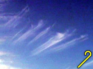
This picture shows the thicker version of CIRRUS clouds with the variant name FLOCCUS. These high clouds are thicker than the "fibratus" form of the same cloud and appear whiter and denser. They form from gentle lifting and freezing of water vapor at high altitudes. Composed of ice crystals. |
|
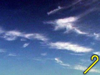
This is a picture of the familiar CIRRUS UNCINUS clouds, or "mare's tale" cirrus. This variant is the thin, wispy, and delicate appearing high cloud commonly referred to as "cirrus". These are the highest type of clouds, always above 20,000 feet, and more often higher. They are composed of fine ice crystals and form from slight lifting of high-altitude air with freezing of water vapor. The trails of the cloud elements are formed from the stretching of regions of ice crystals in suspension by the upper air wind patterns. The "hook" shape of this cloud variant gives the name UNCINUS. |
|
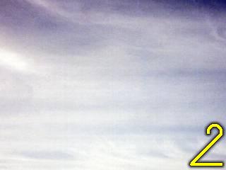
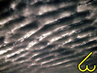
This picture shows CIRROSTRATUS clouds high over Florida one day after the passage of a strong cold front associated with the "Storm of 1993". The cirrostratus clouds are the "milky" white regions in the center of the picture. There are some other cirrus cloud types in this picture (note the "floccus" variant of the clouds in the lower right side of the picture). These clouds are always composed of ice crystals and develop in gentle but steady lift at very high altitudes (over 20,000 feet). The streaks in the cirrostratus clouds in this picture are caused by an unusually strong jet stream near the level of these clouds. |
|
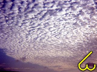
This picture shows CIRROCUMULUS UNDULATUS clouds high in the sky over Florida. They are very similar in structure to altocumulus, but are over 20,000 feet AGL and comprised of ice crystals (maybe some supercooled water). They form very small "puffs" and wave-like patterns as with altocumulus. These clouds form from gentle lifting of air at high altitudes with mild instability. The name UNDULATUS comes from the arrangement of the cloud elements. |
|
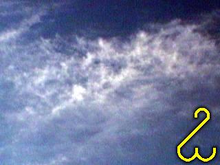
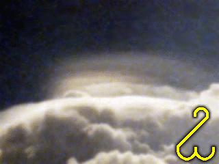
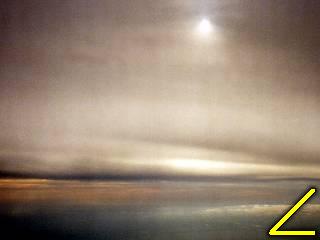
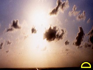
These are CIRROCUMULUS clouds developing at the leading edge of a strong thunderstorm updraft at exceptionally high altitudes. The cloud here is the thin, irridescent cloud in the center of the picture, and NOT to be confused with the billowing cumulonimbus clouds in the lower portion of the photo. This cloud is also called a PILEUS cloud, and is formed when stable moist air is forced upward by some other lifting mechanism, such as a mountain wave, or displacement around an updraft as in this picture. The variant name LENTICULARIS is latin for "lens shaped" because of the round shape of the cloud. Almost always comprised of ice crystals. |
Mid Level Clouds - The "mid level" cloud class refers to clouds that are at altitudes between 6,500 and 20,000 feet above the ground (AGL). This region of the atmosphere is sort of a "transition zone" between the lower and upper atmosphere and "mixing" (convection) depends on weather systems moving along as well as available moisture. Generally composed of liquid water in the lower portions near 6,500 feet but ice crystals (or supercooled water) in the higher portions above 18,000 feet, depending on the season / freezing level.
|
These are ALTOCUMULUS clouds with slight vertical development and in small cloud elements, usually at least as tall as they are wide. The smaller cloud elements produces a "mackerel" or "chaotic" sky effect. In this picture, the "mackerel" sky effect can be seen. This type of cloud develops from increasing instability aloft, usually in a restricted shallow elevated layer of moisture. The variant CASTELLANUS comes from the appearance of the cloud elements. Mostly comprised of water (or supercooled water) droplets. These clouds often develop in increasingly unstable environments. |
|
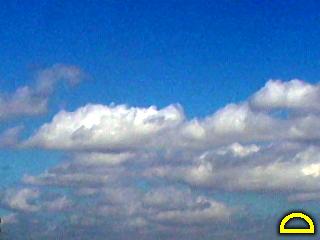
These are ALTOCUMULUS clouds with little vertical development but arranged in rows making a "Herring Bone" pattern. These clouds were formed in steady winds aloft along with slight instability, usually in a restricted shallow elevated layer of moisture. The variant UNDULATUS comes from the flattened and uneven appearance of the cloud elements. Mostly comprised of water (or supercooled water) droplets. The "Herring Bone" pattern comes from the row-like arangement of the cloud elements. |
|
These are ALTOCUMULUS clouds with rather high vertical development. They often develop in regions of high instability aloft (but stable at the surface). In some cases, these can develop into cumulonimbus (elevated thunderstorms) with the base above 6,500 feet (AGL). The vertical development coins the variant name CUMILIFORMIS. Mostly composed of water (or supercooled water) droplets. |
|
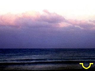
This is a picture of ALTOSTRATUS TRANSLUCIDUS clouds. These are high mid-level clouds (over 10,000 feet AGL) that take the form of a blanket or layer. In this picture, taken from an aircraft, the sun appears "watery" as viewed through frosted glass, giving this variant name TRANSLUCIDUS to this type of clouds. Note the cloud "cross section" and base across the bottom-center of the picture showing the "blanket" structure of these clouds making them different from altocumulus. These clouds form in gently but steadily rising air at mid levels and can be composed of water droplets, supercooled water, or ice crystals. The also may produce precipitation that does not reach the ground (virga). |
Low Clouds - The "low" cloud class refers to any cloud that occurs within 6,500 feet of the earth's surface (AGL). Most weather and atmospheric "mixing" (convection) occurs in the lower atmosphere and abundant moisture makes low clouds the most common types of clouds. Low clouds can even be "on" the ground as with fog or fairly high up as with stratocumulus and cumulus near 6,500 feet. Generally composed of liquid water (or supercooled / frozen if above freezing level depending on the season).
|
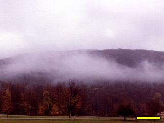
This picture shows low stratus clouds in the Catskill Mountains in New York. These are low, blanketed type clouds that are very low to the ground. In this picture, the lower layer is only 200 feet AGL while the next layer is about 500. The mountain is about 500 feet above the valley floor. These clouds form when moisture in air close to the ground condenses due to cooling of the air. Almost always composed of water droplets. |
|
This picture shows low and broken STRATUS clouds called FRACTOSTRATUS. These clouds are also called SCUD clouds if they are below another deck of higher clouds as in this picture. The Latin word "FRACTUS" means "broken". These clouds form in regions of low-level moisture and may get their "broken" appearance from strong low-level winds or rain falling through the clouds. Almost always composed of water droplets. |
|
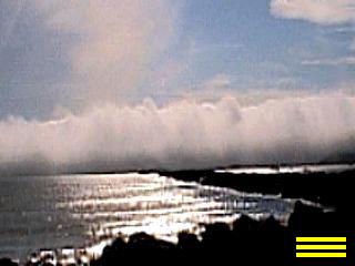
This is a picture of the famous "marine layer' off the coast of northern California. The marine layer is simply a thick bank of fog that develops over the cool waters of the Pacific Ocean. FOG is nothing more than a STRATUS cloud that is at ground level. There are two main types of FOG, radiation fog, where air cools at night and its moisture condenses, and advection fog, where the fog transported by prevailing winds as in this picture above. Fog can also be formed when a moist surface is much warmer than the air above it forming steam fog. Almost always composed of water droplets (ice fog is rare but does occur where the composition is ice crystals). |
|
This is a picture of STRATOCUMULUS UNDULATUS clouds over the warm waters of the gulf stream off Florida after the passage of a strong cold front. In this case, the 75 degree sea-surface meets 45 degree air and the shallow modified warm layer rises before reaching a temperature inversion. The result is irregular mixing over a broad area in a rather shallow low-level layer which produces cumulus like clouds but with flattened tops and limited vertical development. In this picture, they only form over the warmer waters because of more abundant moisture. The term UNDULATUS comes from the appearance of the clouds. Clouds mainly composed of water droplets (or supercooled water in some cases). |
|
This picture shows the CUMULUS cloud type but rather broken or ragged cloud elements making the name FRACTOCUMULUS. These are low clouds that often develop in regions of strong winds or where larger cumulus elements begin to break down late in the day or when instability weakens. The variant FRACTUS comes from the word "broken". Comprised mostly of water droplets. |
|
This is a picture of fair-weather CUMULUS HUMILIS clouds. They form in fair, warm weather and are caused by rising scattered "thermals" of air and moisture condensing at the level of the clouds. They do not grow very large and generally remain as they appear in this picture. Each cloud appears and dies as a cumulus "fractus" cloud before it disappears. Almost always composed of water droplets. The lack of vertical development gives this cloud variant name HUMULIS. |
|
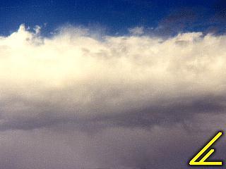
This is a picture of a layer of NIMBOSTRATUS clouds. These clouds are basically rain-producing clouds very similar in structure to stratocumulus. They are not vertically developed and rain (or precipitation) bearing giving them the name NIMBOSTRATUS from the Latin word "NIMBUS" meaning "rain". Rain can clearly be seen falling from the base of this cloud. Often formed when air is rising steadily over a broad area. Mostly composed of water droplets (may be supercooled and can also produce snow). |
Clouds Of Vertical Development - This class puts any cloud that is rooted (has its base) in one layer (low, mid-level, or high) and its top in the next layer above it, or is exceptionally "tall" in height. Mature cumulonimbus clouds are often present at all these levels (example, their base may be at 3,000 feet while their top may be at 45,000 feet). These cloud types require a strong updraft of warm, moist air rising high into the atmosphere.
|
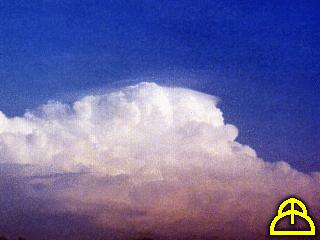
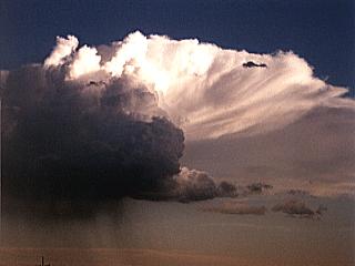
This is a picture of towering CUMULUS clouds that are bunched together and vertically developed, hence the variant name CONGESTUS. They develop in regions of deep instability and often grow into cumulonimbus clouds. They have rather strong vertical updraft speeds and can be composed of liquid water droplets, supercooled water, and even ice crystals suspended in their upper portions. |
|
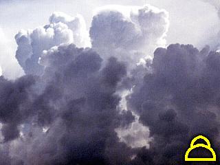
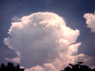
This picture shows a CUMULONIMBUS INCUS cloud. This is a very large cumulonimbus that has just reached maturity, with its base at about 3,000 feet and its top over 50,000 feet AGL! The INCUS variant of this cloud type does not yet have a fully developed anvil. Cumulonimbus clouds develop in deep moist and unstable air and contain water in almost all forms, liquid, ice, and supercooled. These clouds contain both powerful updrafts and downdrafts. They produce precipitation in the form of rain showers which can be extremely heavy, sometimes with snow or hail. |
|
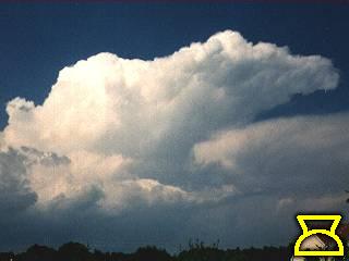
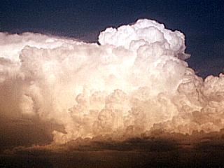
This picture shows a CUMULONIMBUS CALVUS cloud. This type of cumulonimbus has a well developed anvil which is being blown downwind by the upper level winds (to the right in this picture). This storm has a top over 40,000 feet high. The CALVUS variant of the cumulonimbus is determined by the formation of a glaciated anvil. Cumulonimbus clouds develop in deep moist and unstable air and contain water in almost all forms, liquid, ice, and supercooled. These clouds contain both powerful updrafts and downdrafts. They produce precipitation in the form of rain showers which can be extremely heavy, sometimes with snow or hail. |
Other Miscellaneous Clouds - This area of clouds is rather un-official and really falls into no "category" of cloud type. Examples of such are aircraft contrails, where moisture fron aircraft engine exhaust condenses or freezes at altitude forming a white "line" or trail, and other clouds that are often produced by or part of a larger classified cloud system (mammatus clouds for exmaple).
|
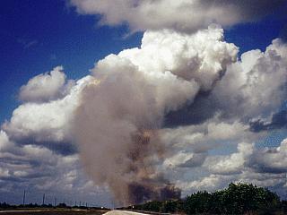
This is a picture of a rather informal cloud classification, PYROCUMULUS. All these type of clouds are are towering cumulus clouds that develop over hot rising air that has convected moisture to higher altitudes and condensed. In this case, the source of the hot thermal is a sugar-cane prescribed burn fire in central Florida. The cumulus cloud, also called a CAP CLOUD, can be seen above the smoke plume. The term 'PYRO" means "fire". These clouds can also be seen over any abnormal heat source, even smoke stacks, if the moisture is correct. Mostly comprised of water droplets (with smoke particles if smoke is drawn into the cloud). |
|
This is a picture of a high-altitude view of a PYROCUMULUS "cap" cloud rising above a layered, stratiform cloud deck. The puffy top of the cumulus "plume" can be seen "poking" above the stratocumulus clouds. Also note how the layered clouds around and downwind of the cumulus feature show a wave-like behavior, very much like a v-notch found at the top of a thunderstorm anvil. The cumulus cloud developed over a warm heat source, such as a factory smokestack or brush fire. The picture was taken from a Boeing 747 commercial airliner 38,000 feet over Germany in the winter. |
|
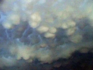
This picture shows MAMMATUS clouds on the underside of a severe thunderstorm anvil in the central United States. These clouds are actually part of the thunderstorm itself and are also called MAMMATOCUMULUS (or MAMMATOCUMULONIMBUS). They are produced by extreme turbulence aloft where lighter air in the thunderstorm's anvil or other cloud portion push down into the heavier air below creating the cloud element which gets its name from the shape of a women's breast, hence the name MAMMATUS. Composed mainly of supercooled water and ice crystals (sometimes water droplets). |
|
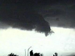
This is a picture of a WALL CLOUD, which is actually what is called an ACCESSORY CLOUD, that is, a cloud that depends on another larger cloud system to form (in this case a cumulonimbus). A wall cloud is a lowering of the base of a thunderstorm that is caused by the higher moisture convergence / dewpoints directly beneath the updraft of the storm. They are often signs of a strong updraft, therefore severe thundertorms. A rotating wall cloud forms below a rotating updraft and could hind tornado formation. The wall cloud in this picture was NOT rotating but was on the SW side of a severe thunderstorm (precipitation is to the far right of this picture and not visible, except for a rain "foot"). Composed of water droplets. |
|
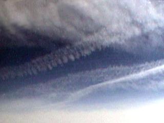
This picture shows at least two aircraft contrails high over the Tampa Bay area of Florida from a commercial aircraft. These are the common white lines we occasionally see crossing the sky from high flying jet aircraft. The CONTRAIL (or "vapor trail") is simply moisture in the jet exhaust stream condensing / freezing in the extreme cold of the upper levels. When most fuels (kerosene, aviation fuel, etc.) are burned, the exhaust gases contain carbon dioxide, unburned hydrocarbons, carbon, sulfur oxides, carbon monoxide, and the condensing water vapor. Contrails usually start out as water droplets that become supercooled and quickly freeze. The moisture and temperature of the upper air the aircraft is flying through is very important to the formation, and persistance, of a contrail - or even if one will form at all. The irregular "puffs" in the trails in these pictures are caused by wake turbulence of the generating aircraft. |
Thunderstorms - Thunderstorms are often classified into four main types. The types are single cell storms, where only one updraft element exists, multicell clusters, multicell lines (squall lines), and supercells. The single cell storm and supercell storms both have a single updraft, but the supercell develops in much different environments than the single cell storm and has very high updraft speeds, lasts much longer, and contains persistant rotation on a broad scale. The multicell cluster and line type storms both contain more than one updraft, but are organized in different ways (bunch of storms clustered in one area versus a line of storms).
|
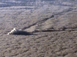
This is a picture of a SINGLE CELL thunderstorm over south Florida. Actually a true single cell storm is quite rare, but in this picture, a lonely updraft forms far from neighboring convection. The thunderstorm here was a PULSE TYPE severe storm and produced 55 MPH winds and marble sized hail as this picture was being taken. Such storms are very short lived (30-45 minutes) and produce any severe conditions as the updraft is collapsing for a very short period. Note the downdraft developing in this storm (lower left and center portion of the cell). this storm is obviously reached its peak mature stage. Such storms develop in weak upper air patterns and low wind shear, high instability environments. Motion is erratic, but almost always in phase with the storm motion vector (winds in atmosphere to the NE, storm also moves to the NE). |
|
This picture shows a MULTICELL CLUSTER type thunderstorm developing in inland sections of South Florida. The storm here exhibits at least two main updraft elements and actually became severe shortly after this picture was taken. Note the anvil blowing off to the right and new development on the "upwind" side of the system (left). Multicell cluster type storms often have several discrete cells close together in various stages of development. The development usually occurs on the upwind and leading sides of the storm system. Storm movement is generally to the right of the storm motion vector (such as the cluster propagates to the SE) while each cell within it moves with the motion vector (such as to the NE). |
|
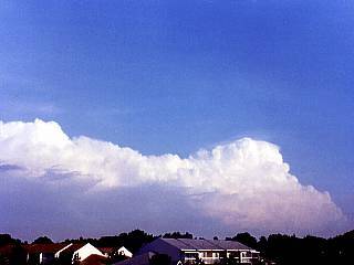
This is a picture of a line of thunderstorms moving away from south Florida viewed from behind. This type of thunderstorm system is called a MULTICELL LINE, and is different from the multicell cluster in the way the thunderstorm updrafts are organized. In such linear thunderstorm systems, each cell is in a very narrow line, which may be tens (or even hundreds) of miles long. In this picture, the southern portion of the thunderstorm line can be seen. Note the southern most cell just north of the break in the storm line to the right of the picture. This is the "tail end charley" type storm and often is the strongest cell in the line. Development occurs at the leading edge of the storm line and each cell moves with the storm motion vector (such as to the NE), while the entire line moves to the right of it (such as to the SE). |
|
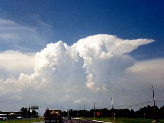
This is a picture of a developing SUPERCELL thunderstorm in south Florida. The main feature here is that we see only ONE main updraft (not overshooting top, and only one). Like the single cell thunderstorm, the supercell updraft is much stronger and contains persistant rotation on a broad scale called a MESOCYCLONE. This storm was producing golf ball sized hail and showed rotation on doppler (MIA WSR-88D) for nearly 30 minutes. Supercell storms often move to the right of the storm motion vector (winds blow anvil to NE, but storm moves to SE or even S). In this picture, the storm is moving SSE but the mean winds are blowing everything else to the NE (view is to the E). |
Supercells - A "supercell" thunderstorm is a highly organized thunderstorm containing a powerful single updraft accompanied by persistant rotation. Actually, supercells have the same single updraft characteristic as their distant "single cell" thunderstorm cousins, however, the speeds of this single updraft are incredibly fast, as much as 175 MPH. In addition to the high draft speeds, a broad rotation persisting for at least two WSR-88D doppler radar scans (about 15 minutes) called a mesocyclone, is used to classify a true supercell. Supercell thunderstorms come in all shapes and sizes and ALL are capeable of producing some sort of severe weather including very high winds, large to giant hail, and possibly tornadoes. Supercells can also cause extreme rainfall and flooding. In aviation, supercells also should be avoided by all means to prevent extreme turbulence and damage / destruction to the penetrating aircraft. Generally, supercells are classified into three major classes, LP (low precipitation), HP (high precipitation), and classic. An additional category called a "mini" supercell describes a small or low-topped supercell that is rather small but still contains a mesocyclone and strong, persistant updraft.
|
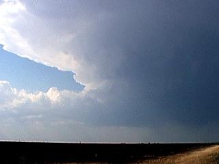
In this picture shows an LP SUPERCELL (low precipitation) over the Texas panhandle. These are full fledged supercell storms with a strong, rotating updraft, but are set apart from other supercells via lack of HEAVY precipitation. In this picture, an inflow tail called a 'flanking line" feeds the storm updraft (center) from the left side of the photo. The anvil is blowing off my stiff NW winds aloft to the right. Whatever "light" precipitation falling out of an LP supercell is often a chunk of large hail here and there (large such as golfball, baseball, etc)! These supercells often develop in high instability and high shear environments plagued by limited moisture, as in this picture, along a dryline. Chasers who study severe weather in western sections Texas, Oklahoma, and Kansas should encounter this type of supercell sooner or later. |
|
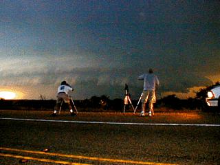
This is a picture of an HP SUPERCELL (high precipitation) in Texas during one of my chase expeditions. Like all supercells, there must be a single and rotating updraft. In this picture, the mesocyclone is clearly apparent by the striated cloud structure of the supercell updraft. The main characteristic of an HP supercell is that precipitation often falls through the mesocyclone and updraft. Here we see dark precipitation under the rotating updraft, and brighter greenish / orange shades to the far lower-right which is the main hail shaft of the storm. The center of the rotation at low levels is just to the right of the center of the photo (near the tripod and man standing to the right). These type of supercells require abundant moisture, high instability, and moderate to strong wind shear (especially directional shear). |
|
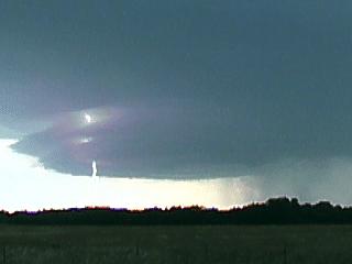
This is a picture of a CLASSIC supercell over Texas with a CG (cloud to ground) lightning strike. Like all supercells, the round "platter" like appearance of the rain free base indicates presence of a mesocyclone. With a classic supercell, the rain and precipitation core is away from the updraft, in this picture, to the right. Little or no precipitation falls through the updraft and mesocyclone. The CLASSIC variant name was coined by scientists as a "text-book" type storm with a rather intuitive layout for the updraft base and separate but heavy precipitation core down wind from the updraft. These supercells develop in high shear and high instability environments with moderate (or high) available moisture. |
|
This is a picture of probably the least known types of supercells, the miniature or MINI SUPERCELL. This type is smaller than an LP (low precipitation) type storm ans is often called a "mini meso" or "zero-P" storm. Despite its small size, it still contains a strong and persistantly rotating updraft, like any other supercell class. In the picture here, we see an elevated (base about 10,000 feet AGL) and rather low topped (top near 30,000 feet) miniature supercell over western Texas. Also notable in this picture is an inflow tail (center of picture), and slight "twisting" of the cell's updraft. The dark precipitation to the lower left is mostly comprised of marble-sized hail. These storm develop in regions of high instability and shear, but with very limited moisture, similar to LP supercells and are common along drylines. |
HTML File "schcloud.htm" - Developed By Chris Collura
To Return To The HOME Page Of This Site Click The "INDEX.HTM" Link Here!