QUINTER KS - MAY 23, 2008
FRIDAY, MAY 23, 2008
KANSAS - CENTRAL USA
A TORNADO CHASER'S STORY
BY CHRIS COLLURA
QUINTER KS - MAY 23, 2008
FRIDAY, MAY 23, 2008
KANSAS - CENTRAL USA
A TORNADO CHASER'S STORY
BY CHRIS COLLURA
MAY 23, 2008 - MAY GLOOM - PART 1
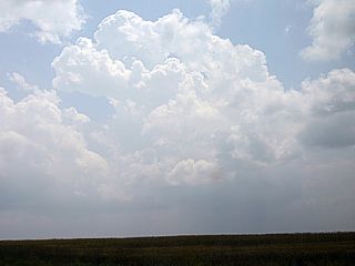
Early on the morning of May 23, 2008, storm chasers Chris Collura and Doug Kiesling awoke to a dull grey and foggy sky at the motel in Hays, Kansas after one of the busiest chase days a day earlier (seeing 5 tornadoes), and still exhausted but energized by the prospect of that day being a repeat (if not worse) than the day before. There was no rush, the storms expected were to be right close to, and just west of Hays, so Chris and Doug took their time packing the vehicles and waited for a third "newbie" chaser, Brandon Clark, to join them for breakfast at Arby's. To an un-trained person, there would be no hint of anything violent that was to occur later that day. The weather was cool and damp, foggy, and gloomy. Chris and Doug, being experienced storm chasers, knew this meant BAD weather, and GOOD chasing. Early in the day, these cool and moist temperatures and low clouds are a sign of excessive moisture feeding into the area from the Gulf of Mexico, about a thousand miles away. The moisture feeds into a developing low pressure system, over southeastern Colorado, as a strong and cold upper-level system moves in from the Pacific.
Chris and Doug met up with Brandon, who was barely awake and beat from the chase day earlier, and they all joked "I'm thinking Arby's"! After breakfast, it was time to fuel up the vehicles and contemplate on where to go. By mid morning, still under fog and low clouds, the forecasting by Chris and Doug painted a violent weather scenario. The moisture was in place at the surface, with dew points in the upper 60's and the temperature nearly the same. Meanwhile, above the low and gloomy stratus over Hays, a stiff south and southeast flow blew hard and strong at 60 to 70 Knots. Called a low-level jet, this wind about a half-mile up is responding to the deepening low over Colorado. Still higher, at about 2 miles up, the wind shifts to the southwest, and is dry and strong at 50 Knots. Both of these characters are very important, as the change in direction produces wind shear (for rotating storms called supercells), and dry air aloft allows storms to develop late in the day, when the sun has baked the ground all day. Still higher, from 4 miles and farther up, a stiff and cold wind honked from the west and southwest at 120 Knots - The jet stream. Chris and Doug thought, "So what do we need?" ... Chris jokingly replies, "Just a little water and heat it up."
Another challenge was presented to the chase group ... You have everything in place but WHERE will the tornado(s) strike? A target area was "forecasted" by Chris and Doug, and a general area was chosen in west-central Kansas from about Ness City / Dighton to just north of Interstate 70. With the daytime heating, the low clouds such as the ones that were over Hays in the morning, burn off and a phenomenon called mixing occurs. This brings the strong winds aloft down to the surface and mixes the moisture in a layer about a half-mile deep or so. Now with no clouds to block the sun, heating occurs, making the atmosphere extremely unstable, however storms do not develop because of the dry layer one or two miles up that storm chasers call a "cap". With the developing Colorado low, a dryline forms as well, where dry down-slope southwest winds meet the warm and moist southeast winds. The combination of the "forcing" from the dryline and upper level low pressure moving in aloft finally overcomes the "cap", and explosive thunderstorm development ensues. Finding these "features" is essential to a successful chase.
- 1 -
MAY 23, 2008 - CONFLICTING BOUNDARIES - PART 2
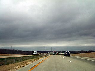
Chris, Doug, and Brandon left Hays for their primary target near Ness City, about 50 miles to the southwest of Hays. They found this strange as this was nearly the exact same spot they began their tornado-filled chase day one day earlier on May 22. They stopped and nudged a bit farther west, to near Utica, while seeing the agitated cumulus bubble over head and race to the north with the low-level jet. Looking at surface observations, a dryline was becoming evident to the west, pretty much stretching from near Colby (along Interstate 70 to the northwest) and bowing southwestward into the extreme corner of southwest Kansas. Meanwhile, a stationary frontal boundary was draped right over Interstate 70, extending in an east to west fashion. By early afternoon, the temperatures increased into the mid 80's, with a hot and humid dew point in the upper 60's, very high for this part of the country. Surface winds continued briskly from the southeast, under partly cloudy skies. Looking up at the clouds, you can visually see one layer moving almost 90 degrees opposite to the other, denoting intense directional shear, where winds change direction with height, a basic requirement for tornadoes.
Upon more review of what was unfolding meteorologically around them, Chris and Doug continued to keep tabs on surface and, most importantly, upper-level data. The dryline boundary, with its hallmark moisture gradient, was clearly visible on surface data and even visible satellite, where you can see the low clouds "stop" where the dryline is. dew points behind this boundary dropped into the 30's, with a hot and dry southwest wind, and temperatures in the 90's. Meanwhile, the frontal boundary near Interstate 70 had its own "changes" along its breadth. Winds were southeast south of it and northeast north of it, with a temperature drop from the mid 80's to the mid 70's, respectively. With the developing low in southeast Colorado, try to imagine the dryline swinging out into the moist air, forming a "sector" between it and the boundary near Interstate 70, with the dryline near there running from the north-northwest to the south-southeast and the stationary boundary near Interstate 70 oriented east to west. This "pizza slice" shaped sector is the focus of incredible forcing (lift) and vorticity (spin), in an already highly sheared (and highly unstable) environment.
By mid-afternoon, Chris, Doug, and Brandon patiently waited near Utica in the rapid in-and-out sun under the passing cumulus. Looking at the upper-level data, using their mobile internet, the leading edge of a strong wave of energy aloft was swinging in overhead. This introduces a strong and divergent jet-stream flow aloft, in excess of 100 Knots, along with very cold temperatures at high altitudes (above 18,000 feet). The dry layer aloft, called the "cap", began to erode as the rising air aloft from the Pacific disturbance crosses from the Rockies and overspreads the central US Plains. This leaves the previously stable lower atmosphere completely exposed to the upper air dynamics, and rapid storm development focuses on the "weakest links", such as ahead of the dryline and stationary front where the forcing is maximized. The cap has been breached, and Chris and Doug noted large developments of clouds to their west, called "towers", right where the dryline should be relative to them. This was the start of the "big show" and a "big day". The development was confirmed as little "blips" on the weather radar, nicely marking the dryline and boundary interactions as expected. The chase was on ... Drive out there and check it out!
- 2 -
MAY 23, 2008 - HIGH RISK / NO RETURN - PART 3
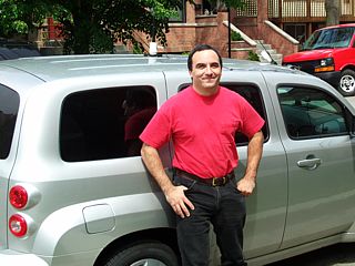
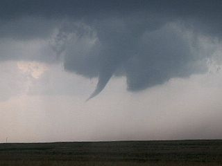
As the afternoon unfolded, and the sun's heat heated the ground under the frigid fast-moving conditions aloft, it became apparent that once storms began, they will quickly become supercellular and start producing tornadoes. The Storm Predictions Center (SPC) had the same area Chris, Doug, and Brandon were in outlooked in a high-risk, and a tornado watch box with the strong-wording "Particularly Dangerous Situation" in place, stressing the high probability of a severe weather outbreak with damaging long-track tornadoes. Chris was driving a Chevy HHR rental, Doug his Jeep Liberty 4x4, and Brandon an older Toyota 4-Runner, and all headed towards the first storm seen firing to their west along the bulge of the dryline boundary. Even from a distance, the first storm exhibited a highly-sheared and explosive look to it, with a wide spreading anvil streaming overhead, hazing out the strong sun. Continuing to the west, now between Utica and south of Dighton, the developing base of the storm became visible, growing darker, then developing a small wall cloud, and having an increasingly circular base. The first supercell of the day was before them, and they were chasing it.
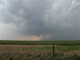
The first supercell storm had a rather tough time getting its act together. A wall cloud, which is a lowered storm updraft base, would develop, rotate a bit, maybe produce a funnel or two, then weaken - Repeating this cycle several times during its 30-Knot journey north. With the supercell storm, now passing Dighton and continuing north, becomes a chaser "beacon", attracting storm chasers from miles around, turning the normally desolate country roads into a rush-hour like traffic jam of storm chasers from every walk of life, from amateurs to scientists, some with the most sophisticated equipment imaginable. The supercell storm grows meaner looking, with a black base and bizarre "knuckled" formations connecting the anvil to the striated updraft tower. Chris and Doug's group is now headed north on Castle Rock road. They try to keep ahead of the storm, watching funnels form on the rotating wall cloud, and knowing that the storm is only just getting started as it is only about 4 PM. They attempt to take a short-cut, only to find the road turning to dirt, then weaving through hilly terrain, and nearly disappearing. A course adjustment / back-track gets them back on track, after nearly losing sight of the supercell altogether.
What was causing the supercell storm to not produce a tornado initially was that it was not in the right position along the dryline. Eventually, this storm would continue north and reach the vicinity of Interstate 70 and interact with the additional shear and forcing associated with the stationary front and dryline intersection, where the true violence of the supercell would be displayed. This storm was the first of several supercells to do this. About 10 miles south of Interstate 70, back on Castle Rock Road and headed north, Doug stops to say hello to a few chasers, including Jim Reed. Brandon, focused on the intensifying storm to the northwest, slides into a ditch on the muddy road. Brandon tried desperately to get out of the swale, at no avail, until Doug hooked a tow rope and winched him out with his Jeep. All the while, giant hail stones, up to baseball sized (from when the storm passed there a few minutes before), dotted the landscape. Chris and Doug were relieved to get Brandon back on the road, and able to continue north keeping the storm in their sight.
- 3 -
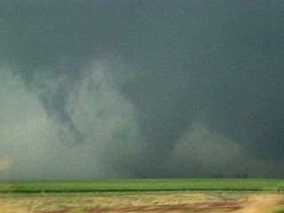
MAY 23, 2008 - IN THE BEAR'S CAGE - PART 4
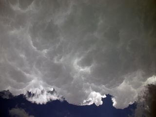
Darkness began to fall on Castle Rock Road and the chase group just south of Quinter, Kansas as they approached Interstate 70. The supercell storm literally expanded five-fold in size with a bluish-green to nearly black base to the northwest of the chasers. With isolated baseball sized hail dotting the road, Chris, Doug, and Brandon cautiously continued north into the near-night and lightning-shot darkness, staring northwest and searching for any details. Upon coming past a row of trees and a few gain elevators, the distinct silhouette of a large tornado with debris whirling around it came into view. The shades of darkness and low-light conditions made the tornado appear as "dark grey" on "darker grey", but at least the chasers now had an "area" of the storm to focus on. Overhead, the curve of the storms intense mesocyclone whirled overhead, and the large tornado to the west quickly disappeared as the supercell "cycled" again. Looking north from this vantage point, the stationary frontal boundary became visible as a low line of roiling clouds. The dew point in this area shot up from the upper 60's to the low 70's because of the moisture convergence.
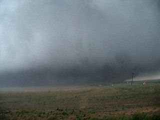
Continuing north on Castle Rock Road, the intersection of Interstate 70 was crossed, and the chase group, along with many other chasers, was in the small farming town of Quinter, Kansas. Looking west, another brief tornado spun up right over the Interstate, and a small funnel danced around its southeastern side. The animated sky took on a dark and nightmarish green-black hue with the afternoon environment turned so dark it was like driving at night. The Discovery Channel group was among the chasers on the north side of Quinter, along with the famous "Tornado Intercept Vehicle" (TIV), driven by Sean Casey attempting to document the tornado from the Interstate, and the Doppler on Wheels (DOW) truck scanning the storm. All the while, tornado warning sirens blared throughout Quinter. The supercell storm continued to the north, and finally "anchored itself" on the stationary frontal boundary. This mere interaction allows the enhanced horizontal vorticity (from the southeast winds hitting and over running the northeast winds) to "supercharge" the rotation in the supercell storm.
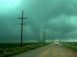
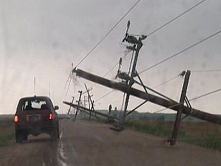
Continuing northward, and thankfully clear of Quinter and back in open farmland, the true violence of the supercell became apparent. The entire gigantic storm, from end to end, was quickly rotating, almost like being under a giant "wheel" in the sky. Doug was leading the way, followed by Chris and Brandon. In between their group were members from scientist Tim Samarass' TWISTEX chase team, with two mobile mesonet vehicles bristling with instrumentation. Out of the whirling mass overhead, a funnel descended, kicking up a debris cloud. This tornado quickly grew large, becoming a full-fledged stove-pipe tornado, surrealistically illuminated by the dark-black / greenish colors. Continuing north, with the large tornado moving north, gigantic hail - Larger than grapefruit sized - Could be seen shattered in the dirt road as bright sparks lit up ahead as the tornado took out power lines. Chris, knowing a much about supercell evolution, sees the stove-pipe tornado moved northeast, then curve back northwest. Realizing this may be a "satellite" tornado (rotating around a larger one), he gazes to the northwest to see a mile-wide wedge tornado, with the "satellite" tornado eventually disappearing out of sight behind it!
- 4 -
MAY 23, 2008 - NEAR DEATH - PART 5
Focusing on the view presented before him in his windshield, Chris decides he is getting too close for comfort. A wedge tornado is a tornado that appears wider than it is tall, and accounts for most violent tornado accounts. Chris pulls off Castle Rock Road and parks in front and upwind of a small power substation with Brandon close behind. Doug continued north, and the two other vehicles from Tim's group also pull off in between them. Within seconds, and with the wedge tornado about a half a mile to their north and passing by, the storms violent and powerful read-flank downdraft (RFD) strikes. Chris tries to point his vehicle so that it is facing into the increasing wind, with his drivers-side window still open from filming. The winds increase with a screaming and howling sound, then a loud roar. Chris ducks and braces for the worst, and the power poles on each side of the substation fall and send a shower of sparks everywhere. The rear drivers-side window blows out sending glass throughout his vehicle with a loud bang. The other two vehicles from Tim's group are blown off the road and into a ditch, with one of them losing their top-side equipment forever.
The loud howling and screaming of the wind temporarily subsides, with the view out the other side of Chris's vehicle being nothing more than a wall of clouds and debris, racing from left to right, from the mile-wide tornado less than a half mile to the north. Another blast of rear-flank winds strikes, and the ear-splitting howling and roaring again picks up, blowing rocks and sand into the shattered window of Chris's vehicle. Once this second blast subsides, Chris and Brandon pull up a bit so that their vehicles are out of any power lines and imminent danger. Knowing it's a rare chase opportunity to see a violent tornado so close, they both get out and film the meteorological drama a short distance to their north. The wedge tornado is so large it appears as a wall of rapidly moving clouds. To film it, even on wide angle, you had to pan to get the whole thing in your view finder. Hay bales and tumbleweeds could be seen blowing across the plowed field separating the wedge tornado and them, but looking more closely, and right NEXT to the wedge are some headlights, rocking in the distance - Doug's vehicle!
Brandon, being on his first chase and tagging along with Chris and Doug from the day before was like a kid in a candy store. They envied him as they certainly would have loved to have experienced such a chase when they both were his age. Brandon, fresh out of the Army, just turned 22 at the time. Chris was happy that him and Doug could take him and show him the true "essence" of the chase. Doug was even luckier to be alive, and began tracking back away from the tornado, being protected during its closest approach by a "burble" created from a berm along the side of the road. The tornado continued for a while, and then appeared to just lift a bit without becoming narrower. It just widened and slowed down, as the parent supercell crossed the aforementioned frontal boundary into the cooler air, and most of its supporting low-level dynamics were suddenly cut off. Conditions after the tornados passage were sobering and quiet. A large "hole", with blue sky peeking through, remained on the backside of the weakening supercell - Punched out by such a powerful rear-flank downdraft. power lines remained strewn across the road and some vehicles had to be pulled out of the ditch. Lucky to be shaken, but not hurt, Doug decided to take a rest and Brandon and Chris continued back south targeting yet another supercell moving up the dryline.
- 5 -
MAY 23, 2008 - LUCK RUNS OUT - PART 6
With the effects and lessons from Quinter just minutes old ripe in their minds, Chris and Brandon, headed back south to check another supercell coming up the "pike" ahead of the dryline. Brandon used his Army jacket, and duct-tape, to cover the shattered window on Chris's HHR rental. Once again, they headed south along Castle Rock Road, and about 10 to 15 miles south and a bit southwest, the supercell was encountered. The smaller supercell storm dropped quarter sized hail, then moved closer, offering a view of the rain-free base and wall cloud. The storm was higher-based than its former "big brother" earlier in Quinter, but slowly spun up a beautiful funnel extending half-way to the ground. A small contact swirl, barely visible over a small hill in the foreground, awarded them with the feeling that they have yet another tornado to brag about for that day. This small tornado quickly lifted, and the storm moved northeast, passing directly over Chris and Brandon as a rotating wall cloud. They let the supercell move northeast until it got too far to see any details.
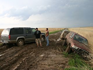
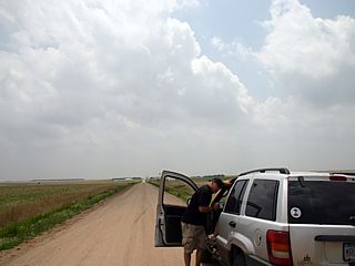
Chris and Brandon realized the storm was moving northward, ahead of and along the dryline, and eventually will be "conveyed" into the same boundary (and dynamics) that supercharged the earlier tornadic storm north of Quinter, so they decided to follow it. With multiple storms training over the same area, the back-road conditions became more and more inhospitable. Attempting to keep up with the supercell proved futile, with the road conditions of the un-paved Kansas farm roads becoming impossible to drive on. The ground in western Kansas is a powdery hard-packed clay and fine sand. When dry, it's nearly like driving on a paved / gravel road. When it gets wet, it takes on the consistency of chocolate fudge cake batter or wet cookie dough! Sure enough, and cresting a hill, Chris, leading the way, plows into a puddle atop a foot or two of the thick Kansas mud. He swerves to a stop like a fly getting caught in fly-paper. Brandon, not far behind, comes to a similar stop right behind Chris's HHR, stuck even worse, despite having a 4x4 and mud tires.
Chris and Brandon got out of their vehicles, wondering what to do and forgetting about the small supercell continuing off to their northeast. Chris's foot sank into the mud up to his knees, and when he pulled his leg out, his shoe stayed in the hole. This mud was nasty stuff. Brandon was able to make some head way out of his rut, and tied a tow line onto Chris's vehicle. He tried and tried, only digging in deeper, eventually winding up listing at a dangerous angle with his tires locked-into the Kansas slime up to his rims as Chris's HHR didn't even budge. They were as stuck as you can be, in the middle of nowhere. Even worse, three more tornadic supercells were moving up the dryline with one passing just west of them and dropping dime sized hail. The plan was to find shelter, and leave the vehicles, and try to find a local farmer or resident there to call for help. Chris and Brandon packed up some minimal equipment, such as their phones and cameras, and began a long foot walk across the fields to a local famers house, about 3 miles from where they were stuck. Any attempts to get a cell-phone signal failed.
- 6 -
MAY 23, 2008 - END OF THE CHASE - PART 7
Upon arriving at a remote farmstead, Chris and Brandon knocked on the front door, as another supercell passed just to the east. This was most likely the storm called "Quinter #2", which produced another wedge tornado in the same town! The storms backside had a violently sheared look, was shot with lightning, and had a knuckled back-sheared, setting sun-lit anvil and updraft that looked impressive even 30 miles away. After a few minutes, a friendly local farmer named Trent came to the door, and he was kind enough to take them back to where they were stuck, in a large Chevy Suburban 4x4. Barely able to get the tow rope from under the vehicles, they hooked up to the Suburban and Trent tried to pull them out. Neither Brandon's or Chris's cars budged on several tries, all that happened was the Suburban would dig itself in. Knowing the dire situation they were in, Trent decided to give up, and called a buddy of his that has a large front-assist tractor. From another farm, about six miles away, and after another hour of dodging dangerous supercells, the tractor arrived with Trent shaking hands with his buddy.
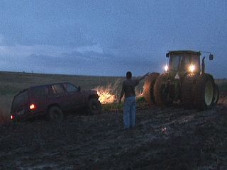
Chris and Brandon were both delighted to see the tractor arrive, but were really concerned about a few things. First of all, the chase day from the point they got stuck was over. They missed the second tornado that rolled through Quinter and yet another tornadic storm taking aim on the town Ellis. Meanwhile, a powerful squall line was developing to the west, and charging east. A more immediate concern was the possibility of even the tractor not being able to pull them out, or even worse, hooking up and pulling an axel off or something. While racing to beat the crush of more severe weather moving in, Brandon hooked up and he was pulled out without any problems. Next up was Chris, who also made it out with no damage and happy to be back on solid ground. Once towed out and happy to be "un-stuck", Chris was so grateful knowing that had this been a recovery from the car rental agency, it would mean being placed on a do-not-rent list and / or paying a thousand dollars, or more, in recovery fees. Trent and his younger farmer buddy with the tractor nodded and told them to "take it easy and be careful". Chris, in his "City Slicker" ways, whips out $100 in cash and presents it to the friendly local. He did not want to accept it until Chris literally shoved it in his pocket.
Chris and Brandon continued to the road they came down from Quinter on and headed north back to Interstate 70 in torrential rains, 60-MPH winds, hail, and lightning as the squall line passed through. They drove past many overturned semi trucks along Interstate 70 as they headed past Ellis, which had no power, and finally into Hays. They stopped to assess the condition of their vehicles, and try to clean the caked-on mud while it was still wet the best they could. There were literally grass and plants jammed in the wheels of Chris's HHR rental, causing imbalance and vibration, which he had to use a spoon to try to scoop them and the mud out! At close to midnight, and with a hell of a story to tell, Chris and Brandon met up with nearly a hundred other storm chasers, including Doug, eating at the Applebees Restaurant in town. What a wonderful experience it was for Chris and Brandon and join all the others, still high on adrenaline, and enjoy a hot and juicy steak dinner and margarita to wash it down.
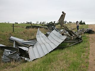
This was just one chase day depicting just about anything that can happen while you are chasing in the Central United States in the area known as "Tornado Alley". Luckily, May 23, 2009 was not the last day of their chase trip, and Chris and Brandon were able to continue chasing through May 30, with some more violent activity, such as getting pummeled with hail, and Chris destroying his Chevy HHR rental on May 26 and requiring a vehicle exchange in Oklahoma City. A damage survey was also done on the area north of Quinter as well earlier on May 26 revealing the true extend of the damage from May 23. The video footage and data collected from Quinter on May 23 also became valuable scientific evidence and had its worth. May 29 was one of the final chase days where at least several tornadoes were observed in Nebraska and Kansas. Nothing like the close-encounter with the "hand of God" could leave such an impression and earned respect from Chris, Doug, and Brandon for years to come.
- 7 -
HTML File "quinter_story.htm" - Developed By Chris Collura
To Return To The HOME Page Of This Site Click The "INDEX.HTM" Link Here!