
| This section is for storm chases done in the central / Midwestern United States during the year of 2022. This includes all storm chasing activities (including any major chase "expeditions") during the year of 2022 in the central USA (aka "Tornado Alley"). For 2022, all chases in the central USA will be logged in this section, with many of the chases being possible "spot" chases / major severe weather "setups" chased. Here you should find many pictures of lightning, tornadoes, hail, strong winds, along with many severe thunderstorm elements. Keep in mind that this chase log is scientific evidence and portrays my on-going storm chasing research. It has been placed on this page for easy reference and meteorological interests. Please do not plagiarize or copy this document to other sites for distribution. Note - This page may take a while to load on some SLOWER connections! |
STORM CHASING - CENTRAL UNITED STATES - 2022 CHASE LOG
| CHASER NAME | HOME / BASE CITY | CALLSIGN | CHASE DATES | OCCUPATION |
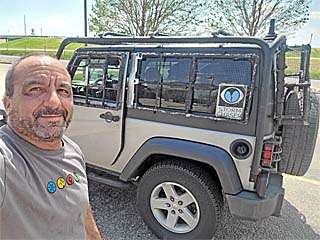
| CHRIS COLLURA | DEERFIELD BEACH, FL | KG4PJN | 4/27 TO 6/18 | IT CONSULTANT |
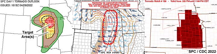
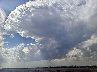
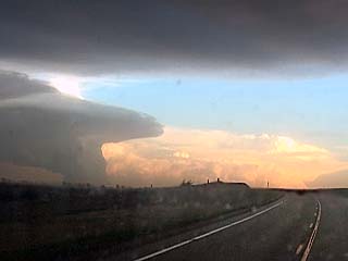
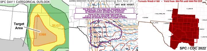
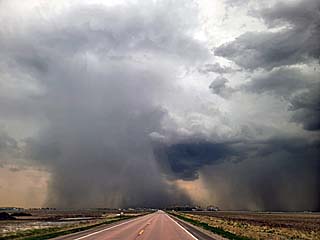
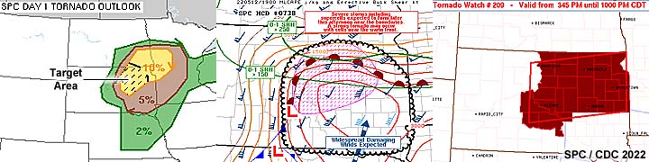
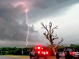
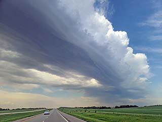
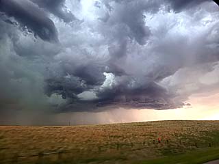
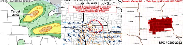
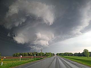
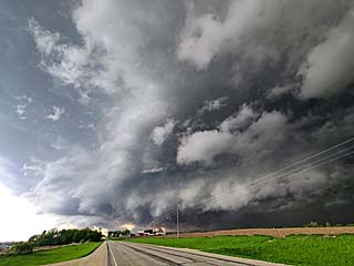
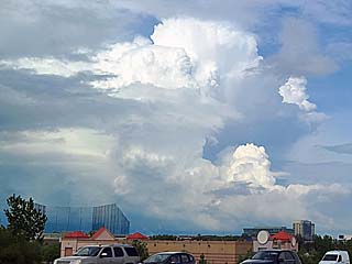
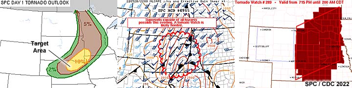
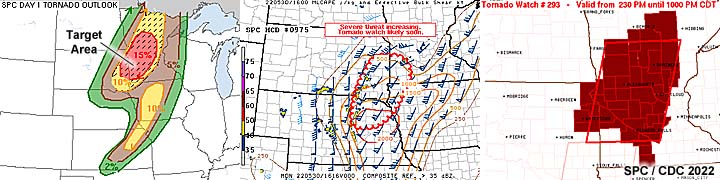
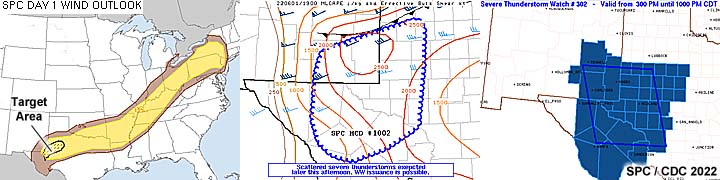
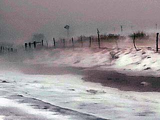
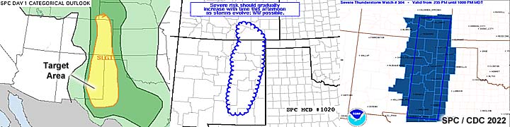
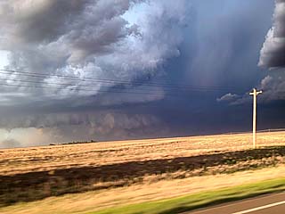
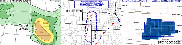
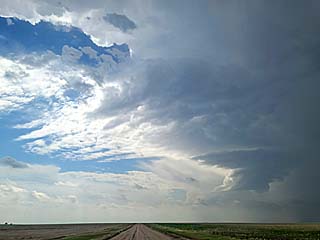
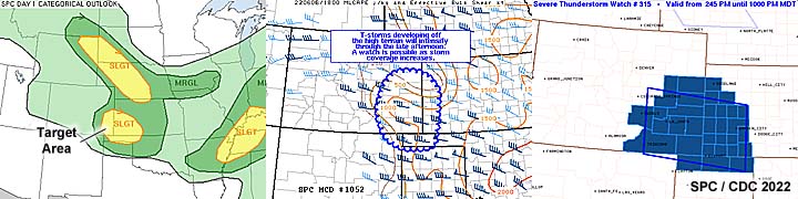
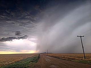
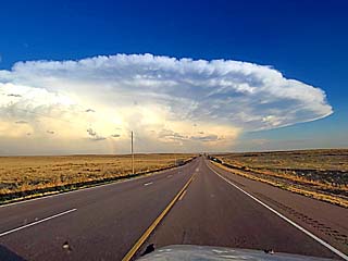
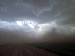
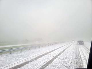
1). Apr 29, 6:30 PM - Interception and observation of an extremely severe and tornadic thunderstorm west of Nevarre, Kansas and west of Highway 77 and northward until Junction City and I-70 from Morrison and to Dickinson Counties. The storm was a powerful classic to HP supercell storm. The storm had a striking visual appearance, with striated "stacked plates" appearance, wall cloud, and funnel / small tornado under the base looking west from near Nevarre and well south of Chapman. The core of this storm was not directly penetrated, and contained hail to grapefruit sized. Conditions encountered were inflow winds over 60 MPH (with blowing dust), hail to 1", heavy rains, and frequent lightning with some close hits. Conditions causing the storm were surface heating, a low pressure system, outflow / stationary boundary, dryline, and an upper trough. A 2016 Jeep Wrangler was used to chase the storms. Documentation was digital stills and HD video. A tornado watch was also in effect for the area valid until 10 PM CDT.
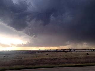
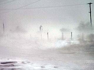
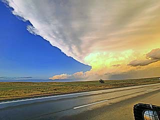
2). Apr 29, 7:30 PM - Interception and penetration of very severe and tornadic thunderstorms near and along Highway 77 in Morrison County, Kansas. These storms were part of a powerful QLCS with embedded / leading-edge tornadic circulations. Looking southwest from near Woodbine, Kansas, a large and persistent landspout tornado was noted looking southwest, with a colorful, multi-tiered shelf cloud / storm structure above it. The tornadic storm near Andover was also visible looking SE from this area at the time at long-range. A close-range / near direct-hit from a powerful leading edge tornado was encountered off Highway 77 near Herington. A third gustnado / landspout as also observed again looking SSE south of Herington. Conditions encountered were maximum winds probably near or exceeding 100 MPH (during close range tornado encounter / inflow jets). Hail to 1", very heavy rains, and frequent lightning was also encountered with penetration of this storm line. Conditions causing the storm were surface heating, a cold front / dryline, and an upper trough. A 2016 Jeep Wrangler was used to chase the storms. Documentation was digital stills and HD video. A tornado watch was also in effect for the area valid until 10 PM CDT.
3). May 1, 6:00 PM - Interception and direct penetration of an extremely severe thunderstorm from south of Seminole, Texas along Highway 385, and points east from Gaines / Andrews Counties across Martin, Dawson, and Borden Counties to near Highway 87 past Patricia. The storm was a classic supercell storm, developing within a wide area of scattered supercells. Part of the core of the storm was penetrated, and conditions encountered were extremely large hail (up to baseball sized), heavy rains, 60 MPH winds, and frequent lightning. The storm remained mainly over open country, so no damage was observed, except for a large fire cause by lightning north of Andrews east of Highway 385. The hail also cracked the windshield of the chase vehicle. Conditions causing the storm were surface heating, a up-slope wind flow, a dryline, low pressure trough, and an upper trough. A 2016 Jeep Wrangler was used to chase the storms. Documentation was digital stills, audio, and HD video. A tornado watch was also in effect for the area valid until 10 PM CDT.
4). May 2, 3:30 PM - Interception and indirect penetration of a very severe thunderstorm in Major County, Oklahoma, near Fairview and Highway 60 / SR 58. The storm was a supercell storm, that evolved to HP and quickly became undercut from the advancing cold front. Conditions encountered were heavy rains, hail to 1", 60 MPH winds, and occasional lightning. The main core had hail to 2". A brief funnel was also noted with this storm. Conditions causing the storm were surface heating, a Pacific cold front / warm front, low pressure area, and an upper trough. A 2016 Jeep Wrangler was used to chase the storms. Documentation was digital stills, audio, and HD video. A tornado watch was also in effect for the area valid until 10 PM CDT.
5). May 2, 4:30 PM - Interception and observation of a very severe and tornadic thunderstorm in Kingfisher County, Oklahoma, near Dover / Lacey and near SR 51. The storm was a classic supercell storm, that eventually evolved to HP and merged with convection associated with the advancing cold front. Two small tornadoes were observed with this storm, one from a distance, and another within a 2 mile range west of Dover. No damage was observed. The storm also had a striking visual appearance. The core was not penetrated. Conditions encountered were light rain, 45 MPH winds, and occasional lightning. Conditions causing the storm were surface heating, a dryline, low pressure area, and an upper trough. A 2016 Jeep Wrangler was used to chase the storms. Documentation was digital stills and HD video. A tornado watch was also in effect for the area valid until 10 PM CDT.
6). May 2, 7:30 PM - Interception and observation of a very severe thunderstorm in Cleveland County, Oklahoma, near Purcell and north of SR 39. The storm was an LP supercell storm, that ultimately merged with convection associated with the advancing cold front by dusk. A rotating wall cloud and funnel was observed with this storm. The storm also had a striking visual appearance. The core was not penetrated. Conditions encountered were light rain, 45 MPH winds (as the storm evolved to an MCS), and frequent lightning. Conditions causing the storm were surface heating, a dryline, and advancing Pacific cold front, and an upper trough. A 2016 Jeep Wrangler was used to chase the storms. Documentation was digital stills and HD video. A tornado watch was also in effect for the area valid until 10 PM CDT.
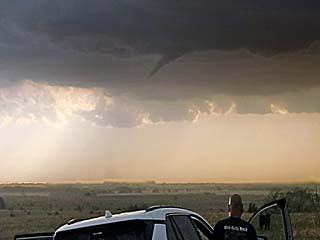
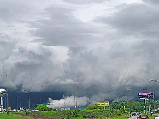
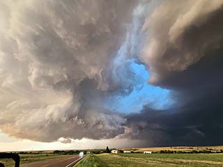
7). May 4, 7:30 PM - Interception, observation, and indirect penetration of an extremely severe and tornadic thunderstorm from southwest of Paducah, Texas in Cottle County, and points east across Foard County SW of Crowell and into Willbarger County south of Vernon and SE of Lockett. Nearby highways were 83, 82, 70, and ultimately 183. The storm was a powerful classic (HP at times) cyclic tornadic supercell. When this storm was first encountered, a northern (left), anticyclonic split was noted NW of Matador, with the main south (right) split near Crosybyton. Up to 5 tornadoes were observed with this storm. One (weak one) looking SW of Paducah from a distance and another passing east of Highway 83 and southeast of Paducah before losing sight of it. The third, and most significant tornado, was encountered along SR 6 and southeast of Crowell. Another rain-wrapped tornado was encountered east of Crowell as the storm became HP. A final, large, possibly a wedge tornado, was observed after dark from east of Lockett, south of Vernon, and west of Highway 183. In addition to the tornadoes, the core of this storm was indirectly penetrated, and had winds of over 65 MPH (esp. RFD), hail to 1”, and frequent lightning. Damage occurred in Lockett, Texas. This storm also had a striking visual appearance at times. Conditions causing the storm were surface heating, a dryline, low pressure area, warm front, and an upper trough. A 2016 Jeep Wrangler was used to chase the storms. Documentation was digital stills and HD video. A tornado watch was also in effect for the area valid until 10 PM CDT.
8). May 11, 3:00 PM - Interception and penetration of a very severe and possibly tornadic thunderstorm in Hutchinson County, South Dakota from west of Highway 81, and along SR 46 and north to Highway 18 near Menno. The storm was a classic to HP supercell storm. A large, rotating wall cloud was initially encountered with this storm, with strong rotation and RFD at one point. Some small funnels were noted, but the storm became outflow dominant before any tornado formed. Other conditions encountered were 60 MPH winds, lightning, very heavy rains, and hail up to golf-ball sized. Conditions causing the storm were surface heating, an MCV / upper trough, low pressure trough, and warm front. A 2016 Jeep Wrangler was used to chase the storms. Documentation was digital stills and HD video. A tornado watch was also in effect for the area valid until 9 PM CDT.
9). May 12, 3:00 PM - Interception of a severe and possibly tornadic thunderstorm in Faulk County, South Dakota near Highway 212 southeast of Faulkton. The storm was a classic to HP supercell storm. A large, rotating wall cloud was initially encountered with this storm, with strong rotation and RFD at one point. A small funnels was also noted, but the storm weakened due to ingestion of cool-pool air from a severe derecho / MCS to the southeast of the region. Other conditions encountered were 60 MPH winds, frequent lightning, heavy rains, and hail up to 1" (quarter) sized. Conditions causing the storm were surface heating, low pressure area, warm front, and upper trough. A 2016 Jeep Wrangler was used to chase the storms. Documentation was digital stills and HD video. A tornado watch was also in effect for the area valid until 10 PM CDT.
10). May 13, 8:30 PM - Interception and indirect penetration of a severe thunderstorm near Anthony, Kansas in Harper County, and near SR 2 and SR 44. The storm was an LP to classic supercell storm, mid-way between a small cluster of supercells. This storm was developing along a stationary front and dryline intersection, and for a while had a rotating wall cloud and small funnel. Large hail was being produced by this storm as well, and isolated pieces of 1" were encountered. The storm had frequent lightning and winds up to 50 MPH were observed with heavy rains, mainly RFD. The storm had a striking visual appearance as well. Conditions causing the storm were surface heating, a low pressure trough, stationary front / dryline intersection, and a departing upper trough (northwest flow aloft). A 2016 Jeep Wrangler was used to chase the storms. Documentation was digital stills and HD time-lapse video. A severe thunderstorm watch was also in effect for the area valid until 1 AM CDT the following day.
11). May 15, 7:00 PM - Interception and penetration of an extremely severe, and potentially tornadic, thunderstorm southeast of Wetumka, Oklahoma in Hughes County, and east of Highway 75 and south of Highway 270. The storm was an intense HP supercell storm. The storm core was penetrated, and hail up to 2" was observed, with 70+ MPH wind gusts, torrential (horizontal) rains, and frequent lightning with numerous close hits. The storm re-organized southeast of Wetumka, where a rotating wall cloud was visible in the supercell "notch" before becoming rain-wrapped. The storm mainly affected rural areas, and tree damage was noted. The storm also had impressive mammatus on its backside. Conditions causing the storm were surface heating, a low pressure trough, stationary front / outflow boundary, and rear entrance-region of an upper trough (with northwest flow aloft). A 2016 Jeep Wrangler was used to chase the storms. Documentation was digital stills and HD / time-lapse video. A severe thunderstorm watch was also in effect for the area valid until 10 PM CDT.
12). May 17, 6:00 PM - Interception and indirect penetration severe thunderstorms in Harlan County, Nebraska and near Highway 136 and west of Franklin. The storm was the north end of a storm cluster, with some high based supercells observed there. Frequent lightning (with some close hits), hail up to 1", 60 MPH winds, and heavy rains were observed with these storms. Conditions causing the storms were surface heating, a low pressure area, stationary front, and an upper trough. A 2016 Jeep Wrangler was used to chase the storms. Documentation was digital stills. A severe thunderstorm watch was also in effect for the area valid until 12 AM CDT the following day.
13). May 19, 7:30 PM - Observation and indirect penetration of a very severe thunderstorm from Mower to Fillmore County, Minnesota from north of Austin near Highway 218 and eastward to near Preston along SR 16. The storm started out as a multicell cluster of strong and severe storms, eventually evolving to an HP supercell, albeit outflow-dominant. A rotating wall cloud was noted on this storm near Preston, and after being under-cut by outflow, produced a small funnel noted to the north of SR 16. The main core of the storm was not penetrated. Other conditions encountered were 60 MPH winds, moderate rain, hail up to 1", and frequent lightning. Conditions causing the storm were surface heating, low pressure area, warm front, and upper trough. A 2016 Jeep Wrangler was used to chase the storms. Documentation was digital stills and HD video. A tornado watch was also in effect for the area valid until 10 PM CDT.
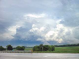
14). May 25, 4:30 PM - Observation of a severe and possibly tornadic thunderstorm from near I-88 / I-355 in Dupage and Cook Counties in Illinois and just west of Chicago. The storm was a classic supercell storm, and observed from about 5 miles away. Rush hour traffic prevented any direct penetrations of the storm. This supercell had a striking visual appearance, with striated updraft, RFD region, and large wall cloud. Some funnel clouds were observed with this storm. The core was not penetrated. Conditions causing the storms were a low pressure trough, warm front / convergence axis, upper low / trough, and surface heating. A 2016 Jeep Wrangler was used to chase the storms. Documentation was digital stills.
15). May 29, 8:30 PM - Interception and indirect penetration of an extremely severe thunderstorm near Taylor, Nebraska in Loup County, and near SR 91 and Highway 183. The storm was a classic supercell storm. The storm core had hail up to 4", but the core was not directly penetrated. Hail to 2" was noted near Highway 183 and SR 96. A rotating wall cloud was also noted with the storm, along with 50 MPH winds, heavy rains, and frequent lightning. The storm (tornado warned) remained over mostly rural areas, and weakened later east of SR 11 and SR 95 and Chambers. Conditions causing the storms were surface heating, a low pressure trough, stationary outflow boundary, and an upper low / trough. A 2016 Jeep Wrangler was used to chase the storms. Documentation was HD video and digital stills. A tornado watch was also in effect until 2 AM CDT the following day.
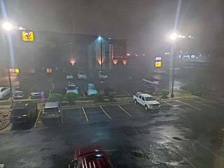
16). May 30, 1:30 AM - Observation (from a stationary area / hotel) of a very severe thunderstorm in Sioux Falls, SD in Minnehaha County near 41 St and I-29. The storm was part of a powerful MCS of severe thunderstorms. The storm was observed while checked into a hotel, and winds gusting near 75 MPH were observed. The storm also had horizontal rains, small hail, and frequent lightning. Wind damage, especially to trees, was also noted with this storm, and some areas lost power. A hotel next to mine suffered major roof damage from this storm. Conditions causing the storms were surface heating, a low pressure trough, stationary outflow boundary, and an upper low / trough. A 2016 Jeep Wrangler was used to chase the storms. Documentation was HD video and digital stills. A tornado watch was also in effect until 2 AM CDT.
17). May 30, 3:00 PM - Interception and observation of a severe thunderstorm near Lake Benton, Minnesota and west of Highways 75 and 135 in Lincoln County. The storm was an embedded developing small supercell storm withing a line / cluster of strong and severe thunderstorms. A small circulation with intense wind gusts was noted on the south side of this fast moving storm. Conditions encountered were 60 MPH winds, heavy rains, small hail, and lightning. Conditions causing the storms were surface heating, a strong low pressure area, warm front, and a strong upper level low. A 2016 Jeep Wrangler was used to chase the storms. Documentation was digital stills. A PDS (particularly dangerous situation) tornado watch was also in effect until 10 PM CDT.
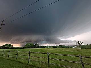
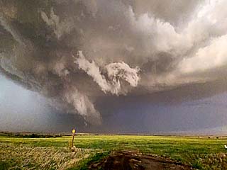
18). May 31, 5:00 PM - Observation and indirect penetration of a very severe and tornadic thunderstorm from northeast of Elk City, Oklahoma ans east towards Clinton and Weatherford, mainly in Custer County and west of Highway 183 and near SR 33. The storm was a classic to HP supercell storm. A large and rotating wall cloud was also noted with funnels and a possible brief tornado north of Arapaho. The storm had a striking visual appearance as well. A strong, multi-vortex type gustnado was also observed over Foss Lake, associated with the leading edge of the RFD of this storm. The core was not directly penetrated, except for punching through 60+ MPH RFD and entering the "bears cage" of the storm, where a large funnel was observed. Other conditions including torrential rains, hail to 1", and frequent lightning with some close hits. Conditions causing the storms were surface heating, a stationary front, and a departing upper trough. A 2016 Jeep Wrangler was used to chase the storms. Documentation was HD video and digital stills. A severe thunderstorm watch was also in effect until 10 PM CDT.
19). June 1, 5:00 PM - Interception and indirect penetration of a very severe, and possibly tornadic thunderstorm west and northwest of Jal, New Mexico and eastward along SR 128, mainly in Lea county. The storm was a powerful classic to HP supercell storm, developing on the south end of a small cluster of splitting supercells. The storm moved southeastward south of Jal and crossed SR 18 as an MCS from the south merged with the storm. An area of strong rotation, with RFD and dust (possible a weak tornado) was noted west of Jal before the storm became outflow dominated. Other conditions observed were 60 MPH winds, heavy rains, hail to 1", and frequent lightning with some close hits. The core was not penetrated, and had hail probably to 4". Conditions causing the storms were surface heating, a slow-moving cold front, up-slope wind flow, and a weak upper trough. A 2016 Jeep Wrangler was used to chase the storms. Documentation was HD video and digital stills. A severe thunderstorm watch was also in effect until 10 PM CDT.
20). June 1, 6:00 PM - Interception and indirect penetration of a very severe thunderstorm southwest of Andrews, Texas in Andrews County and along SR 115 near FM 181. The storm was a classic to HP supercell storm, and was approached from the west and southwest, and developed east and ahead of a cluster of severe thunderstorms to the west near the TX / NM border. The storm was a prolific hail producer, and the hail swath was encountered along SR 115. In some places, hail, up to golf-ball sized, was piled into drifts, and accumulated as deep as 6 inches in places, snarling oil-worker traffic on SR 115 as it was nearly impassible. The storm also produced hail exceeding 2" in the main core, which was not directly penetrated. On the backside of the storm core, winds out of the north exceeding 75 MPH were observed, with hail up to 1", along with heavy rains and lightning. Conditions causing the storms were surface heating, a slow-moving cold front, up-slope wind flow, and a weak upper trough. A 2016 Jeep Wrangler was used to chase the storms. Documentation was HD video and digital stills. A severe thunderstorm watch was also in effect until 10 PM CDT.
21). June 3, 4:00 PM - Interception and indirect penetration of a severe thunderstorm in Eddy County, New Mexico and west of Artesia near Highways 82 and 285. This storm was an LP supercell storm. It was followed from west of Artesia and southeastwards to near Carlsbad. This storm also produced a rotating wall cloud and small funnels. Other conditions encountered were hail to 1", light to moderate rain, frequent lightning, and 50 MPH winds. Conditions causing the storms were surface heating, up-slope wind flow, a weak surface trough, and a weak upper trough. A 2016 Jeep Wrangler was used to chase the storms. Documentation was HD video (mainly time-lapse) and digital stills. A severe thunderstorm watch was also in effect until 10 PM CDT.
22). June 4, 4:00 PM - Observation and indirect penetration of a severe thunderstorm from near Cope, Colorado in Washington / Stratton County and near Highway 36 and SR 59, and southwestwards to west of Burlington. The storm was an LP storm, and was observed from convective initiation through latter weakening and merging with a line segment. This LP supercell had a pretty impressive visual appearance, and RFD clear slot, with a small funnel observed as well. Hail to 3/4" inch was also encountered, with light rain, lightning, and 40 MPH winds. Conditions causing the storms were surface heating, up-slope wind flow, a weak surface trough, and a an upper trough. A 2016 Jeep Wrangler was used to chase the storms. Documentation was HD video (mainly time-lapse) and digital stills. A severe thunderstorm watch was later issued for this area, effective until 1 AM CDT (the next day).
23). June 4, 6:30 PM - Indirect Penetration of the north side of a severe thunderstorm near Kanorado, Kansas along I-70 in Sherman County. The storm was a supercell storm that quickly evolved to an MCS. Conditions encountered were hail to 1" inch, lightning, moderate rain, and 50 MPH winds. This storm also produced a small anticyclonic funnel on its north side. Conditions causing the storms were surface heating, up-slope wind flow, a weak surface trough, and a an upper trough. A 2016 Jeep Wrangler was used to chase the storms. Documentation was digital stills and audio. A severe thunderstorm watch was valid for the area, effective until 1 AM CDT (the next day).
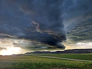
24). June 4, 8:30 PM - Interception, observation, and indirect penetration of a very severe and tornadic thunderstorm north of Oberlin, Kansas in Decatur County, and north of Highway 36 on Highway 83. This storm was a powerful classic to HP supercell storm, and part of a small cluster of supercells. This storm had a striking visual appearance, with explosive development noted on the SW side of the storm, and impressive RFD cut, and strong rotation with an anticyclonic component as well. A brief tornado under rapidly rotating clouds / funnels kicked up dust in a nearby field. The storm also contained hail near 3", but the core was avoided. Other conditions encountered were hail to 1" inch, frequent lightning with close hits, heavy rain, and winds gusting over 75 MPH during the outflow phases of the storm. Conditions causing the storms were surface heating, a stationary frontal boundary, a surface trough, and a an upper trough. A 2016 Jeep Wrangler was used to chase the storms. Documentation was HD video (including time-lapse), audio, and digital stills. A severe thunderstorm watch was valid for the area, effective until 1 AM CDT (the next day).
25). June 5, 5:30 PM - Interception, observation, and indirect penetration of a very severe thunderstorm from Prowers County, Colorado and Highway 50 / SR 89 near Holly, and southward past Walsh in Baca County. The storm was a classic supercell that evolved to LP (low precipitation) mode before down-scaling and dissipating near dusk. This storm had a striking visual appearance, with RFD clear-slot, striations, impressive vault, and wall cloud. 50 to 60 MPH inflow and hail up to 2" was also observed with this storm. The main core was not directly penetrated. On the backside of the storm, 60+ MPH winds were observed in Walsh, mainly outflow and RFD. The storm also produced frequent lightning and heavy rains. Conditions causing the storms were surface heating, a surface trough, stationary outflow boundary, and a an upper trough. A 2016 Jeep Wrangler was used to chase the storms. Documentation was digital stills and HD video. A severe thunderstorm watch was valid for the area, effective until 10 PM CDT (9 PM MDT).
26). June 6, 6:00 PM - Interception penetration of a severe thunderstorm southwest of Lamar, Colorado in Bent County and from Highways 50 and 385. The storm was a high-based classic supercell storm. Conditions encountered were hail to 3/4", lightning, torrential rains, and winds gusting over 70 MPH (an ASOS wind report of 82 MPH was reported southwest if Lamar at this time). Hail was noted covering the ground in Lamar, with flooding and tree debris in the streets. Conditions causing the storms were surface heating, a surface trough, up-slope wind flow, and a an upper trough. A 2016 Jeep Wrangler was used to chase the storms. Documentation was digital stills and HD video. A severe thunderstorm watch was valid for the area, effective until 10 PM MDT (11 PM CDT).
27). June 6, 8:30 PM - Interception and observation of a severe thunderstorm over Sherman County, Texas from a distance and with an indirect penetration of the north part of the storm near Stratford. The storm was a classic to HP supercell storm, and mainly was observed from a distance. When the storm was encountered, some heavy rain, frequent lightning, 50 MPH winds, and small hail was encountered. The main core was not penetrated. This storm also had an excellent and striking visual presentation when viewed from the northwest as it was approached long-range along Highway 287 in the OK panhandle. Conditions causing the storms were surface heating, a surface trough, up-slope wind flow, and a an upper trough. A 2016 Jeep Wrangler was used to chase the storms. Documentation was digital stills and HD video (mainly time-lapse). A severe thunderstorm watch was valid for the area, effective until 11 PM CDT.
28). June 7, 5:00 PM - Interception and indirect penetration of an extremely severe thunderstorm and tornadic thunderstorm near Sedgwick, Colorado in Sedgwick County from near Highway 138 and south to Highway 6 northwest of Holyoke. The storm was a classic supercell storm. A rotating wall cloud and small tornado was also observed over Sedgwick, moving to the southeast, at close-range. The storm also produced tennis ball sized hail, but the core was not directly penetrated. Winds gusting over 60 MPH (mainly RFD), 1" hail, moderate rains, and lightning was observed with this storm as well. The storm also left a hail swath well into Nebraska to near Imperial. Conditions causing the storms were surface heating, a surface trough, a stationary frontal boundary, and an upper trough. A 2016 Jeep Wrangler was used to chase the storms. Documentation was digital stills and HD video. A severe thunderstorm watch was valid for the area, effective until 8 PM MDT.
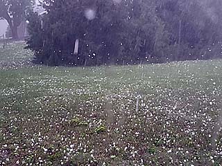
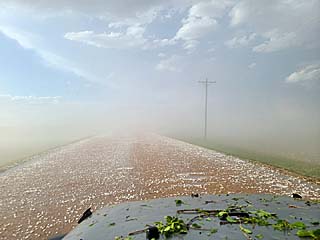
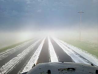
29). June 7, 6:00 PM - Direct penetration of an extremely severe thunderstorm in Chase County, Nebraska south of Lamar and near Highway 6. The storm was a classic to HP supercell storm. Blinding dust with winds up to 70 MPH was observed, along with copious amounts of golf-ball sized hail, with some pieces to baseball sized. The storm also had lightning and very heavy rains. Tree damage was noted from the hail, with leaves and twigs shredded, as well as some trees felled by the strong winds. The hail covered the ground in many places, and hail fog seriously affected visibility. Conditions causing the storms were surface heating, a surface trough, a stationary frontal boundary, and an upper trough. A 2016 Jeep Wrangler was used to chase the storms. Documentation was digital stills and HD video. A severe thunderstorm watch was valid for the area, effective until 8 PM MDT.
30). June 9, 8:00 PM - Interception and indirect penetration of a very severe and possibly tornadic thunderstorm from Lincoln County, Nebraska into Frontier County, along and west of Highway 83 and from near Dickens and SR 23 to northwest of McCook. The storm as an LP to classic supercell storm. A possible brief / weak tornado was observed northeast of Dickens with the wall cloud and RFD during the classic stages of the storm, which was observed from initiation stages. The core was not directly penetrated, but moderate to heavy rain was encountered, along with 60 MPH winds (including RFD), frequent lightning, and hail to 2". The main core had hail exceeding tennis ball sized. This storm also had a striking visual appearance, with "mother-ship" shaped low-level mesocyclone, RFD cut and wall cloud, and striated updraft, especially during its LP stages. Conditions causing the storms were surface heating, a surface trough, a stationary frontal boundary, and an upper trough. A 2016 Jeep Wrangler was used to chase the storms. Documentation was digital stills and HD video (including time-lapse). A severe thunderstorm watch was valid for the area, effective until 12 AM CDT the following day.
31). June 12, 5:30 PM - Interception, indirect penetration, and observation of an extremely severe thunderstorm from north of Gilette, Wyoming in Campbell County from SR 59, then east along I-90 to near Sundance in Crook County and into western South Dakota in Lawrence County. The storm was an HP supercell that evolved to an intense bow / line segment. The storm was followed from initiation about 30 miles northwest of Gilette. This storm produced large, wind-driven hail. The core was not directly penetrated. The storm was mostly outflow dominant, with some wall clouds / funnels observed. Conditions encountered were small hail, 60 MPH winds, moderate rain, and lightning. Conditions causing the storms were surface heating, a weak surface low, a stationary frontal boundary, and an upper trough. A 2016 Jeep Wrangler was used to chase the storms. Documentation was digital stills. A tornado watch was valid for the area, effective until 10 PM MDT.
32). June 12, 6:30 PM - Interception and indirect penetration of a very severe thunderstorm in Lawrence County, South Dakota along I-90 near Sturgis. This storm was an outflow-dominant HP supercell, and was tracked from as far west as Sundance, Wyoming in Crook County. The core was not directly penetrated, but a large hail swath was noted across I-90 near Sturgis, with hail up to golf-ball sized covering the highway a few inches deep. Actual hail falling was up to 1" on the backside of the storm. Other conditions encountered were heavy rain, lightning, and winds near 60 MPH. Conditions causing the storms were surface heating, a weak surface low, a stationary frontal boundary, and an upper trough. A 2016 Jeep Wrangler was used to chase the storms. Documentation was digital stills. A tornado watch was valid for the area, effective until 10 PM MDT.
33). June 13, 7:30 PM - Observation and penetration of a severe thunderstorm in Butte County, South Dakota along Highway 212 between Newell and Maurine. The storm was an outflow dominant HP supercell storm, developing ahead of a cold front. Heavy rains, lightning, small hail, and 60 MPH winds were encountered. Conditions causing the storms were surface heating, a weak surface low, a cold front, and an upper trough. A 2016 Jeep Wrangler was used to chase the storms. Documentation was digital stills and HD video (time-lapse). A severe thunderstorm watch was valid for the area, effective until 11 PM MDT.
34). June 14, 8:00 PM - Interception and observation of a severe thunderstorm south of Adams, Nebraska in Gage County, and near SR 43 and 41. The storm was a small classic supercell storm, that remained mainly over rural areas. It had an impressive, and striated appearance for a while, with small wall cloud, RFD, and small funnel before down-scaling and weakening. A hail roar was also audible with this storm. The core (with hail to 1.5") was not penetrated. The storm also produced heavy rains, 60 MPH winds (not encountered), and frequent lightning. Conditions causing the storms were surface heating, a stalled cold front, and an upper trough. A 2016 Jeep Wrangler was used to chase the storms. Documentation was digital stills and HD video (time-lapse). A severe thunderstorm watch was valid for the area, effective until 4 AM CDT the following day.
35). June 15, 4:00 PM - Observation and indirect penetration of strong and severe thunderstorms from east of La Crosse, Wisconsin along I-90 and south towards Madison, mainly in Monroe County. The storm was a line of severe thunderstorms, with embedded tornadoes on the leading edge (quasi-linear convective system, or QLCS). One strong tornado caused damage from near Tomah, Wisconsin northeastward, near the junction of I-90 and I-94. The interstate was closed in this area, causing a major traffic delay and re-route. Power poles were snapped, and semi-trucks overturned, with tree damage, in a path about 1/4 to 1/2 mile across. The tornado was not observed. Other conditions were frequent lightning, small hail, torrential rains, and 60 MPH winds. Conditions causing the storms were surface heating, a weak surface low, a stationary frontal / outflow boundary, and a strong upper trough. A 2016 Jeep Wrangler was used to chase the storms. Documentation was digital stills. A tornado watch was valid for the area, effective until 10 PM MDT.
36). June 17, 2:30 PM - Penetration of a severe thunderstorm along I-75 near Athens, Tennessee in McMinn County. The storm was part of a cluster of strong and severe storms. Conditions encountered were torrential rains, 60 MPH winds, frequent lightning, and hail up to 3/4". Conditions causing the storms were surface heating, frontal / outflow boundary, and a weak upper trough. A 2016 Jeep Wrangler was used to chase the storms. Documentation was digital stills. A severe thunderstorm watch was valid for the area, effective until 3 PM EDT.
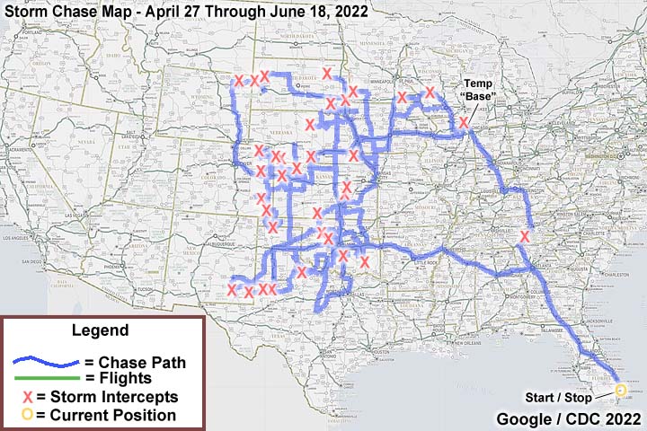
This concludes the chase log for the central US Plains for the main chase "expedition" of 2022 starting on April 27 and ending on June 18, 2022. The summary includes a total of 36 observation(s), out of which there were 36 severe thunderstorms. Out of these thunderstorms, as many as 17 possible tornadoes were observed, most weak or brief, but 2 of which were significant. A 2016 Jeep Wrangler vehicle was used in all of the chases / observations above, logging a total of 20,031 miles. All entries for the logs above are for the local time zone unless otherwise noted. This information was prepared exclusively for the National Weather service and the team of Skywarn storm spotters.
|
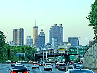
April 27 was departure day, with a long drive from south Florida and into the central USA by April 28. Here is a picture of downtown Atlanta, GA during the afternoon of April 27. |
|
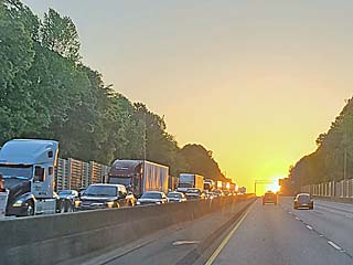
Traffic headed west on I-20 out of Atlanta late in the day around sunset on April 27. |
|
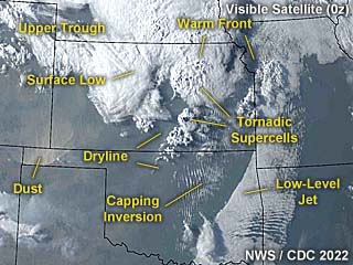
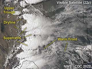
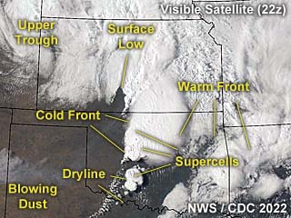
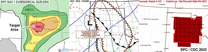
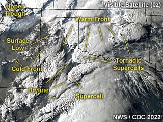
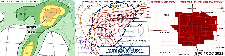
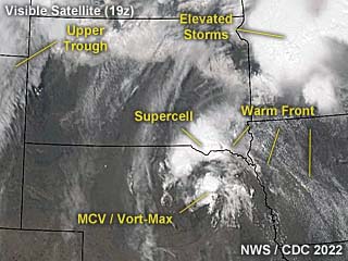
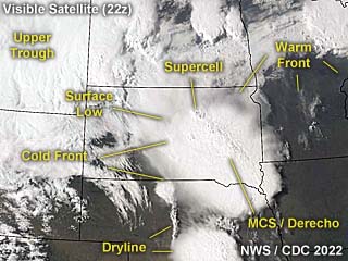
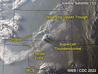
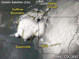
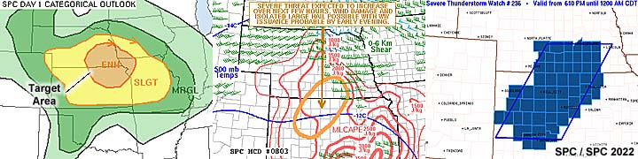
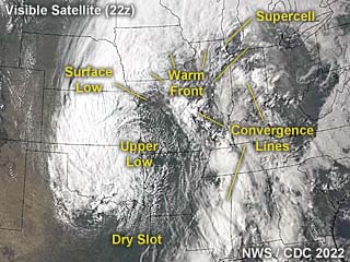
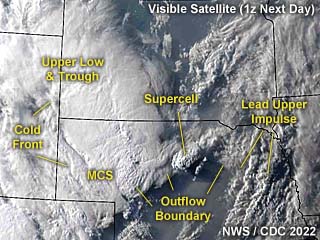
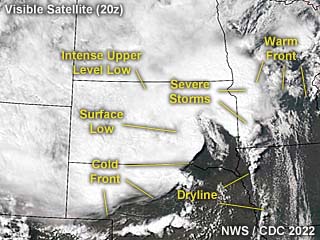
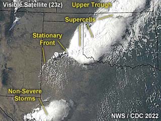
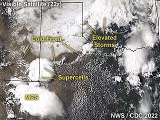
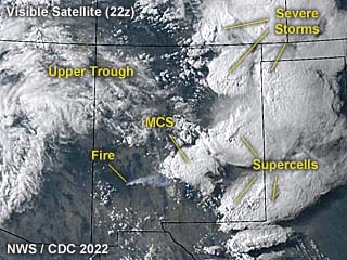
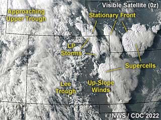
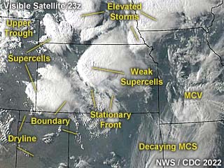
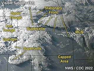
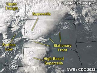
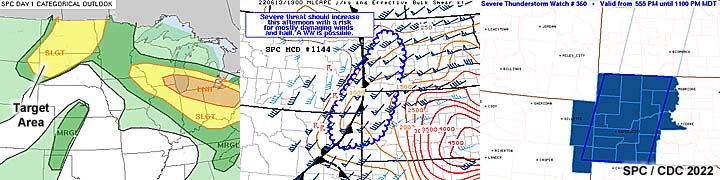
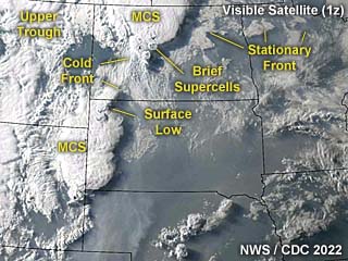
This is an annotated visible satellite image for late in the day of April 29, around 0z. The synoptic setup is shown as well as tornadic storms developing over central Kansas. |
|
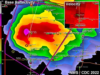
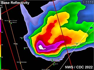
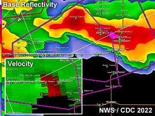
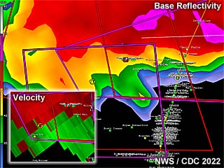
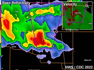
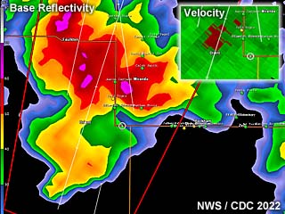
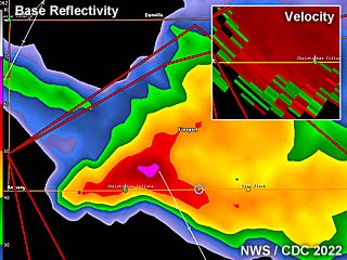
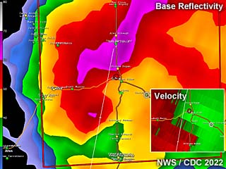
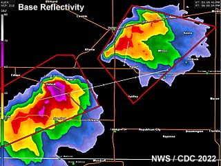
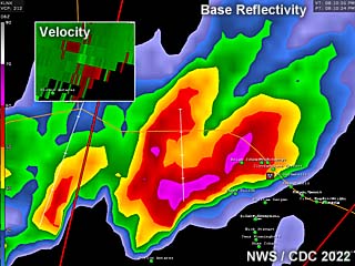
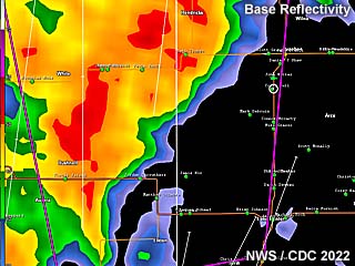
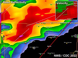
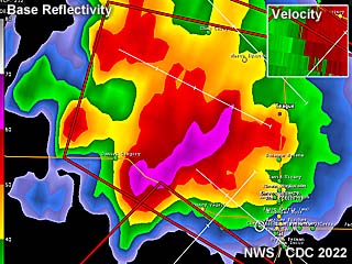
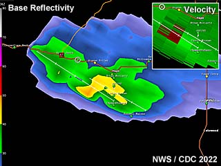
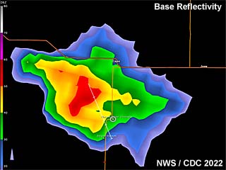
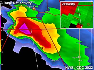
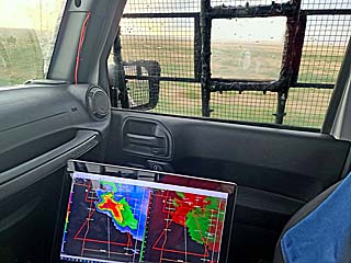
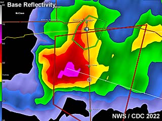
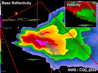
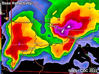
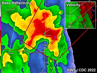
Radar image composite of the first supercell near Marion County, Kansas late in the day (around 6:30 PM CDT). The subtle Doppler velocity is shown in the inset about the time a funnel / small tornado was being produced by the storm south of Chapman, Kansas. |
|
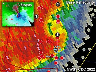
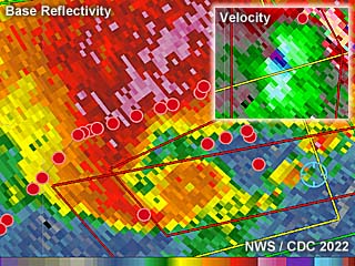
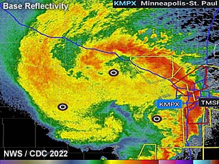
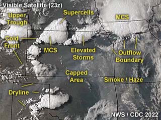
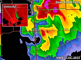
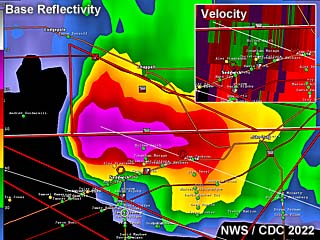
This another radar image composite of an extremely intense QLCS (quasi-linear convective system) tornado north of Marion, Kansas at around dusk (after 8 PM CDT). The reflectivity clearly shows a "swirl" with my position (blue marker) just on the south side of the circulation. The Doppler velocity, inset, shows an intense couplet with this feature. |
|
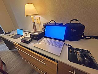
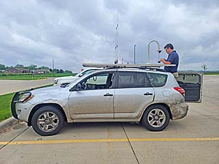
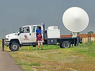
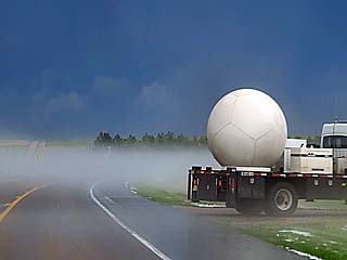
Preparing the chase vehicle, while stopped at Newton, Kansas. Hail grills are in place. |
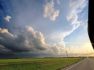
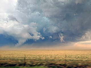
|
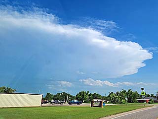
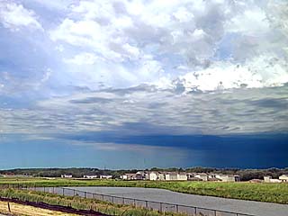
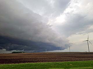
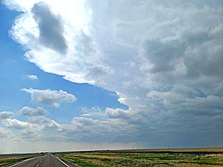
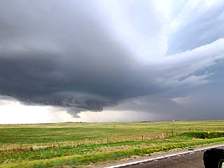
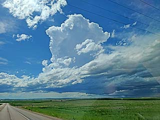
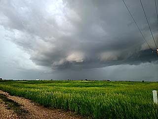
Storm initiation begins in the storm target area looking west from Newton, Kansas. The dryline is sharpening and firing strong and severe storms. |
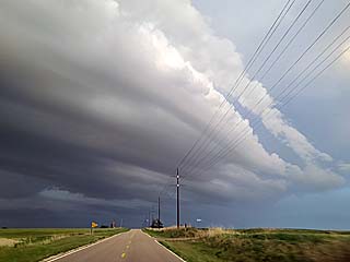
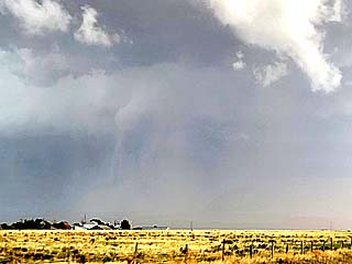
|
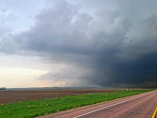
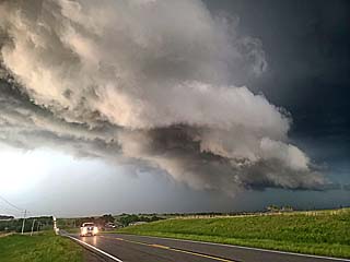
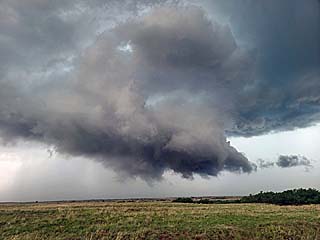
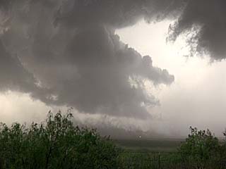
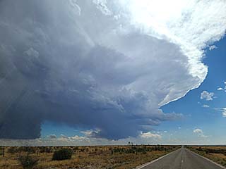
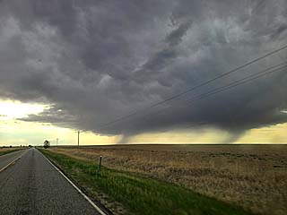
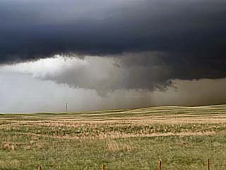
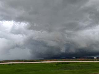
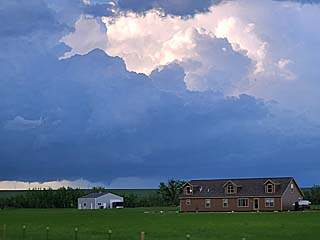
First supercell and wall cloud intensifying over northern Marion County, Kansas west of Nevarre and south of Chapman, Kansas. |
|
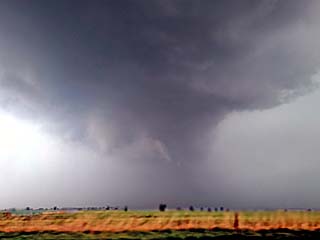
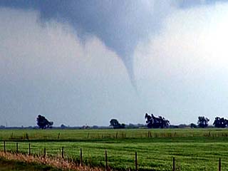
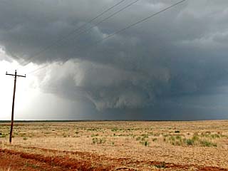
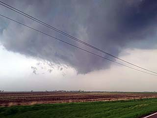
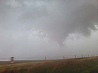
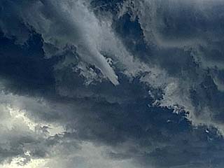
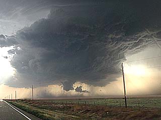
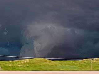
View looking west of a funnel / possible small tornado (note a hint of dust on ground below and to the left of the funnel) associated with the first supercell south of Chapman, Kansas. The view is to the west and southwest. |
|
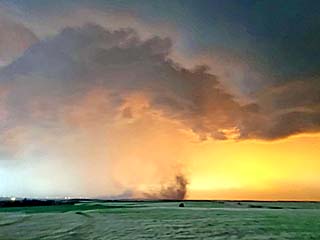
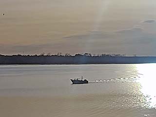
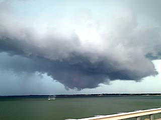
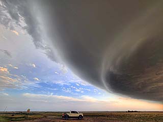
View looking southwest towards a large landspout tornado on the southern end of a large QLCS complex of storms near Marion, Kansas. The view is to the southwest. |
|
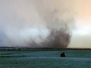
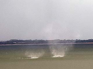
Close up (zoomed) view of the large landspout tornado near Marion County. |
|
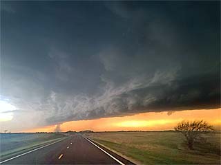
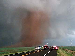
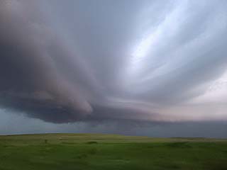
Developing tornado on the leading edge of a QLCS complex of storms. The cloud motion was very rapid and the ground "contact swirl" confirming tornado-genesis. The view is due west, and directly in the storms path west of Highway 77. |
|
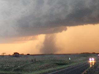
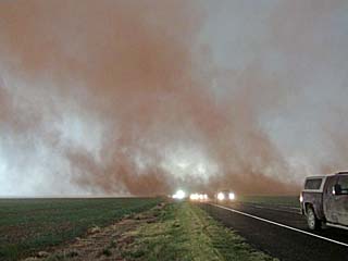
Closer view of ground contact approaching from the west fast. This was a rapidly developing tornado, and observed at close range when attempting to rush south on Highway 77 out of its path. |
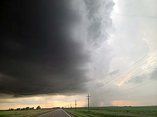
|
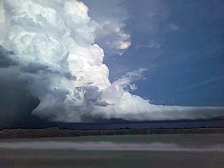
Looking south, two powerful supercells loom over the horizon, one of these was producing a destructive tornado near Andover, Kansas at the time. |
|
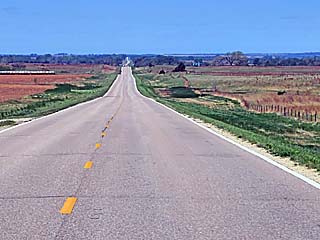
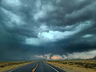
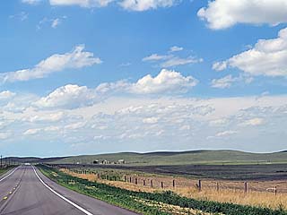
April 30 was a re-position day, with a road trip from Wichita, Kansas to Amarillo, Texas. In this picture, the nearly empty Highway 60 stretches into the distance headed west on a sunny day in the US Great Plains. |
|
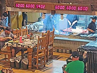
While in Amarillo, I always try to make a stop at the Big Texan steakhouse. Here a man is making an attempt at eating a 72 Oz steak, including sides, in an hour or less (where it's free). He did not make it. |
|
This is an annotated visible satellite image for the late afternoon of May 1, around 22z. The synoptic setup is shown as well as numerous supercell storms storms developing along a large swath western Texas. |
|
Radar image (base reflectivity) of an intense supercell southeast of Seminole, Texas late in the day (around 5:30 PM CDT). This storm was producing baseball sized hail at the time (note the "white" core, and "hail spike" extending to the upper left)! |
|
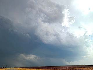
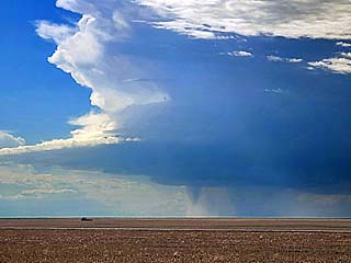
Powerful supercell storm southeast of Seminole, Texas during the afternoon of May 1. Note the "crown" overhead and hail-shaft to the lower right-center. Hail to baseball sized was encountered with this storm. The view is SSE. |

|
Shattered windshield from an isolated impact of baseball sized hail near Seminole, Texas. |
|
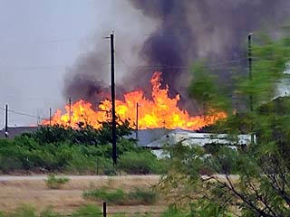
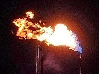
Lightning starts a fire to a dumpsite near Seminole, Texas. |
|
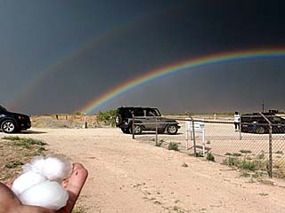
Holding pieces of 2" hail picked off the ground SW of Patricia, Texas with a beautiful multi-rainbow looking to the northeast. |
|
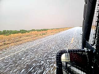
Hail covering the ground near Patricia, Texas. |
|
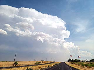
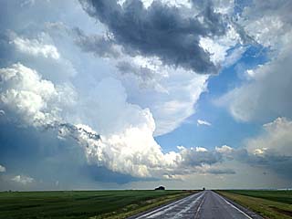
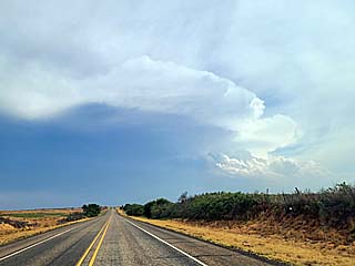
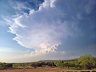
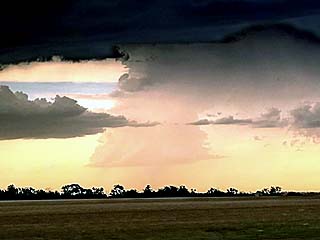
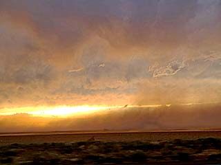
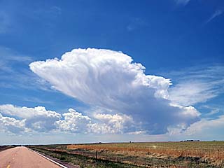
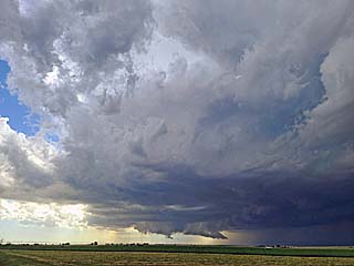
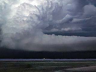
Powerful LP supercell and backsheared anvil looking westward from south of Post, Texas and north of Gail at dusk. |
|
This is an annotated visible satellite image for the afternoon of May 2, around 22z. The synoptic setup is shown as well as some supercell storms, some tornadic, developing along a Pacific cold front and dryline from NW to central Oklahoma. |
|
This a composite radar image of a tornadic supercell near Loyal / Dover, Oklahoma during the afternoon (roughly 4:30 PM CDT). This storm was producing a brief tornado around this time. The base reflectivity shows the shape of the classic supercell in a highly-sheared environment. Doppler velocity is in the inset to the lower-left. |
|
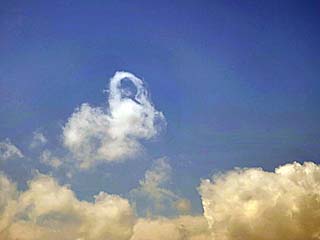
Horseshoe vortex associated with highly-sheared agitated cumulus west of Enid, Oklahoma during the afternoon of May 2. |
|
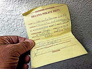
Briefly stopped and given a warning for going 30 MPH in a 25 MPH zone. Always be CAREFUL going through small towns (like Helena, OK)! |
|
Brief funnel associated with a supercell near Fairview, Oklahoma before it was undercut by outflow. The view is to the north. |
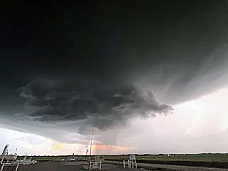
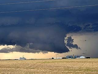
|
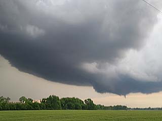
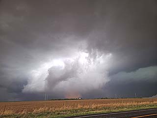
Powerful supercell over Kingfisher County, Oklahoma with rotating wall cloud / funnel. The view is to the SSE. |
|
View of first, brief tornado from a distance over Kingfisher County, Oklahoma. The view is to the southeast. |
|
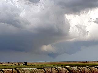
Intensifying tornado, RFD, and impressive supercell structure over Kingfisher County, Oklahoma and west of Dover. |
|
Tornado touches down in an open field west of Dover, Oklahoma. |
|
Updraft base of an LP supercell near Purcell, Oklahoma during the early evening. Note the small funnel on the wall cloud to the lower right. The view is to the Southeast. |
|
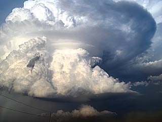
Impressive "mothership" appearance of an LP supercell near Purcell, Oklahoma. The view is to the ENE. |
|
Impressive view of supercell base and highly-sheared updtraft looking northeast from east of Purcell, Oklahoma. |

|
Impressive mammatus at dusk behind the MCS as viewed from north of Purcell, Oklahoma. |
|
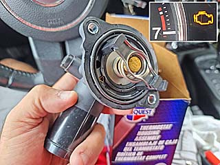
May 3 was the 23rd anniversary of the devastating Moore tornado from May 3, 1999. With much better and cool weather, I was able to work full time at my remote IT job, get some needed food, and also get important repairs done to the chase vehicle. Her I am replacing a bad thermostat on my Jeep Wrangler after getting an engine light for it. More storms are expected tomorrow, May 4. |
|
This is an annotated visible satellite image for the afternoon of May 4, around 0z (early evening). The synoptic setup is shown as well as some supercell storms, including the cyclic tornadic storm near Foard County in Texas developing ahead of a dryline across the E Texas panhandle. |
|
This a composite radar image of the tornadic supercell over Foard County, Texas during evening (roughly 8 PM CDT). This storm was producing a large tornado this time. The base reflectivity shows the classic supercell evolving to HP. Doppler velocity is in the inset to the lower-left. |
|
This a composite radar image of a powerful tornadic supercell near Lockett, Texas during the late evening (around 9 PM CDT) after dusk. This storm was producing a large (probably a wedge) tornado this time. The base reflectivity shows the classic supercell with the violent tornadic circulation (even an "eye" like feature in the debris ball)! Impressive Doppler velocity is in the inset to the upper-right. Not shown, but a TDS (tornado debris signature) was also noted at the time. |
|
Looking south along Highway 70 and south of Turkey, Texas on May 4 during the late afternoon. Explosive supercell development underway near Crosbyton, Texas. |
|
Anticyclonic left (north) split of the supercell storm west of Matador, Texas. The view is to the southwest. |
|
Wall cloud (after brief dust swirls were under it) on the SW side of the right (south) main split of the supercell storm southwest of Paducah, Texas. The view is to the west. |
|
Developing large tornado to the south and southeast of Paducah, Texas. Dust and ground contact can be seen if you look closely under the mesocyclone (center of picture). Note the pronounced RFD clear slot. The view is to the northeast. |
|
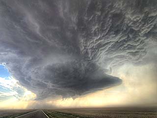
Impressive view of the cyclic supercell from along Highway 62 between Guthrie and Benjamin, Texas as the storm was approaching Crowell. The view is to the north. |
|
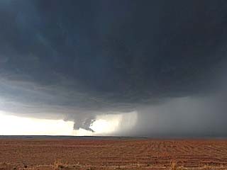
Developing tornado southwest of Crowell, Texas in Foard County. Note the RFD slot and dust on the ground as the storm cycles again. The view is to the WNW. |
|
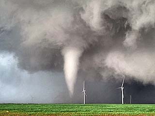
Mature and photogenic cone tornado southwest of Crowell, Texas at around 7:45 CDT. The view is to the west. |
|
Tornado weakens and kicks up dust as it crosses SR 6 south of Crowell, Texas. The view is to the north. |
|
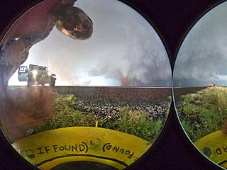
View of attempted deployment of the tornado "probe" 360 camera. The tornado went well north of this area. |
|
Powerful rear-flank downdraft (RFD) winds kicking up dust south of my position on SR 6 as the tornado passes to my north. The view is to the south. |
|
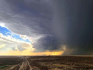
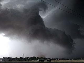
Another tornado develops as the storm becomes HP east of Crowell, Texas as viewed from a farm road. This was inside the "bear's cage" of the rain-wrap of the storm, allowing the large tornado to be observed. The view is to the north. |
|
Large (possibly) wedge tornado after dark (9 PM CDT) near Lockett and Vernon, Texas. The view is to the northwest. |
|
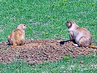
The period from May 5-9 was down time / minimal chasing. Two prairie dogs play in the dirt in Lawton during the evening. This is in a park in Lawton, Oklahoma on May 6. |
|
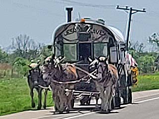
Interesting horse-draw wagon headed north on the east side of Highway 81 in south-central Oklahoma. Sign on the front top says "Jesus Saves". |
|
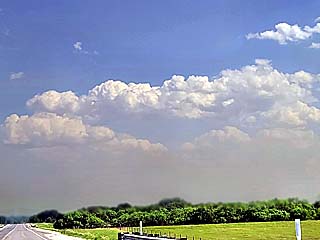
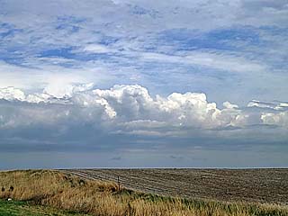
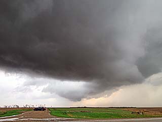
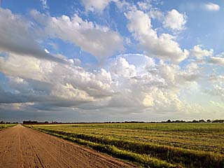
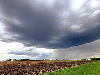
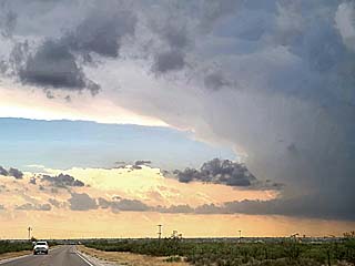
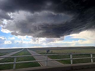
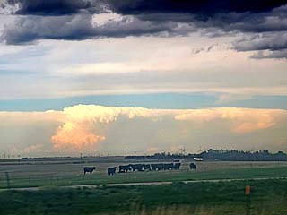
High-based cumulus over Comanche County, Texas ahead of a dryline late in the day on May 7. The atmosphere remained capped and no storms developed despite high humidity under an upper ridge. |
|
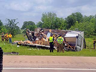
Potentially fatal accident on May 10 northbound on I-35 north of Ardmore, Oklahoma with a long traffic delay. This WAS a large motor-home completely destroyed after hitting a semi-truck. This was not weather related. Today I drove from Plano, Texas to York Nebraska (about a 9.5 hour drive) anticipating more storms on May 11 in the northern Plains / Midwest. |
|
This is an annotated visible satellite image for the afternoon of May 11, around 18z (early afternoon). The synoptic setup is shown as well as a supercell storm developing along the warm front and ahead of a powerful MCV near Hutchinson County, South Dakota. |
|
This a composite radar image of a tornado-warned supercell near Hutchinson County, South Dakota during the early afternoon (around 2:30 PM CDT). The base reflectivity shows small supercell core and developing rotation. Doppler velocity is in the inset to the upper-right. |
|
This is a radar (base reflectivity) of an intense MCV (mesoscale convective vortex) and circulating convection over central Minnesota near dusk. These are meso-scale areas of low-pressure caused by convective activity lowing the air pressure. |
|
Warm frontal zone, with the boundary marked by a line of clouds, looking northeast from Nebraska and south of Yankton, South Dakota on May 11. |
|
Approaching supercell storm (note wall cloud and updraft to right) in Hutchinson County during the early afternoon. The view is to the west. |
|
Rotating wall cloud near Menno, South Dakota. The view is to the northwest. |
|
Clusters of fast-moving strong and severe thunderstorms associated with a mid-level vorticity (MCV) passing overhead. The view is to the east. |
|
This is an annotated visible satellite image for the afternoon of May 12, around 22z (early evening). The synoptic setup is shown as well as a supercell storm developing on the NW tip of a powerful MCS / Derecho pushing across eastern South Dakota. |
|
This is a radar (base reflectivity) image of a supercell storm on the northwestern tip of an "arching" region of destructive winds stretching northwest to southeast across eastern SD at roughly 5 PM CDT. The subtle Doppler velocity is in the inset to the upper-right. |
|
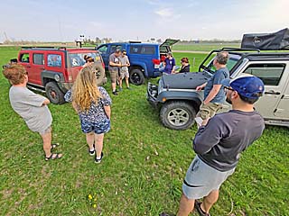
Chasers gather in a field anxiously waiting for storms near a corral south of Redfield, South Dakota on May 12. |
|
View of supercell "horseshoe" updraft and RFD (clear slot) with rotating wall cloud (just below the center of picture). This was southeast of Faulkton, South Dakota. The view is to the west. |
|
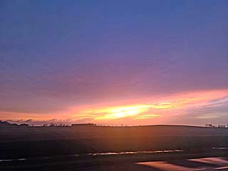
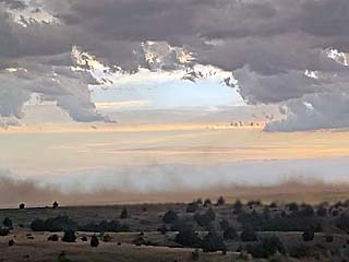
Sunset viewed from near Frankfort, South Dakota. This was behind a destructive MCS (derecho) of damaging straight-line winds that blew through to the south earlier. |
|
This is an annotated visible satellite image for the evening of May 13, around 1z the following UTC day. The synoptic setup is shown as well as supercell storms developing in a focused area in south-central Kansas and into north-central Oklahoma in twilight. These storms were developing where a stationary frontal boundary transects a diffuse dryline to the west. |
|
This is a radar (base reflectivity) image of a supercell storm east of Anthony, Kansas roughly 9 PM CDT. The weak Doppler velocity is in the inset to the upper-right. |
|
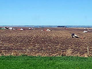
Debris in a field near Sioux Falls, South Dakota during the morning of May 13. This was from the May 12 "derecho", where winds exceeded 100 MPH in some areas. |
|
Convective initiation late in the day (after 0z) southwest of Wichita (near Harper County) Kansas. The view is to the southwest. |
|
Rapid development and back-sheared anvil of a supercell storm over Harper County, Kansas. The view is to the west and southwest. |
|
Updraft-downdraft interface of supercell rain-free base and hail core in Harper County, Kansas. The view is to the west and northwest. |
|
Impressive inflow bands / beavers tail feeding into the supercell storm at dusk in Harper County, Kansas and east of Anthony. The view is to the east. |
|
Rotating wall cloud at dusk in Harper County, Kansas and east of Anthony. The view is to the west. |
|
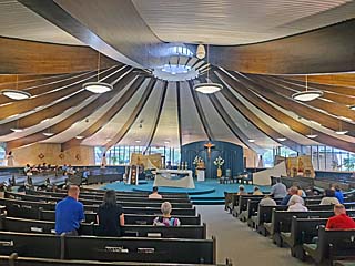
May 14 was down time taken in Wichita, Kansas to get some errands done (despite marginal chase prospects farther west), including vehicle maintenance such as an oil change and tire rotation. Here I am attending church in Wichita during the late afternoon. |
|
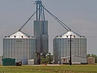
Typical scene in America's heartland. Grain bins and silos a common sight over the central USA near the KS / OK border. |
|
This is an annotated visible satellite image for the evening of May 15, around 23z. The synoptic setup is shown as well as supercell storms on-going in southeastern Oklahoma near a southward-progressing outflow boundary. |
|
This is a radar (base reflectivity) image of an HP supercell storm southeast of Wetumka, Oklahoma at roughly 6:30 PM CDT. The strong Doppler velocity is in the inset to the lower-right, depicting an intense, rain-wrapped low-level mesocyclone. |
|
Supercell storm initiating north of Hughes County, Oklahoma late in the day on May 15. The view is looking southeast from east of Stillwater, Oklahoma. |
|
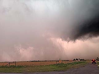
Punching through the intense HP supercell storm near Wetumka, Oklahoma. The storm had winds over 70 MPH and very large hail up to 3". The view is looking south after exiting the storm core, with the gust-front overhead. |
|
View of storm gust-front looking northeast, mainly "augmented" RFD. |
|
CG (cloud to ground) lightning strike and rotating wall cloud southeast of Wetumka, Oklahoma. The view is to the northwest. |
|
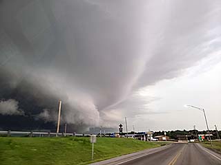
Powerful HP storm and rotating wall cloud southeast of Wetumka, Oklahoma. The view is to the WSW into the "notch" of the supercell storm. Intense velocity couplet also visible on Doppler radar at the time. |
|
Edge of updraft base and hail core, looking to the north out of Coalgate, Oklahoma as the storm weakens. Note the beautiful "green glow"! |

|
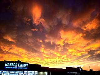
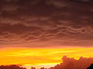
Some incredible mammatus observed on the backside of the storm complex near Hughes County, Oklahoma around sunset. |
|
View of line of towering cumulus to the southwest of Tulsa, OK after sunset. This was the outflow boundary that originally fired the storms. The view is to the WNW. |
|
May 16 was an off-day (in Tulsa, Oklahoma) and time spent working full time at my remote IT job. This is very convenient as I can work anywhere out of my hotel room or location I am at, even on the road. |
|
This is an annotated visible satellite image for the evening of May 17, around 23z. The synoptic setup is shown as well as supercell storms in the target area over the south-central Nebraska area. This was a highly complex setup for forecasting. |
|
This is a radar (base reflectivity) image of two supercell storms, just about to merge, near Harlan County, Nebraska at roughly 6 PM CDT on May 17. These storms were on the northeastern side of an MCS of storms. Note the left split off the storm to the top of the picture as well. |
|
High-based, elevated, linear convection developing south of Concordia, Kansas, during the afternoon of May 17. |
|
Storms developing looking west and northwest from near Smith Center, Kansas while en-route to the target area. |
|
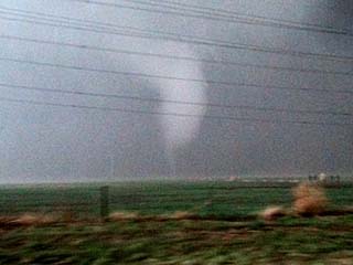
Brief funnel and rain-free base of severe storm near Harlan County, Nebraska. The view is to the west. |
|
High-based supercell storm on the NE side of a cluster of storms near Harlan County, Nebraska. The view is to the west. |
|
Brief wall cloud on eastern / leading side of the storm near Upland, Nebraska. The view is to the WNW. |
|
Anticyclonic left-split LP storm looking northward towards Kearney, Nebraska. |
|
Met up with Charles Edwards and Rocky Roscovich working for Cloud-9 Tours east of Cambell, Nebraska late in the day east of the severe storms. |
|
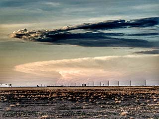
View to the west from north-central Kansas of after sunset sky. There is a distant supercell (probably near Sidney, Nebraska) storm casting a shadow on the cirrus layer at high altitude associated with the upper trough. |
|
May 18 was an off-day (in Hays, Kansas) and time spent working full time at my remote IT job. This is a miscellaneous picture of those "dreaded" one-lane traffic signals on a rural road. Thank God I am not rushing to a storm now! |
|
This is an annotated visible satellite image for the evening of May 19, around 23z. The synoptic setup is shown as well as severe storms in the target area over SE Minnesota. |
|
This is a radar (base reflectivity) image of severe storms, one a supercell, over SE Minnesota at roughly 7:30 PM CDT on May 19. The Doppler velocity is in the upper-right inset. |
|
Passing a lake just after sunrise in north-central Kansas off Highway 183 during the morning of May 19. This was the start of a very long drive to the target area. |
|
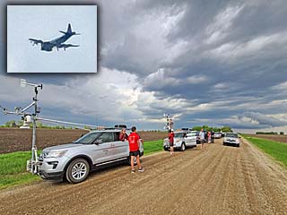
Storm research team (most likely with TWIRLS project) and mesonet vehicles near the warm front (looking east) north of Austin, Minnesota. The inset is a W-P3 "Orion" research aircraft flying overhead. |
|
Developing storm over Mower County and north of Austin, MN. becoming elevated and producing hail. The view is to the WNW. |
|
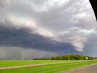
Intensifying outflow-dominant HP supercell entering Fillmore County, MN. The view is NE. |
|
Shelf cloud and area of rotation west of Preston, MN. The view is ENE. |
|
Powerful outflow and gust front near Preston, MN. The view is to the west. |
|
Anti-crepuscular rays and severe storm to the left looking east out of Spring Hill, MN at sunset. |
|
Bridge across upper Mississippi River near Lansing, Iowa looking east. Unfortunately, these beautiful bridges are slowly being replaced over the years and used for scrap. |

|
May 20 to the 24th was taken as off days due to marginal / poor chase prospects (except for "unexpected" activity in W Texas on the 23rd!) - Mainly working full time in the Chicago suburbs. In this picture I am in downtown Chicago on May 21 overlooking the Chicago river by night. |
|
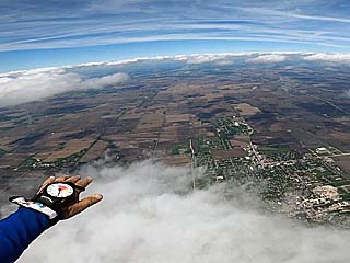
Skydiving near Rochelle, IL during the afternoon of May 22. |
|
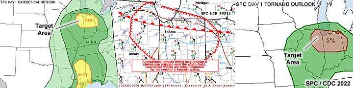
This is an annotated visible satellite image for the evening of May 25, around 22z. The synoptic setup is shown as well as storms in the area of interest over NE Illinois near Chicago. |
|
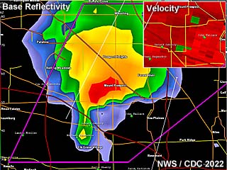
This is a radar (base reflectivity) image of a supercell storm west of Chicago during the afternoon of May 25, at roughly 4:30 PM. The Doppler velocity is in the upper-right inset. |
|
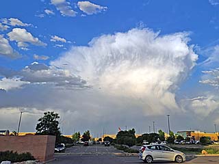
Supercell storm develops along the warm-front near Dupage / Cook County in NE IL during the afternoon (roughly 4:30 PM CDT) on May 25. The view is to the NE. |
|
Traffic and urban roads made documenting this storm difficult. Here is a view of the wall cloud / scud under the storm west of Chicago. The view is to the ENE. |
|
Rear flank and downdraft of the storm and powerful updraft before moving offshore into Lake Michigan. The storm was tornado warned and some small funnels were observed. The view is to the ENE. |
|
Replaced the windshield as well before heading back out during down-time from May 26-27. |
|
Non-severe elevated thunderstorms looking north of I-80 and east of Des Moines as an upper-level wave glances the area on May 28. This was a travel day to head back out west for storm prospects later in the Memorial Day weekend. |
|
This is an annotated visible satellite image for the evening of May 29, around 1z (the next day). The synoptic setup is shown as well as storms in the area of interest over north-central to central Nebraska, where a tornado-warned supercell storm has developed at dusk. |
|
This is a radar (base reflectivity) image of a supercell storm northwest of Taylor, Nebraska during the evening of May 29, at roughly 8:30 PM. The Doppler velocity is in the upper-left inset. |
|
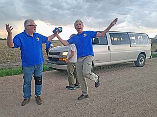
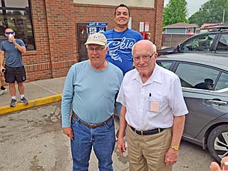
A large chaser convergence was at a gas station in Neligh, Nebraska during the afternoon on May 29. Tim Marshall is to the left, and Dave Hoadley to the right, as Scott Peake jumps up in the background "photo-bombing" the shot! |
|
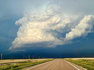
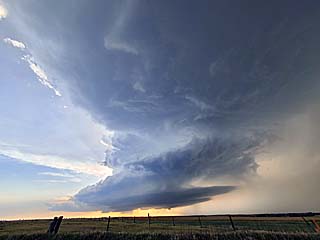
Late day supercell looms over the western sky as the cap erodes and convective initiation commences over Loup County, Nebraska. The view is to the west. |
|
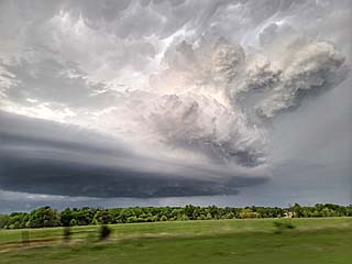
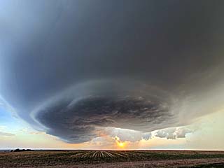
View of intensifying tornado-warned supercell storm northwest of Taylor, Nebraska. The laminar inflow "beavers tail" band can be seen extending left to right over the lower part of the picture, and explosive updraft overhead. The view is the northwest. |
|
Rotating wall cloud with the Loup County tornado-warned storm north of Taylor, Nebraska. |
|
Powerful MCS with straight line winds affects Sioux Falls, SD after midnight, early on May 30, with winds gusting over 75 MPH. |
|
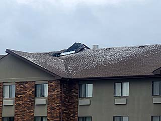
Roof damage the following morning from the powerful straight-line winds that went through to a hotel next to mine. |
|
This is an annotated visible satellite image for the afternoon of May 30, around 20z. The synoptic setup is shown as well as severe storms stretching from SE South Dakota and NE Nebraska and into SW Minnesota. |
|
This is a radar (base reflectivity) image of a line segment / developing supercell storm west of Lake Benton, Minnesota during the afternoon of May 30, at roughly 2:30 PM. |
|
Australian storm chaser Dan Shaw working on his vehicle before storms in Pipestone, Minnesota on May 30. |
|
Very fast moving storms developing and moving northward to near Lake Benton, Minnesota. The view is northwest. |
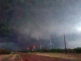
|
View of surging MCS and outflow looking north of Highway 14 with wind turbines. The view is to the north. |
|
DOW (Doppler On Wheels) vehicle along Highway 14 in south-central to SW Minnesota (most likely with TWIRLS project). |
|
View looking east towards the dryline and struggling convection south of Windom, Minnesota late in the day. |
|
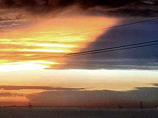
Sunset and approaching Pacific cold front looking west from near Lake View, Iowa. |
|
This is an annotated visible satellite image for the afternoon / early evening of May 31, around 23z. The synoptic setup is shown as well as some supercell storms along a boundary stretching from the SE Texas panhandle and into west-central Oklahoma. |
|
This is a radar (base reflectivity) image of a supercell storm northeast of Elk City, Oklahoma on May 31, at roughly 5 PM. The Doppler velocity is in the image to the upper-right. |
|
Stopping by the Samaras Memorial near El Reno, Oklahoma during a long drive to the target region around noon on May 31. Speaking of "May 31", it was this same tragic day in 2013 where these three scientists (Tim, and his son, Paul Samaras, and Carl Young) were killed in the largest tornado in history. |
|
Storms initiating along the stalled frontal boundary by mid to late afternoon near Elk City, Oklahoma on May 31. The view is to the west. |
|
Another DOW truck (Doppler On Wheels) along the side of SR 34 and north of Elk City, Oklahoma. This was scientist Howie Blustein's team. |
|
Rotating wall cloud rapidly forms with an intensifying supercell northeast of Elk City, Oklahoma. The view is to the northwest. |
|
View at rapidly rotating wall cloud over Foss Lake / reservoir. Note the gustnado spraying up water in the lake along the leading edge of the RFD! The view is to the northwest. |
|
Multi-vortex gustnadoes over Foss Reservoir. The view is northwest. |
|
Funnel cloud within the "bear's cage" of the supercell storm near Arapaho. The view is to the northwest. |
|
Possible brief tornado north of Arapaho. The view is northwest. |
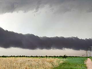
|
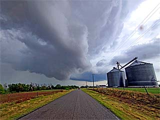
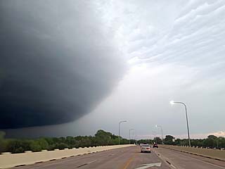
Menacing view of storm and gust front / shelf cloud near Weatherford, Oklahoma. The view is to the north. |
|
Mammatus overhead in Elk City at dusk as the sun sets below the horizon. The view is to the northwest. |
|
Closer view of mammatus and brilliant colors after dusk. |
|
This is an annotated visible satellite image for the afternoon / early evening of June 1, around 22z. The synoptic setup is shown as well as supercell storms south of and along a cold front in SW Texas / SE New Mexico. |
|
This is a radar (base reflectivity) image of a supercell storm near Jal, New Mexico on June 1, at roughly 5 PM. The Doppler velocity is in the image to the upper-right. |
|
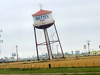
Famous "leaning water tower" along I-40 while heading west to Amarillo during the morning / noon of June 1. |
|
Cold front southwest of Lubbock, Texas during the afternoon with dust kicked up in the gusty cooler air north of the front. The view is to the northeast. |
|
Supercell developing over Lea County, New Mexico and west of Jal. The view is to the SSW. |
|
Wall cloud and RFD outflow of the powerful supercell storm west of Jal, New Mexico. The view is to the west. |
|
Area under rotating wall cloud (RFD dust and possible weak / broad tornado) west of Jal. The view is WSW. |
|
Second supercell developing southwest of Andrews, Texas during the early evening. The hail core is to the left with powerful "augmented" RFD surging left to right. The view is to the ENE. |
|
Strong winds associated with the backside of the Andrews supercell. Winds here are gusting over 70 MPH at times. |
|
Major hail swath, with heavy accumulations of hail (at least several inches deep), ranging from marble to golf-ball sized, along SR 115 southwest of Andrews. |
|
View of hail covering the terrain right of SR 115 southwest of Andrews. |
|
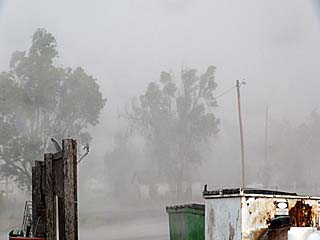
Hail fog reduces visibility southwest of Andrews, Texas. |
|
Cold front and powerful wind shift kicks up dust at sunset looking west from near Lamesa, Texas at dusk. |
|
Hotel in Lubbock during down-time and IT work on June 2. |
|
This is an annotated visible satellite image for the late afternoon of June 3, around 22z. The synoptic setup is shown as well as supercell storms stretching from SE Colorado to SW Texas across eastern NM as well as in the area of interest over SE New Mexico in an up-slope wind flow regime. |
|
This is a radar (base reflectivity) image of an LP supercell storm southwest of Artesia and northwest of Carlesbad, New Mexico during the afternoon of June 3, at roughly 4:30 PM. Note the low reflectivity values despite the storm producing large hail, as well as the rather strong Doppler velocity is in the upper-right inset. |

|
Street lamps in Roswell, New Mexico painted like little green alien heads! Today (June 3) was a chase day in SE New Mexico. |
|
Two LP (low-precipitation) supercells developing west of Artesia, New Mexico during the afternoon of June 2. |
|
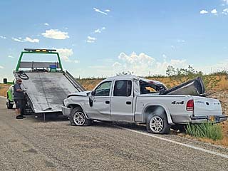
Accident along the side of the road (not weather related). It appears a pickup truck lost control and hit the rocks along the side of the roadway (SR 13 northwest of Hope, NM). |
|
Small funnel (just above center of picture) associated with the more dominant, right-moving LP storm west of Hope, NM. |
|
LP supercell storm peaking in intensity northwest of Carlsbad, New Mexico during the late afternoon with gorgeous structure. |
|
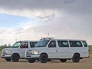
Chase tour vans a common sight in a "supercell environment". |
|
While heading east by the TX / NM border, many fires can be seen at night, each a "flare" for petroleum facilities. |
|
This is an annotated visible satellite image for the evening of June 4, around 0z (the next day). The synoptic setup is shown as well as supercell storms developing in an up-slope regime / near a frontal boundary from NE Colorado and into SW Nebraska. |
|
This is a radar (base reflectivity) image of an LP supercell storm near Cope, Colorado at around 4:00 PM, MDT. |
|
This is a radar (base reflectivity) image of supercell storms north of Oberlin, Kansas at around 8:30 PM, CDT. Base reflectivity outlines the rotation of the storms, as well as an intense hail core. The Doppler velocity is in the upper-left inset. |
|
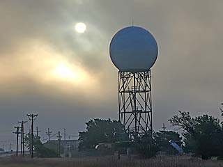
Departing Amarillo and passing their NWS WSR-88D radar while heading northeast early on a foggy morning of June 4. |
|
Convective initiation northwest of Cope, Colorado during the afternoon. The view is to the northwest. |
|
Looking west over I-70 towards Seibert, CO at the LP storm pushing southeast with storm structure. |

|
Small funnel developing in the RFD region of the LP supercell overhead and southeast of Cope, Colorado. |
|
Small anticyclonic funnel looking west at another severe storm west of Goodland, Kansas. |
|
Distant view of a developing supercell storm southeast of North Platte, Nebraska (from near Goodland, Kansas). The view is to the northeast. |
|
The storm that was southeast of North Platte, NE finally moves southward and into Kansas, and was encountered near Oberlin. This was a powerful supercell, and an explosive updraft can be seen on the southern split of this cell. The view is to the east on Highway 36. |
|
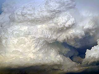
Closer view of the main updraft of the supercell with rock-hard, "cauliflower" like appearance to the updraft stack. |
|
I cannot identify what this is from this distance, but it appears to be the powerful mesocyclone north of the southern split of the supercell near Oberlin, Kansas. The view is to the northeast. Possible large rotating wall cloud? |

|
Rapid rotation and cyclonic funnel overhead north of Oberlin. Note the RFD to the lower right, and clockwise (anti-cyclonic) portion as well. |
|
Rapidly rotating, and outflow dominant northern "split" of the storm catches up with the southern development, with rapid rotation over Highway 83 north of Oberin, KS. The view is to the north. These colors looked more like a "storm on the planet Jupiter"! |
|
Possible weak tornado (dust on ground) before outflow from the northern storm cuts off the southern split. The view is to the east. |
|
Dust kicked up west of the storm and west of Highway 83 as some outflow winds to hurricane forced were encountered earlier. The view is to the west and southwest. |
|
This is an annotated visible satellite image for the early evening of June 5, around 23z. The synoptic setup is shown as well as supercell storms developing in the target area(s) near a stalled frontal / outflow boundary from SE Colorado and into SW Nebraska. |
|
This is a radar (base reflectivity) image of supercell storms near Powers and Baca Counties in SE Colorado at around 5:30 PM, MDT. Base reflectivity shows the supercell storm and core as it pushes southeast. The Doppler velocity is in the upper-right inset. |
|
Storms begin initiating along a stalled boundary during the afternoon of June 5 near Oakley / Colby Kansas and southwestward. The view is to the west. |
|
Short lived, high based storm northwest of Oakley, Kansas. Note the high based wall cloud to the lower right. The view is to the WNW. |
|
Headed south towards Tribune, Kansas with the laptop in the vehicle showing a supercell storm to the west. |
|
Classic supercell looking west from south of Holly, Colorado and heading towards Walsh. The view is to the west. |
|
Intense classic / LP storm north of Walsh, CO. The view is to the west. |
|
Another view of the Baca County / Walsh, CO storm. The view is to the WNW. |
|
Powerful winds and hail nip the east side of Walsh, Colorado, mainly with the RFD of the storm. |

|
Golf-ball sized hail collected from the ground east of Walsh, CO after passage of the storm core in Highway 160. |
|
Down-scaling of LP storm, with impressive mid-level rotation looking east as the storm moves south across Baca County near Dusk. |
|
View of distant supercell storm, most likely north of Colby, Kansas at dusk, most likely 150 to 200 miles away now. The view is to the north. |
|
This is an annotated visible satellite image for the evening of June 6, around 1z (the following day). The synoptic setup is shown as well as supercell storms developing in the my target area (near SE Colorado) as well as another distant area in Nebraska where some chasers targeted. |
|
This is a radar (base reflectivity) image of a supercell storm southwest of Lamar, Colorado at around 6 PM, MDT. Base reflectivity shows the supercell storm and core as it pushes east and south of Lamar. |
|
View of distant supercell (40 miles away) as it was southeast of La Junta, Colorado from south of Lamar and north of Springfield. That is NOT a tornado under it, but a hail shaft with sun reflecting off it. The view is to the west during the afternoon of June 6. |
|
Approaching high-based supercell and hail core near Lamar, Colorado. The view is to the west. |
|
Intense core of a supercell passing south of Lamar, Colorado. Winds were measured gusting over 80 MPH with this storm. |
|
Copious amounts of small hail covering the ground after passage of a severe thunderstorm in Lamar, Colorado. |
|
View of high-based supercell after it passed southeast of Lamar, Colorado. Note the hail core to the left. The view is to the Northeast. |
|
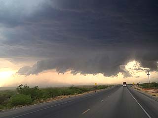
Impressive supercell storm (over the N Texas Panhandle) and back-sheared anvil looking south from the Oklahoma Panhandle. The view is to the south. |
|
Impressive structure of northern split of the Texas supercell just before dusk. Note the hail core. The view is to the east. |
|
This is an annotated visible satellite image for the evening of June 7, around 0z (the following day). The synoptic setup is shown as well as supercell storms developing in the my target area (near NE Colorado) as well as another areas farther south. |
|
This is a radar (base reflectivity) image of a supercell storm west of Julesburg, Colorado (while it was producing a small tornado near Sedewick) at around 5 PM, MDT. The Doppler velocity is in the upper-right inset. |
|
Heading north during a long drive from the Oklahoma Panhandle to extreme NE Colorado by late afternoon on June 7. This is neading north on Highway 385 approaching Julesburg, Colorado as storms fire looking north. |
|
A supercell storm intensifies west of Julesburg, Colorado and near Sedgwick. The view is to the west, showing a rotating wall cloud and classic supercell structure. |
|
A tornado develops and passes over Sedgwick, Colorado with dust cloud and strong rotation (note swirl in cloud base above). This tornado was not very strong, but observed at close range. The view is to the northwest. |
|
View of possible tornado (to lower left), looking northeast at the RFD region of the Sedgwick supercell while heading south. |
|
Funnel (just above farmstead left of center) as tornado dissapates in the RFD region. The view is to the northeast. |
|
Wall cloud on another supercell storm near Holyoke, Colorado. The view is to the north. |
|
Powerful inflow tail into the Holyoke storm. This is a horizontal "rotor" associated with the streamwise vorticity current feeding into the storm. The view is to the north. |
|
Powerful outflow winds kick up dust as the storm enters Chase County, Nebraska. The view is to the south. |
|
Hail falling in Chase County, Nebraska west of Imperial and south of Lamar. The hail was mostly quarter to golf-ball sized, but some isolated pieces to tennis and baseball sized was observed. |
|
Hail covering a farm road and hail fog developing south of Lamar, Nebraska in Chase county. |
|
Hail fog and hail covering the roadway (heading east on Highway 6) west of Imperial, Nebraska. |
|
Doppler on Wheels (DOW) truck associated with the TWIRLS project near Imperial, Nebraska shrouded with hail fog. |

|
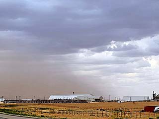
Colors looking east at dusk as storms evolve to an MCS of severe storms and move east. |
|
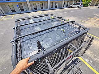
June 8 was an off-day (no storms) spent in Hays, Kansas. Here I am inspecting the hail guards atop my vehicle after large hail pummeled them a day earlier. |
|
This is an annotated visible satellite image for the evening of June 9, around 1z (the following day). The synoptic setup is shown as well as supercell storms developing in the my target area in SW Nebraska as well as severe storms in another areas farther south. |
|
This is a radar (base reflectivity) image of a supercell storm northwest of McCook, Nebraska just after 8 PM, CDT. The Doppler velocity is in the upper-right inset. |
|
Two small LP (low precipitation) and high-based supercell storms after a storm split southwest of Holyoke, Colorado late in the day on June 9. These are not in the main target area, but associated with the upper-level disturbance approaching the area. |
|
Surface-based convective initiation looking to the northeast over SW Nebraska from near Holyoke, Colorado in my main target area. |
|
Explosively intensifying supercell looking east and northeast towards Lincoln County, Nebraska. |
|
Possible weak / brief tornado (dust) with RFD looking northeast from near Dickens, Nebraska as the storm rapidly intensifies. This wall cloud was rapidly rotating as well. |
|
Developing inflow tail and low-level mesocyclone looking west from north of Wellfleet, Nebraska in Lincoln County. |
|
LP (low precipitation) supercell and structure looking west from south of Wellfleet, Nebraska. |
|
Impressive horse-shoe updraft and RFD and LP storm structure of the updraft base near Maywood, Nebraska. The view is to the west. |
|
Impressive "mother-ship" appearance of the south side of the supercell storm northwest of McCook, Nebraska in Frontier County. The view is to the southwest. |
|
Supercell storm, lit by dusk and moonlight, crosses into Kansas southeast of McCook, NE after dark. The view is to the east. Note the impressive inflow band. |
|
Closer view of inflow tail and main updraft of the down-scaling supercell well after dark. The view is to the east. |
|
June 10 and 11 were off days spent in Denver, Colorado. Here a non-severe storm billows east of the area late in the day on June 10. |
|
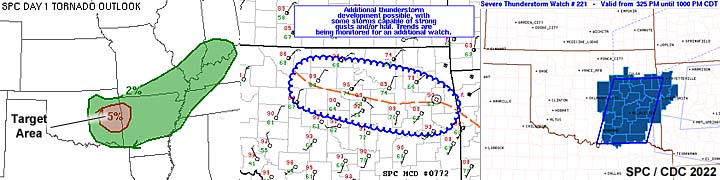
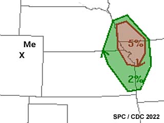
Scary moments - After committing to down-time in Denver, a "surprise" severe weather setup appears way back east with a 5% tornado probability. Fortunately I did not miss much. |
|
Apparently there was a small fire at the hotel I was staying at during my down time. |
|
This is an annotated visible satellite image for the evening of June 12, around 0z (the following day). The synoptic setup is shown as well as supercell storms developing in the my target area and moving into western South Dakota. Some high-based severe storms also developed in another areas farther south. |
|
This is a radar (base reflectivity) image of two supercell storms near the WY / SD border around 6:30 PM MDT. These were mostly outflow dominant but produced incredible amounts of large hail. |
|
Convective initiation of severe storms north of Gilette, Wyoming during the afternoon of June 12. The view is to the WNW. |
|
Impressive wall cloud associated with rotation on the south side of a powerful bow / MCS north of Sundance, Wyoming. The storm was outflow dominant. The view is to the north. |
|
Not sure what this was, but I'll call it a funnel as it was rotating north of Beulah, Wyoming. The view is to the north with a hill blocking view of the ground. |
|
Hail covers I-90 near Sturgis, SD. |
|
Wall cloud of supercell storm near Sturgis, South Dakota as it is undercut by outflow. The view is to the north. |
|
This is an annotated visible satellite image for the evening of June 13, around 1z (the following day). The synoptic setup is shown as well as supercell storms developing in the my target area in western South Dakota as well as other storms farther south. |
|
This is a radar (base reflectivity) image of a severe storm with weak rotation in Butte County, South Dakota just after 7:30 PM MDT. The Doppler velocity is show in the upper-right inset. |
|
Devils Tower national monument near Sundance, Wyoming before chasing storms on June 13. |
|
Convective initiation of severe storms west of Belle Fourche, South Dakota along a slow-moving cold front during the late afternoon of June 13. The view is to the west. |
|
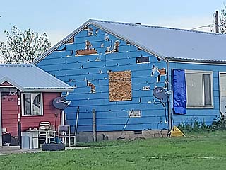
Hail damage to the side of a home in Belle Fourche, South Dakota from a major hail storm a day earlier. |
|
Small supercell storm looking northward from Highway 212 west of Newell, South Dakota with wall cloud / possible funnel. |
|
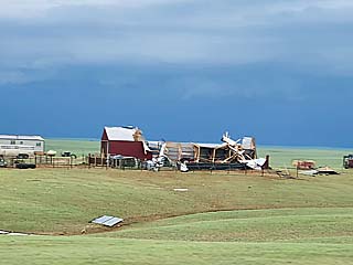
Destroyed farm house west of SR 79 north of Newell, South Dakota. This was from a potent MCS a day earlier with winds gusting over 90 MPH. |
|
Small supercell storm on the leading edge of an MCS / cold front before being undercut by outflow south of Newell, South Dakota. The view is to the southwest. |
|
View of rotating storm / leading edge of supercell in an MCS in Butte County, South Dakota. The view is to the northwest. |
|
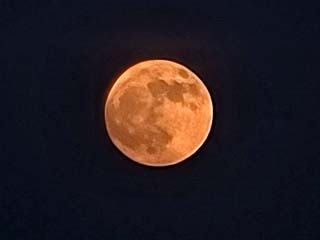
Red colored full moon rising above the horizon after dusk while heading east on Highway 212 towards Faith, South Dakota. |
|
Moonlit sky driving south on SR 73 south of Faith, South Dakota well after dark. |
|
This is an annotated visible satellite image for the evening of June 14, after 1z (the following day). The synoptic setup is shown as well as supercell storms developing in the my target area in SE Nebraska and along a stalled / cold frontal boundary draped from SW to NE. |
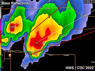
|
This is a radar (base reflectivity) image of a supercell storm with weak rotation and large hail in Gage County, Nebraska just after 8 PM MDT. |
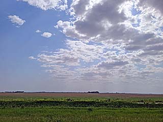
|
After a long drive from south-central South Dakota, a slow moving cold front, and associated cloud deck, is encountered southwest of Omaha, Nebraska during the late afternoon of June 14. |
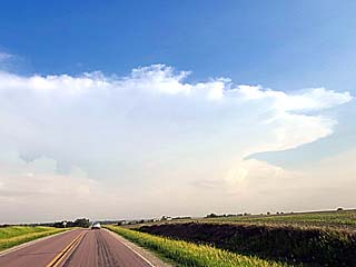
|
Convective initiation of severe storms south of Lincoln, Nebraska along a stalled cold front during the late afternoon of June 13. The view is to the south. |
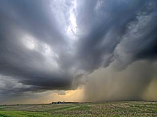
|
Wide view of a powerful supercell storm developing on the SW side of a line of strong and severe storms near Adams, Nebraska. Note the hail core to the lower-right. The view is to the west. |
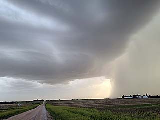
|
Close up of base and hail core (right) of a supercell in Gage County, NE near Adams. A hail roar was also audible at the time. The view is to the west. |
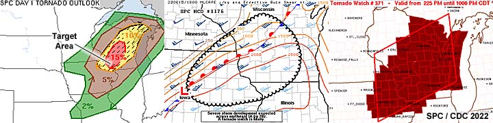
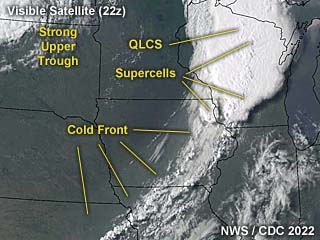
|
This is an annotated visible satellite image for the afternoon of June 15, around 22z. The synoptic setup is shown as well as severe storms in the my target area in NE Iowa and much of Wisconsin. |
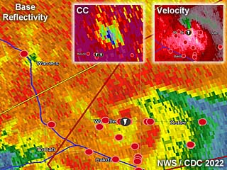
|
This is a radar (base reflectivity) image of an embedded QLCS supercell storm with a strong tornado near Tomah, Wisconsin just after 4 PM CDT. The Doppler velocity is in the inset to the upper right and corellation-coefficient (showing a TDS or tornadic debris signature) in the upper inset left of that. |
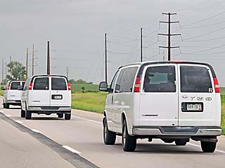
|
Three tour vans (probably with "Silver Lining Tours" / Roger Hills team) make their way north on I-35 during the afternoon of June 15. |
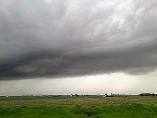
|
A small convective cell develops in extreme NE Iowa as messy convection initiates in the area during the afternoon. The view is to the northwest. |
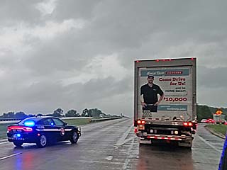
|
Roadblock along I-90 near Tomah, Wisconsin due to tornado damage in the area. This was the END of the chase. |
|
Damage along I-90 near Tomah, Wisconsin. Power poles are snapped, semi-trucks are overturned, and the interstate is closed. This was the path of a QLCS tornado embedded in the line of storms. |
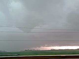
|
View of leading edge of MCS (line of severe storms) east of I-90. The view is to the east. |

|
June 16 through the 18 were travel days and the end of this chase expedition. Here I am passing downtown Chicago on a hot afternoon of June 16. |
|
Crossing into Kentucky to change over from I-65 to I-64 on June 16. This is the old bridge across the Ohio River still in use - And still free (the new bridge is nearly a $5 toll)! |
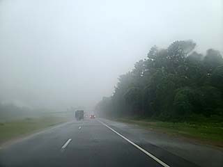
|
Penetrating a severe storm on I-75 near Athens, Tennessee during the afternoon of June 17. |
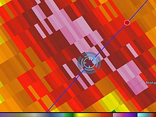
|
Radar image of the severe storm near Athens, and my position (in the core)! |
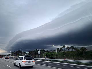
|
Beautiful shelf cloud (gust front from a non-severe storm) moving across south Florida late in the day on June 18. A severe thunderstorm watch was also in effect for this area. |
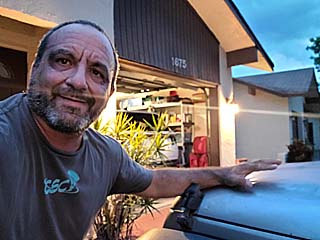
|
Myself giving my 2016 Jeep Wrangler a pat as I safely arrived home during the evening of June 18. |
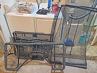
|
Hail guards removed and ready to go back into storage. |
HTML File "mwcl2022.htm" - Developed By Chris Collura
To Return To The HOME Page Of This Site Click The "INDEX.HTM" Link Here!