
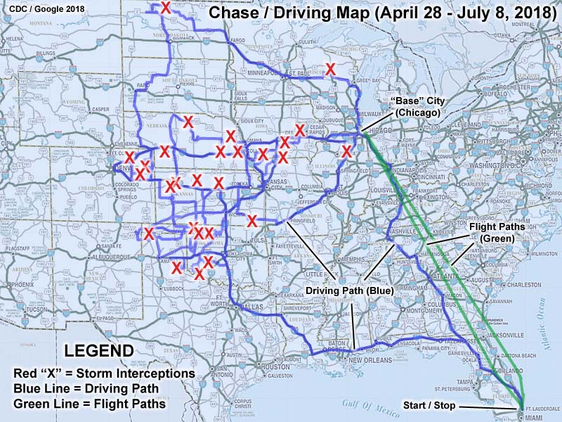
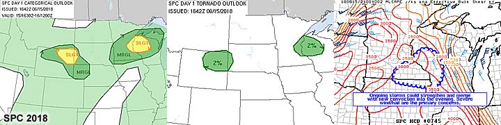
| This section is for storm chases done in the central / Midwestern United States during the year of 2018. This includes all storm chasing activities (including any major chase "expeditions") during the year of 2018 in the central USA (aka "Tornado Alley"). For 2018, all chases in the central USA will be logged in this section, with many of the chases being possible "spot" chases / major severe weather "setups" chased. Here you should find many pictures of lightning, tornadoes, hail, strong winds, along with many severe thunderstorm elements. Keep in mind that this chase log is scientific evidence and portrays my on-going storm chasing research. It has been placed on this page for easy reference and meteorological interests. Please do not plagiarize or copy this document to other sites for distribution. Note - This page may take a while to load on some SLOWER connections! |
STORM CHASING - CENTRAL UNITED STATES - 2018 CHASE LOG
| CHASER NAME | HOME / BASE CITY | CALLSIGN | CHASE DATES | OCCUPATION |
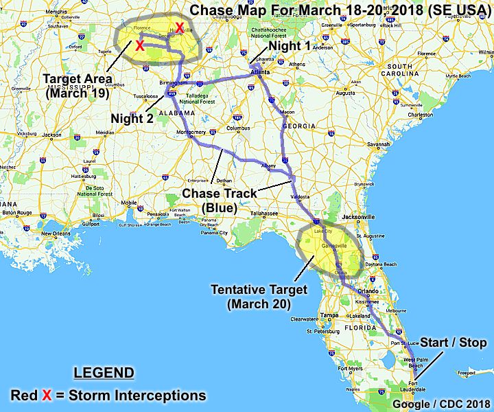
| CHRIS COLLURA | DEERFIELD BEACH, FL | KG4PJN | 3-18 TO 3-20 | IT CONSULTANT |
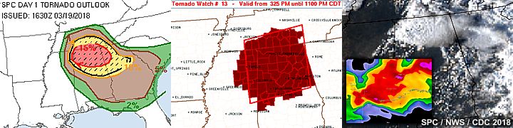
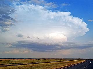
1). March 23, 6:30 PM - Interception and observation of a very severe thunderstorm north of Huntsville and near Meridianville in Madison County, Alabama and along Highway 231. The storm was a high precipitation supercell storm, which initiated much farther west earlier near Courtland west of Decatur in Lawrence County and was followed east on Highway 72 and through Huntsville via I-565. The storm was fast moving. The core of the supercell was encountered near Meridianville and contained 60 MPH, frequent lightning, heavy rains, and hail to golfball sized (covering the ground at a gas station off Highway 231). A low area of rotation was also observed with this storm, but no tornadoes developed. Conditions causing the storm were a warm front, surface heating, low pressure trough, and upper trough. Documentation was still photos and digital HD video. A 2016 Jeep Wrangler was used to chase the storm. A PDS (particularly dangerous situation) tornado watch was also valid for the area until 11 PM CDT.
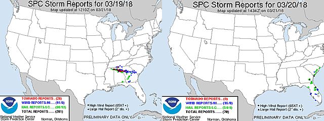
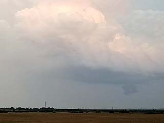
2). March 24, 8:30 PM - Interception and observation of an extremely severe and tornadic thunderstorm from west and through Russellville in Franklin County Alabama along Highway 24 and east and southeast through Moulton and Cullman along Highway 157 and ultimately near Summit in Cullman County and Highway 231. The storm began as a powerful classic supercell that evolved to HP near Russellville as it turned right (moving ESE). The main core of the storm was not penetrated, but contained hail to at least baseball sized (with record breaking hail sizes exceeding 5" near Cullman). The storm had a striking visual appearance as well, with rapidly rotating wall cloud and striated updraft and vault to the right when viewed west of Russellville. The storm produced a rain wrapped tornado that caused damage in Russellville. This tornado was barely visible from the east on Highway 24 looking towards Russellville. The storm continued rapidly east and southeast and a split occurred near Brooksville and ultimately caused another tornado that hit Jacksonville, AL. Conditions encountered were heavy rains, small hail (main core avoided), frequent lightning with close hits, and winds near 60 MPH (mainly inflow and RFD). This is the same storm that caused extreme hail near Cullman, where a record breaking (AL state record) hailstone of 5.25" fell! Conditions causing the storm were a stationary front / outflow boundary, surface heating, low pressure area, and upper trough. Documentation was still photos and digital HD video. A 2016 Jeep Wrangler was used to chase the storm. A PDS (particularly dangerous situation) tornado watch was also valid for the area until 11 PM CDT.
This concludes the chase log for the SE USA (including chases in Alabama) chase trip for March 18-20, 2018. The summary includes a total of 2 observations, out of which there were 2 severe thunderstorms. A tornado was observed from one of these severe storms. The main chase vehicle conducting this chase a 2016 Jeep Wrangler. This information was prepared exclusively for the National Weather service and the team of Skywarn storm spotters.
|
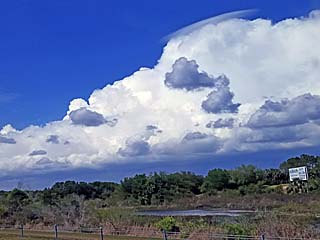
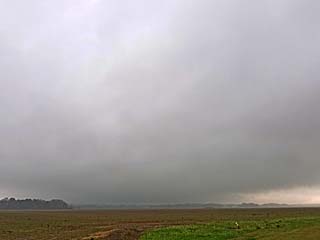
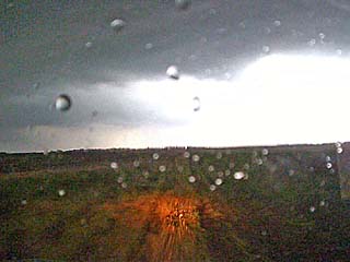
Non severe storm in central Florida while beginning a long road trip to Georgia and Alabama during the afternoon of March 18, 2018. |
|
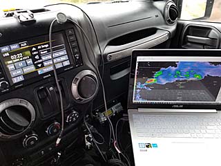
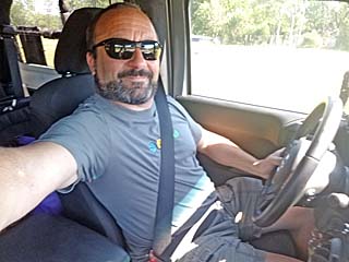
Inside of my chase vehicle (a 2016 Jeep Wrangler) ready to chase on March 19, 2018. |
|
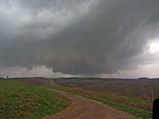
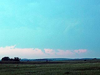
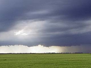
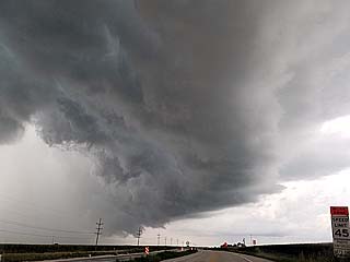
Area of rotation to the southwest of Courtland, Alabama on the first supercell of the day on March 19. This was along the warm front and storm motions were fast and visibility poor. |
|
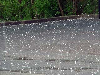
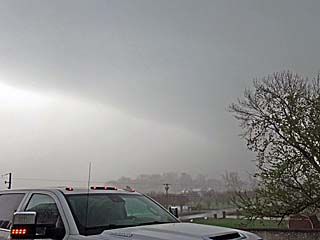
Hail up to golfball sized affecting Meridianville, Alabama north of Huntsville around 4 PM on March 19. |
|
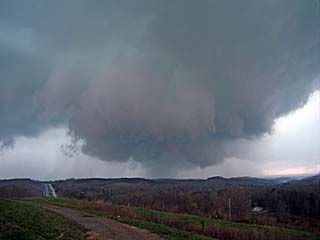
View of backside of the hail core and area of weak rotation on March 19 near Meridianville, Alabama. |
|
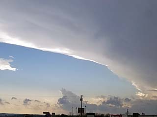
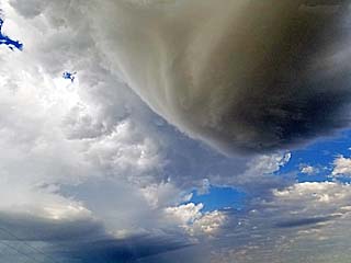
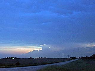
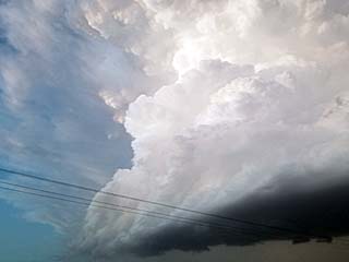
View of impressive anvil blowoff from an intensifying tornadic supercell west of Russellville, Alabama after 6 PM in Franklin County. |
|
Supercell storm (in classic mode) to the west of Russellville, Alabama on Mrch 19. This is an intensifying storm and will produce a weak tornado soon. |
|
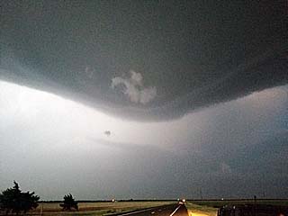
Close-up view of rotating wall cloud to the west of Russellville, Alabama. |
|
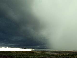
Intense rain-wrap and hail core while looking west towards Russellville, Alabama. There is a developing rain-wrapped tornado in there, and significant damage was being done in Russellville at the time. |
|
Closer view of rain-wrapped tornado as is was doing damage in Russellville, Alababa. The tornado would be to the lower-left of the center of this picture. |
|
Highway 82 in eastern Alabama extending into a "traffic-less" vanishing point while heading east of Montgomery on March 20, 2018. |
|
Low topped non-severe storm west of Orlando while heading back to south Florida late in the day on March 20. |
| CHASER NAME | HOME / BASE CITY | CALLSIGN | CHASE DATES | OCCUPATION |
| CHRIS COLLURA | DEERFIELD BEACH, FL | KG4PJN | 4-28 TO 7-8 | IT CONSULTANT |
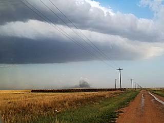
1). April 30, 6:15 PM - Interception and penetration of a severe thunderstorm from near Memphis and Wellington, in Collingsworth County, Texas and along Highway 287 and SR 256 and northward on Highway 83 to near Shamrock. The storm was a multicell storm that evolved to a supercell, which ultimately split. The right split weakened with the left split becoming a sculpted LP (low precipitation) supercell that raced northeastward to near Shamrock, Texas, where it weakened via down-scaling Conditions encountered were heavy rains, 50 MPH winds, 1" hail, and frequent lightning. The storms were caused by a dryline, surface heating, low pressure trough, and an upper trough. A 2016 Jeep Wrangler was used to chase the storms. Documentation was digital stills and audio. A severe thunderstorm watch was also valid for the area until 11 PM CDT.
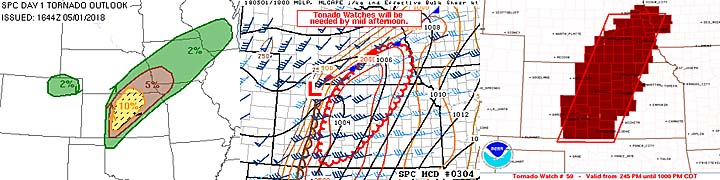
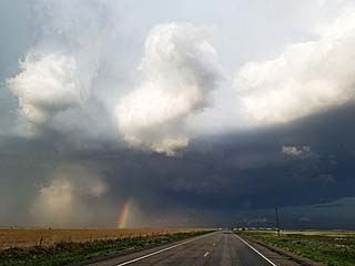
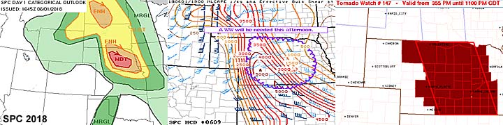
2). May 1, 5:00 PM - Interception and observation of a very severe and later tornadic thunderstorm north of Russell, Kansas in Russell County, from along Highway 281 and to south of SR 18 near Waldo. The storm was a classic to HP supercell storm. A rotating wall cloud was observed with this storm, but it was abandoned for a better second supercell to the south. Eventually this storm will move NE and produce a large tornado near Concordia. The core was not penetrated, but contained hail at least golfball sized and 60 MPH winds. Heavy rain, small hail, and frequent lightning was encountered. The storm was caused by surface heating, a low pressure area, dryline / stationary front interactions, and an upper trough. A 2016 Jeep Wrangler was used to chase the storms. Documentation was HD video and digital stills. A tornado watch was also valid for the area until 10 PM CDT.
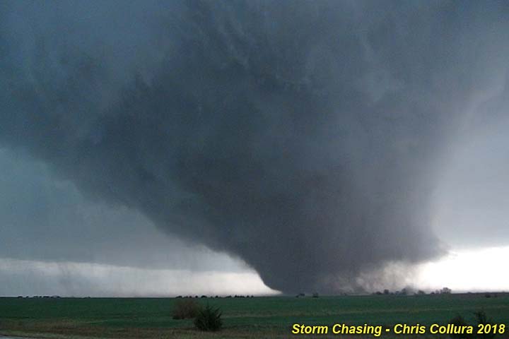
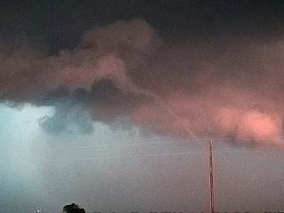
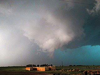
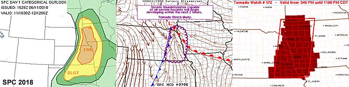
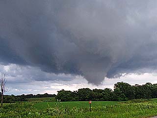
3). May 1, 7:30 PM - Interception, observation, and direct penetration of an extremely severe and tornadic thunderstorm from near NW 150 Road and Highway 281 in Hoisington, Kansas in Barton County and northeastward to Ellsworth near I-70 and Highway 14, and eventually into Ottawa County east of Tescott and south of Minneapolis near SR 18 and Highway 81. This storm was a powerful cyclic supercell, mostly classic mode. The storm was first encountered around 6:15 PM near Hoisington and east of Otis, Kansas, and 60 MPH winds, frequent lightning, moderate rain, and extremely large hail between baseball and grapefruit sized (at least 3") were observed. The large hail damaged the HAM antenna on the chase vehicle, bending it almost in a loop and breaking the base (the hail guards protected the windows as intended). The storm also had a rotating wall cloud and a funnel was observed near Hoisington. The storm cycled down and was tracked to the north of Ellsworth, where a small tornado (rated EF-0) was observed near SR 14 and just south of I-70 at about 7:00 PM. Continuing east on I-70 and north to SR 18 to the east of Tescott, and very large and dangerous tornado was observed over open country between 7:30 and 8 PM CDT. This tornado was rated EF-3, with a maximum width of 1/2 a mile. The entire life cycle of this wedge tornado was documented at close range, until occlusion and demise to the SW of Minneapolis, KS and NW of Bennington. Within this tornadic environment, some light debris was noted falling from the sky, with hail bouncing by exceeding 2" and 70+ MPH winds (inflow jet and RFD) with eventual heavy rain wrap. The storm also had frequent lightning and a striking visual appearance, with an appearance of an "upside down wedding cake" or "stack of plates", inflow beavers tail, and with full RFD cut with the wedge tornado beneath it. Fortunately this tornado remained over rural country. Power poles along SR 18 were snapped, and ground scouring was also noted. The storm was caused by surface heating, a low pressure area, dryline / stationary front interactions, and an upper trough. A 2016 Jeep Wrangler was used to chase the storms. Documentation was HD video and digital stills. A tornado watch was also valid for the area until 10 PM CDT.
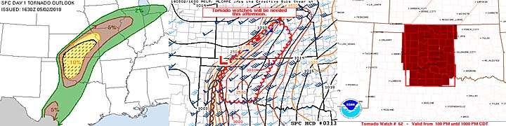
4). May 2, 7:00 PM - Interception and penetration of a very severe and possibly tornadic thunderstorm from east of Cordell, Oklahoma and Highway 183, and eastward along Highway 152 through Binger in Caddo County and southeastward to NW of Chickasha and south of Minco along Highway 81. The storm was an HP supercell storm, and produced only some brief tornadoes (and / or gustnadoes). The storm was penetrated, and small hail (penny sized), 60 to 70 MPH winds, frequent lightning, and heavy rains were observed. The storm eventually split and evolved to a damaging bow segment with wind over 70 MPH during the late evening after passing Chickasha and eventually south of the Oklahoma City area well after dark. Flooding and tress down was observed with this storm. The storm was caused by surface heating, a low pressure area, dryline, and an upper trough. A 2016 Jeep Wrangler was used to chase the storms. Documentation was HD video and digital stills. A tornado watch was also valid for the area until 10 PM CDT.
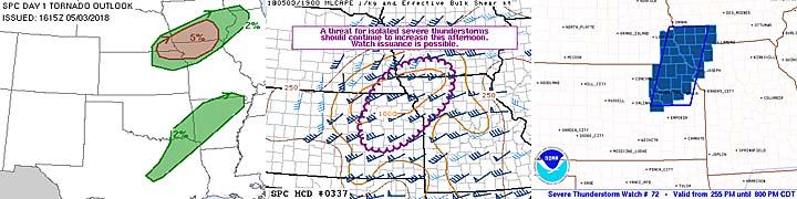
5). May 3, 5:30 PM - Interception and observation of a severe thunderstorm from near Tarkio, Missouri in Atchinson County near Highways 59 and 136 and eastward to near Bedford in Taylor County, Iowa near SR 148. The storm was a small supercell storm, starting out in classic mode with a wall cloud and weak rotation, evolving to HP, then a bow segment. The core of this storm was not directly penetrated and 50 MPH winds, frequent lightning, small hail, and heavy rains were encountered. An area of rotation was noted, with an RFD slot and wall cloud, but did not last long. The storm was caused by surface heating, a low pressure area, wave apex of cold and warm front, and an upper trough. A 2016 Jeep Wrangler was used to chase the storms. Documentation was digital stills. A severe thunderstorm watch was also valid for the area until 8 PM CDT.
6). May 3, 7:00 PM - Interception and penetration of a severe and tornadic thunderstorm from near New Virginia east of I-35 in Warren County, Iowa and northeastward to Marion County near Swan and Pleasantville and SR 5. The storm began as a classic supercell, with striking visual appearance, RFD cut, rotating wall cloud, and funnels in Warren County. Later the storm changed from classic to HP mode, and eventually to a bow / line segment as the squall line from the west caught up with it. A possible brief low contrast tornado was observed with this storm northwest of Pleasantville and SR 5 (later confirmed) with a wall cloud. The bow segment of this storm had an impressive looking multi-tiered shelf cloud. During penetration, 60 MPH winds, hail to 1", frequent lightning, and very heavy rains were observed. The storm continued eastward and evolved to a line segment. Some flooding and tree damage was observed as well. The storm was caused by surface heating, a low pressure area, warm front, and an upper trough. A 2016 Jeep Wrangler was used to chase the storms. Documentation was audio and digital stills. A severe thunderstorm watch was also valid for the area until 8 PM CDT.
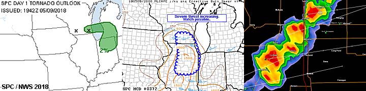
7). May 9, 4:30 PM - Interception and penetration of strong to possibly severe thunderstorms in Livingston and La Salle Counties, Illinois and near SR 23 and 179 from SW of Streator and west of Dana. The storm was a multicell cluster of strong to marginally severe thunderstorms. Frequent lightning, heavy rains, small hail (less than pea sized), and winds gusting near 60 MPH were observed. The storm also kicked up dust with passage of the gust front. The storm continued east and northeast, eventually forming a line, and causing minor wind damage in the Chicago area (I did not, and it's basically impossible to, follow the storm into the metro areas during rush hour). The storm was caused by surface heading, a weak cold front, low pressure trough, and an upper trough. A 2016 Jeep Wrangler was used to chase the storms. Documentation was digital stills.
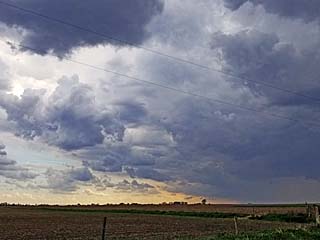
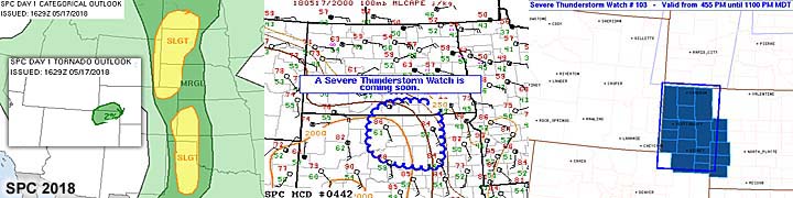
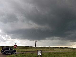
8). May 17, 5:30 PM - Observation of strong thunderstorms to the west and northwest of Fort Morgan, Colorado near I-76 and SR 144 near Morgan County. The storms were high based multicell storms. Light rain, frequent lightning, and winds near 50 MPH kicking up dust was observed. The main cores were not penetrated directly. Some gustnadoes were also observed. The storms were caused by surface heating, upslope wind flow, convergence (associated with the DCVZ / Denver cyclone and lee trough), and an upper trough. A 2016 Jeep Wrangler was used to chase the storms. Documentation was digital stills. A severe thunderstorm watch was valid just north of this area until 11 PM MDT.
9). May 18, 7:30 PM - Observation of a very severe thunderstorm to the northwest of Scott City over Logan County, Kansas near Russell Springs and west of Highway 83. The storm was an LP supercell storm that evolved to a classic supercell and finally a line segment as other storm cells to the south cutoff the inflow to it. The core was not penetrated (had 2" hail). The storm had a striking visual appearance with striations and inflow tails. From my vantage point, 40 MPH winds, light rain, and frequent lightning was observed. The storm remained over open country during much of its life. The storm was caused by surface heating, a low pressure area, dryline, stationary front (triple point), and an upper trough. A 2016 Jeep Wrangler was used to chase the storms. Documentation was HD video and digital stills. A severe thunderstorm watch was valid just north of this area until 11 PM CDT.
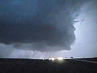
10). May 18, 9:00 PM - Interception and penetration of a very severe thunderstorm near Gove and Sheridan Counties, Kansas along I-70 east of Oakley and west of Grainfield. The storm was a powerful supercell that evolved from classic to HP mode. The storm was very difficult to reach on time due to a massive traffic jam on I-70 thanks to dozens of foolish drivers seeking shelter under the Gove 24 overpass and blocking all lanes illegally. Large hail to 2" was observed in this area, with 60 MPH winds, extremely heavy rains, and frequent lightning with some close hits. A rotating area was encountered near Grainfield with a low base and wall cloud / small funnels in twilight. Gusty shifting winds were encountered in this region. The storm had a striking visual appearance as an HP storm when viewed from the east near Quinter. Baseball sized hail was also reported (2.75") with this storm. The storm was caused by surface heating, a low pressure area, retreating dryline, stationary front / outflow boundary, and an upper trough. A 2016 Jeep Wrangler was used to chase the storms. Documentation was HD video, audio, and digital stills. A severe thunderstorm watch was valid just north of this area until 11 PM CDT.
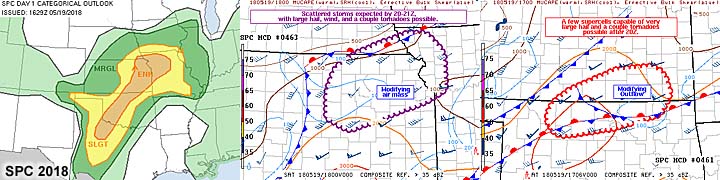
11). May 19, 4:30 PM - Interception and indirect penetration of severe thunderstorms from near Independence, Kansas through Oswego in Montgomery and Labette Counties along Highway 160 and farther east into Missouri. The storm began as a supercell storm near Washington County, Oklahoma, with a possible tornado (not observed), before moving northeastward into Kansas. The storm was not observed at that point, and this was a long range intercept. The storm evolved to a multicell cluster and when it was reached, had 60 MPH winds, small hail, frequent lightning with close hits, and very heavy rains. The storms evolved to a loosely organized MCS that moved across much of Missouri and making the drive along I-44 (from near Springfield, Missouri to Sullivan) very unpleasant. The storms were caused by surface heating, a low pressure area, prefrontal convergence, and an upper trough. A 2016 Jeep Wrangler was used to chase the storms. Documentation was digital stills. A severe thunderstorm watch was valid just north of this area until 10 PM CDT.
12). May 25, 4:30 PM - Interception and indirect penetration of strong to severe thunderstorms near Tama, Iowa in Tama County and near Highways 30 and 63. The storm was a weakening multicell cluster of strong and severe thunderstorms. The weakening core was penetrated before having a flat tire and having to change it at a gas station south of Tama off 63. Small hail, 50 MPH winds, frequent lightning, and heavy rains were observed. The storms were caused by surface heating, a low pressure trough, and a weak upper trough. A 2016 Jeep Wrangler was used to chase the storms. Documentation was digital stills. A severe thunderstorm watch was valid just north of this area until 10 PM CDT.
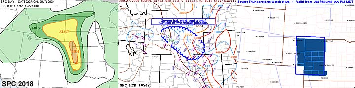
13). May 27, 6:00 PM - Interception and indirect penetration of severe thunderstorms near and south of Roscoe and Ogallala, Nebraska in Kieth County and near Highway 30 / SR 61 and south of I-80. The storm was a cluster of severe thunderstorms, with a supercell storm for a short while. Hail to 3/4", 60 MPH winds, frequent lightning, and heavy rains were observed. The storms were caused by surface heating, a low pressure trough, and a weak upper trough. A 2016 Jeep Wrangler was used to chase the storms. Documentation was digital stills. A severe thunderstorm watch was valid just north of this area until 9 PM CDT.
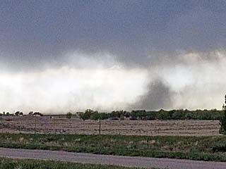
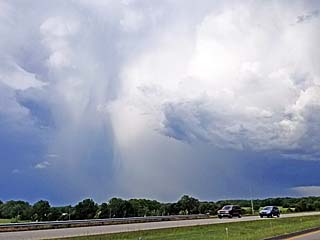
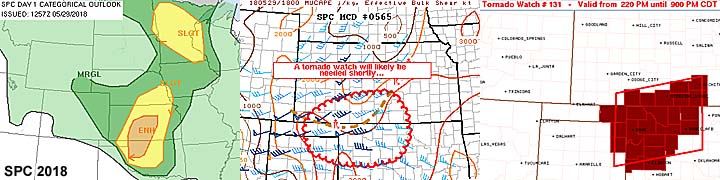
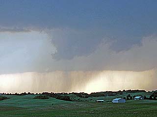
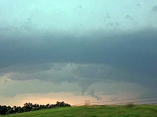
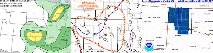
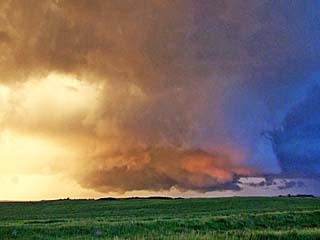
14). May 28, 6:00 PM - Observation and indirect penetration of extremely severe thunderstorms in Kit Carson County, Colorado between I-70 and Highway 36 and north of Seibert. The storms were a complex interaction of a supercell storm and flanking line extending along a surface boundary, with at least a dozen tornadoes produced during a period of less than 2 hours! The entire life cycle of these storms were documented, from initiation to weakening / evolution to a squall line. These tornadoes were landspout type tornadoes, however, some were quite large with stove pipe dimensions, similar to that seen in Wray, CO in May 2016. The tornadoes at one point were multiple, with two (or even three) on the ground at the same time. Two large stove-pipe landspouts (highly visible and photogenic) were observed north of Seibert, with one rotating counter clockwise and the other anti-cyclonic and rotating clockwise, with intermittent quarter to golfball sized hail falling in a near rain free environment. Besides the tornadoes, hail up to golfball sized was observed, along with frequent lightning, heavy rains, and 60 MPH winds. The supercell storm also had a striking visual appearance and complex structure. The only damage observed was downed powerlines along a farm road from one of the tornadoes. Farther east, the storms were sampled again as a squall line west of Burlington, Colorado. Conditions causing the storms were surface heating, upslope wind flow, a low pressure area, upper trough, and complex surface boundary interactions. A 2016 Jeep Wrangler was used to chase the storms. Documentation was digital stills and HD video. A tornado watch was also valid until 9 PM MDT (10 PM CDT) for the area.
15). May 29, 5:30 PM - Observation and indirect penetration of an extremely severe and tornadic thunderstorm from Highway 64 and Highways 183 / 34 in Selman, Oklahoma in Harper County and eastwards to near Waynoka and Highway 281 in Woods County, Oklahoma. The storm was a long track supercell storm, and most of its life cycle was documented from point of initiation and eventually down-scaling eastward. It started out as classic then evolved to an HP supercell. The mail core (with tennis to baseball sized hail) was not penetrated during its intense phases. As the storm weakened, 1" to 1.5" hail was noted with frequent lightning, 60 MPH winds, and very heavy rains. Two brief tornadoes were observed with this storm near Waynoka, Oklahoma. One was a thin brief rope, with a brief cone tornado to its southwest as the storm cycled. During the earlier stages of the storm, a striking visual appearance was presented, with rapidly rotating wall cloud and funnels, and intense stream-wise vorticity issuing into the NE side of the storm updraft. Damage from this storm was minimal in Waknoka from the small tornadoes there. Conditions causing this storm were a triple point (dryline and outflow boundary interaction), a low pressure area, surface heating, and an upper trough. A 2016 Jeep Wrangler was used to chase the storms. Documentation was HD video, audio, and digital stills. A tornado watch was also in effect for the area until 9 PM CDT.
16). May 29, 9:30 PM - Penetration of a severe thunderstorm along Highway 412 in Woodward County, OK and near Mooreland. The storm was a weakening severe storm on the backside of a cluster of strong and severe thunderstorms. Conditions encountered while passing through the storm were very heavy rain, frequent lightning, 1" hail, and 60 MPH wind gusts. Conditions causing the storms were surface heating, a low pressure trough, low level convergence / retreating dryline, and an upper trough. A 2016 Jeep Wrangler was used to chase the storms.
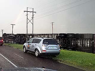
17). May 30, 7:30 PM - Interception and penetration of extremely severe thunderstorms from near Clayton and Sedan in northeastern New Mexico by SR 102 and 402 in Union County and ultimately through Spearman, Texas in Hansford County near SR 15. The storm was a combination of a line segment with an LP storm on its southern side, which split and down scaled. The left split evolved to a powerful HP supercell storm and moved east into the Texas Panhandle, then evolved to a destructive wind event / bow segment. This supercell storm had hail at least tennis ball sized, and was noted along side of Highway 54 northeast of Startford with a semi truck overturned. As the storm moved east and evolved to an HP storm / line segment, winds eventually gusted near 80 MPH with power out and poles down across SR 15. The storm also contained extremely frequent lightning and torrential rains. The storm also caused wind and hail damage. The storms were caused by surface heating, a low pressure area, dryline / boundary interactions, and an upper trough. A 2016 Jeep Wrangler was used to chase the storms. Documentation was digital stills and HD video. Two severe thunderstorm watches were valid for these areas, one until 10 PM CDT and the other farther east until 5 AM CDT the following day.
18). June 1, 5:30 PM - Observation and indirect penetration of severe thunderstorms from near Wood Lake to Ainsworth in Brown County, Nebraska and near Highway 20 and 183. The storm was a supercell storm that evolved to HP, then a line segment / cluster of severe thunderstorms. A large wall cloud was noted on the HP storm before it became rain hidden. The core (with hail up to 2.5") was not directly penetrated, but hail up to 1.5" was noted with frequent lightning, heavy rains, and 50 MPH winds. The storms were caused by surface heating, a low pressure area / trough, Pacific cold front / boundary interactions, and an upper trough. A 2016 Jeep Wrangler was used to chase the storms. Documentation was digital stills and HD video. A tornado watch was also in effect for the area until 11 PM CDT.
19). June 1, 8:00 PM - Observation and indirect penetration of severe thunderstorms from near Taylor and points eastward towards Burwell in Loup and Wheeler Counties, Nebraska and east of 183 and near SR 91 / 11. The storm was an LP supercell storm that down-scaled then cycled back up to an HP storm, and ultimately a line segment. The storm spawned a couple of funnels, plus a possible brief tornado viewed from the east later on near Highway 281 (probably looking towards Ord, Nebraska). During the indirect brush with the storm core, 1" hail, frequent lightning, 50 MPH winds, and moderate rains were encountered. The storms were caused by surface heating, a low pressure trough, Pacific cold front, and an upper trough. A 2016 Jeep Wrangler was used to chase the storms. Documentation was digital stills and HD video. A tornado watch was also in effect for the area until 11 PM CDT.
20). June 11, 5:00 PM - Interception, observation, and indirect penetration of a very severe and possibly tornadic thunderstorm near Highways 77 and 275 in Dodge County, Kansas near Nickerson and from Snyder to Fremont. The storm was a supercell storm that was observed from initiation and evolved from classic to HP before being undercut by a surging cold front. The storm developed along a SE to NW oriented boundary / confluence axis. A possible brief tornado was observed before rain wrap and an rapidly rotating wall cloud to the northwest of Fremont, Nebraska. This storm had a striking "stacked plates" visual appearance. The storm also contained very large hail, 60 MPH winds, heavy rains, and frequent lightning with some close hits. Hail from 1" to 1.5" was noted north of Fremont during the tornadic phase of the storm before it was undercut. The storms were caused by surface heating, a low pressure area, Pacific cold front / boundary interactions, and an upper trough. A 2016 Jeep Wrangler was used to chase the storms. Documentation was digital stills, audio, and HD video. A tornado watch was also in effect for the area until 11 PM CDT.
21). June 11, 7:00 PM - Interception and indirect penetration of a very severe and tornadic thunderstorm in Cass County, Nebraska along Highway 75 near Murray. I arrived late on this storm during its HP phase, and observed a large wall cloud north of Murray before it became undercut by the surging cold front and evolved to an intense line segment. The storm produced a brief tornado earlier, which quite possibly was noted while 20 miles away from the storm looking towards the SSE from southwest of Omaha. The storm was penetrated from the northeast side, and small hail, 60 to 70 MPH wind gusts, heavy rains, and frequent lightning was noted. The storm evolved to a line segment / cluster and had a striking visual appearance, even after it became undercut with strong outflow. The storms were caused by surface heating, a low pressure area, Pacific cold front / boundary interactions, and an upper trough. A 2016 Jeep Wrangler was used to chase the storms. Documentation was digital stills, audio, and HD video. A tornado watch was also in effect for the area until 11 PM CDT.
22). June 12, 7:30 PM - Interception, observation, and penetration of a severe thunderstorms near Laverne and Buffalo, Oklahoma west of Highway 183 and along Highway 64 in Harper County. The storm was an HP supercell storm. Some rotation was noted on the south / inflow side of the storm, with some small funnels observed. The storm also contained large hail (with pieces 1.25" observed), very heavy rains, frequent lightning, and 60 to 70 MPH winds. Some tree damage and power poles were blown down, blocking a portion of Highway 64. The storms were caused by surface heating, a low pressure trough, outflow boundary / stationary front interactions, and an upper trough. A 2016 Jeep Wrangler was used to chase the storms. Documentation was digital stills. A severe thunderstorm watch was also in effect for the area until 11 PM CDT.
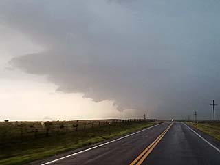
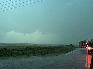
23). June 13, 7:30 PM - Interception and penetration of a severe thunderstorm near Yuma, Colorado in Yuma County near SR 59 and Highway 34. The storm was a transient supercell storm / multicell cluster with a high base. Large hail to 1" or 1.25" was noted east of Yuma on Highway 34. The storm also had 60 MPH winds, heavy rains, and occasional lightning. The storms were caused by surface heating, upslope wind flow, a low pressure trough, stationary front, and an upper trough. A 2016 Jeep Wrangler was used to chase the storms. Documentation was digital stills.
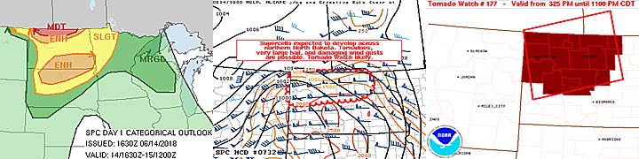
24). June 14, 7:30 PM - Observation and indirect penetration of a very severe and possibly tornadic thunderstorm from near Tolley in Renville County, North Dakota and eastward along SR 5 and 17 to near Cando in Towner County. The storm was a long track supercell storm that developed on the southern tip of a severe thunderstorm complex moving across southern Canada and near the US / Canadian border. The storm was HP / classic at times, and a powerful area of rotation and possible brief tornado was observed with this storm northwest of Willow City. The storm also contained very large hail, but the core was not directly penetrated. Hail up to 2" was observed, along with heavy rains, frequent lightning with close hits, and 60+ MPH winds. The storm was caused by surface heating, a low pressure area, approaching Pacific cold front (prefrontal), and an upper trough. A 2016 Jeep Wrangler was used to chase the storms. Documentation was HD video, audio, and digital stills. A tornado watch was also in effect for the area until 11 PM CDT.
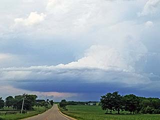
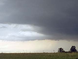
25). June 15, 4:30 PM - Interception and observation of a strong to severe thunderstorm near Wheeler, Wisconsin and over Dunn / Chippewa Counties to the north of I-94 and west of Highway 53 near SR 64. The storm was a classic to even LP supercell storm, with a moderately high base but striking visual appearance (stacked plates or "mothership" effect). The storm was tornado warned but did not produce and confirmed tornadoes. The base was rather high but an RFD clear slot was noted and small wall cloud briefly formed. The storm core was not directly penetrated, and winds near 40 MPH, lightning, moderate to heavy rain, and small hail was encountered. The storm was caused by surface heating, a low pressure trough, warm front, and an upper trough. A 2016 Jeep Wrangler was used to chase the storms. Documentation was digital stills.
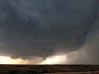
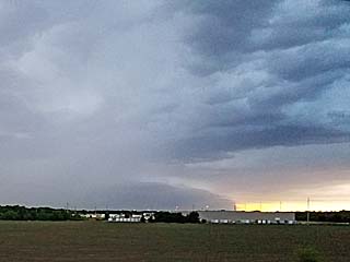
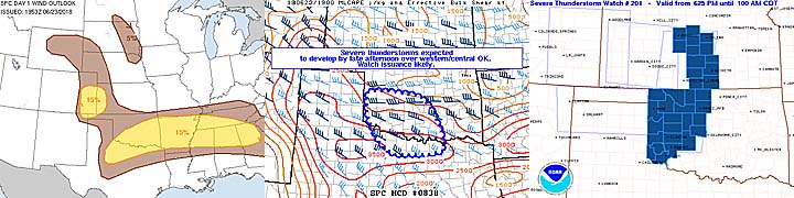
26). June 23, 8:30 PM - Interception and observation of a severe thunderstorm near and southeast of Snyder and Frederick, Oklahoma east of Highway 183 and north of SR 5, mainly in Kiowa County. The storm was a supercell storm (LP to classic) with a powerful updraft region viewed from the rear flank. The core of the storm was not penetrated, but contained 60 MPH winds, golfball sized hail, lightning, and moderate rains. Frequent lightning was also observed with this storm, which was part of a small severe thunderstorm cluster. The storm was caused by surface heating, a low pressure trough, outflow boundary, and an upper trough. A 2016 Jeep Wrangler was used to chase the storms. Documentation was digital stills. A severe thunderstorm watch was in effect for the area until 10 PM CDT.
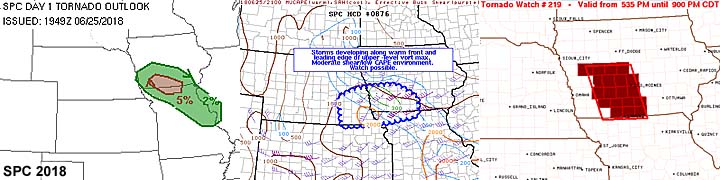
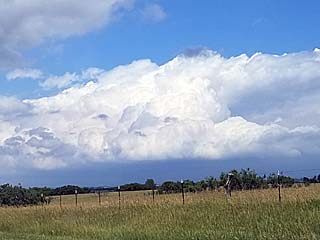
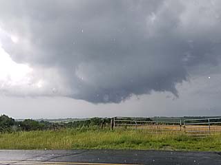
27). June 25, 6:00 PM - Observation and penetration of a strong to severe and possibly tornadic thunderstorm near Davis City and Leon, Iowa in Decatur County near Highway 69 and SR 2. The storm was a small classic supercell storm, low topped, and at one point had a rapidly rotating wall cloud and funnels. I was not able to confirm any ground circulation. The storm also contained heavy rains, small hail, and winds gusting 50 to 60 MPH. The storm formed earlier near Bethany in Harrison County, Missouri before intensifying and moving to the NNE. The storm was caused by surface heating, a low pressure area, warm front, and an upper level low. A 2016 Jeep Wrangler was used to chase the storms. Documentation was digital stills and HD video. A tornado watch was in effect for the area until 9 PM CDT.
This concludes the chase log for the central US Plains for the main chase "expedition" of 2018 starting April 28 and ending on June 25. The summary includes a total of 27 observations, out of which there were 26 severe thunderstorms and 1 strong thunderstorm. Out of these thunderstorms, at least 20 tornadoes were observed, with many of them during the landspout outbreak on Memorial Day (May 28). The main chase vehicle conducting this chase was a 2016 Jeep Wrangler. All entries for the logs above are for the local time zone unless otherwise noted. This information was prepared exclusively for the National Weather service and the team of Skywarn storm spotters.
|
Myself beginning the long drive out of Florida, and to the first stop for the night at chase partner / meteorologist Derek Sibley's place in Mobile, Alabama during the day of April 28, 2018. |
|
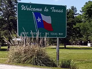
Entering Texas late in the day of April 29, 2018. |
|
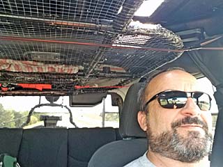
Another shot of myself driving, with the front and side hail grills conveniently stowed via packing straps in the Jeep's ceiling. |
|
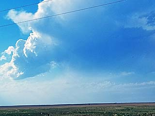
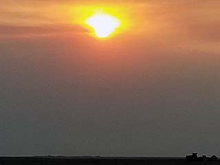
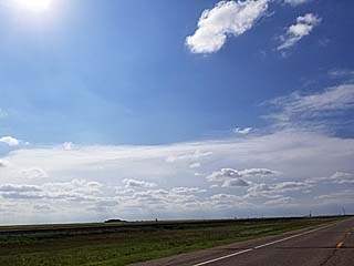
Rather benign looking sunset looking west from south-central Oklahoma late in the day on April 29. The first signs of the long awaited Pacific trough are denoted by distant high clouds appearing above the western sky as the sun sets. |
|
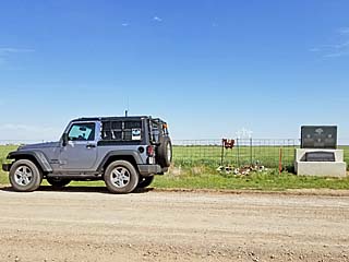
Visiting the Tim / Paul Samaras and Carl Young memorial near El Reno Oklahoma and by Radio / Reuter Roads during the morning of April 30, 2018. |
|
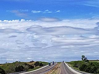
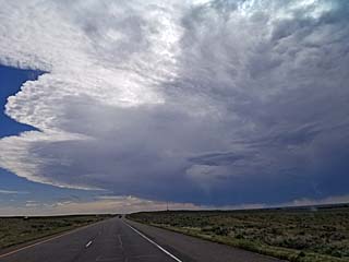
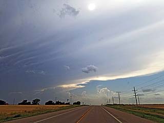
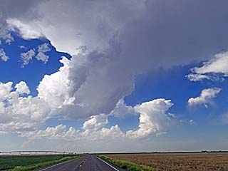
View of sky looking west on I-40 near the western OK / Texas border. Bizarre looking low clouds marks the low level moisture return (low level jet). The higher ACCAS (altocumulus castellanous) and other clouds denote the lead impulse / top of the EML (elevated mixed layer) and is typical of an early part of a chase day in the central USA. |
|
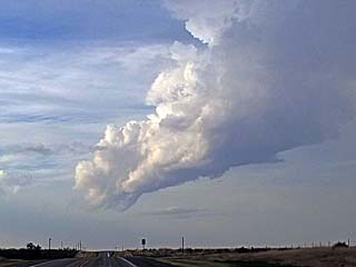
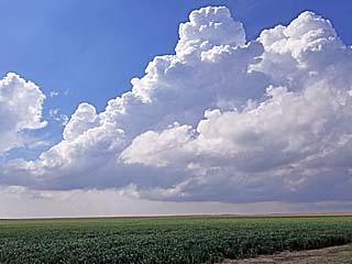
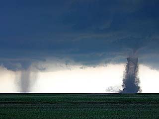
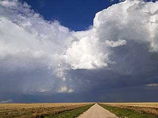
First small LP (low precipitation) supercell storm fires along the dryline over Collingsworth County, Texas by late afternoon. |
|
Another LP supercell storm trying to form near Memphis / Wellingon, Texas late on April 30. |
|
Another multicell cluster / supercell storm develops near Wellington, Texas. This storm split with the left mover becoming the more persistent storm as a fast moving LP. In this picture we see the left split (right) coming off the main storm. |
|
A wider view (to the NW) of the same storm above, with the right split raining out as a multicell line segment, and the left split (lower right portion of the photo) moving NNE. |
|
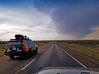
Fast moving left split LP storm nearing Shamrock, Texas, viewed from about 20 miles away as other chasers race north on Highway 83. |
|
The LP supercell storm undergoes downscale progression and basically shrinks to nothing north of Shamrock, Texas. Note the small high base funnel on the highly sheared supercell tower just above the roadway. |
|
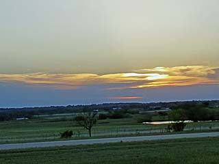
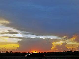
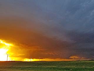
The "day before the day" chase day ends with this beautiful sunset as viewed from near Elk City, Oklahoma. |
|
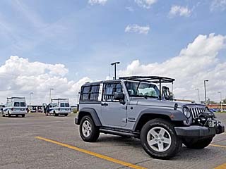
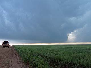
Preparing my vehicle, a 2016 Jeep Wrangler, for what is to be a major chase day near the target area on May 1, 2018 in Great Bend, Kansas. |
|
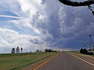
Convective initiation just west of Hays and Russell, Kansas. This is the start of what will be the first major tornadic supercell in the northern portions of the target area. |
|
The storm north of Russell, Kansas develops a wall cloud. |
|
Large wall cloud on the storm north of Russell, Kansas. |
|
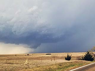
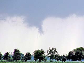
Rotating wall cloud crossing highway 281 north of Russell, Kansas. At this point, I decided to leave this storm as it was not looking very good after this "cycle". Attention turned to another supercell to the south near Otis, Kansas to the south. This original storm did later produce a large tornado near Concordia, Kansas. |
|
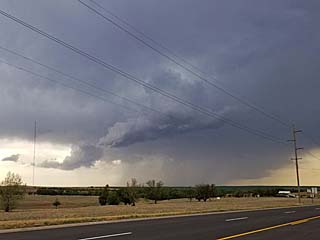
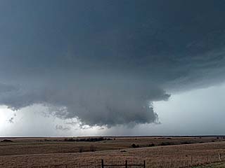
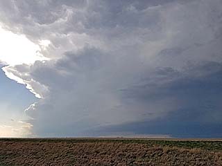
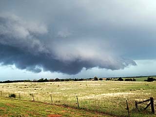
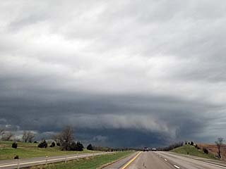
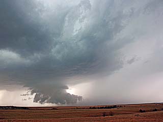
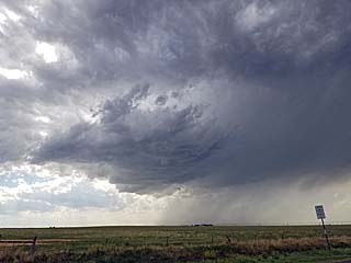
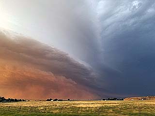
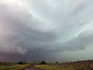
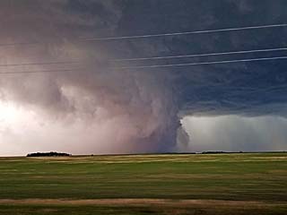
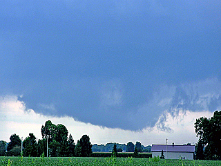
Rotating wall cloud and funnel (lower right side of photo). This is NW of Hoisington, Kansas along Highway 281 looking south and southeast. Extremely large hail, wrapping from left to right around the northern side of the wall cloud can also be seen in this picture. This will be a long-track cyclic supercell that later will produce multiple tornadoes. |
|
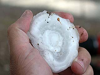
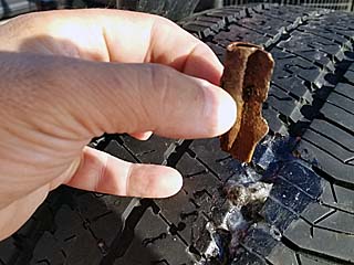
This is a broken hailstone picked up from the ground near a grain silo off NW 150 Road north of Hoisington, Kansas. The stone here is nearly 3 inches in diameter, and since it's fractured, the growth rings are prominent in this specimen. Each ring denotes a "roller coaster" ride up and down the supercell core, with vertical displacements exceeding 20,000 feet (until the updraft cannot keep it aloft anymore). Some stones exceeded 3 inches, approaching grapefruit sized. One stone hit the vehicle HAM radio antenna, mangling it and breaking the magnet mount base. Other stones hit with ear-ringing impacts. Fortunately, the hail guards obviously did their job and no windows were lost. |
|
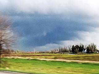
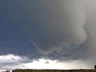
View of same cyclic supercell storm later on to the west of Ellsworth, Kansas. The storm weakened / cycled down, but still presented this beautiful view from 20 miles or so out. The storm will re-intensify as the low level jet increases in the evening. |
|
A weak tornado (rated EF-0) was spawned by the supercell storm as it began re-intensifying near the intersection of I-70 and SR 14 north of Ellsworth. This tornado was brief with a barely noticeable dust cloud beneath it, and did not last long. |
|
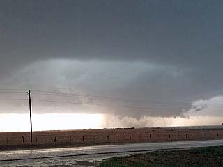
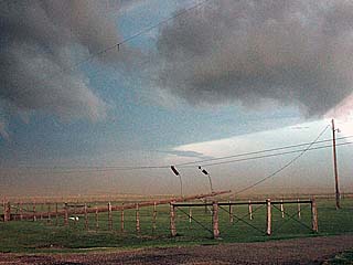
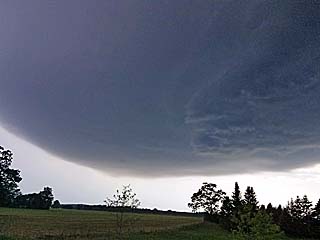
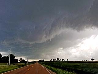
As the supercell moves north of I-70 and intensifies as the low level jet ramps up in the evening, a large "beaver's tail" can be seen extending eastward away from the storm updraft and along the FFD (forward flank downdraft) area. This is looking ENE along I-70 near Beverly, Kansas. The inflow band ("beaver's tail") is associated with the supercell interacting with a wind shear axis (stationary / warm front or outflow boundary) east of it. This "rotor" like area feeding into the storm is also known as the SCV (stream-wise vorticity current). |
|
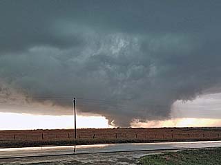
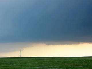
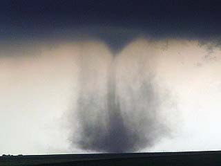
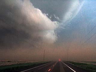
While stopped on the north side of Highway 18 and east of Tescott, Kansas and NW of Culver, tagging rain curtains give way to rotating dust and a lowered base to the south. This is the start of rapid tornado genesis. |
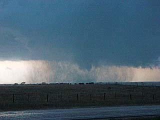
|
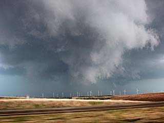
View of developing condensation funnel / internal vortex. Note the circulation, denoted by lots of dust, is far wider than the visible "funnel" extending down from the cloud base! |
|
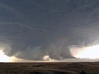
Wide view of developing tornado east and southeast of Tescott, Kansas. Note the RFD and circulation has worked its way completely around the tornadic circulation. |
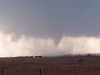
|
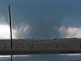
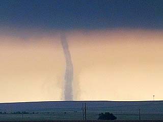
Cone tornado and expansive dust / debris cloud. |
|
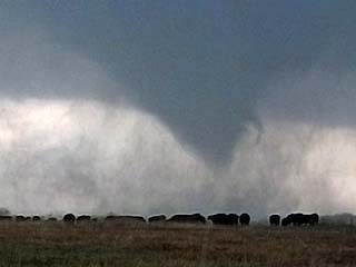
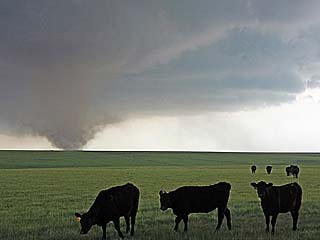
Closer view of the cone tornado and debris area. Note the cows in the foreground! |
|
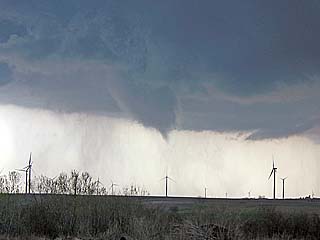
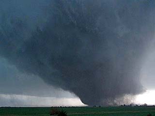
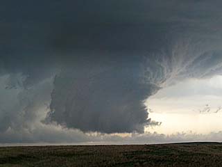
Tornado intensifying and widening to wedge phase (where it at least as wide as it is tall). |
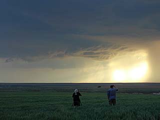
|
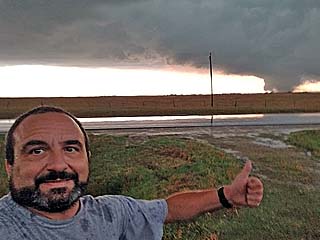
Myself taking a selfie and giving a thumbs up for a Facebook post as the tornado rages a mile or two to my south. |
|
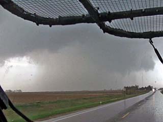
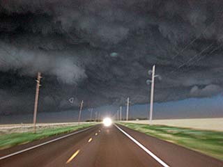
View of tornado in its wedge phase, and approaching my location before backing away a bit west on Highway 18. |
|
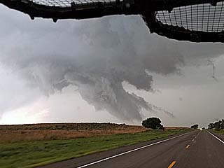
Tornado now less than a mile away, and approaching Highway 18. Loud roar was audible the entire time these pictures were taken. |
|
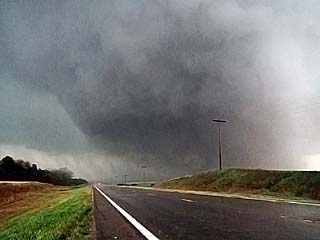
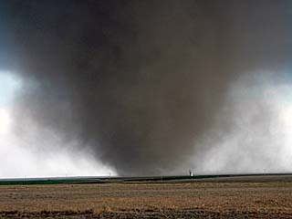
Wedge tornado now just about to cross Highway 18. Lour roar audible. Most of the power poles were taken down and some ground scouring. This tornado was rated EF-3 (with winds probably over 160 MPH), but fortunately did not hit any homes or structures. |
|
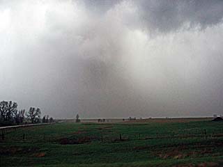
Tornado became highly rain wrapped and barely visible once north of Highway 18 and accelerating to the north SW of Minneapolis, KS as the storm occludes. Note the white color with brown dust suspended in the air. This is reminiscent of the end stages of the Stanton, NE tornado in June 2014. |
|
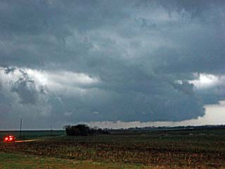
This is a view looking east from Highway 81 near Bennington. The storm is weakening but still has a rain-free base as it evolves to a bow segment. |
|
One "dent" in the front hail guard meshing after the May 1 storms. Had this not been on the vehicle, the windshield most likely would have been destroyed. |
|
Heading down famous Highway 183 through Coldwater, Kansas and to the target area in western to SW Oklahoma on May 2, 2018. Storms to the north in Kansas remained rather messy (disorganized) with more cellular storms farther to the south. |
|
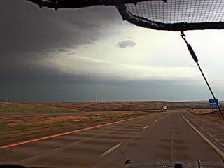
View of one of two supercells forming over SW Oklahoma near I-40 to the south as I was southwest of Woodward, Oklahoma and headed south on Highway 283. The plan was to dive south and come in from behind these storms after a data loss and navigation problems. |
|
Rotating wall cloud and funnel above the hilly areas of the Canadian River valley along Highway 152 near Binger, Oklahoma. |
|
Another view of the HP storm and wall cloud as it was splitting near Binger, Oklahoma. |
|
Southern split of the Binger, Oklahoma HP storm nearing Minco. The view is WSW but the storm is ingesting cooler air at the time. The wall cloud (lower left side of photo) is about to be undercut by the storm outflow to the right of it. |
|
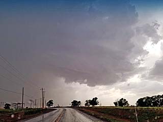
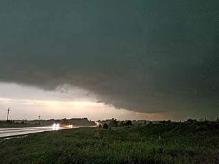
The HP storms undergo upscale progression and form a bowing line segment, which races east through Chickasha, Oklahoma and eventually through the south side of the Oklahoma City area. The view is to the north. |
|
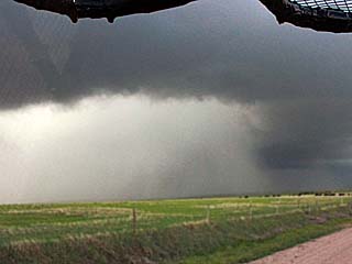
Heavy rain and strong winds strike the south side of Oklahoma City near Moore and Norman as the severe storms form a potent squall line. |
|
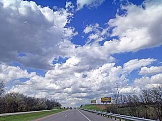
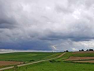
Storms initiating and agitated cumulus late in the day on May 3, 2018 near Craig, Missouri. This was just east of a surface low, where the warm front was the area of interest and target area. |
|
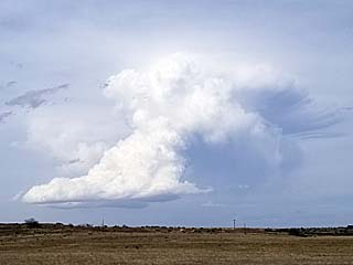
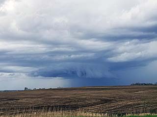
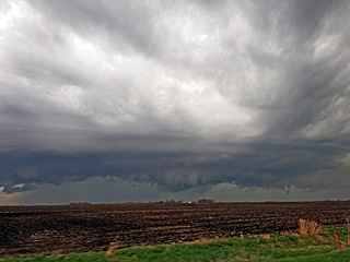
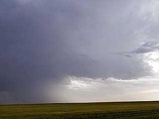
A small supercell forms along the apex of the warm / cold fonts and surface low near Tarkio, Missouri. This gently rotating storm produced this nice little wall cloud before evolving to a bow segment. |
|
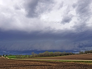
View of gust front and shelf cloud of an approaching line segment / bow near Bedford, Iowa. |
|
Another supercell storm develops near the warm front and ahead of the developing line segment to its west near New Virginia, Iowa looking north from I-35 and Highway 34. |
|
A funnel cloud develops under the storm updraft near New Virginia in this view looking to the NE. Ironically, this storm will produce a small tornado and be one of the only ones to be reported that day. |
|
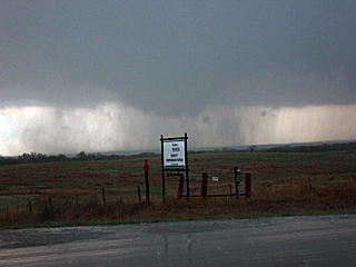
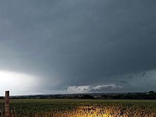
View of storm as it was tornado reported near Pleasantville, Iowa and south of Swan near SR 5. The wall cloud is associated with part of an HP storm along a line segment. The tornado, highly wrapped in rain, is barely visible just right of the center of the picture above the leftmost stand of trees. |
|
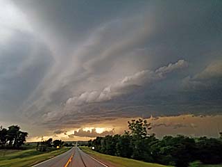
Beautiful multi-tiered shelf cloud pushing past Swan, Iowa and starting its long race eastward across most of the state over the next few hours. |
|
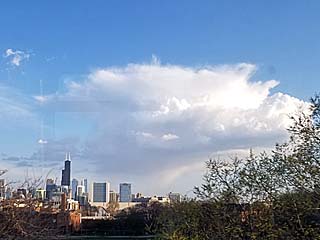
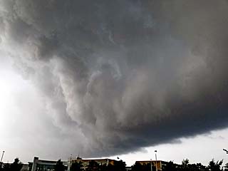
During off time in the Chicago area, a weak cumulonimbus cloud looms over the skyline as seen from a CTA train. |
|
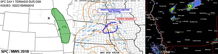
View of the shortwave trough axis passing over western Iowa late in the day on May 8, 2018 as the low levels remain capped. |
|
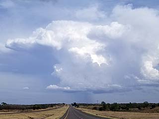
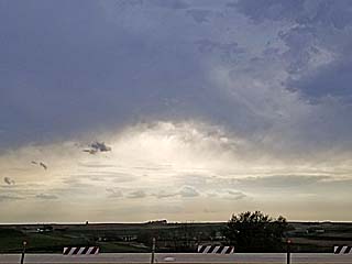
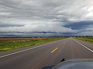
Approaching strong to severe thundrstorms near Streator, Illinois during the afternoon of May 9, 2018. |

|
Strong winds blowing across SR 23 south of Streator, Illinois and dust across farmland. |
|
View of dust being kicked up by the leading edge of thunderstorm outflow from a storm near Dana, Illinois. |

|
Making repairs to damage on top of the chase vehicle from the May 1 hailstorm north of Hoisington, Kansas. Here the roof is being sealed with epoxy and the damage will be smoothed over and re-painted. The antenna (hit by the 4" piece of hail and knocked into the Jeep top doing the damage) was also repaired. This was done during off time between chase trips in the Chicago suburbs. |
|
Distant non severe storms looming over the horizon while driving west on I-80 in central Nebraska on May 16, 2018. The view is to the north. |
|
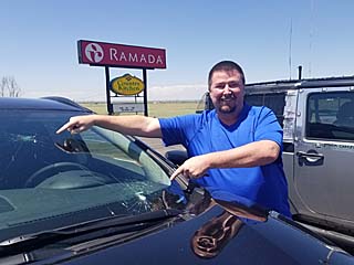
Mark Farmer showing hail damage to his windshield in Sterling, Colorado before chasing on May 17, 2018. |
|
High based convection developing east of the front range in upslope wind flow late on May 17. |
|
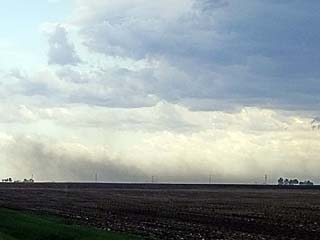
Strong dry microburst winds create some blowing dust under the high-based storms as well as small gustnadoes. |
|
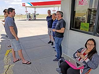
Chaser convergence near Tribune, Kansas on May 18, 2018 while waiting for storms to develop. Jason Persoff, Rocky Rascovich, and Chris Kridler were among those at this gas station. |
|
Convective initiation near the outflow boundary / dryline "triple point" to the northwest of Scott City, Kansas late in the day on May 18. |
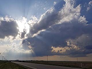
|
Same view as above, about 30 minutes later, and explosive development of an LP supercell storm. Note the crepuscular rays! |
|
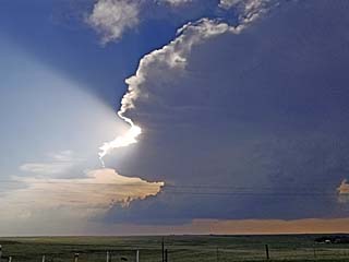
Another view of the LP storm northwest of Scott City, Kansas and south of Russell Springs showing the rain free base and updraft structure. |
|
View of rotating portion of the LP supercell west of Highway 83 and south of Russell Springs, Kansas. After this, the storm encountered less favorable inflow from other storms developing to the southeast. |
|
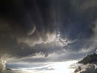
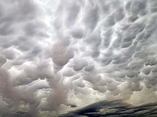
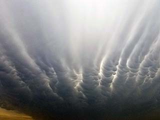
Mammatus clouds south of Oakley, Kansas with crepuscular rays. |
|
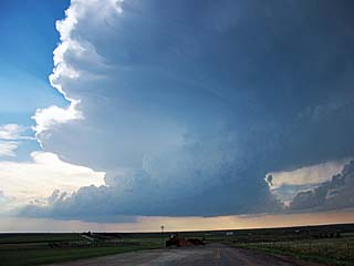
View of another supercell storm looking eastward on I-70 east of Oakley, Kansas as it was evolving to HP mode. Note the flaking line from right to left, and hail region on the left portion of the photo. |
|
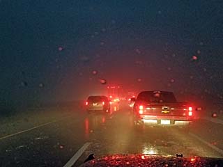
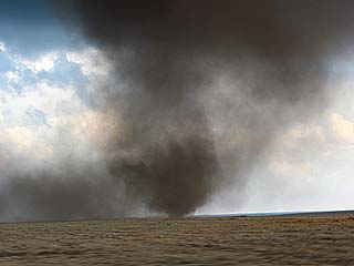
A massive traffic jam nearly a mile long was created by many people parking under an overpass near the storm, seeking refuge from hail (up to baseball sized) between Oakley and Grainfield / Quinter. This is very foolish blocking the ENTIRE roadway because it hampers emergency vehicles. In this picture, hail is falling with 60 MPH winds, and an eerie hail fog blows by. |
|
This is the view of the updraft region of the HP supercell storm, with a powerful low level mesocyclone, illuminated by lightning. The view is looking WNW from near Collyer, Kansas just off I-70. |
|
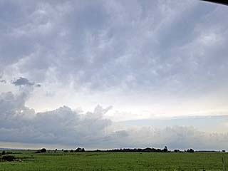
Anvil and blowoff extending to the northeast out of a powerful supercell storm (evolving to an MCS) near Sedan, Kansas on May 19, 2018. Storms developed early in the day in less than favorable conditions. |
|
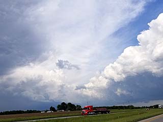
View of forward propagating MSC pushing eastward over southwestern Missouri late in the day on May 19. The gust front and "arcus" cloud extends out of the thunderstorm complex to the left. |
|
View of hail shaft with the multicell storms racing eastward over SW Missouri. |
|
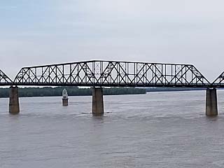
View of Mississippi River from the Chain of Rocks Bridge (I-270) looking south towards Saint Louis while making the trip back to Chicago on May 20, 2018. |
|
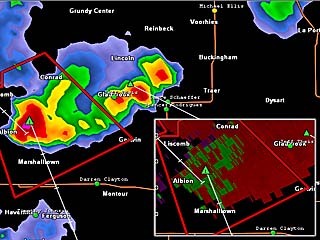
Some marginally severe storms to the northeast of Des Moines and east of Cedar Rapids, Iowa. The intense storm with a supercell structure shows up on the base reflectivity (note hail core) and slight velocity in the inset to the lower right. This was during the evening of May 25, 2018. |
|
Visual appearance of the supercell storm approaching Tama, Iowa from near Merengo. Note the hail core to the right. The view is to the west. |
|
Huge piece of metal pulled out of my tire after turning around on a small road near Tama, Iowa. This emptied the tire flat in seconds. In the picture I have put a large plug in the tire and the metal piece is shown after taking it out. |
|
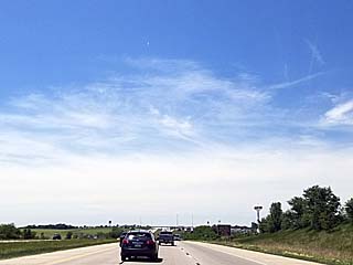
Heading west on I-80 and into Nebraska while on a long road trip from the Chicago suburbs to southwestern Nebraska on May 27, 2018. Note the clear sky giving way to high clouds in the western sky as the next round of upper level support reaches the western USA from the Pacific. |
|
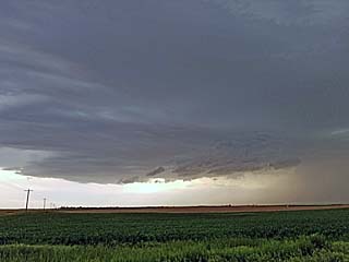
A small supercell storm south of Ogallala, Nebraska with striations and rain free base. This was a far cry from tornadic storms that unexpectedly developed farther away near Cheyenne, Wyoming. |
|
Mammatus on the backside of the storms near Ogallala, Nebraska during the early evening. |
|
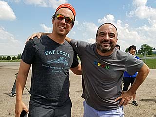
Myself and Reed Timmer (left) at a chaser convergence before convective initiation near Flagler, Colorado during the afternoon of May 28, 2018. |
|
Storms initiating along a confluence boundary and north of Flagler, Colorado during the afternoon. This will become a supercell storm. |
|
Supercell storm in Kit Carson County, Colorado near Highway 36 and north of Seibert. |
|
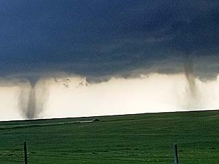
One of the first of many landspout tornadoes developing north of Seibert, Colorado in Kit Carson County. |
|
Closer view of one of the first landspout tornadoes. |
|
Twin landspouts developing north of Seibert, Colorado in Kit Carson County. |
|
Close up of one of the twin landspouts north of Seibert, Colorado in Kit Carson County. |
|
Another view of the two landspout tornadoes a bit later north of Seibert, Colorado in Kit Carson County. |
|
Close range shot of northern landspout tornado core region. This was anticyclonic, rotating clockwise, and rare for the northern hemisphere. |
|
In addition to the two large landspout / stove pipe tornadoes ... Yet a third one forms south of them! In this view, looking south, a weaker third landspout can be seen distant and just above and slightly left of the roadway, with the "twins" still on-going to the left! |
|
Close range shot of northern landspout tornado core region. This was anti-cyclonic, rotating clockwise. |
|
Southern landspout tornado over an field, weakening, with cows in the foreground. |
|
A final brief tornado, barely visble as a white cone through the RFD precipitation and near the center of this picture, is produced by a supercell storm the developed at the southern end of the complex of severe storms (formerly the ones that produced the multiple landspouts). |
|
Linear MCS of strong and severe storms developing west of Burlington, Colorado. The view is looking west on I-70. Note the green hue as well as scud tags to the left. |
|
Marble sized hail in the parking lot at a hotel in Goodland, Kansas as the linear MCS of strong and severe storms pushes through. |
|
Convective initiation near the surface "triple point" in northwestern Oklahoma near Laverne. This area will develop into a long track supercell storm during the afternoon of May 29, 2018. |
|
Rapidly intensifying supercell storm between Laverne and Buffalo, Oklahoma as the storm moves to the east. |
|
Wall cloud developing on the supercell storm as it passes southwest of Buffalo, Oklahoma. |
|
Maturing supercell with well developed RFD and wall cloud south of Buffalo, Oklahoma. |
|
Rapidly rotating wall cloud and influx of streamwise vorticity current (SVC). The horizontal "rotor" is being lifted by the leading edge of the supercell updraft and tilted into the vertical axis. |
|
Wall cloud as the HP storm occludes near Buffalo, Oklahoma. |
|
The supercell storm intensifies and produces a brief thin rope tornado near Waynoka, Oklahoma near dusk. |
|
Brief cone tornado develops over Waynoka, Oklahoma slightly southwest to where the weak rope tornado lifted. |
|
Hail and strong winds with very heavy rains to the northwest of Enid, Oklahoma as the supercell storm winds down and evolves to a line segment after dark. |
|
One of the first storms of the day developing in eastern New Mexico near Clayton. This is an LP storm during the afternoon of May 30, 2018. |
|
The LP supercell storm above undergone down-scaling and basically shriveled up into this high-based corkscrewed cumulus tower before evaporating as the northern split moves into better moisture in Texas. |
|
Rapidly developing HP supercell (the view is to the northeast) west of Stratford, Texas. |
|
Interesting split from the main tower and rotating portion of the developing HP supercell storm. This area will detach and weaken as moisture is limited behind the moisture axis and main storm. Note the prominent hail shaft (center of picture)! |
|
Another view of the split and backside of the main HP supercell storm. Interesting cloud formations overhead caused by turbulence on the backside of the storm complex. |
|
View looking north at an intense HP supercell storm near Stratford, Texas. Note the hail shaft to the left (hail up to tennis ball sized) and rainbow. |
|
Truck / trailer overturned from powerful RFD (rear flank downdraft) winds on Highway 54 northeast of Stratford, Texas. The driver was OK. Note the melting tennis ball sized hail on the ground to the right. |
|
Flanking line and inflow banding to the southeast of the HP supercell storm. The RFD is also kicking up a large dust plume / gustnado. |
|
HP supercell becoming outflow dominant with extreme damaging winds northwest of Spearman, Texas. Note the reddish "haboob" as the winds pick up the Texas dust. |
|
Powerful outflow winds / augmented RFD surging across SR 15 northeast of Spearman, Texas. |
|
Downed powerlines to the northeast of Spearman, Texas off SR 15. |
|
Impressive "whales mouth" and gust front as the HP storm evolves to a powerful MCS, with some wind gusts near 80 MPH. |
|
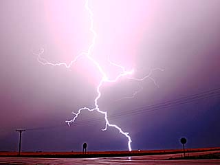
Nice lightning bolt near Gate, Oklahoma as storms approach from the west. |
|
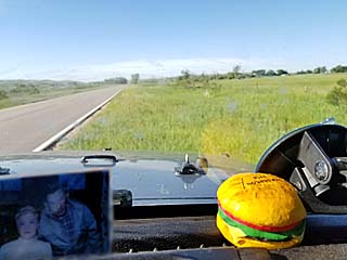
Driving through the Nebraska Sandhills late in the day on May 31, 2018. My good luck charm to the lower left (my grandparents) and remembering Tim and Paul Samaras with Carl Young (the cheesburger to the right) who were killed 5 years prior on May 31, 2013 in the El Reno Oklahoma tornado. In my other hand was a speeding ticket :( |
|
First supercell storm near Wood Lake, Nebraska after initiation and before evolving to a multicell / outflow dominant complex of storms during the afternoon of June 1, 2018. |
|
Storm chaser Scott Peake at a gas station in Taylor, Nebraska. |
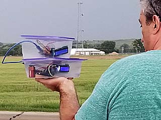
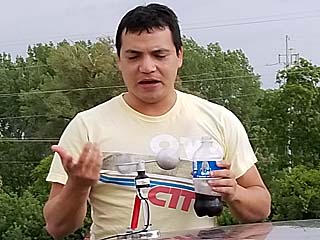
|
Storm chasers / scientists testing an interesting new prototype for a lightning detector while stopped in Taylor, Nebraska. |
|
Wall cloud on supercell storm northeast of Taylor, Nebraska. |
|
Funnel cloud on supercell storm northeast of Taylor, Nebraska. |
|
Looking west from Highway 281 at a funnel cloud (about the time a weak tornado was reported near Ord, Nebraska). |
|
Looking west at the "tail end" supercell storm of the line of severe thunderstorms after dark, with mammatus overhead and lightning. |
|
Crossing a cold front and some non-severe convection on June 2, 2018 and heading east on I-80 across central / eastern Iowa. |
|
Crossing Missouri river and into the target area near Blair, Nebraska during the afternoon of June 11, 2018 after a long drive from Chicago to start this "phase" of the main chase operations. |
|
First supercell storm developing near Nickerson, Nebraska on June 11. The view is to the WSW. |
|
Supercell storm moving to the southeast and rapidly intensifying and becoming tornadic near Snyder / Fremont, Nebraska. Note the hail falling in the foreground. The view is southwest. |
|
Weak tornado (tagging rain and dust) under the low level mesocyclone of the supercell storm near Fremont, Nebraska. |
|
HP supercell storm in Cass County in SE Nebraska late on June 11. This is looking towards the west and into the HP inflow "notch" of the storm. |
|
Low level mesocyclone passing just south of me along Highway 75 in Cass County, as it is undercut by the surging Pacific cold front. |
|
View of gust front and multi-tiered shelf clouds as the storm push southward towards the Kansas line in SE Nebraska. This was late evening on June 11, as storms evolved to a line segment with strong winds. The view is to the west. |
|
View of my chase vehicle with outflow dominant severe storm in the background at dusk on June 11. |
|
Coming across the College of Du Page (COD) chase group during a fuel stop near the Nebraska / Kansas border off Highway 75. |
|
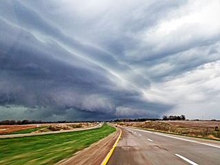
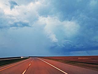
En-route to intercept a developing supercell storm between Coldwater, Kansas and Buffalo, Oklahoma during the late afternoon / early evening of June 12, 2018. The view is looking west (with anvil blowoff overhead) along Highway 54 / 400 near Greensburg, Kansas. |
|
Impressive rows of mammatus clouds on the anvil from a supercell storm over NW Oklahoma as I pass near Coldwater, Kansas during the evening of June 12. |
|
Inflow and updraft region of supercell storm to the west of Buffalo, Oklahoma as the storm follows a boundary and moves slowly to the west on June 12. The view is WSW. |
|
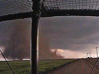
Brief funnel on the updraft side of the supercell storm to the west of Buffalo, Oklahoma as Highway 64 is blocked by wind damage and powerlines. The view is to the SW. |
|
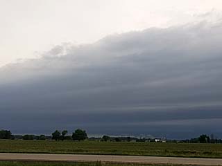
Linear mesoscale convective system while passing near Wakeeney, Kansas during the late moring of June 13, 2018. These are not the target storms, and are caused by warm advection that normally wanes by early afternoon. |
|
Highly sheared cumulus and small LP supercell updraft to the north of Holyoke, Colorado on June 13. |
|
Developing high based supercell storm near Yuma, Colorado on June 13. This storm would mainly produce large hail. |
|
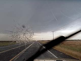
Hail up to 1" is falling near Yuma, Colorado during the evening of June 13. One piece strikes the windshield as this picture was taken. |
|
View of sun at low angle late in the day while heading north towards Julesburg, Colorado on June 13. Smoke from a forest / brush fire at mid levels and temperature inversion (cap!) gives the sun an interesting look. |
|
The first supercell storm of the day looms over the distant horizon as I pass near Bismark, North Dakota during the afternoon of June 14, 2018. This storm is 100 miles away or so, but is not the main target storm. The view is NNE. |
|
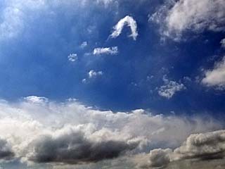
Agitated cumulus and horseshoe vortex as I pass north of Bismark later in the day on June 14. |
|
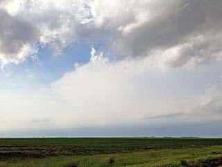
View of intense storm (and anvil) associated with main trough / front moving along the Canadian border from near Minot, North Dakota. This area will later produce the target supercells of the day. |
|
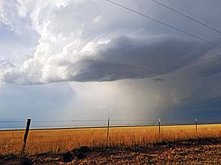
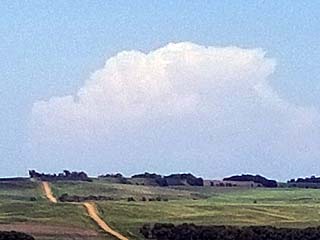
Supercell storm developing near Tolley, North Dakota. This will be the main target storm of the day (June 14). Note the little needle funnel on the wall cloud. The view is WNW. |
|
Looking at the supercell storm and updraft region over Towner County, North Dakota. The striking appearance of the hail core, with green glow, is prominent to the right in this picture, as the view is to the WSW. Crops were damaged from this storm, with hail between tennis ball and baseball sized. |
|
Rapidly rotating wall cloud / supercell "notch" and possible brief tornado over Towner County while heading east of the storm. The view is to the NNW. |
|
Inflow bands into the supercell storm near Towner County, North Dakota. The view is to the NNE. |
|
Diverting off the main state routes proved to be a dangerous and foolish mistake - With a gravel road giving way to a dirt road and then literally NO ROAD - Dumping me into a muddy corn field with no choice to keep going (with a developing tornado and hail up to tennis ball sized pelting me)! Having a 4x4 Jeep handled this well. |
|
Beautiful view of supercell storm to the west of Cando, North Dakota. The sun is still out but its nearly 10 PM CDT! |
|
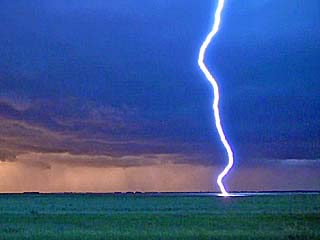
Loud and close cloud to ground lightning strike to the west of Cando, North Dakota near sunset on June 14. |
|
Final attempt of the supercell and low level mesocyclone wrapping up before being undercut again at dusk on June 14. |
|
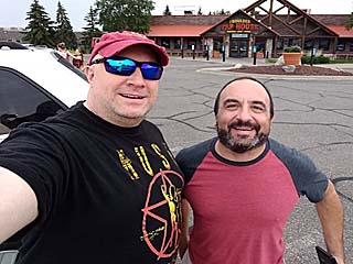
Myself and chaser Doug Kiesling (BNVN / StormChasing Videos) during lunch break in Saint Cloud, Minnesota on June 15, 2018. |
|
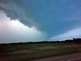
Approaching small supercell storm near Wheeler, Wisconsin from west of Eau Claire during the late afternoon of June 15. This storm was tornado warned (radar indicated) at the time. The view is to the north. |
|
RFD clear slot in supercell updraft base near Wheeler, Wisconsin. |
|
Visual appearance of the supercell near Wheeler, Wisconsin with a "mothership" appearance before it weakened via down-scaling late on June 15. |
|
Gust front from elevated storms slowly pushing south out of northern Wisconsin late in the day on June 15. |
|
Driving back from Wisconsin to Chicago via I-94 south on June 16 was not a fun trip, with road construction and major traffic delays. Of course, late in the day, a brief and weak tornado would form in Wisconsin, the only tornado to develop in the USA that day in an area not even outlooked! |
|
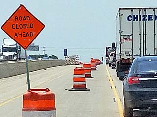
These are NOT the kind of "cones" a storm chaser wants to see! Once we move into June, road construction becomes a nightmare up north. |
|
While arriving in Wichita, Kansas ... Strong outflow kicks up dust (a haboob) looking northward during the evening of June 22, 2018 after a long drive from Illinois. |
|
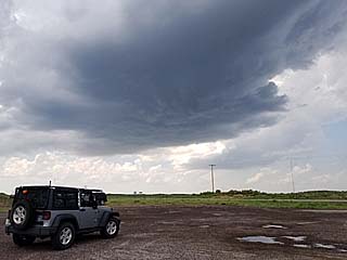
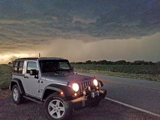
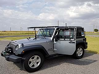
My vehicle with hair guards in place waiting for the capping inversion to erode on June 23, 2018 in SW Oklahoma. |
|
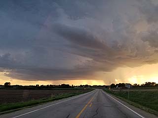
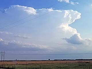
Small supercell storm developing late in the day on June 23 as the cap begins to erode. This was looking SW towards Willow, Oklahoma. |
|
A supercell storm develops farther southeast near Frederick and Altus, Oklahoma. |
|
Small wall cloud on flanking line of storm southeast of Altus. |
|
Looking up at the powerful updraft of the supercell storm between Snyder and Frederick. |
|
Laminar base of supercell updraft east of Frederick at dusk. |
|
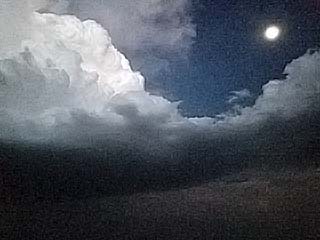
View of Frederick supercell downscaling with updraft, flanking line, and moon after dark. |
|
Gust front and outflow associated with expansive MCS (mesoscale convective system) early on June 24, 2018. This will essentially create a cool pool and cancel any chase prospects for the day. |
|
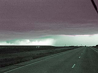
Capped atmosphere looking NW out of the northern Texas panhandle. Basically you get a sunburn instead of storms. The high clouds in the far horizon are from storms in south-central Colorado. |
|
Interesting cloud formations associated with upper level ascent and increasing low level jet (prior to severe MCS development) over south-central Kansas at dusk on June 24. |
|
Small supercell storm developing along warm front and east of occluding surface low in NW Missouri and towards SW Iowa on June 25, 2018. These are low topped storms. |
|
Intensifying storm northeast of Eagleville, Missouri with rotating wall cloud. Note the RFD cut to the left, and small funnel to the right. |
|
Large funnel (or possible weak tornado) during the late afternoon southeast of Leon, Iowa. The view is to the east and southeast. |
|
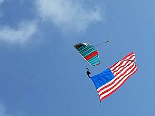
Some time was spend after chasing in the Chicago area, including the Independence Skydiving "Boogie" (event) at Rochelle, Illinois. Here a jumper flies the American flag on July 4 at Skydive CSC. |
|
A marginally severe storm looms over the Chicago suburbs on July 5, 2018. Two people were struck by lightning in Illinois from these storms. |
|
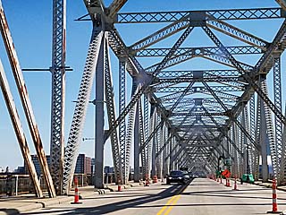
Crossing one of many bridges during the trip back to Florida on July 7-8. This is the old southbound bridge across the Ohio River and into Louisville. |
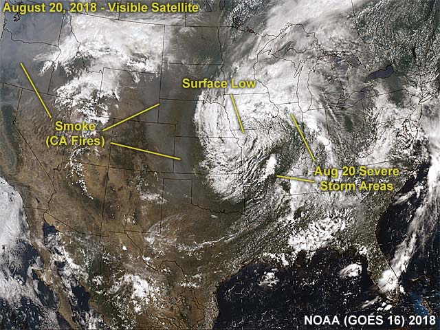
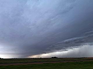
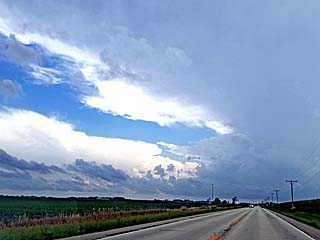
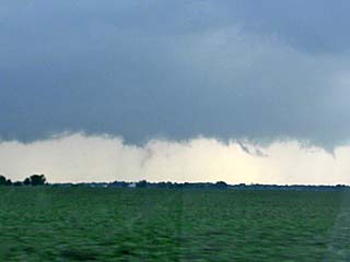
1). Aug 20, 5:30 PM - Interception and penetration of a strong to possibly severe thunderstorm in La Salle and Kendall Counties near Serena and Lisbon, Illinois and near Highways 71 and 52. The storm was a small supercell storm that developed in a cluster of strong thunderstorms, and evolved to HP and up scaled to a bow / line segment that pushed into Kane and Dupage Counties farther east. A rotating area with wall cloud and RFD clear slot was noted southeast of Newark. The wet RFD "hook" of this storm briefly produced 60 MPH winds and tree damage was noted on highway 52. The storm had a funnel cloud on its northern side that reached half way to the ground. The storm also contained lightning, small hail, and very heavy rains, in addition to winds over 50 MPH. A distinct wind shift (from SW to ENE) was noted penetrating the storm from SE to NW denoting a rain wrapped mesocyclone during its HP stages. The storm also had a striking visual appearance in its supercell mode. Conditions causing the storms were surface heating, a warm front, low pressure area, and upper trough. Documentation was HD video and digital stills. A friend accompanied me on this chase as an observer. A 2006 Scion was used to chase the storms.
This concludes the chase log for the central United States and Midwest for ANY OTHER chases in 2018 not part of a special section (especially those for single-day "spot" chase trips). The summary includes a total of 1 observation. Out of the observation, there was 1 severe thunderstorm. The main chase vehicle conducting these chases was a 2006 Scion. This information was prepared exclusively for the National Weather service and the team of Skywarn storm spotters.
|
View of sky and highly sheared cumulus tower looking towards the SW on I-88 and west of Aurora, Illinois on August 20, 2018. |
|
Anvil of target storm looking south towards Sandwich, IL on August 20 on Highway 23. The area of interest is just to the right of the road. |
|
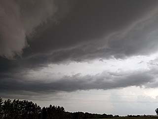
Interesting area of rotation associated with the shear axis of a NW to SE oriented warm frontal boundary and the northwest side of a small supercell storm west of Somonauk, IL on August 20. |
|
Close up of brief funnel cloud on the NW side of the storm complex west of Somonauk on August 20. |
|
View of wall cloud and developing new low level mesocyclone near Newark, IL while looking SE on August 20. |
|
Rotating wall cloud southeast of Newark, IL on August 20. |
|
View of rear flank downdraft southeast of Newark, IL on August 20 near Highway 52. The view is to the south with the rotating portion of the storm in the upper left and RFD / descending precipitation "blob" to the lower right. |
|
View of HP supercell storm undergoing upscale evolution to a bow / line segment near Yorkville, IL on August 20. The view is to the north. |
|
Backside view of gust front and "whale's mouth" as the line segment pushes east into the western Chicago suburbs near Aurora, IL late on August 20. |
HTML File "mwcl2018.htm" - Developed By Chris Collura
To Return To The HOME Page Of This Site Click The "INDEX.HTM" Link Here!