
| This section is for storm chases done in the central / Midwestern United States during the year of 2017. This includes all storm chasing activities (including any major chase "expeditions") during the year of 2017 in the central USA (aka "Tornado Alley"). For 2017, all chases in the central USA will be logged in this section, with many of the chases being possible "spot" chases / major severe weather "setups" chased. Here you should find many pictures of lightning, tornadoes, hail, strong winds, along with many severe thunderstorm elements. Keep in mind that this chase log is scientific evidence and portrays my on-going storm chasing research. It has been placed on this page for easy reference and meteorological interests. Please do not plagiarize or copy this document to other sites for distribution. Note - This page may take a while to load on some SLOWER connections! |
STORM CHASING - CENTRAL UNITED STATES - 2017 CHASE LOG
| CHASER NAME | HOME / BASE CITY | CALLSIGN | CHASE DATES | OCCUPATION |
| CHRIS COLLURA | DEERFIELD BEACH, FL | KG4PJN | 3-23 TO 3-30 | IT CONSULTANT |
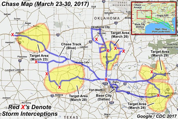
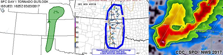
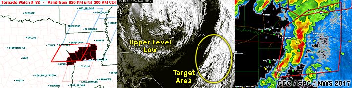
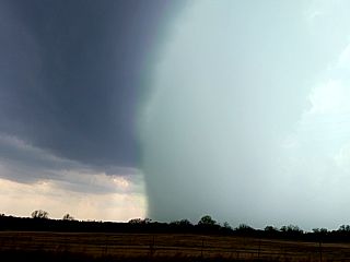
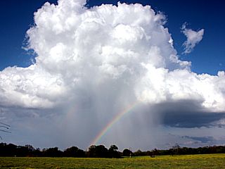
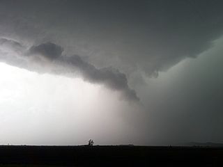
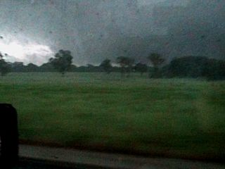
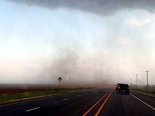
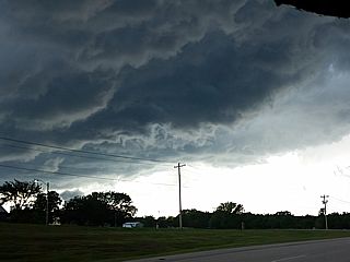
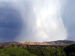
1). March 23, 6:30 PM - Interception and observation of a severe thunderstorm in Oldham / Potter County, Texas and west of Amarillo along Interstate 40. The storm was a supercell storm developing on the south side of a cluster of strong and severe thunderstorms. The core of the storm was not penetrated, but most likely contained large hail. Conditions encountered were occasional lightning, some rain, and strong winds gusting near 60 MPH. Dust was kicked up making it difficult to see the storm structure, but striations and the RFD clear slot was noticeable. Conditions causing the storm were a dryline, low pressure system, upper trough, and surface heating. A 2017 Hyundai Accent was used to chase the storms. Documentation was digital stills and HD video. A severe thunderstorm watch was valid for the area until 10 PM CDT.
2). March 24, 8:30 PM - Observation of a strong to possibly severe thunderstorm along I-20 and west of Marshall in Harrison County, Texas. The storm was a multicell segment of storms that acquired a pronounced bow structure after passing by. Very heavy rains, lightning, and winds near 45 MPH were encountered with this line segment. A possible tornado also developed in the northern portion of this bow segment from Marshall and northeastward. This would have been entirely rain wrapped and not visible in daylight anyway. Conditions causing the storm were a pacific front (overtaking a dryline), low pressure trough, upper trough, and surface heating. A 2017 Hyundai Accent was used to chase the storms. Documentation was digital stills and HD video. A tornado watch was valid for the area until 3 AM CDT the following day.
3). March 26, 1:00 PM - Observation of a strong to severe thunderstorm from Chickasha, Oklahoma in Grady County and near Highway 81. The storm was part of an elevated complex of strong and severe thunderstorms. Light to moderate rain, occasional lightning, and pea to dime sized hail was observed with this storm. Conditions causing the storms were a low level jet and strong upper trough. A 2017 Hyundai Accent was used to chase the storms. Documentation was digital stills.
4). March 26, 5:00 PM - Observation and penetration of a very severe and tornadic thunderstorm from near Tatums, Oklahoma to near Byars and Konawa, and in Garvin and McClain counties near Highways 19, 133, and 59. This storm was a classic supercell storm. The core was not directly penetrated but hail in excess 2" (most stones were smaller and quarter sized) was observed on the edge of the hail core, causing minor damage to the vehicle. An isolated hail stone to tennis ball sized was also noted smashing into the road. A low wall cloud and funnel was noted near Pauls Valley. A developing weak tornado was briefly visible with this storm south of Konawa looking northwest from Highway 3W. The storm also contained heavy rains, 50 MPH winds, and frequent lightning. Conditions causing the storm were a dryline, low pressure area, upper trough, and surface heating. A 2017 Hyundai Accent was used to chase the storms. Documentation was digital stills and HD video. A tornado watch was valid for the area until 11 PM CDT.
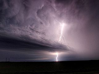
5). March 26, 7:00 PM - Observation of an extremely severe and tornadic thunderstorm to the east of Ada, Oklahoma in Ponotoc County near Highway 48 north of Lula. The storm was an LP to classic supercell thunderstorm. The storm had a striking visual appearance, appearing as a "spaceship" with striated updraft and vault, when viewed from the east. A well documented tornado was also observed with this storm as well north of Lula. The core of the storm was not penetrated, but contained hail exceeding baseball sized. Impact sounds from the hail (sounded like gun shots) could be heard to my northwest on the edge of the hail core at 1-2 mile distance! Largest hail at my location was widely spaced quarter sized, along with frequent lightning, light rain, and 50 MPH winds (mainly inflow). The tornado itself was a cone funnel that evolved to a long rope that wrapped around a portion of the wall cloud. This feature remained over rural areas and did no damage. Conditions causing the storm were a dryline, low pressure area, upper trough, and surface heating. A 2017 Hyundai Accent was used to chase the storms. Documentation was digital stills and HD video. A tornado watch was valid for the area until 11 PM CDT.
6). March 26, 8:00 PM - Observation and penetration of a strong thunderstorm to the southwest of Coalgate, Oklahoma along Highway 31 in Coal County. This storm was part of a multicell line of strong and severe storms. Frequent lightning (with some close hits), torrential rains, 50 MPH winds, and small hail were observed with this storm. Conditions causing the storm were a pacific front (overtaking a dryline), low pressure trough, upper trough, and surface heating. A 2017 Hyundai Accent was used to chase the storms. Documentation was digital stills and HD video. A tornado watch was valid for the area until 11 PM CDT.
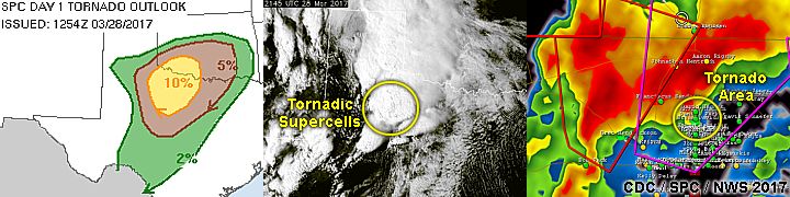
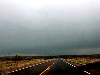
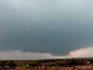
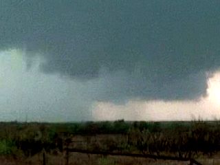
7). March 28, 3:30 PM - Observation of a severe thunderstorm to the west and northwest of Matador, Texas in Motley County and near Highways 62 and 70. The storm was a slightly elevated HP supercell storm. A large slowly rotating wall cloud was observed with some small funnels and possible a brief weak tornado. The storm was in very poor visibility and was undercut by cooler air and in an environment of more stable air. The core (containing golfball sized hail) was not penetrated. Lightning and moderate rain was encountered. Conditions causing the storm were a dryline, low pressure area, upper trough, and surface heating. A 2017 Hyundai Accent was used to chase the storms. Documentation was digital stills and HD video. A tornado watch was valid for the area until 11 PM CDT.
8). March 28, 4:30 PM - Observation and penetration of a very severe and possibly tornadic thunderstorm to the south and southwest of Guthrie, Texas and west of Highway 83 in King County. This storm was a powerful HP supercell, with a wall cloud that rapidly rotated and occluded. When viewed from the east and northeast, looking WSW, a brief tornado was observed with dust and tagging rain curtains before being obscured by (wet) RFD rain wrap (descending reflectivity core). Small hail, 60 MPH winds, frequent lightning, and torrential rains were also observed while proceeding southward through the RFD winds as the storm was completely rain wrapped. Conditions causing the storm were a dryline, low pressure area, upper trough, and surface heating. A 2017 Hyundai Accent was used to chase the storms. Documentation was digital stills and HD video. A tornado watch was valid for the area until 11 PM CDT.
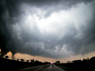
9). March 28, 6:00 PM - Interception, observation, and penetration of an extremely severe and tornadic thunderstorm in Haskell County, Texas near Highways 277 and 6 from Stamford to east of Haskell. The storm was part the "tail end Charley" cluster of supercell storms at the southern end of a messy cluster of supercells arcing along a dryline bulge. One supercell in this cluster (there were three with the strongest tornadic one in the middle) was a cyclic supercell storm. A large stove pipe tornado was encountered with this storm once clearing the precipitation core from the north (I managed to miss the large hail) through the south side of Stamford. Fortunately, the tornado missed the town. The storm was followed north and east around Lake Stamford and it subsequently became outflow dominated northwest of Throckmorton, Texas. Strong winds to 70 MPH, small hail, and frequent lightning was also observed with this storm. Conditions causing the storm were a dryline, low pressure area, upper trough, and surface heating. A 2017 Hyundai Accent was used to chase the storms. Documentation was digital stills and HD video. A tornado watch was valid for the area until 11 PM CDT.
10). March 29, 2:30 AM - Observation of a strong to possibly severe thunderstorm off I-35 at a stationary location (hotel) in Denton, Texas in Denton County. The storm was part of a line of strong and severe thunderstorms moving through the area. Heavy rains, small hail, frequent lightning, and winds to near 60 MPH were encountered. Conditions causing the storm were a low pressure trough, upper trough, and low level jet. A 2017 Hyundai Accent was involved with chasing these storms. A severe thunderstorm watch was also valid for the area until 4 AM CDT.
11). March 29, 7:00 PM - Observation of a strong thunderstorm near De Kalb in Bowie County, Texas and along and to the north of Highway 82. The storm was a low topped LP supercell with a flared out base, corkscrewed updraft, and core of small hail. The storm core was not encountered. Conditions causing the storm were a dryline, low pressure trough, upper trough, and surface heating. A 2017 Hyundai Accent was used to chase the storms. Documentation was digital stills and HD video. A tornado watch was valid for the area until 12 AM CDT the following day.
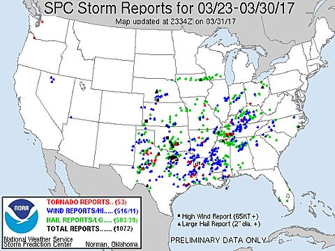
This concludes the chase log for the central US Plains (including chases in Arkansas, Louisiana, Oklahoma, and Texas) chase trip for March 23-30, 2017. The summary includes a total of 11 observations, out of which there were 9 severe thunderstorms and 2 strong thunderstorms. 3 tornadoes were observed from three of the severe storms. The main chase vehicle conducting this chase were two 2017 Hyundai Accents (one for March 23rd to the 27th, and another from the 27th to the 30th, both nearly identical). This information was prepared exclusively for the National Weather service and the team of Skywarn storm spotters.
|
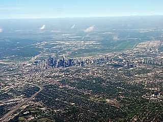
Here is a view of Dallas, Texas while approaching Love Field airport on March 23, 2017. This was the start of the trip, and a rather rushed plan to get to the Texas panhandle as quick as possible. |
|
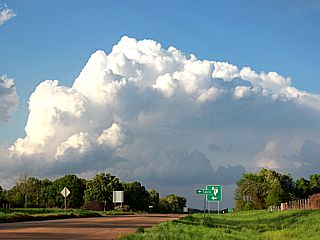
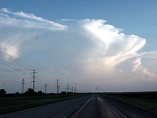
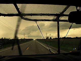
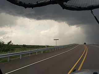
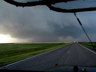
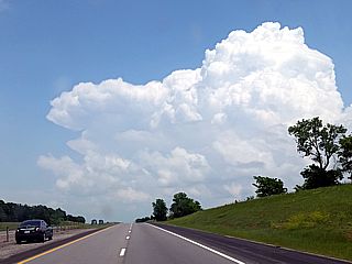
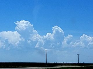
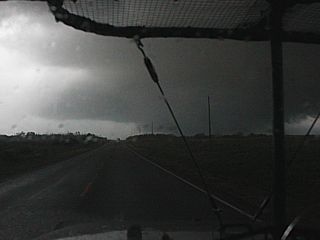
This is a view looking west on I-40 towards Amarillo, Texas. The storm complex is still west of the city, and the anvil blowoff can be seen streaming overhead late in the day on March 23, after a long drive from Dallas. |
|
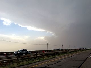
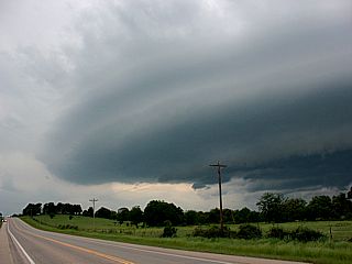
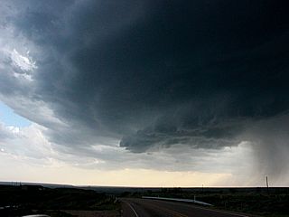
Here is a view of the flanking line and updraft (center and right of the picture) of a supercell storm just west of Amarillo, Texas on March 23. The visibility is compromised by blowing dust. |
|
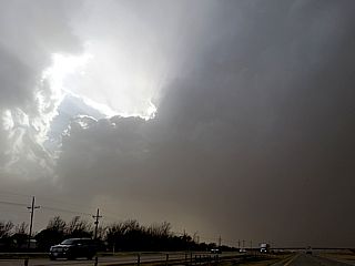
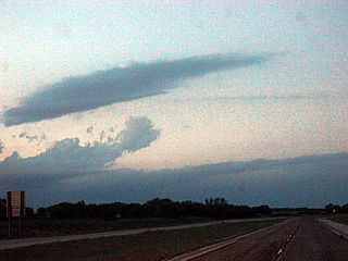
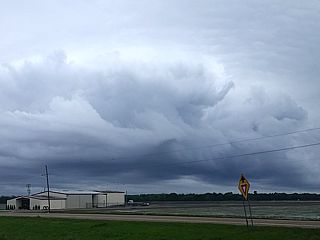
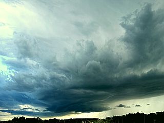
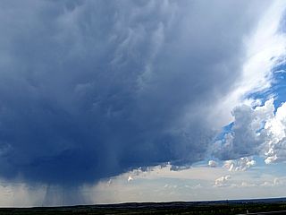
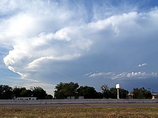
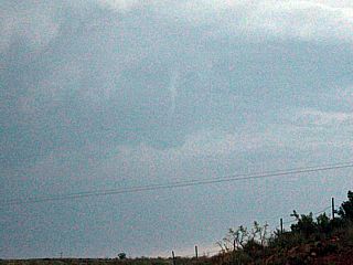
The supercell weakens, and evolves to a line segment as if moves to the northeast of Amarillo, Texas and away from the dryline / moisture axis during the evening of March 23. |
|
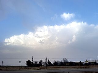
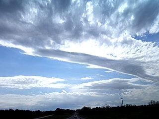
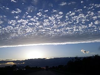
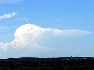
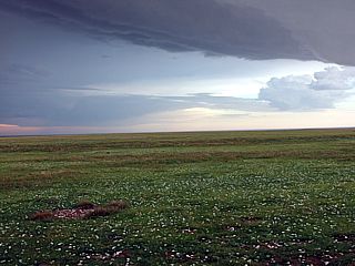
Mid to high altitude cloud formations associated with a strong jet stream and exit region aloft over central / eastern Texas on March 25. This is part of the storm system that provides the upper level air support for severe weather. |
|
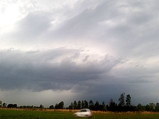
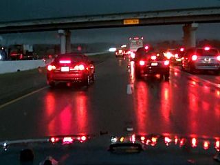
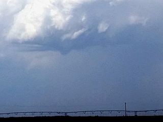
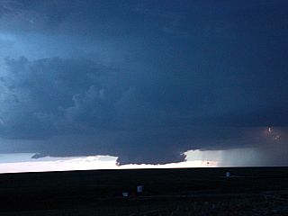
Disorganized severe storm developing near I-30 and Marshall, Texas. This will be a bow segment to produce damaging winds after dark on March 25. |
|
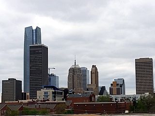
Here is a view of Oklahoma City, Oklahoma (with the Devon Energy building, the tallest skyscraper in the central USA, to the left) while re-positioning north there on the off day of March 27. |
|
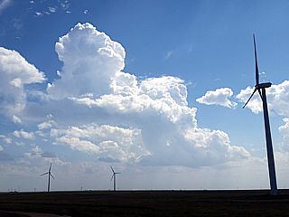
Supercell storms initiating along the dryline west of I-35 and northwest of Davis, Oklahoma during the afternoon of March 26. |
|
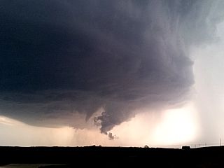
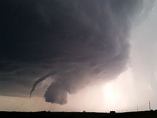
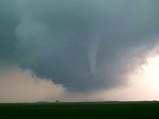
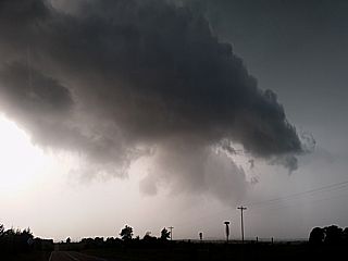
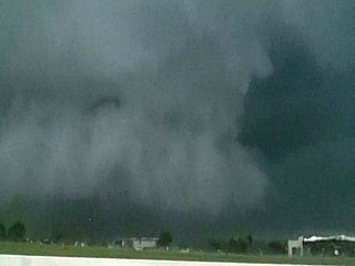
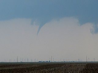
Large rotating wall cloud / funnel approaching Pauls Valley, Oklahoma on March 26. |
|
Hail shaft and greenish hue (and UDI - updraft-downdraft interface) of the first supercell storm approaching Pauls Valley, Oklahoma on March 26. |
|
Hail around the size of golf balls covering the roadway northeast of Pauls Valley, Oklahoma on March 26. This caused minor damage to the rental vehicle. |
|
Developing weak tornado (to far lower right) and updraft tower of the first supercell storm passing to the northwest of Ada, Oklahoma (NE of Pauls Valley) on March 26. Note the striations in the upper part of the picture! This storm would soon weaken due to a strong storm developing southeast of Ada. |
|
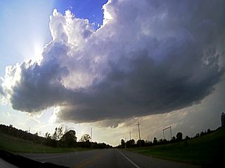
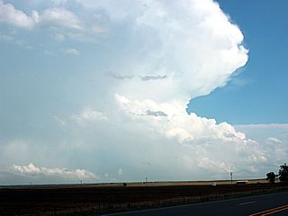
Intense and very photogenic LP (to classic) second supercell storm just to the east of Ada, Oklahoma on March 26. The view is to the west. |
|
Developing tornado east of Ada, Oklahoma on March 26. |
|
Maturing tornado east of Ada, Oklahoma on March 26. |

|
Tornado confirmed via debris cloud on ground, despite the visible funnel being discontinuous. This was east of Ada, Oklahoma on March 26. |
|
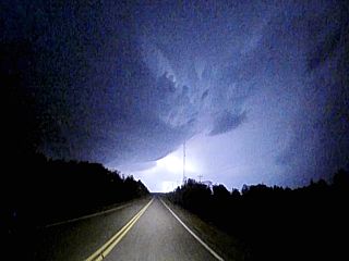
Lightning illuminating the eastern side of the HP supercell as it continues to the northeast into east-central Oklahome after dark on March 26. |

|
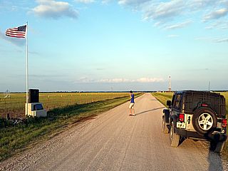
Here is a picture of myself, while driving to Wichita Falls, Texas, after exchanging the car rental for a longer stay. March 27 was an off day. |
|
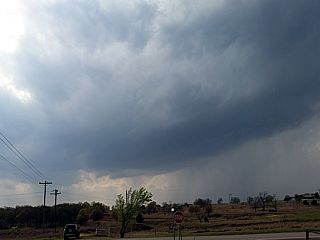
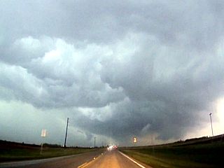
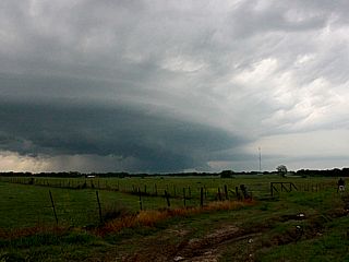
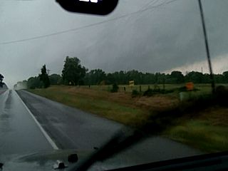
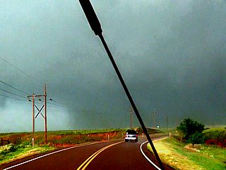
Poorly defined HP supercell (you can barely see the occlusion in the center of the picture) west of Matador, Texas on March 28. The storm was tornado warned at the time. |
|
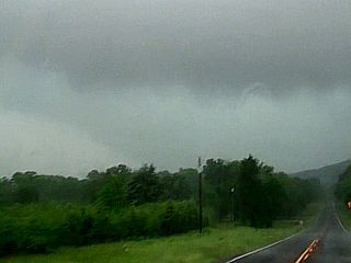
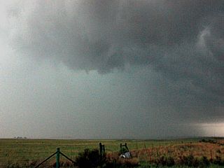
Wall cloud looking southwestward from southeast of Guthrie, Texas on March 28. |
|
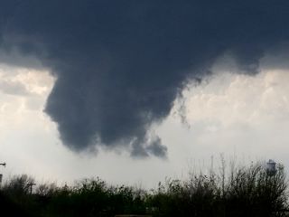
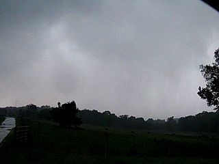
Wall cloud, developing weak tornado (center), and wet RFD occlusion (HP supercell notch) looking southwestward from southeast of Guthrie, Texas. During afternoon of March 28. |

|
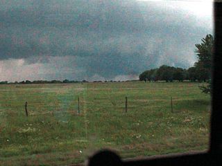
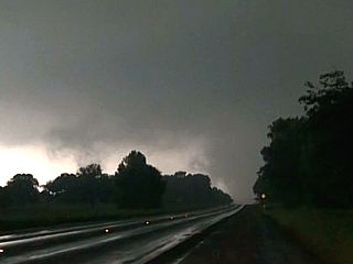
View of large wall cloud and RFD area from the town of Stamford, Texas on March 28. |
|
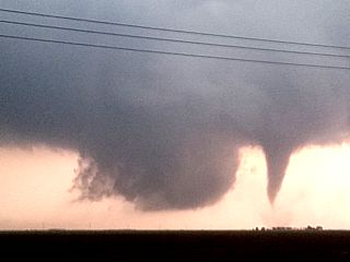
Wide view of intense RFD cut and developing tornado to the far left in the picture looking southeastward of Stamford, Texas during the afternoon of March 28. |
|
Intensifying stovepipe tornado and wall cloud to the east of Stamford, Texas on March 28. |
|
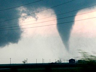
View of stovepipe tornado to the east of Stamford, Texas on March 28. |
|
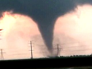
Closer shot of stovepipe tornado and debris cloud to the east of Stamford, Texas on March 28. |
|
Tornado begins to lift and rope out to the northeast of Stamford, Texas on March 28. |
|
Supercell storm begins to become outflow dominant near Lake Stamford in Haskell County, Texas on March 28. |

|
Supercell storm evolves to a line segment north of Throckmorton, Texas late on March 28. |
|
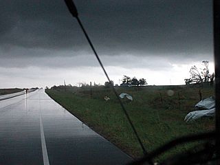
View of developing LP supercell storm with base (note RFD to left developing) near De Kalb, Texas on March 29. |
|
View of LP and low-topped supercell storm with hail core and rain-bow through RFD as is passes north of De Kalb, Texas on March 29. |
|
Here is another view of an LP supercell storm near De Kalb, Texas on March 29. |
|
View of mid to high altitude cloud formations associated with the core of the jet stream passing overhead. The lower clouds are associated with a dryline / Pacific cold front. The view is looking west on I-30 in NE Texas. |
|
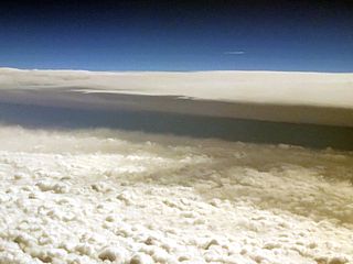
Flying back across the powerful upper level storm system and around convection over the northern Gulf of Mexico and deep south between Dallas, Texas and Fort Lauderdale, Florida. The view is approaching the system from the west, and the anvil blowoff can be seen in the distance. |
|
Moderate to heavy turbulence rocks the plane as it overflies the Gulf states and passes through the upper trough and convection. |
| CHASER NAME | HOME / BASE CITY | CALLSIGN | CHASE DATES | OCCUPATION |
| CHRIS COLLURA | DEERFIELD BEACH, FL | KG4PJN | 4-17 TO 6-26 | IT CONSULTANT |
| DEREK SIBLEY | MOBILE, AL | N/A | 5-9 TO 5-20 | STUDENT |
1). April 19, 5:15 PM - Interception and indirect penetration of a very severe, and possibly tornadic thunderstorm in Cass County, Nebraska to the southeast of Lincoln, and near Eagle along Highway 34. The storm was a classic supercell storm developing in a line segment of strong and severe storms. A large area of rotation, and possible tornado was noted looking west and approaching the storm from the east. The storm weakened but a rotating wall cloud was noted near Manley along SR 1. The core of this storm was not directly penetrated, but had hail up to 2". Penny sized hail, 50 MPH winds, heavy rains, and occasional lightning was noted during my encounter with this storm. Conditions causing the storm were a Pacific front (overtaking a dryline), low pressure trough, upper trough, and surface heating. A 2016 Jeep Wrangler was used to chase the storms. Documentation was digital stills and HD video. A tornado watch was valid for the area until 10 PM CDT.
2). April 19, 7:30 PM - Interception and indirect penetration of a severe thunderstorm from Otoe County, Nebraska along Highway 75 and SR 2 and eastward into Fremont and Page Counties, Iowa towards Bedford. The storm was a small HP supercell embedded in a line segment. A wall cloud and hail core was observed with this storm before it became outflow dominant and weakened into a line segment. The core was not directly penetrated. Lightning, heavy rains, small hail, and 50 MPH winds were encountered. Conditions causing the storm were a Pacific cold front, low pressure trough, upper trough, and surface heating. A 2016 Jeep Wrangler was used to chase the storms. Documentation was digital stills and HD video. A tornado watch was valid for the area until 10 PM CDT.
3). April 20, 10:30 PM - Interception, observation, and indirect penetration of a very severe thunderstorm to the northwest of Vernon, Texas and southwest of Altus, Oklahoma near and south of the Red River along Highway 283, mainly in Wilbarger County, Texas. The storm was one of a few intense elevated supercell storms (north of a stationary front to the south). The core of this storm was not directly penetrated, but contained hail to tennis ball sized (with vertically-integrated liquid / VIL of ~80)! Penny sized hail, heavy rains, 50 MPH winds, and frequent (nearly continuous) lightning with many close hits was encountered with this storm. The storm also had a striking visual appearance (lightning illuminated) with "stacked plates" when viewed from the east. Conditions causing the storm were a stationary front, low pressure trough, upper trough, and intensifying low level jet. A 2016 Jeep Wrangler was used to chase the storms. Documentation was digital stills and HD video. A severe thunderstorm watch was valid for the area until 5 AM CDT the following day.
4). April 21, 9:00 AM - Observation of a severe thunderstorm in Lawton, Oklahoma in Comanche County near I-44 and SR 7 from a stationary location. The storm was the southern end of a line segment of severe thunderstorms. The storm gust front struck; with winds gusting over 60 MPH. Sporadic lightning and heavy rain was also observed after the passage of the gust front surge. Blowing dust and some light debris was noted blowing around. Conditions causing the storms were a low pressure trough, surging outflow boundary, upper trough, and low level jet. A 2016 Jeep Wrangler was used to observe the storms. Documentation was audio and HD video. A severe thunderstorm watch was valid for the area until 12 PM CDT the following day.
5). April 21, 7:00 PM - Interception and observation of a very severe thunderstorm from near Durant, Oklahoma and eastward on Highway 70 to the west of Hugo and near Bennington in Bryan County. The storm was a classic supercell storm, which evolved to HP and later down-scaled to a weak line-segment at dusk. The storm core was not penetrated but probably contained very large hail. A large wall cloud and funnels were also observed with the inflow region of this supercell. The storm also had sporadic lightning and a striking visual appearance ("stacked-plates"). Conditions causing the storm were a prefrontal wave, Pacific cold front, low pressure trough, upper trough, and surface heating. A 2016 Jeep Wrangler was used to chase the storms. Documentation was digital stills and HD video. A tornado watch was valid for the area until 1 AM CDT the following day.
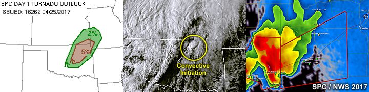
6). April 25, 7:30 PM - Interception and observation of severe thunderstorms from near Burbank to Pawnee in Pawnee County, Oklahoma along Highway 64 and points eastward. The storm started out as a small supercell strong storm, which back-built and evolved into a storm cluster, with an embedded HP supercell. The mail hail core was not penetrated (contained hail to golfball sized). Small hail, 60 MPH winds, very heavy rains, and frequent lightning was observed with this storm. A wall cloud was also noted, but quickly occluded as the storm weakened. Conditions causing the storm were a Pacific cold front, low pressure trough, upper trough, and surface heating. A 2016 Jeep Wrangler was used to chase the storms. Documentation was digital stills and HD video. A severe thunderstorm watch was valid for the area until 2 AM CDT the following day.
7). April 25, 10:00 PM - Interception and observation of severe thunderstorms to the southwest of Tulsa, Oklahoma near I-44 and Sapulpa in Creek County. The storm was an HP supercell storm that was on the southern end of a line segment of severe thunderstorms. The storm quickly evolved to a cluster of strong and severe storms. The core was not directly penetrated. Frequent lightning and heavy rains were observed. Small hail (pea to dime sized) and 50 MPH winds were also encountered at a stationary location near Sapulpa. Conditions causing the storm were a Pacific cold front, low pressure trough, upper trough, and surface heating. A 2016 Jeep Wrangler was used to chase the storms. Documentation was digital stills and HD video. A severe thunderstorm watch was valid for the area until 2 AM CDT the following day.
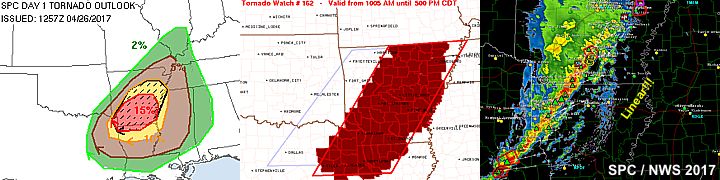
8). April 26, 4:00 PM - Observation of severe thunderstorms from east and southeast of Texarkana mainly in Lafayette and Columbia Counties in Arkansas, from near I-30 and southward to near Highways 82 and 371. The storms were part of a line of strong and marginally severe storms. Heavy rains, 50 MPH winds, sporadic lightning, and small hail were encountered in some of these areas. Conditions causing the storm were a Pacific cold front, low pressure trough, upper trough, and surface heating. A 2016 Jeep Wrangler was used to chase the storms. Documentation was digital stills. A severe thunderstorm watch was valid for the area until 5 PM CDT.
9). April 29, 6:00 PM - Interception and penetration of an extremely severe and violent tornadic thunderstorm in Van Zandt County, Texas between Eustace and Tundra and west of SR 19 and southeast of Mabank. The storm was an HP supercell storm, the middle one in a cluster of three supercells. A brief view of a multivortex tornado was noted looking southwest as the storm occluded, meanwhile a stronger violent tornado was on-going to the WNW (rated EF-4). A brief glimpse of the edge of the EF-4 tornado (that tracked from Eustace to the west of Canton) was noted barely visible through the rain and hail. The core was not directly penetrated, but hail to golfball sized was observed with 65 MPH winds and torrential rains. The storm also produced frequent lightning with some close hits. The tornado quickly became obscured in rain and damage was mainly to trees. Conditions causing the storm were a prefrontal convergence ahead of a Pacific cold front, low pressure area, upper trough, and surface heating. A 2016 Jeep Wrangler was used to chase the storms. Documentation was digital stills and HD video. A tornado watch was valid for the area until 10 PM CDT.
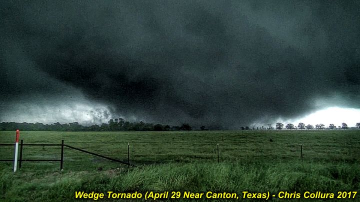
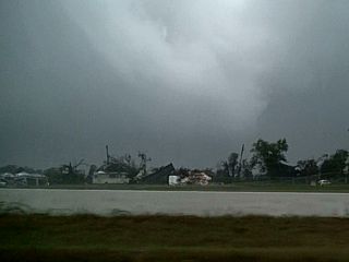
10). April 29, 6:30 PM - Interception and observation of an extremely severe and violent tornadic thunderstorm in Van Zandt County, Texas from near Tundra along SR 19 and north ands east into Canton and eventually Fruitvale. The storm was violent classic supercell storm, and was the southern storm in a cluster of tornadic supercells. The storm produced a highly visible and well documented wedge tornado just east of SR 19 and northward across I-20. The storm also had a striking visual appearance. The tornado hit parts of Canton and Fruitvale, Texas causing deaths and destruction (probably EF-3 or higher damage). Many homes and businesses, including a car dealership, were completely destroyed. Cars also mangled and flipped. High tension transmission lines were also downed by the tornado with a very loud roar noted. The wedge tornado was 1/2 a mile, and maybe as wide as a mile. Frequent lightning with close hits, isolated hail to golfball sized, torrential rains, and winds gusting over 70 MPH (RFD) were also encountered with this storm. Conditions causing the storm were a prefrontal convergence ahead of a Pacific cold front, low pressure area, upper trough, and surface heating. A 2016 Jeep Wrangler was used to chase the storms. Documentation was digital stills and HD video. A tornado watch was valid for the area until 10 PM CDT.
11). May 10, 4:30 PM - Interception and direct penetration of a very severe (and briefly tornadic) thunderstorm from north of Matador, Texas on ranch road 94 in Motley County and north and eastward through Childress County along Highways 62 and 287 east-southeastward to near Quanah, then north and northeastward on Highway 6 to near Altus in Jackson County, Oklahoma. The storm was a classic to HP supercell storm. There was a report of a weak / brief tornado on this storm west of Baker, Texas. The possible tornado was not observed. Passage was done through the storm core and "hook". Hail up to tennis ball sized (2.25") was encountered, with most stones 2". An isolated stone to 3" (baseball sized was seen smashing into the roadway). 60 to 65 MPH winds, torrential rains, and frequent lightning were also observed with this storm. Once east of the storm, a large RFD clear slot, rotating wall cloud, and striking ("stacked plates") visual appearance was noted looking WNW at the supercell. The hail guards were installed for this chase on the Jeep. No windows were lost. The hood was severely dinged by the larger hail-strikes. A small crack was noted in the windshield from a stone that bounced off the roadway. Other vehicles were severely damaged by the hail. Trees had some leaves shredded. Some trees and signs were blown down, and power knocked out. Severe flooding was observed near Altus, Oklahoma, as the supercell storm evolved into a complicated MCS of severe thunderstorms. Conditions causing the storm were a dryline, stationary frontal boundary, low pressure area, upper trough, and surface heating. A 2016 Jeep Wrangler was used to chase the storms. Documentation was digital stills, audio, and HD video. A tornado watch was valid for the area until 10 PM CDT.
12). May 10, 7:00 PM - Interception and penetration of a very severe (and also briefly tornadic) thunderstorm from near Odell and Chillicoth in Wilbarger county, Texas west of Highway 283, then back towards 287 to near Oklaunion, Texas then north on Highway 183 through Davidson and Frederick in Tillman county, Oklahoma then east on SR 5 to near Chattanooga. The storm began as an LP supercell storm southwest of Odell, Texas, and evolved to a classic supercell, then eventually undergone up-scale evolution to an HP storm, and finally a line segment / large MCS after dark. A possible weak and dusty tornado was observed near and north of Davidson, Oklahoma while along 183 south of Frederick. The storm also contained hail to 2", winds gusting near 70 MPH, torrential rains, and frequent lightning (with some close hits). The storm had a striking visual appearance, especially during its early stages. The storm also had a pronounced RFD clear slot and wall cloud before becoming outflow dominated later in its life cycle. Conditions causing the storm were a dryline, stationary frontal boundary, low pressure area, upper trough, and surface heating. A 2016 Jeep Wrangler was used to chase the storms. Documentation was digital stills, and HD video. A tornado watch was valid for the area until 10 PM CDT.
13). May 11, 3:30 PM - Interception and direct penetration of a very severe (and briefly tornadic) thunderstorm from east of Kingfisher, Oklahoma in Logan County and Highway 77, and eastward through Guthrie and Perkins along SR 33 in Payne County, then to Cushing and west of Tulsa in Pawnee County and near Highway 64. The storm was an HP supercell storm that ended as a complex line segment by the end of the period (late afternoon) near Tulsa. A very brief tornado / gustnado occurred with this storm near Perkins, then later after we abandoned the storm well to the northeast of Tulsa near Owasso. The tornadoes were not observed. A spectacular gust front / shelf cloud (as well as undercut RFD cut and wall cloud) were observed with the storm during HP to bow-segment evolution. Extremely large hail was encountered in the core of the HP supercell, with some stones noted to 2.25" (tennis ball sized) and hail drifting from smaller stones on the roadside. The storm also backed winds exceeding 70 MPH, lightning, and violent rain. Conditions causing the storm were a dryline / Pacific front, stationary frontal boundary, low pressure area, upper level low, and surface heating. A 2016 Jeep Wrangler was used to chase the storms. Documentation was digital stills, audio, and HD video. A severe thunderstorm watch was valid for the area until 9 PM CDT.
14). May 11, 7:30 PM - Observation of a strong thunderstorm near I-35 and on the south side of Oklahoma City in Oklahoma County, Oklahoma. The storm was a small elevated LP supercell storm in a small line segment of strong thunderstorms. The storm contained small hail, light to moderate rain, 30 MPH winds, and occasional lightning. The storm had a very striking visual appearance (with striations and a "stacked plates" presentation) when viewed from the ENE. Conditions causing the storm were very cold air aloft, associated with an upper-level low, surface heating, and post-frontal (elevated) forcing in the mid-levels. The storm developed over an area of cool temperatures and winds from the NW. A 2016 Jeep Wrangler was used to chase the storms. Documentation was digital stills. A severe thunderstorm watch was valid for the area until 9 PM CDT.
15). May 14, 4:30 PM - Observation of a strong to marginally severe thunderstorm in Potter County, Texas along Highway 87 / 287 between Dumas and Amarillo. The storm was a marginal supercell storm with a high base that evolved to a line segment. The storm produced light to moderate rain, occasional lightning, small hail, and winds gusting near 60 MPH (mainly in small microbursts). Conditions causing the storm were surface heating, upslope wind flow, a lee surface trough, and a dryline. A 2016 Jeep Wrangler was used to chase the storms. Documentation was digital stills.
16). May 14, 6:30 PM - Observation of strong to severe thunderstorms from near I-24 in Potter County, Texas eastward to Armstrong County through the Palo Duro Canyon near Wayside and SR 207 northward to near Claude. The storm was a cluster of strong and severe thunderstorms. The storms were also high based, and produced light to moderate rain, frequent lightning, and winds gusting near 60 MPH. The core of the storm was not penetrated directly, and a large hail shaft was visible over the canyon back-drop. A small high-based funnel was also observed with a cell that aqcuired LP characteristics near Claude. Conditions causing the storm were surface heating, upslope wind flow, a lee surface trough, and a dryline. A 2016 Jeep Wrangler was used to chase the storms. Documentation was digital stills.
17). May 15, 6:30 PM - Interception and observation of a very severe, and later possibly tornadic thunderstorm from near Stinnet in Hutchinson County, Texas and northeastward towards Spearman in Hansford and Ochiltree Counties along SR 207 and eventually from near Highway 83. The storm was a classic supercell storm, and a large funnel cloud / possible tornado was observed late in the storms life cycle at roughly 9:15 PM looking NW from Highway 83 towards Waka, Texas. The storm had a very striking visual appearance during its mature stages, with a "stacked plates" appearance, and impressive RFD clear slot as well. Hail up to 2" was also noted on the side of the road behind the storm core, which was not directly penetrated. Torrential rains, 60 MPH winds, and frequent lightning were also observed with this storm. Conditions causing the storm were surface heating, a dryline, a surface trough, and upper trough. A 2016 Jeep Wrangler was used to chase the storms. Documentation was digital stills and HD video. A severe thunderstorm watch was also in effect for the area until 10 PM CDT.
18). May 16, 3:30 PM - Interception and observation of a very severe and possibly tornadic thunderstorm from near Perryton in Ochiltree County, Texas and northeastward into Beaver County, Oklahoma along Highways 83 and 270. The storm was a classic supercell storm with a possible tornado observed during its early life to the northwest of Perryton, Texas. The storm produced another funnel cloud and evolved to HP mode as it entered Beaver County, Oklahoma. The core of the storm was not penetrated, but likely contained large hail and strong winds. The storm had a striking visual appearance as well, with wall cloud and RFD cut. The storm eventually evolved to a line segment and weakened after 4:30 PM. Conditions causing the storm were surface heating, a dryline / Pacific front interactions, a low pressure area, and upper trough. A 2016 Jeep Wrangler was used to chase the storms. Documentation was digital stills and HD video. A PDS (particularly dangerous scenario) tornado watch was also in effect for the area until 10 PM CDT.
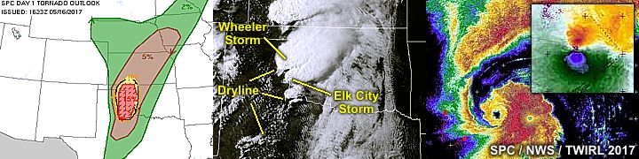
19). May 16, 5:30 PM - Interception, penetration and observation of an extremely severe and tornadic thunderstorm from near Wheeler, Texas in Wheeler County along Highway 83 and south to near Twitty. The storm was an HP supercell with a powerful rain wrapped tornado, and a wide (1/2 mile or so) damage path was observed along Highway 83 south of Wheeler and north of Twitty. Power poles and lines were snapped and across the road, with some debris scattered (roofing material and trees). When the storm was penetrated from the north, rapidly shifting winds (north to west) were noted on the south side of Wheeler with winds approaching 75 MPH. Dime to isolated quarter sized hail, torrential rains, and frequent lightning was also observed. The tornado was rain wrapped and despite being close to our location, not visible. One person was killed in this storm. This was the same supercell and tornado that produced the more visible tornado near McLean, Texas earlier during its classic phase. Conditions causing the storm were surface heating, a dryline, a low pressure area, and upper trough. A 2016 Jeep Wrangler was used to chase the storms. Documentation was digital stills and HD video. A PDS (particularly dangerous scenario) tornado watch was also in effect for the area until 10 PM CDT.
20). May 16, 7:00 PM - Interception, penetration and observation of an extremely severe and potentially violent tornadic thunderstorm from the southwest of Elk City, Oklahoma and southeast of Erick in Becklham County and northeastward to near Thomas in Custer County along SR 152, I-40, and eventually near Highway 183. The storm was an extremely severe HP supercell storm, and produced a large and destructive tornado that caused one death and damage in Elk City, Oklahoma. We approached the storm from the west, and eventually the western circulation of the tornado itself, passing through the intense supercell core and hook region. Extremely heavy rains, and copious amounts of 2" hail, with isolated baseball and even softball sized hail smashing / bouncing across the road - With the alarming silhouette of the developing wedge tornado in front of us on SR 152! The storm also contained frequent lightning (with some close hits). Winds in this area gusted over 100 MPH, especially in rear inflow jets / RFD on the backside of the tornado. A roof and debris (from a steel building disintegrating) was observed airborne off 152 with violently shifting winds as the tornado was highly rain wrapped. Damage in Elk City also was extensive, and debris was noted falling from the sky in RFD winds southeast of there near I-40. The storm continued to the NE into Custer County, Oklahoma and weakened / evolved to a line / bow segment near dusk. Conditions causing the storm were surface heating, a dryline, a low pressure area, and upper trough. A 2016 Jeep Wrangler was used to chase the storms. Documentation was digital stills and HD video. A PDS (particularly dangerous scenario) tornado watch was also in effect for the area until 10 PM CDT.
21). May 18, 3:00 PM - Interception and observation of a very severe thunderstorm from near Fargo, Oklahoma to Fort Supply in Harper County, and along SR 46 to Highways 64 and 183. The storm was a classic to HP supercell thunderstorm. A rotating wall cloud was observed with this storm, but it quickly evolved to a line segment and weakened due to storms developing south and southeast of it. Conditions encountered were heavy rains, frequent lightning, 60 MPH winds, and small hail. The main core was not penetrated. Conditions causing the storm were surface heating, a dryline, a low pressure area, and upper trough. A 2016 Jeep Wrangler was used to chase the storms. Documentation was digital stills and HD video. A PDS (particularly dangerous scenario) tornado watch was also in effect for the area until 8 PM CDT.
22). May 18, 4:30 PM - Interception and penetration of a very severe and tornadic thunderstorm in Woods County, Oklahoma near Camp Houston along Highway 64. The storm was an HP supercell storm with a possible rain-wrapped tornado in progress as it was penetrated from the west. A funnel cloud developing and disappearing into rain was observed, with an area of strong rotation / dust being lofted as the weak tornado developed and lifted north (in poor visibility). Hail to 1", strong winds to 60 MPH, very heavy rains, and frequent lightning was also observed when penetrating this storm. Conditions causing the storm were surface heating, a dryline, a low pressure area, and upper trough. A 2016 Jeep Wrangler was used to chase the storms. Documentation was digital stills and HD video. A PDS (particularly dangerous scenario) tornado watch was also in effect for the area until 8 PM CDT.
23). May 18, 5:15 PM - Interception and observation of an extremely severe and tornadic thunderstorm in Woods County, Oklahoma along Highway 281 and between Avard and Waynoka. The storm was a classic and cyclic supercell storm. A large cone (or even wedge tornado) was observed with this supercell looking southwest from near Avard. The tornado evolved to multi-vortex and then a large wall cloud. Another wall cloud and large funnels developed as the storm cycled. The funnel formed from the new mesocyclone while the tornado near Waynoka was still in progress. The storm also had a very striking visual appearance (with "stacked plates" presentation). This supercell evolved to LP through downscale growth and weakened northwest of Alva. The storm core was not penetrated (contained at least 2" hail), but light rains, 40 MPH winds (inflow), and frequent lightning was observed. Conditions causing the storm were surface heating, a dryline, boundary interactions, a low pressure area, and upper trough. A 2016 Jeep Wrangler was used to chase the storms. Documentation was digital stills and HD video. A PDS (particularly dangerous scenario) tornado watch was also in effect for the area until 8 PM CDT.
24). May 18, 6:30 PM - Interception and observation of a severe thunderstorms from west of Custer City and near highway 183 and SR 33 west of Putnam and Arapaho in Dewey and Custer Counties. The storm was a multicell cluster of strong and severe storms, formed by two supercells evolving to HP and merging ahead of the dryline. A large funnel was observed on the forward flank of the storms west of Putnam, as well as a large shelf cloud towards the southern portion of the storm complex. The cores were not penetrated. Frequent lightning, heavy rains, and 45 MPH winds were encountered. Conditions causing the storm were surface heating, a dryline, a low pressure area, and upper trough. A 2016 Jeep Wrangler was used to chase the storms. Documentation was digital stills. A PDS (particularly dangerous scenario) tornado watch was also in effect for the area until 8 PM CDT.
25). May 19, 1:00 PM - Observation of a very severe thunderstorm near Graham and Archer City, Texas in Archer County and along Highway 79. The storm was an elevated supercell storm at the end of a line segment of strong and severe thunderstorms. The supercell storm was HP in nature, but still north of a boundary separating rain cooled air from earlier storms to its north. The storm had an impressive shelf cloud associated with its gust front. The core (containing golfball sized hail) was not penetrated. Frequent lightning, 40 MPH winds, and light rain were encountered passing the storm. Conditions causing the storm were surface heating, outflow boundaries, a low pressure area, and upper trough. A 2016 Jeep Wrangler was used to chase the storms. Documentation was digital stills. A tornado watch was also in effect for the area until 8 PM CDT.
26). May 19, 6:30 PM - Interception, observation, and penetration of a very severe thunderstorm west of Voss, Texas and near the CH Ivie Reservoir in Concho County and east of Highway 83. The storm was and HP supercell and part of a cluster of strong and severe thunderstorms. The storms were outflow dominant. A rotating wall cloud was also observed before the storm got undercut. The core was not directly penetrated, which contained hail at least 2". Frequent lightning (with some close hits), heavy rains, 60 MPH winds, and small hail was encountered with this storm. Conditions causing the storm were surface heating, outflow boundaries, a low pressure area, and upper trough. A 2016 Jeep Wrangler was used to chase the storms. Documentation was digital stills. A tornado watch was also in effect for the area until 8 PM CDT.
27). May 21, 6:30 PM - Interception and observation a very severe (and possibly tornadic) thunderstorm near McAlister and House in Quay County, New Mexico near SR 206 and 156. The storm was a classic supercell storm, and several large lowerings were observed on its southern side. The storm had a large rotating wall cloud, and several funnels, one of which might have touched down as a weak tornado. The storm core (with hail at least 2") was not penetrated, and the storm was viewed from the east. Frequent lightning, light to moderate rain, and 30 MPH winds was encountered east of the storm and away from the core. The storm was over rural areas. Conditions causing the storm were surface heating, upslope wind flow, a stationary boundary, a low pressure trough, and upper trough (NW flow aloft). A 2016 Jeep Wrangler was used to chase the storms. Documentation was digital stills.
28). May 22, 5:00 PM - Interception and observation a strong thunderstorm over rural areas of Roosevelt County, New Mexico and west of Highway 70 near Delphos and Portales. The storm was a small LP supercell. Conditions encountered were occasional lightning, light rains, 30 MPH winds, and hail up to penny sized. One CG lightning bolt started a grass fire in an open field after it hit. Conditions causing the storm were surface heating, upslope wind flow, a stationary boundary, a low pressure trough, and upper trough. A 2016 Jeep Wrangler was used to chase the storms. Documentation was digital stills. A severe thunderstorm watch was in effect for the area until 8 PM MDT.
29). May 22, 7:00 PM - Interception and observation a very severe thunderstorm from west of Delphos and Kenna, New Mexico in Chaves County along and near Highways 70 and 285, and ultimately eastward along Highway 380 east of Roswell. The storm was an intense LP to classic supercell storm. The storm had a very striking visual appearance during all stages of its lifecycle, including RFD, hail shafts, rock-hard updraft, and rotating high-based wall clouds. The core of the storm was not penetrated, but contained large hail to at least 2". Copious amounts of quarter sized hail was noted along Highway 380 behind the storm. Other conditions were winds over 50 MPH (with dust), light rain, and frequent lightning. Conditions causing the storm were surface heating, upslope wind flow, a stationary boundary, a low pressure trough, and upper trough. A 2016 Jeep Wrangler was used to chase the storms. Documentation was digital stills. A severe thunderstorm watch was in effect for the area until 8 PM MDT.
30). May 25, 3:30 PM - Interception and penetration of a very severe and tornadic thunderstorm from Yuma County, Colorado eastward to near Saint Frances, Kansas along Highway 36 and near Highway 385. The storm was a powerful classic to HP supercell storm. The storm core contained hail to baseball sized. Hail up to golfball sized was observed in the hook of the storm near the intersection of Highways 385 and 36. Much of this hail accumulated on the ground do a depth of a few inches. A weak tornado was observed looking eastward from Highway 385 to the northwest of Hale / Bonny Reservoir and east of Idalia. The tornado was weak, lasted roughly 5 minutes, and remained over an open field. A rotating wall cloud was observed exiting the storm core to the northeast later. The storm also contained 65 MPH winds, torrential rains, and frequent lightning. The storm also had a striking visual appearance, with the base resembling a "cinnamon roll" and the weak tornado under it. Conditions causing the storm were surface heating, upslope wind flow, a stationary boundary, a low pressure lee trough, and upper trough. A 2016 Jeep Wrangler was used to chase the storms. Documentation was digital stills and HD video. A severe thunderstorm watch was in effect for the area until 9 PM MDT (10 PM CDT).
31). May 25, 6:30 PM - Interception and penetration of a very severe and possibly tornadic thunderstorm from near Colby, Kansas along I-70 and southeastward to near Trego Center south of Wakeeney near Highway 283 in Gove and Trego Counties. The storm was an HP supercell storm. A possible tornado occurred with this storm near Oakley, but was rain wrapped and not visible. Strong winds gusting over 80 MPH were encountered east of Oakley on I-70. Torrential rains, quarter sized hail, and frequent lightning with close hits was also observed. Power poles were snapped and some structural damage occurred near Oakley. Flying tree debris was also noted blowing across I-70. Once east of the storm, before being undercut by outflow, the storm had a striated inflow appearance and large wall cloud with RFD clear slot on its southern side before weakening. Conditions causing the storm were surface heating, upslope wind flow, boundary interactions, a low pressure lee trough, and upper trough. A 2016 Jeep Wrangler was used to chase the storms. Documentation was digital stills and HD video. A severe thunderstorm watch was in effect for the area until 10 PM CDT.
32). May 26, 5:30 PM - Observation and penetration of a very severe and possibly tornadic thunderstorm from Arapahoe county near Byers, Colorado via I-70 and Highway 36, then eastward through Washington and Yuma Counties to near Idalia, then eventually (via Highways 36, 385, and I-70) into Kansas near Goodland in Sherman County. The storm was a classic to HP supercell storm. Several penetrations were made on the storm, including a hook slice into the "bear's cage" north of Anton, Colorado. Very large hail, with numerous 2" (and possibly to tennis ball sized) was encountered with this storm. Heavy rains, 60 MPH winds, and frequent lightning were also encountered. A possible tornado was reported near Idalia, but it was low contrast and not visible from my vantage point. The storm had a very striking visual appearance, with striations, RFD cut with funnels, and dramatic "stacked plates" appearance. Conditions causing the storm were surface heating, upslope wind flow, boundary interactions, a low pressure lee trough, and upper trough. A 2016 Jeep Wrangler was used to chase the storms. Documentation was digital stills and HD video. A severe thunderstorm watch was in effect for the area until 8 PM MDT (9 PM CDT).
33). May 27, 7:00 PM - Observation and penetration of a very severe and thunderstorm from near Pawhuska in Osage County, Oklahoma, eastward along Highway 60 through Nowata and Washington County to near Adair. The storm was a classic supercell that evolved to HP, then weakened to a line segment. A wall cloud was observed with the storm early in its life, with a striated "barber pole" updraft. Hail to 2" was encountered while going through the core of the storm near Nowata. The storm also contained frequent lightning (with some close hits), heavy rains, and 50 MPH winds were also encountered. Conditions causing the storm were surface heating, upslope wind flow, dryline / boundary interactions, a low pressure area, and upper trough. A 2016 Jeep Wrangler was used to chase the storms. Documentation was digital stills and HD video. A tornado watch was in effect for the area until 12 AM CDT (the following day).
34). June 12, 4:00 PM - Interception, indirect penetration, and observation of an extremely severe and tornadic thunderstorm in Goshen County, Wyoming near Fort Laramie, along Highways 26 and 85. The storm was a classic to HP cyclic supercell storm. A large rotating wall cloud and striking visual appearance was observed with this supercell, along with a few tornadoes (one a significant stove-pipe type) observed west of Highway 85. The tornadoes were not highly visible. The storm also contained grapefruit sized hail, frequent lightning, heavy rains, and 60 MPH winds. The core was not directly penetrated, and hail to golfball sized was encountered near Fort Laramie. Little damage was noted as the storm remained over open country. Conditions causing the storm were upslope wind flow, a low pressure area, surface heating, and an upper trough. A 2016 Jeep Wrangler was used to chase the storms. Documentation was digital stills and HD video. A PDS (particularly dangerous situation) tornado watch was also in effect for the area until 8 PM MDT (9 PM CDT).
35). June 12, 6:30 PM - Interception, indirect penetration, and observation of an extremely severe and tornadic thunderstorm in Banner County, Nebraska near Harrisburg, along SR 71 south and SR 88 east. The storm was a cyclic supercell storm that had a long history of producing significant tornadoes (along a swath from NE Colorado and into Nebraska). The final tornado this storm produced was observed while heading south on SR 71 north of Harrisburg. The storm evolved to HP mode after this, with an impressive visual appearance. The core was indirectly penetrated, and quarter sized hail, 60 MPH wind gusts, heavy rain, and frequent lightning was encountered. The storm contained grapefruit sized hail in its core earlier, and one of the tornadoes destroyed a house. Conditions causing the storm were upslope wind flow, a low pressure area, surface heating, and an upper trough. A 2016 Jeep Wrangler was used to chase the storms. Documentation was digital stills and HD video. A PDS (particularly dangerous situation) tornado watch was also in effect for the area until 8 PM MDT (9 PM CDT).
36). June 13, 5:00 PM - Interception and penetration of a very severe and tornadic thunderstorm southwest of Plankington, South Dakota in Aurora County, and from near CR 23 to I-90 and near 281 to the north and east. The storm was an HP supercell storm. A large gustnado was observed with this storm as it was near I-90 and before it became outflow dominant. Strong winds to 60 MPH, frequent lightning, quarter sized hail, and heavy rains were also encountered with this storm. Conditions causing the storm were a dryline / Pacific cold front, a low pressure area, surface heating, and an upper trough. A 2016 Jeep Wrangler was used to chase the storms. Documentation was digital stills and HD video. A tornado watch was also in effect for the area until 10 PM CDT.
37). June 13, 5:30 PM - Interception and penetration of a very severe and possibly tornadic thunderstorm from near Stickney, South Dakota in Aurora County to Davison County and near Mitchell, and from Highway 281 to SR 37 via I-90 east. The storm was an intense HP supercell storm with very strong rotation as it was being undercut (again) by outflow. A rotating area with tagging rain curtains was observed near Stickney. The storm also contained quarter sized hail, frequent lightning, 65 MPH winds, and torrential rains. The storm evolved to a line segment, and this was followed as far south as Alexandria near SR 25. Conditions causing the storm were a dryline / Pacific cold front, a low pressure area, surface heating, and an upper trough. A 2016 Jeep Wrangler was used to chase the storms. Documentation was digital stills and HD video. A tornado watch was also in effect for the area until 10 PM CDT.
38). June 13, 8:30 PM - Penetration of a very severe thunderstorm from near Bow Valley, Nebraska in Cedar County, along SR 57. The storm was a line segment of strong and severe thunderstorms. An intense portion of the line was penetrated when back-tracking due to road construction and the area coned off by SR 12. Extremely heavy rains, frequent lightning, heavy and thick hail to 1" (quarter sized) covering the ground, and winds gusting over 70 MPH. Trees were downed along side the vehicle, with a portion of the tree striking the vehicle and breaking off the HAM radio antenna. The storm caused tree damage and power out in many areas as it continued southeastward through Sioux City. This made finding a hotel there very difficult due to wind damage. Conditions causing the storms were a dryline / Pacific cold front, a low pressure area, surface heating, and an upper trough. A 2016 Jeep Wrangler was used to chase the storms. Documentation was digital stills and HD video. A severe thunderstorm watch was also in effect for the area until 1 AM CDT the following day.
39). June 14, 5:00 PM - Observation and penetration of a severe thunderstorm near Hunnewell, Missouri in Marion County near Highway 36, and southward along SR V to near Highway 24 and Stoutsville. The storm was an HP supercell storm that evolved to a line segment after being undercut by strong outflow. An RFD clear slot, rotating wall cloud, and funnel was also observed with this storm during its early stages. Heavy rains, 60 MPH winds, and frequent lightning was also encountered. Conditions causing the storm were a stationary front / outflow boundary, a low pressure trough, surface heating, and an upper trough. A 2016 Jeep Wrangler was used to chase the storms. Documentation was digital stills. A severe thunderstorm watch was also in effect for the area until 8 PM CDT.
40). June 15, 5:00 PM - Interception, observation, and direct penetration of a very severe and tornadic thunderstorm near Lacross, Kansas in Rush County to near Great Bend in Barton County, and along highways 28 / 281 to near Highway 56. The storm was a supercell storm that initiated earlier west of Russell, Kansas. A rotating wall cloud, or even a brief tornado was observed when this storm was first encountered during its early stages and before it split. Later the main southern split was directly penetrated while caravanning with other chaser Dan Shaw and Don Sanderson to report hail sizes. During the core penetrations of the supercell, large amounts of golfball sized hail, with larger 2" (and even one stone to 2.5" baseball sized) also observed. Winds up to 45 MPH, frequent lightning, and heavy rains were also encountered. A wall cloud and RFD was also noted with this storm. Conditions causing the storm were a stationary front and dryline "triple point", a low pressure area, surface heating, and an upper trough. A 2016 Jeep Wrangler was used to chase the storms. Documentation was digital stills, audio, and HD video. A severe thunderstorm watch was also in effect for the area until 7 PM CDT.
41). June 15, 7:00 PM - Observation and penetration of a severe thunderstorm near Saint John, Kansas in Stafford County along highways 50 and 281. The storm was a supercell storm that started as a classic / HP storm, then evolved to a multicell cluster of strong and severe storms near Pratt, Kansas. I was caravanning with chaser Dan Shaw and Don Sanderson on this storm. Hail up to 2", 65 MPH winds, heavy rains, and frequent lightning were all encountered in this storm. At dusk, north of Pratt, and incredible display of mammatus was also observed from SR 61 while Dan gave me a spare antenna to replace the broken one I had. Conditions causing the storm were a stationary front and dryline "triple point", a low pressure area, surface heating, and an upper trough. A 2016 Jeep Wrangler was used to chase the storms. Documentation was digital stills and HD video. A severe thunderstorm watch was also in effect for the area until 2 AM CDT the following day.
42). June 16, 5:00 PM - Interception, observation, and penetration of a very severe and tornadic thunderstorm near Madison, Nebraska in Madison County near Highway 81 and SR 91, and southeastward to near Schuyler in Colfax County and Highway 30 off SR 15. The storm was an HP supercell storm. A possible brief tornado was barely visible early in the storms life cycle near Madison, before intense rain wrap ensued. Winds gusting near 70 MPH, frequent lightning, torrential rains, and small hail was encountered. The storm became outflow dominant near Schuyler. Conditions causing the storm were a dryline, low pressure area, surface heating, and an upper trough. A 2016 Jeep Wrangler was used to chase the storms. Documentation was digital stills and HD video. A severe thunderstorm watch was also in effect for the area until 10 PM CDT.
43). June 16, 7:30 PM - Observation and penetration of extremely severe thunderstorms from near Columbus, Nebraska in Platte County, and southeastward past Saline County to the SW of Lincoln, and through the Beatrice area in Gage County. The storm was followed via SR 15 out of Columbus to SR 33 / 103 to near Beatrice, and Highway 77 back into Kansas to north of Manhattan in Riley County! The initial stage of this storm complex was an HP supercell near Columbus that became outflow dominant and pushed rapidly southeastward thereafter. The storm merged with an LP supercell storm west of Lincoln, briefly producing funnel clouds. The storm complex, now with an embedded mesocyclone, continued southeastward towards Gage County after dusk, with extreme-damaging (derecho / XDW) winds exceeding 100 MPH. The strongest winds encountered with this system were about 70 MPH. Numerous trees down, wind damage, and power poles snapped were observed near Beatrice, making getting through there nearly impossible. Hail to quarter sized, torrential rains, and CONTINUOUS lightning (many close hits as well) were also encountered. At times the lightning was so frequent (more than 10 flashes per second), that if you turned off your headlights you could still see clearly, as if you were in a nightclub. Flash flooding and wind damage was observed in Beatrice, with power out in most areas. Conditions causing the storm were a dryline / outflow boundary interactions, low pressure area, surface heating, and an upper trough. A 2016 Jeep Wrangler was used to chase the storms. Documentation was digital stills and HD video. A severe thunderstorm watch was also in effect for the area until 10 PM CDT.
44). June 17, 7:00 PM - Interception and observation of a severe thunderstorm near Memphis, Missouri in Scotland County, along and near SR 15 and Highway 136. The storm was initially an HP supercell storm, but became outflow dominant and evolved to a cluster of storms as it spread southeastward to near Williamstown. The core of the storm was not penetrated, but contained hail up to baseball sized. Conditions encountered were 60 MPH wind gusts, heavy rain, small hail, and frequent lightning. Downed trees blocked some roads, and I used the vehicle mounted winch to clear a tree off SR A to allow passage. Power was also out in some areas. Conditions causing the storm were a stationary front / outflow boundary, a low pressure trough, surface heating, and an upper trough. A 2016 Jeep Wrangler was used to chase the storms. Documentation was digital stills and HD video. A severe thunderstorm watch was also in effect for the area until 1 AM CDT the following day.
This concludes the chase log for the central US Plains for the main chase "expedition" of 2017 starting April 17 and ending on June 26. The summary includes a total of 44 observations, out of which there were 42 severe thunderstorms and 2 strong thunderstorms. Out of these thunderstorms, as many as 21 tornadoes were observed, with at least 6 of them being significant and / or destructive. The main chase vehicle conducting this chase was a 2016 Jeep Wrangler. All entries for the logs above are for the local time zone unless otherwise noted. This information was prepared exclusively for the National Weather service and the team of Skywarn storm spotters.

|
Packed up and leaving south Florida on April 17, passing through Orlando, Florida and planning to spend the night in Gainesville, Florida. |
|
View of non severe storms in the distance from along I-24 passing through Tennessee en-route to Saint Louis during the afternoon of April 18. |

|
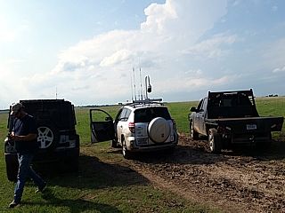
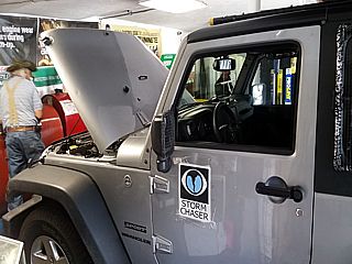
My chase vehicle prepared for hail (grills installed) late in the day on April 19, 2017 near Eagle, Nebraska. |
|
View looking west towards a developing supercell storm near Lincoln, Nebraska from near Eagle. Note the wall cloud and scud tags. |
|
Possible tornado or rotating wall cloud near Lincoln, Nebraska looking west from near Eagle. This was the only storm in that area along the line segments with such rotation. |
|
Rotating wall cloud northeast of Eagle, Nebraska as the storm weakens. |
|
Wall cloud and occlusion of HP supercell storm just east of the Iowa / Nebraska border before the storm weakened. |
|
Looking aouth of a brief LP storm that failed to sustain itself over Haskell County, Texas late in the day on April 20. |
|
The low level jet (LLJ) intensifies and produces these laminar cloud formations as air above it is lifted isentropically. The highly sheared cloud "tower" in the background will eventually develop into an elevated supercell north of the stationary front and produce tennis ball sized hail. |
|
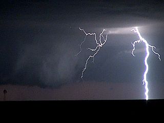
Intense elevated supercell storm and inflow into it as a lightning bolt strikes in the foreground. This was at about 10:30 PM CDT and north of Vernon, Texas on April 20. The view is west from Highway 283 as the storm is producing hail to tennis ball sized. |
|
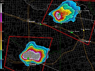
VIL (Vertically Integrated Liquid) image of these two elevated supercells after dark showing values at the top of the VIL scale (80 VIL)! This means these storms are producing extremely large hail (most likely approaching baseball sized, especially on the cell to the lower left). |
|
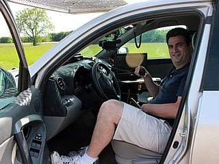
Australian chaser Daniel Shaw joins me on the April 21 chase in Texas / Oklahoma during the afternoon. |
|
Convective initiation while meeting with as local farmer on his ranch outside of Gainesville, Texas. |
|
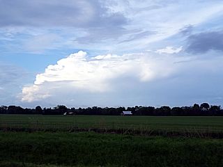
Developing supercell storm (50 miles away) viewed from a farmers ranch north of Gainseville, Texas - Looking northeast. |
|
View of supercell storm from past Durant, Oklahoma. |
|
Suspicious large funnel (or wall cloud) behind the RFD clear slot (center of photo) viewed from a distance past Durant, Oklahoma. |
|
The supercell near Bennington, Oklahoma begins to weaken, but not before displaying this "stacked plates" structure on it's southern side. |
|
The sky takes on an eerie green color at dusk while passing between two severe hail storms. |
|
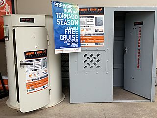
While stopping at Home Depot in Paris, Texas, I came across these tornado shelters for sale. And, you get a free cruise (in the Central USA?) if you purchase one! |
|
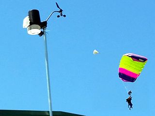
April 23 was another off day, so I decide to do some skydiving at Skydive Spaceland Dallas northeast of McKinney, Texas. |
|
April 24 was an off day and was spent re-positioning north to Oklahoma City. |
|
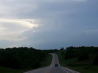
Convective initiation underway to my west, looking westward towards a small supercell developing near Stillwater, Oklahoma on April 25. |
|
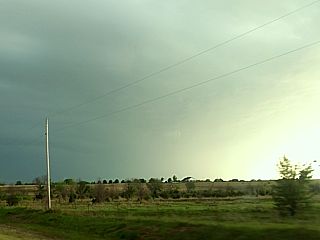
Eerie green color of a developing hail core (to the right in this picture) while heading south on SR 18 towards Pawnee, Oklahoma. |
|
Wall cloud associated with an HP supercell storm near Pawnee, Oklahoma. The view is WNW. |
|
Wall cloud before occlusion of and HP supercell near Pawnee, Oklahoma and transition to a line segment of severe thunderstorms. |
|
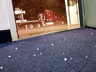
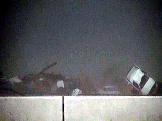
Small hail blows into my hotel room southwest of Tulsa, Oklahoma during late evening passage of an MCS on April 25. |
|
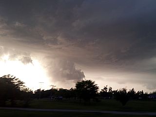
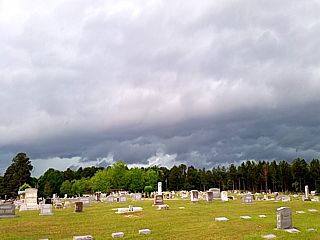
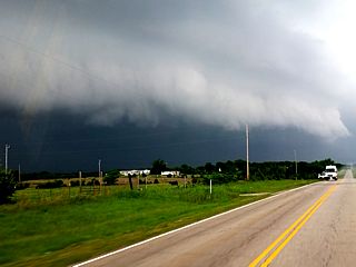
This was to be the most "spectacular" shot of the day, despite a high-end moderate risk issued by the SPC. Here a shelf cloud / gust front approaches a cemetery near Magnolia, Arkansas on April 26. |
|
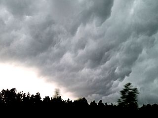
View of "whales mouth" (backside of shelf cloud) near Magnolia, Arkansas. |
|
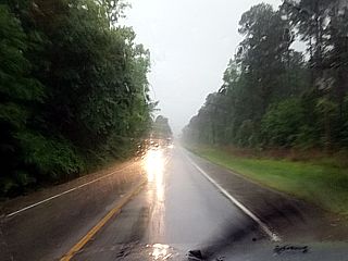
This is the view most storm chasers will have chasing in many parts in Arkansas. Even if there was a large tornado, it would be difficult - and dangerous - trying to see it through these trees! |
|
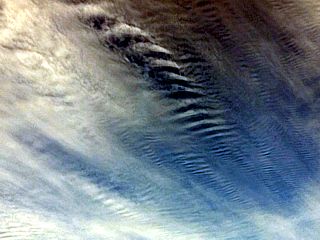
April 27 was a down day / reposition to Oklahoma from Texas. Looking overhead during the afternoon, the strong jet streak (125+ knots at the jet stream level) causes streaking / "herring bone" waves in the fast moving high clouds. |

|
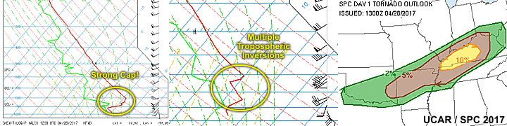
Waiting for storms under a strong cap (temperature inversion aloft that suppresses storm development) in Pauls Valley, Oklahoma with Jerry Prsha and his chase partner late in the day on April 28. |
|
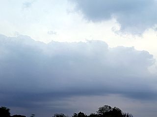
By looking at the tops of the cumulus clouds struggling to develop vertically near the warm front over south-central Oklahoma, it becomes apparent the capping inversion is holding. The flat tops of the clouds denote the inversion is present by early evening on April 28. |
|
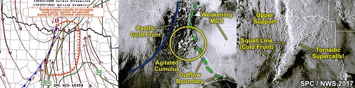
Shelf cloud associated with one of many outflow boundaries in south-central Oklahoma early on April 29. |
|
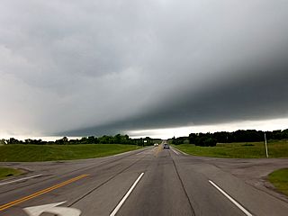
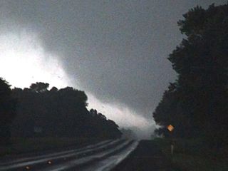
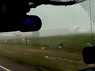
Approaching a soon to be violent cyclic tornadic supercell back-building to the south of Canton, Texas (Highway 19) at around 6 PM CDT on April 29. This storm has a developing tornado that will affect Eustace and Tundra with a weak rain wrapped tornado, then ultimately a strong to violent tornado afterwards. Note the "fog" to the left just above the roadway, caused by the intense pressure drop (ears also popping) under the supercell tornado cyclone! |
|
Possible view of the Eustace to West Canton tornado becoming rain-wrapped. The left edge of the tornado can be seen left of the center of this picture. This tornado was rated EF-4 and was a violent, but less visible tornado. The view here is from west of Highway 19 near Tundra and looking towards the WSW at around 6 PM CDT. |
|
This is what appears to be another tornado (but probably weak and EF-1 or less) also rain-wrapped and passing west of Highway 19 near Tundra, Texas at around 6:05 PM CDT. The view is southwest. I think this may be a satellite vortex going around the main Eustace to W Canton EF-4 tornado that was not visible at the time to my WNW. A loud roar was also audible at this time. |
|
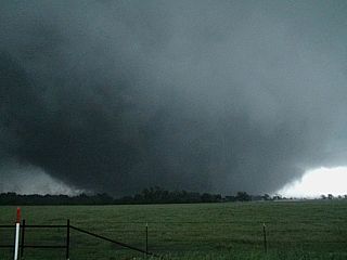
Developing strong tornado crossing road looking southward on Highway 19. This tornado will become a very large tornado causing at least EF-3 damage. This was NOT the same tornado that was rated EF-4 and passed west of Canton and was rain-wrapped - And probably still on going as this one was starting! |
|
Close-up of tornado core flow crossing Highway 19 (from about one mile to the north) looking southward. |
|
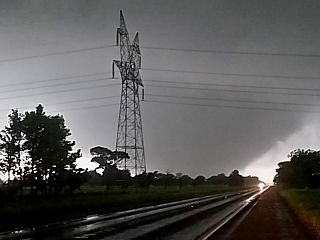
Frightening silhouette of the tornado approaching high-voltage transmission lines. The tornado is widening and intensifying rapidly. The view is south and southeast. |
|
Maturing tornado at about 6:15 to 6:20 PM CDT destroying transmission pylons to the southeast of Canton, Texas. Tornado at LEAST EF-3 strength at this point. The view is to the southeast. |
|
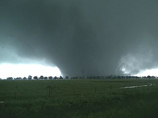
Tornado at about 6:20 PM CDT in wide wedge phase, continuing to the NE and just about to hit the eastern side of Canton, Texas. The view is to the east. |
|
Wedge tornado still widening and incredible low level mesocyclone looking eastward out my passenger window from Highway 19 in Canton, Texas. The tornado is about to cross I-20 at this point. |
|
Heading east on I-20 and coming across many people seeking shelter under this highway overpass. This is NOT a place to be in a tornado, and is obviously obstructing traffic. |
|
Massive wall cloud / violently rotating mesocyclone and RFD cascading looking northward from I-20 at 6:30 to 6:35 PM CDT. The car dealership that got destroyed is to the right in this picture. These were extremely fast moving clouds. |
|
View of devastation to the car dealership seconds after the tornado hit on the north side of I-20 at around 6:35 PM CDT. |
|
More damage looking north of I-20 seconds after the tornado passed through on the east side of Canton, Texas. Unfortunately this storm killed at least 5 people from Canton to Fruitvale farther north. |
|
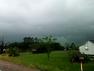
Looking north and northwest from Highway 80 on the eastern side of the damage path in Fruitvale, Texas at roughly 7 PM CDT. Note the home to the right missing a roof. I was unable to get farther into the damage path due to roads blocked. In this picture, the tornado is still visible in the sky moving off and becoming rain wrapped to the right. |
|
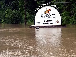
Major flooding was also a part of this weather system passing over the central USA around April 29-30. This is one of many flooded scenes across Arkansas (Lonoke in this case). |
|
Small and low topped storms struggled to develop near the warm front in Illinois, but couldn't sustain themselves. |
|
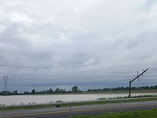
Broken power pole and flooding in southern Illinois off I-57. The water to the left is a flooded farm, NOT a lake! |
|
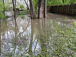
Flooded backyard in the suburbs west of Chicago, Illinois while spending off time there starting on May 1. The water levels may remain high for up to a week after this storm system. |
|
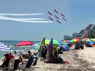
May 1-9 was off-time and I took a break from storm chasing, spending the off-time in Chicago and back in south Florida, returning May 8 to the central USA. In this picture, I am enjoying the Fort Lauderdale air show on May 7. |
|
May 9 was a trip back out to the Plains from Chicago (after arriving back there May 8), and meet up with Derek Sibly who drove out from Alabama that same day. In this picture we are visiting the memorial for Tim and Paul Samaras / Carl Young near El Reno, Oklahoma before heading west to Clinton for the night. |
|
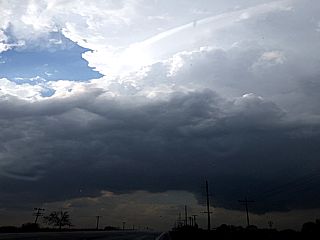
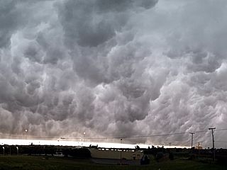
Impressive "whales mouth" (turbulent backside of shelf cloud) associated with the passage of a severe thunderstorms gust front during the morning of May 10 in Clinton, Oklahoma. |
|
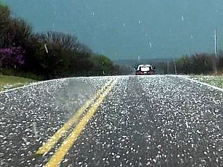
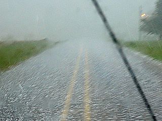
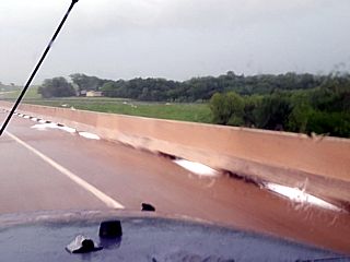
View penetrating the hail core of a supercell storm between Childress and Matador, Texas along a ranch road near Cee Vee. Most of the hail here is quarter sized, but will approach baseball sized later on! |
|
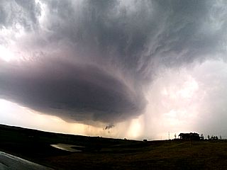
Intense RFD clear slot and rain free "horseshoe" base north of Quanah, Texas and near the Red River. |
|
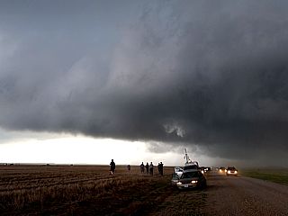
Storm chasers observing the gust front and outflow of the former supersell storm approaching Altus, Oklahoma during the afternoon of May 10. Tim Marshall is there with the TWIRL group in the foreground. |
|
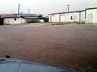
Severe street flooding in Altus, Oklahoma after passage of the HP to MCS storm complex! |
|
New LP supercell storm developing on the dryline father southwest towards Odell, Texas and west of Highway 283 late on May 10. |
|
Gustnado dust and RFD winds near Highway 283 and 287 as the LP supercell evolves to classic mode late on May 10. |
|
Possible brief (but weak) tornado north of Davidson, Oklahoma. Note the RFD slot to the left. The possible tornado is in the center (or slightly right of) in this picture. |
|
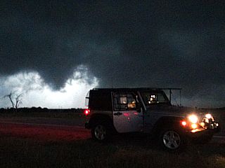
Lightning illuminated shelf cloud with weak shear funnel / scud tag with my Jeep in the foreground while ending the chase after dark on May 10. |
|
Convective initiation looking northward on I-35 and approaching Guthrie early in the afternoon on May 11. |
|
View of hail along the side of the road while approaching the supercell storm that initiated near Kingfisher and is now near Perkins, Oklahoma while catching up to it after a fuel stop. |
|
View looking NW from near Cushing, OK as the HP storm was becoming outflow dominant. The wall cloud (note RFD cut as well) is being undercut, and the storm is evolving into a line segment. |
|
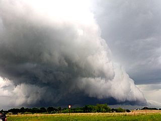
View of gust front and shelf cloud of the MCS as it approaches Pawnee County, OK during the afternoon of May 11. One of the chase tour vans is having problems with blue smoke coming out of its exhaist up the street as well. |
|
View of rain free base on the south side of the line segment pushing through Sapulpa, Oklahoma. |
|
Elevated LP supercell storm looming over I-35 in Oklahoma City, Oklahoma during the late afternoon / early evening of May 11 as the cold core moves overhead. |
|
May 12 was an off day and the start of another lull in the activity for a few days. Derek headed home for a while and I am getting routine service done (oil changed) on my vehicle in Oklahoma City due to the high mileage. May 13 was also an off day and was spent near Denton, Texas before heading back west for the next approaching setup. |
|
Convective initiation looking westward from Highway 287 towards Amarillo, Texas early in the afternoon on May 14. |
|
High-based marginal supercell storm developing between Amarillo and Dumas looking west of Highway 87 / 287. The precipitation (containing small hail) mostly is evaporating before reaching the ground. The cloud base appears "glacial" because it's above 10 or 15 thousand feet (MSL). |
|
View looking northeastward from near Dumas, Texas at a distant supercell storm explosively developing 85 miles away north of Guymon, Oklahoma |
|
This small high-based funnel developed on an LP storm as part of a cluster of storms near Claude, Texas. |
|
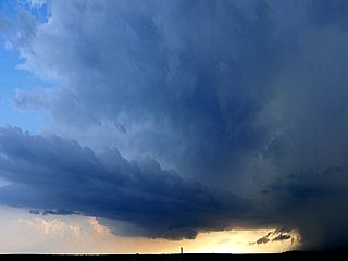
Spectacular view of hail shaft of a severe thunderstorm over the Palo Duro Canyon in Texas (SE of Amarillo) late in the afternoon of May 14. |
|
View of backside of storm anvil spreading out north of Panhandle, Texas late in the day near sunset on May 14. |
|
Convective initiation to the north of Amarillo, Texas late in the day on May 15. |
|
Mature supercell storm near Stinett, Texas. The storm had a classic supercell structure, with "stacked plates" appearance. |
|
Strange mid-level funnel near a mid-level inflow band to the northeast of the Stinett, Texas supercell. |
|
Copious amounts of hail at least golfball sized covering the landscape to the north and east of Stinett, Texas. |

|
One of the larger pieces of hail picked up off the side of the roadway northeast of Stinett. |
|
Large wall cloud forming as the supercell back-builds and moves near Waka, Texas at about 9 PM CDT in twilight. The view is towards the northwest from Highway 84 near Canadian, Texas on May 15. |
|
Possible brief tornado forms off the rotating wall cloud near Waka, Texas at about 9:15 PN CDT. The remaining twilight provides good contrast. |
|
Intense CG lightning bolt and wall cloud near Waka, Texas during the evening of May 15. |
|
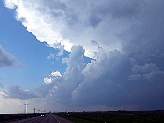
One of the first supercells of the day develops near the intersection of a surface boundary and dryline at roughly 3:30 PM CDT to the west and northwest of Perryton, Texas on May 16. The view is to the west, looking at the classic supercell storm updraft and anvil blowoff overhead. |

|
The storm produces a small cone tornado (ground circulation confirmed by another observer closer in) to the northwest of Perryton, Texas. The image is from a highly zoomed video frame grab. |
|
Here is a picture of a persistant funnel on the classic supercell storm as it moves northeastward towards the OK / TX border into Beaver County, Oklahoma. |
|
After abandoning the storms to the north, we headed south and penetrated the Wheeler, Texas supercell. This view, looking east from just south of town, shows the wet RFD. A large rain-wrapped tornado is in there, not visible, but probably to the left in this picture. |
|
Downed powere poles and debris along Highway 83 south of Wheeler, Texas after the passage of a rain-wrapped tornado. One person was killed from this tornado. |
|
Yet another supercell storm develops on the southern portion of the complex of supercell storms. This is looking ESE towards Erick, Oklahoma from near I-40 and Highway 83. This will produce the tornado that hit Elk City, killing one person and causing damage on the south side of that town. |
|
This is the Elk City tornado in its development stages (multi-vortex / wedge) southeast of Erick and southwest of Elk City, Oklahoma late in the afternoon, early evening on May 16. The view is north and northeast. |
|
Heading east on SR 152, extremely large hail smashes into the roadway in front of us. This is a stone about 4" (between baseball and grapefruit sized) smashing into the road and shattering. |
|
Approaching the developing (and rain wrapped) wedge tornado from the west on 152 and southwest of Elk City. The view is to the east, with the northern edge of the tornado visible. |
|
Southern edge of the wedge tornado intensifying and taking aim on Elk City while stopped in powerful rear inflow jets and looking east on SR 152. |
|
Debris blowing around and on the side of SR 152, to the right, a building is being destroyed and the metal roof is airborne with white spray or material streaming out (grain / flour?). |
|
This is the view looking northward towards Elk City (which would be far left in this picture). The tornado is rain wrapped and not visible. Note the tremendous inflow features going from right to left behind the wet RFD surge in the foreground and to the left. |
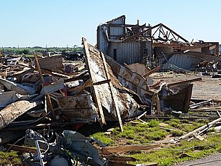
|
May 17 was an off day despite distant chase prospects in Iowa, we decided to stay in the Oklahoma City area to catch up as May 18 was to be another busy chase day. In this picture, we are doing a damage survey in Elk City, Oklahoma after the tornado there a day prior, which caused extensive damage to the south side of the city. |
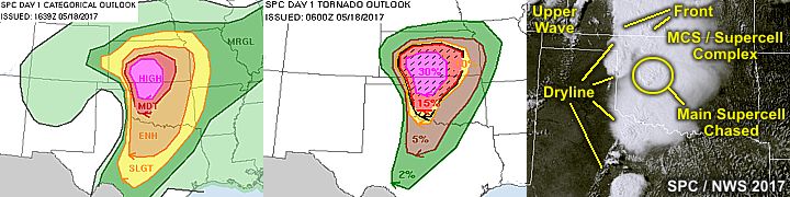
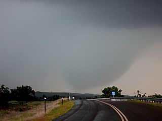
|
Ominous view near Fort Supply, Oklahoma looking NW at a developing supercells core on the high-risk chase day of May 18 during the early afternoon. This is NOT a tornado, but a descending wet microburst loaded with rain and hail. |
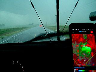
|
View slicing through the hook of an HP supercell west of Alva, Oklahoma with the radar image of the storm in the foreground on the Smartphone. |
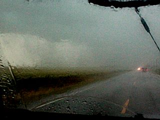
|
Possible rain-wrapped tornado to the west and northwest of Alva, Oklahoma on May 18. The tornado would be to the left in this picture. The view is to the east. |
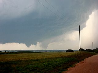
|
First view of the Waynoka tornado from near Avard, Oklahoma looking to the west and southwest during the afternoon of May 18. The tornado, although weakening, is in the center of this picture. The next storm "cycle" is to the left of that (funnel / rotating wall cloud). |
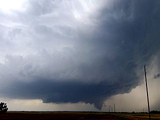
|
New rotating wall cloud / funnel near Avard on the Waynoka cyclic supercell. The storm was classic structure, with a striking visual appearance. |
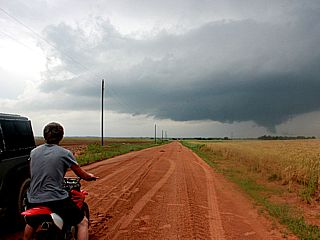
|
Funnel and supercell structure with a teenager (from a local farmstead riding his dirtbike) watching it. The view is to the west near Avard, Oklahoma. |
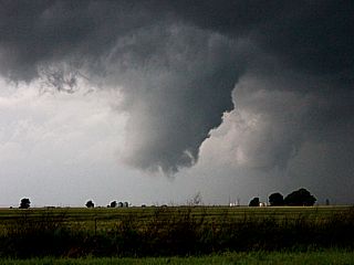
|
Rotating wall cloud / funnel on the weakening supercell as it moves west of Alva, Oklahoma from near Avard. |
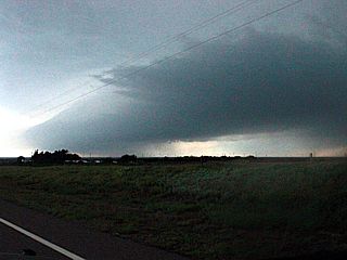
|
Former supercell storm near Custer City, Oklahoma becoming outflow dominant ahead of the dryline and evolving into a bow segment late in the day on May 18. |
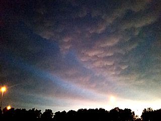
|
Mammatus and interesting gravity waves over Clinton, Oklahoma during the evening of May 18. |
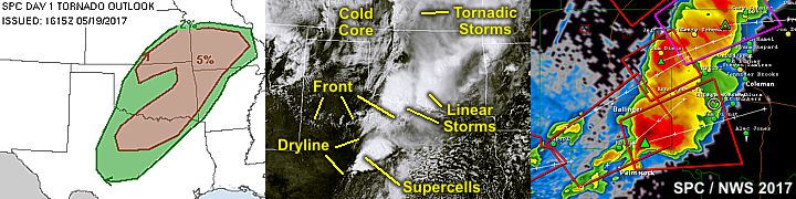
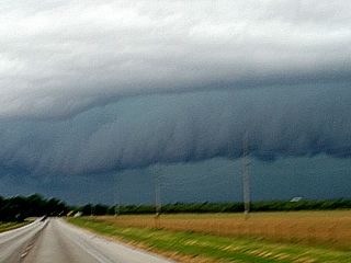
|
Shelf cloud north of Archer City, Texas during the early afternoon of May 19. |
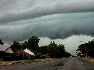
|
Gust front and shelf cloud associated with elevated severe storms passing over Graham, Texas during the early afternoon of May 19. |
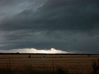
|
Wall cloud on supercell storm before being undercut by outflow near Archer City / Graham, Texas during the early afternoon of May 19. |
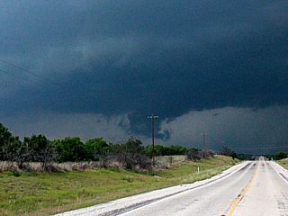
|
Weakly rotating wall cloud to the west and southwest of Coleman, Texas on an outflow dominant supercell storm during the afternoon of May 19. |
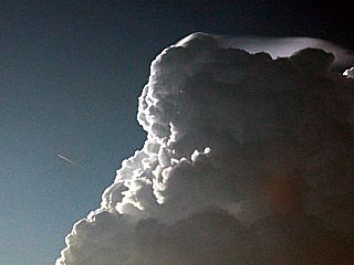
|
View of developing LP supercell storm to the northwest of Acampo, Texas on May 19. Note the beautiful pileus cloud cap, and jet airliner passing the storm tower to the left. |
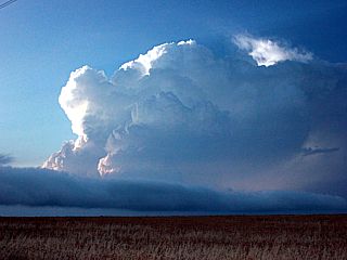
|
Supercell storm and roll cloud looking northwest from near Acampo, Texas. |
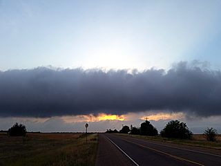
|
Interesting roll cloud moving across the Texas plains late in the day on May 19 near Acampo, Texas. |
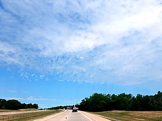
|
View of sky with ACCAS (altocumulus castellanous) clouds over I-35 while heading northward to Oklahoma City out of Texas. |
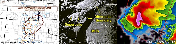
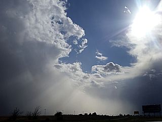
|
View of sky in western Texas just east of the New Mexico border near Vega late in the day on May 20. The weak convective showers have hail and snow aloft due to the colder environment just above the surface in the high plains. |
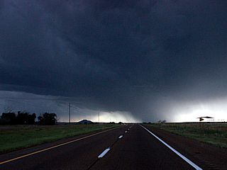
|
Approaching two supercell storms near Tucumcari, New Mexico late in the day on May 20. The view is west on I-40 at the northern storm, which is weaker and high based. Note the inflow bands to the left. |
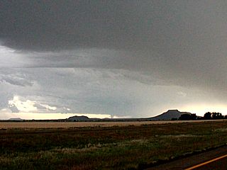
|
Large rotating wall cloud / funnel, and possibly a developing tornado looking to the southwest off I-40 towards Quay County, New Mexico. |
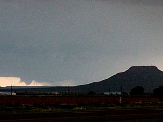
|
Closer view of this funnel / tornado over Quay County, New Mexico. The view is to the southwest from I-40 at about 7:15 PM CDT (6:15 mountain). |
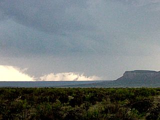
|
Rotating wall cloud / or even a dusty tornado on the persistent storm in Quay County, New Mexico looking west from SR 206. This was roughly 6:30 MDT (7:30 central). The storm had a well-defined couplet and hook at the time, but began weakening after that. |
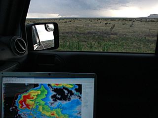
|
View of laptop with radar image (base reflectivity) of the supercell storm in the foreground, and the storm itself out the passenger side window to the west. |

|
Full wide angle view of an impressive rainbow at sunset in Quay County, New Mexico. |
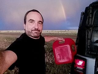
|
Myself fueling up the vehicle with the rainbow behind me in open country in New Mexico. There is no place to get gas in these areas, so carrying spare fuel is a MUST. |
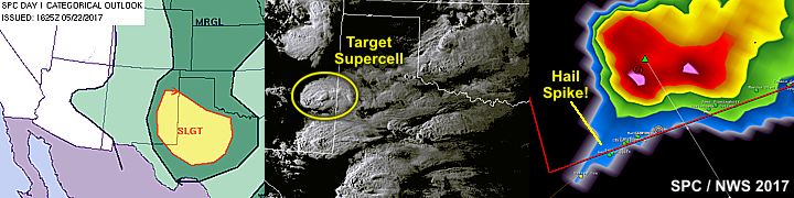
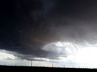
|
View of first small supercell of the day encountered west of Portales and Floyd in eastern New Mexico during the afternoon of May 22. The view here shows the RFD clear slot, looking towards the southwest. Small hail was falling at the time. |
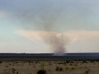
|
Grass fire started by a "dry" lightning strike over rural areas west of Portales, New Mexico. |
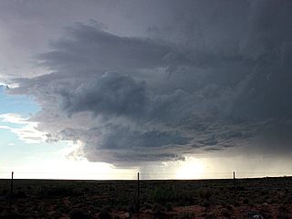
|
Intensifying LP supercell storm to the northwest of Highway 70 near Kenna, New Mexico. The storm is producing large hail at this time. The view is to the west. |
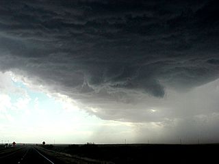
|
High based wall cloud over Highway 70 near Elkins, New Mexico late in the afternoon of May 22. Large hail is to the right. The view is to the west and southwest. |
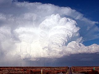
|
Incredible updraft of the supercell storm moving southeast over Chaves County, New Mexico east of Roswell. The storm was tornado warned at this time. The view is to the east on Highway 380. |
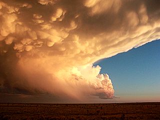
|
View of weakening LP supercell storm south of Highway 380 and mammatus / anvil blowing off to the left. The view is to the south. |
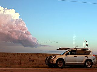
|
Dan Shaw on Highway 380 east of Roswell, New Mexico in his chase vehicle, as the supercell storm weakens in the background over Chaves County. |
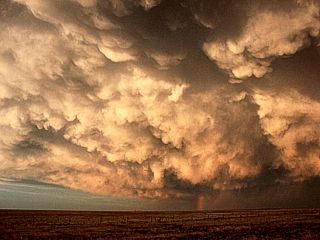
|
The weakening supercell storm produced a large canopy of mammatus clouds, under-lit by the setting sun late in the afternoon / evening of May 22. |
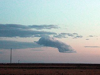
|
This is what was left of the "raging" supercell over Chaves County, New Mexico. In a process called down-scaling, the storm basically shrinks until its no more. This rotating cumulus is what is left just prior to the storm evaporating to nothing. |
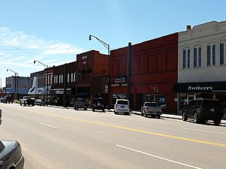
|
These days were off days / travel days without much in the way of storms. This is a picture of the main street in the small town of Weatherford, Oklahoma. |
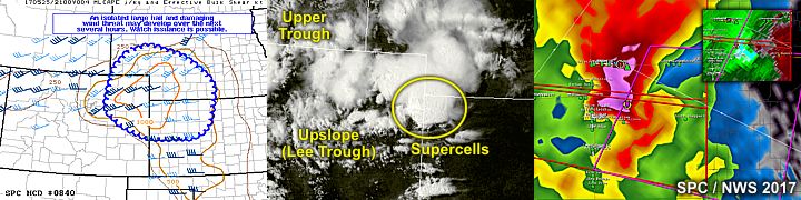
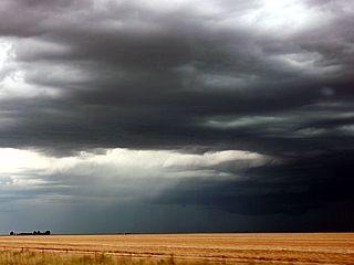
|
Developing supercell storm over Yuma County, Colorado during the afternoon of May 25. The RFD slot can clearly be seen just below the center of the picture, although the base of the storm is still high. A lower cloud base is barely visible to the right of that. The view is northwest. |
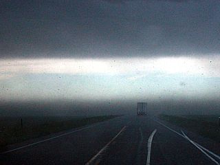
|
Hail fog and some dust blowing from north to south across highway 36 looking east. This was to the south of a rapidly intensifying supercell storm. |
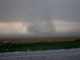
|
Weak tornado viewed from inside the hail core looking east north of the Bonny Reservoir and east of Idalia, Colorado. Time is roughly 3:30 PM MDT on May 25. |
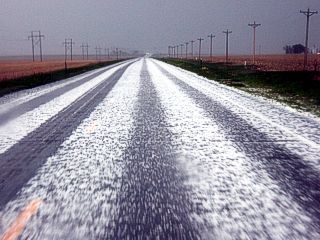
|
Hail covering Highway 385 just behind the Idalia storm. |
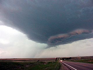
|
Weakening storm to the west of Wheeler, Kansas. The view is to the west, and the storm base is again higher after the wet RFD has occluded. |
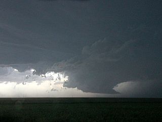
|
Large wall cloud (before getting undercut by outflow) to the southwest of Wakeeney, Kansas later on as the southern supercell begins to wind down late on May 25. |
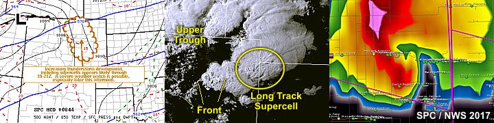
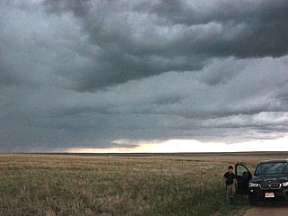
|
Upslope convection (convective initiation) west of Byers, Colorado during the afternoon of May 26. This "innocent" looking cloud will become a long-track supercell that will last nearly 8 hours! |
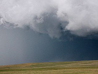
|
Funnel on intensifying supercell storm off Highway 36 east of Byers, Colorado. |
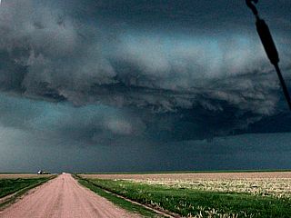
|
Supercell storm intensifying north of Highway 36 and entering Yuma County in Colorado. |
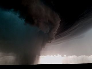
|
Area of intense rotation deep inside the "bear's cage" of the storm north of Anton, Colorado. Isolated baseball sized hail was falling at the time. The rain / hail "core" just left of the center of the photo is rotating hard and can possibly be a weak tornado. |
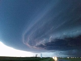
|
Impressive view of the storm near Goodland, Kansas off I-70. |
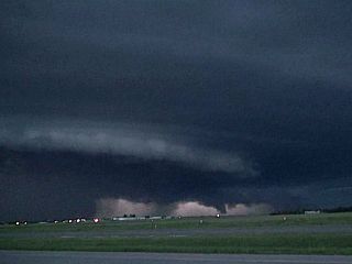
|
Lightning illuminated HP storm evolving to bow segment near Goodland, Kansas late on May 26. There are a few funnels on the forward flank of the storm. |
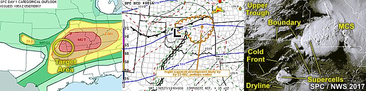
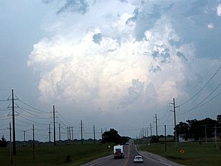
|
Convective initiation looking eastward from near Pawhuska, Oklahoma. This was a linear storm complex along an outflow boundary late in the day on May 27. Another isolated supercell will soon develop west of this area and produce large hail. |
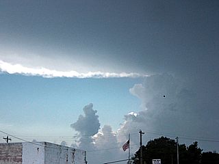
|
Supercell storm developing near Pawhuska, Oklahoma looking westward. The storm was a classic supercell storm during its early phases. Note the anvil blowoff and sharp anvil edge. |
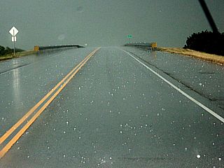
|
Hail up to golfball sized in the roadway near Nowata, Oklahoma as the supercell passes overhead. |
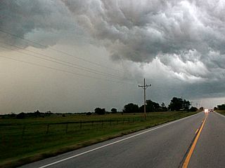
|
The short-lived supercell storm becomes outflow dominated and evolves to a bow segment. In this view, we see the outflow and "green colored" hail core to the left. The view is to the northeast near Adair, Oklahoma. |
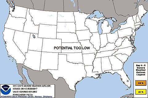
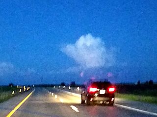
|
Small distant cumulonimbus while driving along I-55 near Normal, Illinois en-route to Chicago on May 28. |
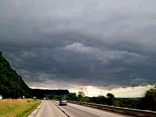
|
This is a picture of the southern edge of a severe storm over western Wisconsin is being passed while en-route to South Dakota from Chicago and crossing the upper Mississippi River. |
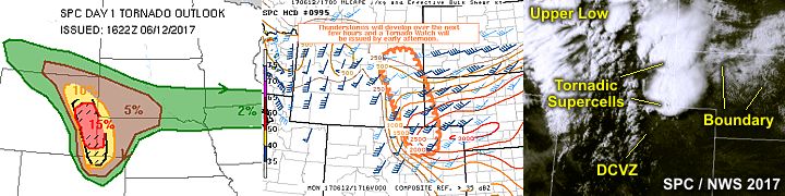
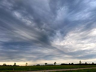
|
A sign of things to come ... Interesting cloud formations streaming over southwestern South Dakota on June 12, 2017. This is elevated / altocumulus type convection from the lead impulse ahead of a short-wave trough, signaling the arrival of upper level support for severe weather later that day. |
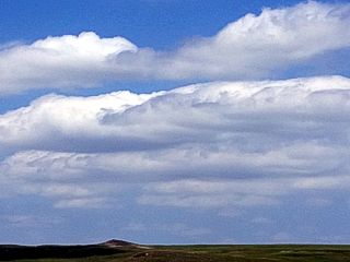
|
Horizontal convective rolls over eastern Wyoming during upslope wind flow and cumulus formation on June 12. The cap is still holding in place, and storms have not formed yet. |
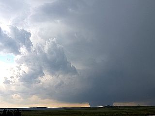
|
Rotating wall cloud on northern tornadic supercell coming into view near Fort Laramie, Wyoming. The view is to the southwest. |
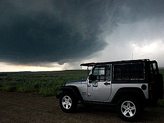
|
My vehicle and approaching supercell storm southwest of Fort Laramie, Wyoming. |
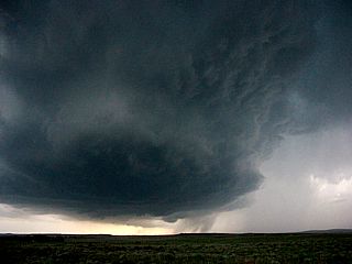
|
Supercell storm and hail shaft looking southwest of Fort Laramie, Wyoming. Softball sized hail was falling from this storm at the time. Note the developing tornadic circulation just below the center of the picture. |
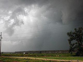
|
Stovepipe tornado barely visible through the rain west of Highway 85 and 26 near Lingle, Wyoming. The view is to the northwest. |
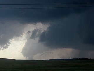
|
Former tornado occludes with impressive RFD, looking west of Highway 85, and new mesocyclone is developing to the right. |
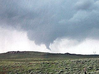
|
New tornado develops north of Lingle and west of Highway 85. |
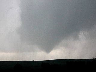
|
Tornado lifting west of Highway 85 and north of Lingle as the storm becomes HP and occludes again. |
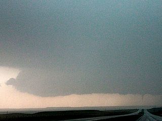
|
This is a view looking south towards Harrisburg, Nebraska on Highway 71. The last tornado of the southern supercell (with a long history of producing tornadoes from NE Colorado to Nebraska) can be seen to the lower right just above the road. |
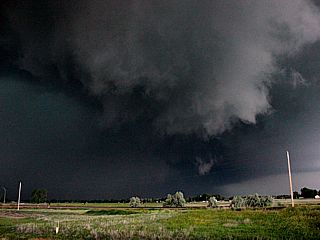
|
Cyclic supercell moving northwest of Bridgeport, Nebraska late on June 12 and crossing Highway 385. The storm is HP and becoming outflow dominant at this point. |
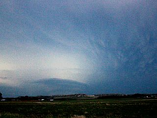
|
Distant view of the storm northeast of Bridgeport, Nebraska looking northward from Highway 26 at dusk. The supercell has a stacked plates presentation with frequent lightning and mammatus. |
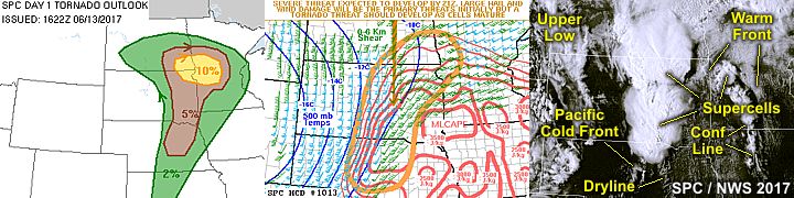
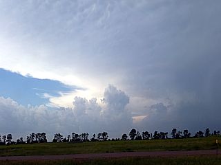
|
Approaching a supercell storm southwest of Plankington, South Dakota on June 13, 2017. The view is to the south off I-90 with the anvil blowoff overhead. |
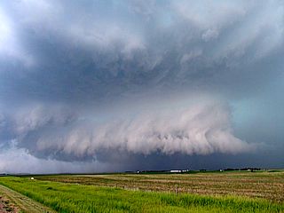
|
View of the HP supercell storm southwest of Plankington as it was intensifying. |
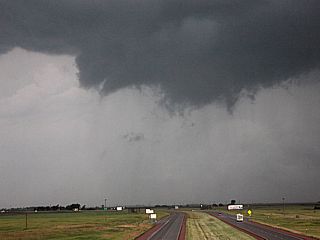
|
Storm produces and area of rotation with small funnels as it moves northeast and crosses I-90. |
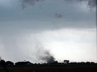
|
Gustnado near I-90 west of Mitchell, South Dakota as the HP storm becomes outflow dominant. |
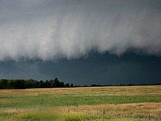
|
View into HP supercell storm with large rotating wall cloud / possible tornado just prior to rain wrapping near Stickney, South Dakota. The view is to the southwest. A major couplet was present on Doppler radar at the time (shown below). |
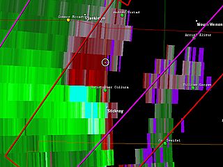
|
Impressive couplet on Doppler radar showing the area of rotation at the time the picture above was taken. |
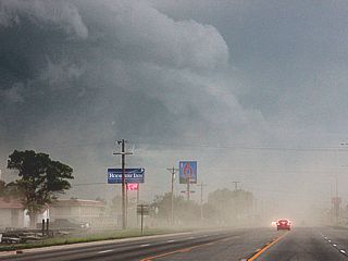
|
Outflow and blowing dust affecting Mitchell, South Dakota looking north on Highway 81 as the HP storm gusts out and evolves to a line segment with damaging winds along its gust front. |
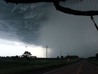
|
Hail shaft associated with a line segment of severe storms near Hutchinson County, South Dakota. The view is to the south. |
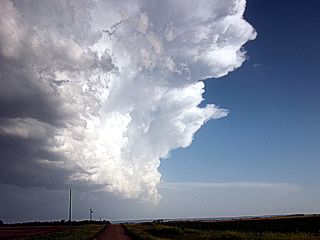
|
Anvil and view of the southern "tip" of the severe storm line segment west of Yankton, South Dakota late in the day on June 13. |
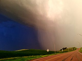
|
Intense portion of the line segment pushing through Cedar County, Nebraska near Bow Valley. The view is to the south and southeast, showing a prominent green-tinted hail shaft moving from right to left. |
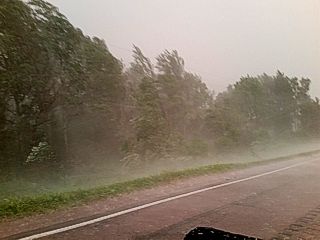
|
Severe conditions (winds over 60 MPH and large hail falling) near Bow Valley in Cedar County, Nebraska as the line segment intensifies after dark. This storm complex would make it to near Sioux City, Iowa leaving a swath of power outages and wind damage in its path. |
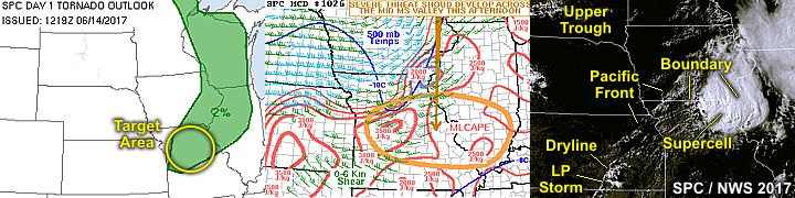
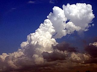
|
Convective initiation over north-central to northeastern Missouri during the afternoon of June 14, 2017. Note the tilting of the updraft tower due to the 40 knots of bulk shear in the 6km layer. |
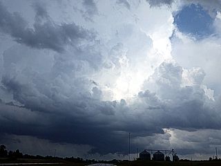
|
View of developing supercell storm near Marion County in Missouri from eastbound on Highway 36. Note the wall cloud in the lower portion of the picture. |
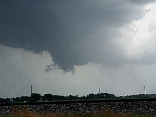
|
View of first of two small funnels developing on the developing supercell storm south of Hunnewell, Missouri over Marion County. |
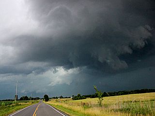
|
View of classic to HP supercell near Hunnewell, Missouri and Highway 36. Note the prominent RFD clear slot and funnel (second one produced by this storm) in the center of the photo. |
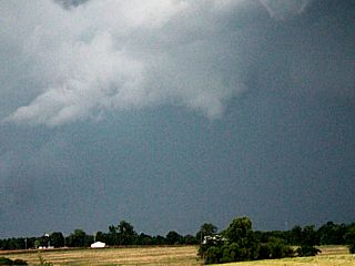
|
View of the small second funnel developing on the north side of a supercell storm's RFD slot north of Hunnewell, Missouri. |
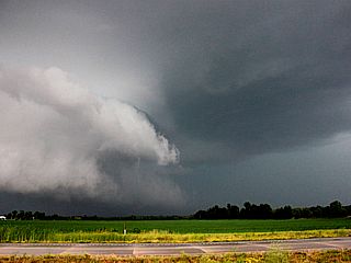
|
View of the storm evolving to HP mode as moisture increases with arrival of the low level jet. The view is to the north and northeast. |
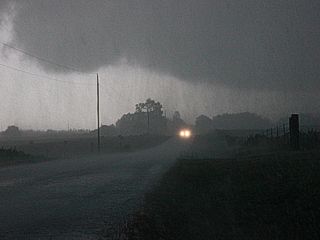
|
Severe winds and torrential rains looking south from behind the gust front north of Highway 36. |
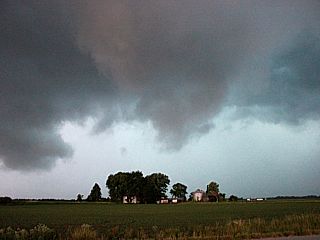
|
The storm produces and area of rotation again near Stoutsville, Missouri. The view is northward from Highway 24 with a brief funnel and rotating scud over a farmstead. The storm became outflow dominated after this and weakened. |
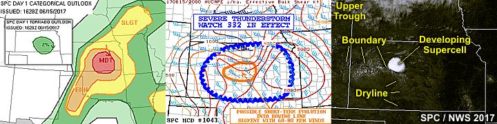
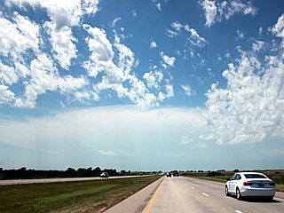
|
Racing westward on Interstate 70 to meet an early initiating supercell developing west of Russell, Kansas on June 15, 2017. The view is looking westward from west of Salina, Kansas. Note the ACCAS clouds overhead as well. |
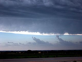
|
While approaching the storm from the east, and nearing Russell, Kansas, the view to the south reveals the anvil spreading overhead in the NW flow aloft, and lower clouds streaming into the intensifying supercell storm out of frame to the far right. |
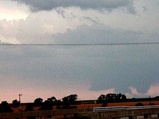
|
This was a brief tornado (lower right in this picture) that developed on the south side of the supercell storm. The tornado was confirmed by chaser Charles Edwards with his tour group at about the same time. The view is to the SW from I-70 east of Russell, Kansas. |
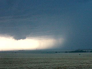
|
Small wall cloud on the southern side of the storm as it splits near LaCross, Kansas. Outflow can be seen undercutting the storm updraft as well. The view is to the west. |
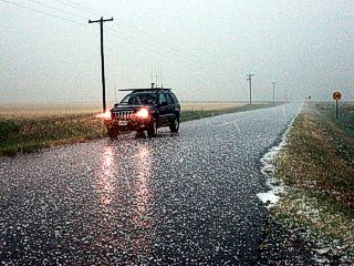
|
Hail being observed near LaCross, Kansas with many stones at least an inch in size covering the ground. Chaser Don Sanderson's vehicle is in this picture, who was also chasing with Dan Shaw that day. |
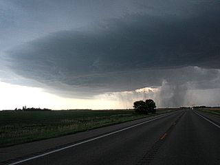
|
Another supercell develops near Saint John, Kansas late on June 15. This storm also produced very large hail, before evolving into a cluster of severe thunderstorms near Pratt, Kansas. |
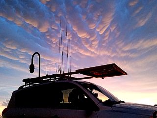
|
Chaser Dan Shaw's vehicle under an incredible display of mammatus clouds while wrapping up the chase north of Pratt, Kansas on SR 61 near dusk on June 15. |
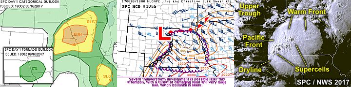
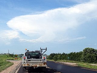
|
Heading north on SR 14 in Nebraska towards Albion during the afternoon of June 16, 2017. A supercell looms over the horizon while passing through a work zone on the way to the target area near Norfolk. |
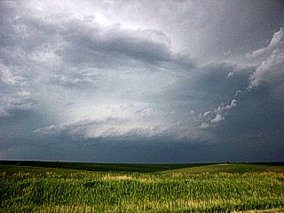
|
Here is the view of the supercell storm from the south between Albion and Madison, Nebraska from along SR 32. The storm is tornado warned at the time, and the start of a long day and night of severe weather. |
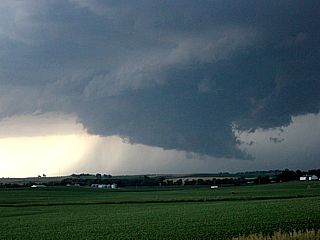
|
Developing wall cloud on the supercell storm northwest of Madison, Nebraska. |
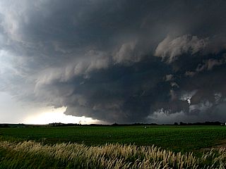
|
Large rotating wall cloud and supercell updraft just before getting undercut to the west of Madison, Nebraska. The view is to the west and northwest. |
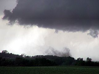
|
Brief "bird fart" tornado / gustnado under the rotating wall cloud to the west of Madison from along SR 121. The view is WNW. |
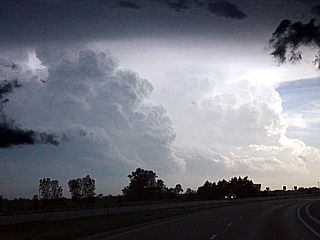
|
An LP supercell was on-going southwest of the main activity to the west of Lincoln, Nebraska all the while. In this view, from near Columbus, Nebraska and looking southwest, the LP storm has split into two separate LP supercells. |
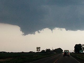
|
Small funnel cloud forms on a wall cloud associated with the southern split of the LP storm west of Lincoln, Nebraska late in the afternoon of June 16. This is just prior to a derecho producing storm cluster racing in from the north catching up with it. |
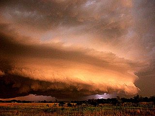
|
View of an intense HP supercell embedded in a derecho producing MCS of extreme damaging winds that will push across SE Nebraska and well into Kansas. The colors and lightning are impressive with the setting sun and cloud structure. This storm will produce winds exceeding 100 MPH. |
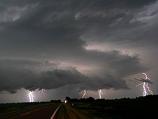
|
Cloud to ground (CG) lightning strikes to the northwest of Beatrice, Nebraska as the storm was intensifying and producing 80 to 100 MPH wind gusts. |
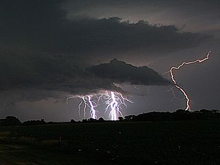
|
Another picture of the cloud to ground (CG) lightning strikes to the northwest of Beatrice. This storm had some of the most frequent lightning I ever seen in my life (at least 10 flashes per second)! |
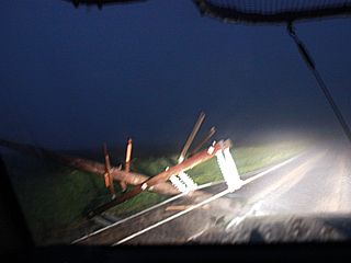
|
Numerous downed powerlines on a farm road to the west and northwest of Beatrice, Nebraska after dark on June 16. This was the only route to get into Beatrice, impossible without a 4x4. |
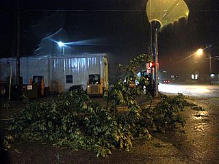
|
Downed trees, flooding, and wind damage in Beatrice, Nebraska during the late evening of June 16. |
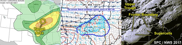
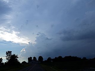
|
View approaching a supercell storm near Memphis, Missouri late in the afternoon of June 17, 2017. The storm will soon become undercut by outflow, as many storms did days prior. |
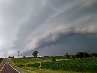
|
View of severe storm gust front to the west of Memphis, Missouri. |

|
Another view of the storm gust front about 10 miles south of Memphis, Missouri. Despite being outflow dominant and undercut, the supercell storm is still producing hail up to baseball sized. |
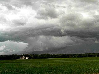
|
View of wall cloud and RFD region, still intact, after gust front passage and being undercut by the shallow layer of outflow air. The storm is still producing very large hail at the time. |
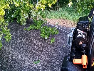
|
Using my vehicle winch to clear a tree from a blocked roadway after storms passed through on June 17 in NE Missouri. |
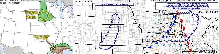
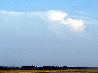
|
A small thunderstorm attempts to break through the strong cap to the southeast of Sioux Falls, SD during the late afternoon / evening of June 21, 2017. The area remained capped all day, with clear blue skies, and elevated storms to the far north over ND / western MN, or non-severe storms in far SW Nebraska. Basically I got a sunburn instead of seeing storms in the target area. |
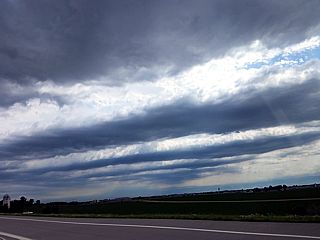
|
Impressive mid-level convective rolls streaming over southern Minnesota on June 22, 2017. This is associated with the southern edge of a powerful jet stream disturbance moving north of the area near the US / Canadian border. Unfortunately, this upper level support remained out of phase (well to the north) of the better low level moisture and instability (over Iowa) for severe storms. |
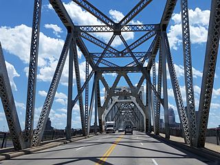
|
Driving back from Chicago to Florida, crossing over the Louisville, Kentucky bridge over the Ohio River during the early afternoon of June 25. |
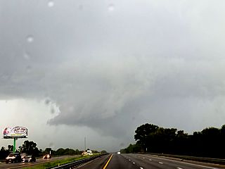
|
View of a (totally harmless) strong thunderstorm and shelf cloud north of Gainesville, Florida while heading south on I-75 late in the day of June 26. |
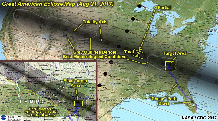
| CHASER NAME | HOME / BASE CITY | CALLSIGN | CHASE DATES | OCCUPATION |
| CHRIS COLLURA | DEERFIELD BEACH, FL | KG4PJN | 8-20 TO 8-22 | IT CONSULTANT |
| JEFFREY LAM | RIVERSIDE, CA | N/A | 8-20 TO 8-22 | CUSTOMER SERVICE |
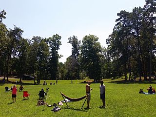
|
View of people gathering in the Foshee Recreation area to the southeast of Spring City, Tennessee. This area was chosen doe to a clear weather forecast and it being directly under the totality axis. |
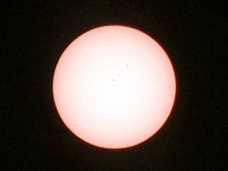
|
Filtered image of the full solar disk before first contact. Note the sunspots too. |
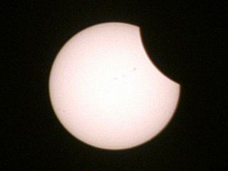
|
First contact as the moon begins to cross over the sun. The partial portion of the eclipse has begun. This was at about 1:40 EDT. |
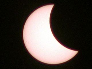
|
Filtered image of roughly half the sun covered by the moon. This was roughly 2 PM EDT. |
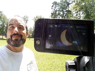
|
Myself with the camcorder taking video of the partial phase of the eclipse through solar filters. |
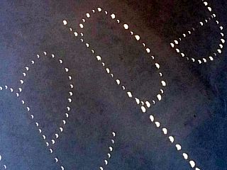
|
Another observer placed a bunch of pinholes on a cardboard sheet forming initials. These make a pinhole camera effect, with numerous images of the sun (in parital eclipse) cast on a sheet of paper. |

|
Sun about 75% blocked around 2:15 PM EDT. |
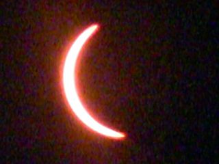
|
Approaching totality at about 2:25 PM EDT. |
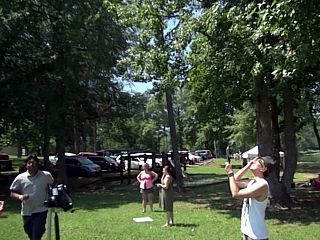
|
Folks at the campground in dimmed sunlight observing the approaching totality. |

|
Totality reached at about 2:32 PM EDT, and lasting about 2 minutes and 35 seconds. Beautiful corona and dark sky and stars visible. |
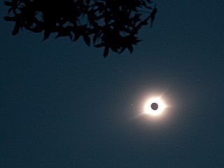
|
Wide angle view of the total eclipse and corona, showing the dark sky and silhouette of a tree overhead. |

|
Close-up of total eclipse showing corona and prominences around the edge of the solar disk. This was roughly 2:33 EDT. |
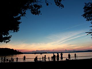
|
View looking north from the campground and across the lake in darkness - With twilight around the horizon making for a "360 degree sunset" as people watch. |

|
Silhouettes of observers marveling at the total eclipse in darkness at about 2:34 PM EDT. |

|
Totality ends at just before 2:35 EDT and the sun re-emerges from behind the moon. In this picture, the "diamond ring" effect can be seen, following the "bailey's beads". Wave shadows were also observed on the ground at this time. |
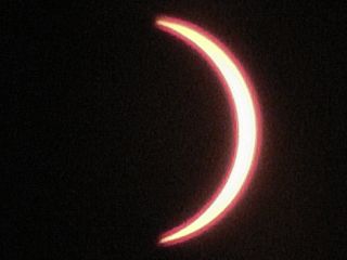
|
With the solar filters back in place, the sun is re-emerging back into a partial eclipse as we fall back into dim sunlight by 2:40 PM EDT. |
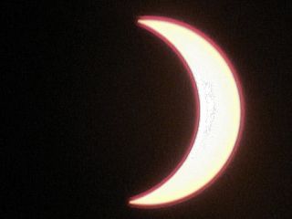
|
Partial eclipse as sun continues to emerge and gets brighter again by 2:50 PM EDT. |
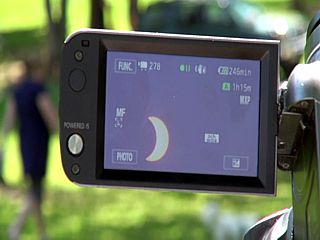
|
View of camera recording the eclipse through solar filters. |
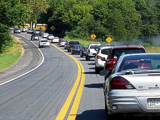
|
Traffic on a country road leaving the path of the eclipse totality line. Imagine leaving a rock concert - One stretching along a path 3,000 miles long and 30 miles wide? |
HTML File "mwcl2017.htm" - Developed By Chris Collura
To Return To The HOME Page Of This Site Click The "INDEX.HTM" Link Here!