
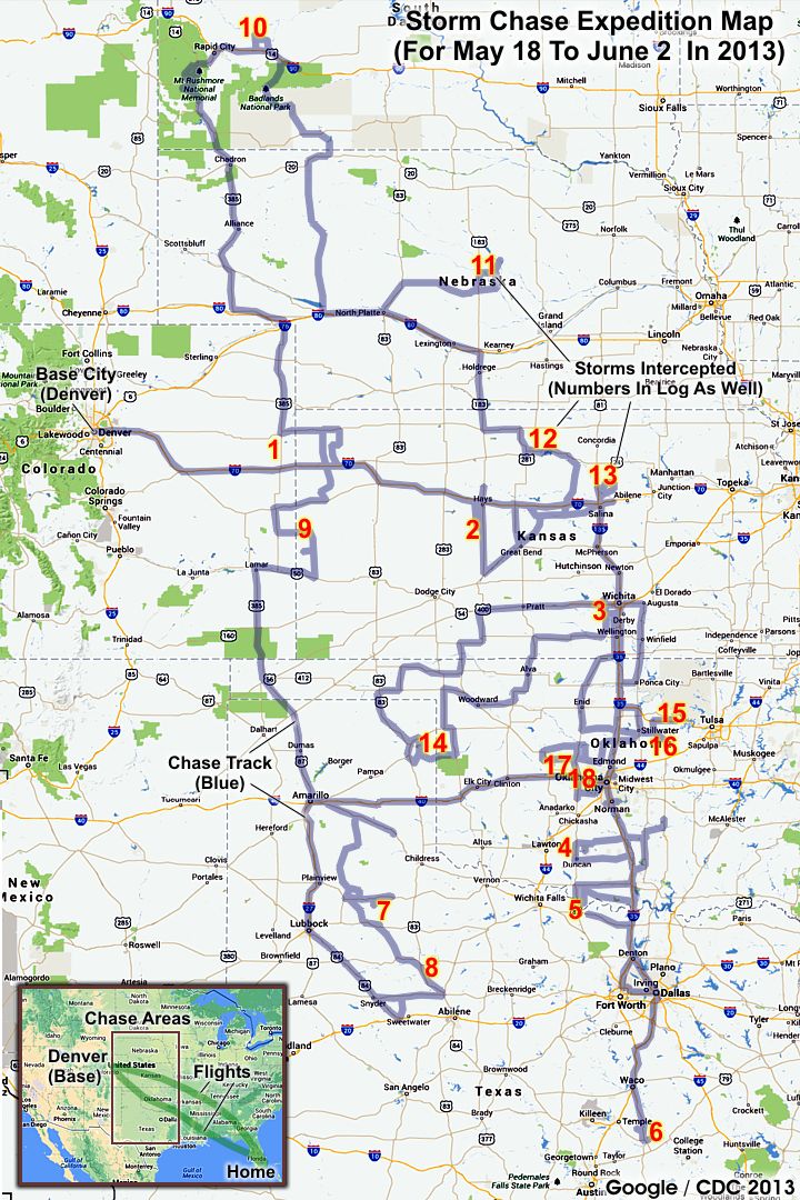
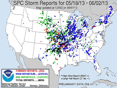
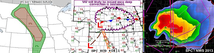
| This section is for storm chases done in the central / Midwestern United States during the year of 2013. This includes all storm chasing activities (including any major chase "expeditions") during the year of 2013 in the central USA (aka "Tornado Alley"). For 2013, all chases in the central USA will be logged in this section, with many of the chases being possible "spot" chases / major severe weather "setups" chased. Here you should find many pictures of lightning, tornadoes, hail, strong winds, along with many severe thunderstorm elements. Keep in mind that this chase log is scientific evidence and portrays my on-going storm chasing research. It has been placed on this page for easy reference and meteorological interests. Please do not plagiarize or copy this document to other sites for distribution. Note - This page may take a while to load on some SLOWER connections! |
STORM CHASING - CENTRAL UNITED STATES - TORNADO VICTIMS TRIBUTE

| CHASER NAME | HOME CITY | CALLSIGN | CHASE DATES | OCCUPATION |
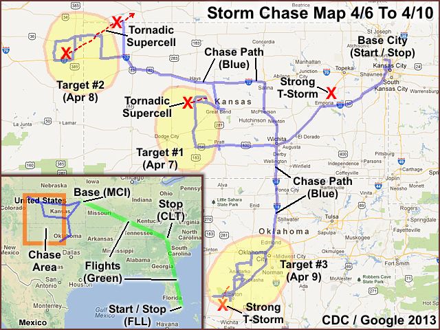
| CHRIS COLLURA | MIAMI, FL | KG4PJN | 4-6 TO 4-10 | IT CONSULTANT |
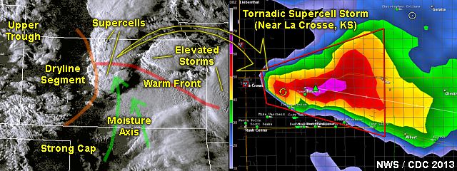
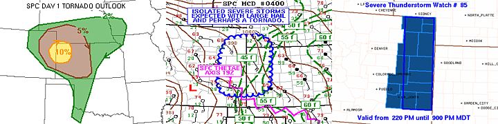
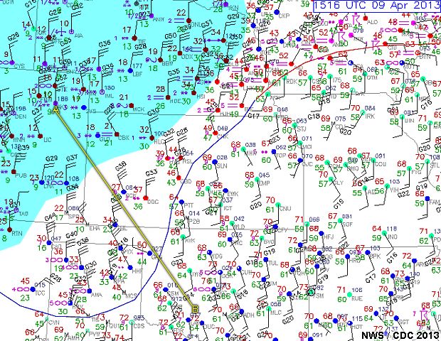
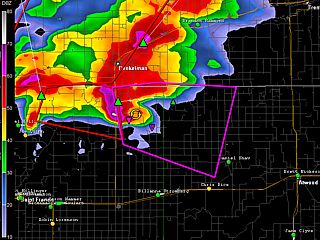
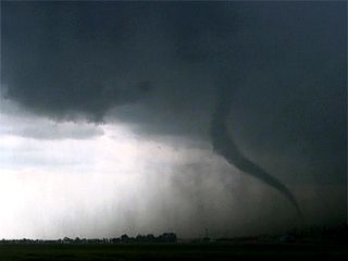
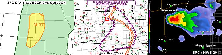
1). April 7, 6:00 PM - Observation and interception of a very severe (and tornadic) thunderstorm near La Cross, Kansas and east to near Otis and Olmitz / Albert, and in Rush / Barton counties, from along Highway 183 and eastward along Highways 96 to 281. The storm was a supercell storm. Conditions observed were heavy rains, hail up to golfball sized, frequent lightning, and 50 MPH winds. The storm core was indirectly penetrated, with a diversion north of La Crosse and east around the storm to avoid larger hail. A very weak and brief tornado was also observed with this storm near Otis, Kansas. No damage was noted. Conditions causing the storm were surface heating, an upper trough, and an advancing dryline / surface low. Documentation was digital video, digital still photos, and audio. A 2011 Chevy Aveo was used to chase the storms. A severe thunderstorm watch was also in effect for the area, valid until 12 AM CDT.
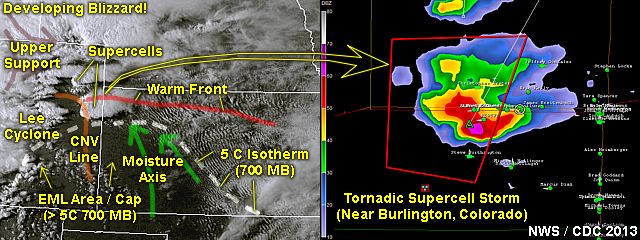
2). April 8, 7:00 PM - Observation and interception of a very severe (and tornadic) thunderstorm near Burlington, Colorado in Kit Carson County north of I-70 and west of Highway 385 and points east and northeastward to near Saint Francis, Kansas along Highway 36 into Cheyenne County, then eventually into Nebraska near Trenton in Hitchcock County (heading north on Highway 25 north of Atwood, Kansas). The storm was a supercell storm, and first produced a landspout type tornado north of Burlington, CO and southwest of Saint Francis, Kansas. The core of this storm was not directly penetrated. The storm rapidly intensified again later near and west of Trenton, NE withy tornado damage reported later. This tornado was not visible (after dark) but 60+ MPH inflow winds were observed with this storm, with airborne dust and farm vegetation. These strong SE inflow winds gave way to a dusty calm then rapid wind shift to westerly (RFD)! Otherwise, hail up to 1", heavy rains, and frequent lightning was observed with this storm. Visually, this supercell storm had an impressive visual presentation (stacked-plates or "mothership" / striated structure) with inflow banding. Conditions casing the storms were upslope winds, surface heating, a low pressure system, and upper trough. A 2011 Chevy Aveo was used to chase the storms. Documentation was digital images and video, as well as audio. A severe thunderstorm watch was also in effect for this area until 9 PM MDT (10 Central).
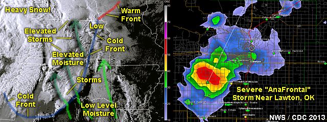
3). April 9, 6:00 PM - Observation and interception of a strong thunderstorm near Lawton, Oklahoma in Comanche County from near and west of I-44 and Highway 62. The storm was a small supercell storm, but was elevated as it was undercut by an advancing arctic cold front / cool density current. Most convection, although marginally severe, happeed BEHIND the cold front (anafrontal) with a shallow layer of cold air undercutting the storms. The strong cold front had a temperature change as much as 60 degrees F, over a 6 hour period! In fact, the same area in Colorado the day prior (near Burlington), the temperature was a mere 15-20 degrees F with heavy snow, a far cry from 75 degrees 12 hours earlier! The Lawton storm had small hail, lightning, 40 MPH winds, and heavy rains. Conditions causing the storm were surface heating, an upper trough, and an advancing strong cold front. Documentation was digital still photos. A 2011 Chevy Aveo was used to chase the storms. A severe thunderstorm watch was also in effect for the area, valid until 1 AM CDT.
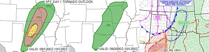
4). April 9, 10:00 PM - Observation of strong thunderstorms from near Wichita, Kansas in Sedgwick County from I-35 and I-44 and points northeastward to near Emporia, Kansas in Lyon County. The storms were multicell clusters of strong thunderstorms, developing in the unstable post-frontal environment. Winds gisting over 40 MPH, frequent lightning, small hail, and heavy rains were onserved with these storms. These elevated storms were encountered with surface temperatures in the low 40's, enroute to Kansas City, MO after wrapping up the chase trip. Conditions causing the storm were an elevated warm air layer, an upper trough, and an advancing strong cold front. Documentation was digital video. A 2011 Chevy Aveo was used to chase the storms. A severe thunderstorm watch was also in effect for the area, valid until 1 AM CDT.
This concludes the Chase Log for the central US Plains and Midwest (tornado alley) chase trip from April 6 through April 10, 2013. The summary includes a total of 2 severe and 2 strong thunderstorms with 2 separate (weak) tornadoes. The main chase vehicle conducting all chases was a 2011 Chevy Aveo. This information was prepared exclusively for the National Weather service and the team of Skywarn storm spotters.
|
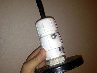
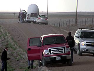
TSA really freaked out when seeing this antenna mount I slapped together at the last minute. It's PVC and allows easy mounting on any vehicle or my weather station (for hurricanes). It was enough to close the security lane and bring in some "investigators" from TSA's Elite Staff - They even took photos of it! When it was just an antenna mount, things re-opened (after 20 minutes) and moved on. Luckily US Air (FLL to Kansas City) was not crowded! |
|
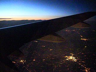
Overflying St Louis, MO (with sunset and city lights below) enroute to Kansas City on April 6. |
|
Verne Carlson? just east of Greensburg, Kasnas on April 7, just before heading north on 183. |
|
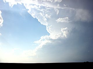
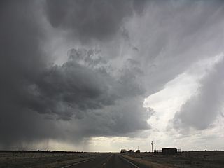
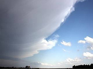
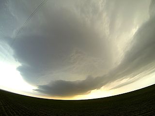
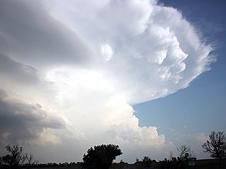
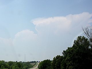
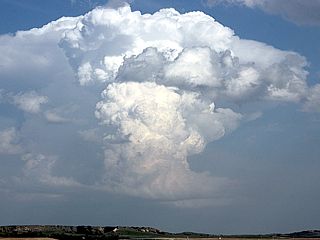
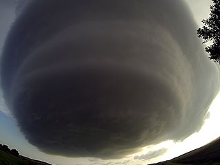
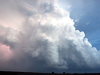
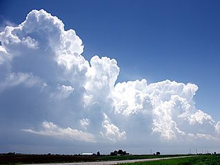
Developing supercell storm in Kansas on April 7, 2013. |
|
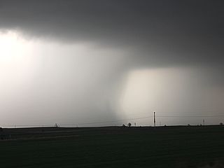
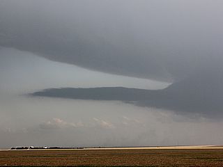
LP supercell storm struggling south of a more powerful storm on April 7 (Kansas). |
|
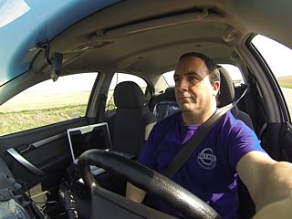
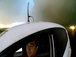
Myself driving towards the Kansas target on April 7. |
|
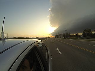
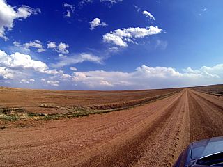
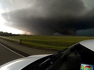
Heading towards the storm! This is north on highway 183 on April 7 (Kansas). |
|
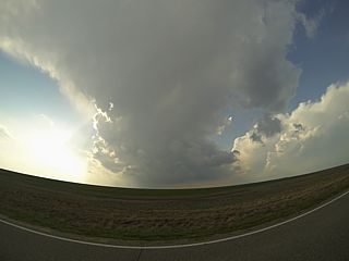
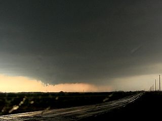
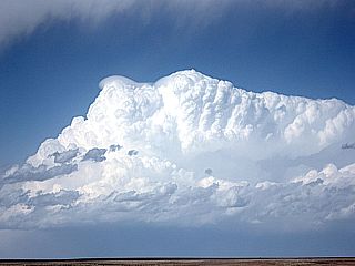
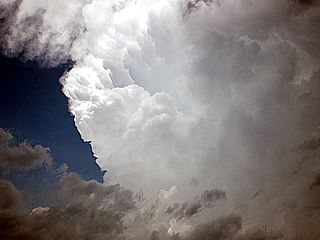
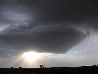
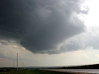
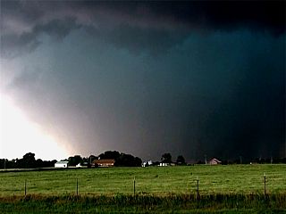
Supercell storm updraft base "trying" near Otis, Kansas (April 7, 2013). |
|
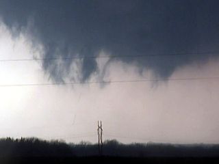
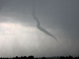
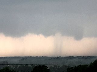
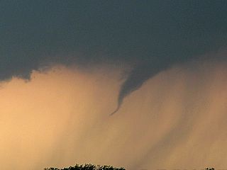
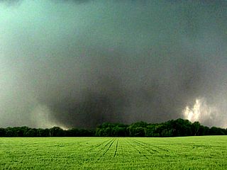
Probably the smallest and thinnest tornado I ever seen - Kasnas on April 7. |
|
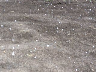
Lots of golfball sized hail falling from the storm near Otis, KS (April 7, 2013). |
|
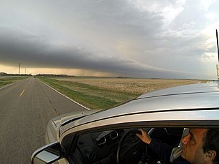
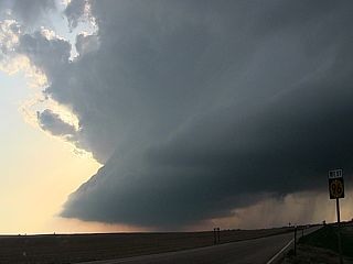
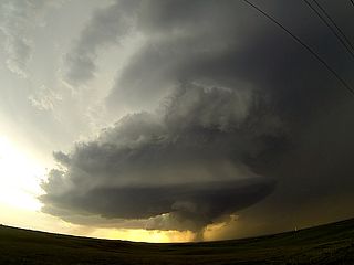
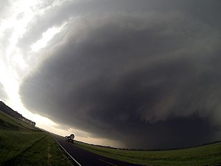
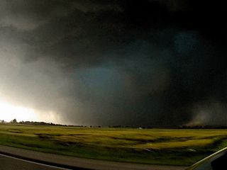
Storm structure - KS (April 7, 2013). |
|
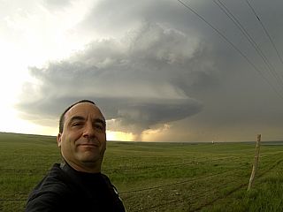
Wide shot of myself driving and supercell updraft / RFD section - Kansas (April 7, 2013). |
|
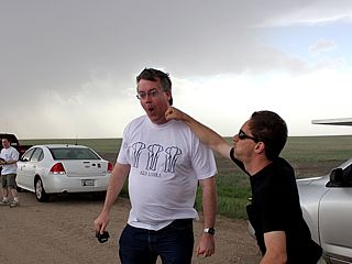
Chaser J Gustino after dark in Kasnas photographing a dying supercell storm. |
|
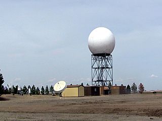
NWS radar in Goodland, Kasnas on April 8. |
|
Developing supercell storm (left moving) on April 8 (NE Colorado). |
|
Driving in open coutry - NE Colorado (April 8). |
|
Developing supercell in NE Colorado - April 8, 2013. |
|
Roger Hill?'s tour group on April 8, 2013 near Burlington, CO under a developing supercell storm. |
|
Supercell near Burlington, Colorado - April 8, 2013. |
|
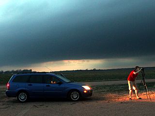
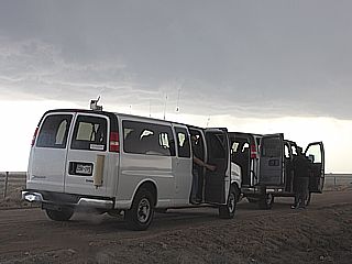
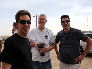
Storm chasers / researchers - Near Burlington, CO on April 8. |
|
Anvil and shadow of supercell near Burlington, Colorado - April 8, 2013. |
|
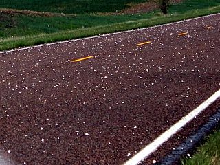
Nickel to quarter sized hail - NE Colorado on April 8. |
|
Beaver's tail of supercell near Burlington, Colorado - April 8, 2013. |
|
Supercell SW of Saint Frances, Kansas - April 8, 2013. |
|
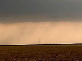
Brief landspout tornado northeast of Burlington, Colorado - April 8, 2013. |
|
Supercell storm (and green hail core to right) NW of Burlington, CO on April 8. |
|
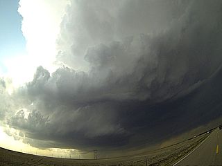
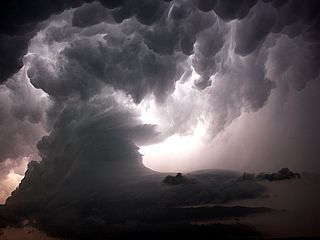
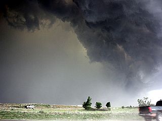
Tornadic supercell storm near NE / KS border - April 8, 2013 (N of Atwood, KS) ... Amazing inflow features. |
|
Radar image of violent (tornadic) supercell storm in NW Kansas and nearing SW Nebraska after dark on April 8 (NWS radar reflectivity image from Goodland). |
|
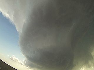
Tornadic supercell storm near NE / KS border (April 8) with very strong inflow with blowing dust and airborne corn husks / leaves. |
|
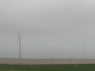
Low stratus and cold fog on the morning of April 9 near Russel, Kansas. Wind turbines "in the clouds". |
|
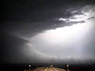
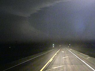
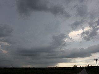
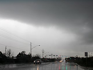
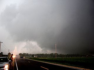
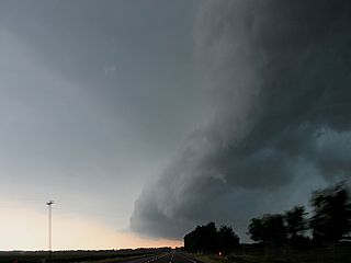
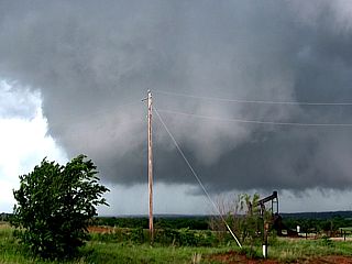
Supercell storm being undercut by surging cold front near Lawton, OK on April 9. |
|
Wet RFD near Lawton, OK on April 9. |

|
April 9 west of Lawton, OK - Undercutting and surging cold front makes for a bust (sort of)! |
|
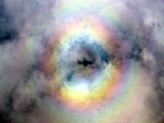
Pilot's glory above deck of clouds after leaving Kansas City on Apr 10 (this was above the system producing tornadoes later that day). |
| CHASER NAME | HOME CITY | CALLSIGN | CHASE DATES | OCCUPATION |
| CHRIS COLLURA | MIAMI, FL | KG4PJN | 5-18 TO 6-2 | IT CONSULTANT |
1). May 18, 4:30 PM - Observation and indirect penetration of a severe thunderstorm west of Burlington, Colorado in Kit Carson County and along Interstate 70. The storm was a high based LP supercell storm, being passed on its northern fringes en-route to a Kansas target area. The storm split and for a while had a bell-shaped base, RFD feature, and striations on the updraft tower. Hail to dime sized was observed with this storm, along with 40 MPH winds, rain, and frequent lightning. The main core was not penetrated. Conditions causing the storm were an upper-level trough, developing lee cyclone, and surface heating. A 2013 Kia Sportage was used to chase the storm. Documentation was digital stills and HD video. A tornado watch was also valid for this area until 11 PM CDT.
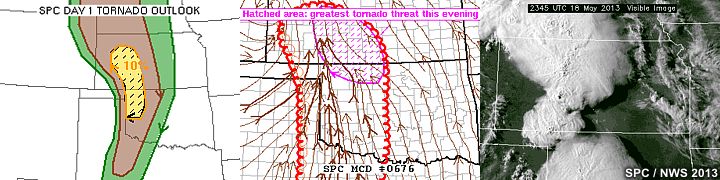
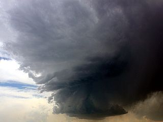
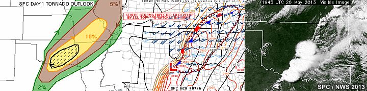
2). May 18, 6:30 PM - Observation and interception of a very severe and tornadic thunderstorm from south of Ellis, Kansas into Rush County near Ellis Avenue and around Highway 183 to west of La Crosse. The storm was an HP supercell storm, which produced a well-defined but poorly contrasted funnel / tornado during its northern split with the southern split also producing a weak tornado (dust rotating under funnel / rotating wall cloud) north of Nekoma. This HP supercell was part of two tornadic supercells, with the next storm to the south producing a significant tornado (too far to intercept at this point after long drive from Denver). The HP supercell storm here had hail to baseball sized (core not penetrated directly). Hail to 1", winds gusting near 80 MPH (especially in RFD), frequent lightning with some close hits, and torrential rain was observed. Conditions causing the storms were a dryline, surface heating, low pressure trough, and upper trough. Documentation was audio, HD video and digital stills. A 2013 Kia Sportage was used to chase the storm. A tornado watch was also valid for this area until 11 PM CDT.
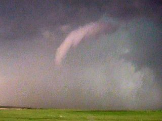
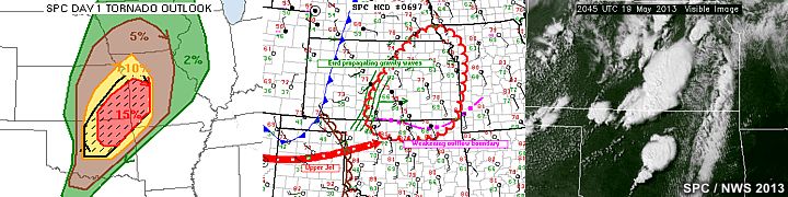
3). May 19, 4:30 PM - Interception of an extremely severe and tornadic thunderstorm to the southwest of Wichita, Kansas in Sedgwick County. The storm was south of Highway 400 / 54 and the storm was followed to the NE from near Highway 42 and Clearwater and into the SW side of Wichita near McConnel Air Force Base. Two tornadoes were observed with this storm. The first one was a slender elephant trunk / rope tornado that lasted about 5 minutes on the south side of the developing storm, and another farther north as a wide / multi vortex that quickly became rain wrapped. The storm was a powerful HP supercell. The storm core, containing hail at least baseball sized, was not penetrated. Conditions encountered included winds gusting 70 to even 80 MPH (in the rain wrap / wet RFD), hail to golfball sized, frequent lightning, and torrential rains. Damage occurred in parts of Wichita from this storm. Conditions causing the storms were a weak cold front, dryline / boundary interactions, upper trough, surface heating, and surface low pressure. Documentation was digital stills, HD video, and audio. A 2013 Kia Sportage was used to chase the storms. A tornado watch was also in effect for this area until 10 PM CDT.
4). May 20, 4:30 PM - Observation and penetration of an extremely severe and violent tornadic thunderstorm from near Duncan, Oklahoma in Stephens County from near Highway 81 and State Road 7 and points east and northeast. The storm was followed from initiation, and split into two storms, with the right split the one being followed. The left split of the supercell, however, went on to become the devastating Moore, Oklahoma tornado. These storms were classic / HP supercell storms. This tornado was not intercepted as it was in a heavily populated area. The southern split produced a rotating wall cloud with some funnels and a brief tornado. Other conditions with this storm were golfball sized hail, 60 MPH winds, torrential rain, and frequent lightning with many close hits. Conditions causing the storms were boundary interactions, a weak cold front, surface heating, dryline, and an upper trough. A 2013 Kia Sportage was used to chase the storms. Documentation was digital stills, audio, and HD video. A tornado watch was also in effect for the area until 10 PM CDT.
5). May 20, 6:30 PM - Observation of a severe thunderstorm from north of Courtney, Oklahoma in Love County and points southward to near Montague County in Texas near Saint Jo and along Highways 70 and 82. The storm was an HP supercell that evolved to a multicell cluster of strong and severe storms. The storm was outflow dominant, and had winds gusting near 70 MPH with frequent lightning, torrential / horizontal rains, and hail up to 1". Conditions causing the storms were boundary interactions, surface heating, dryline, and an upper trough. A 2013 Kia Sportage was used to chase the storms. Documentation was digital stills, audio, and HD video. A tornado watch was also in effect for the area until 10 PM CDT.
6). May 21, 0:00 PM - Penetration of strong and severe thunderstorms along a long line / path from near Waco, Texas and southward to near Rosebud, Texas along Interstate 35 as well as Highway 77. The thunderstorms were a multicell line of strong and severe thunderstorms with an HP supercell storm at the southern end of the line. The storms were very outflow dominant. Conditions observed with the storms were winds gusting up to 60 MPH, torrential rains, hail to a half-inch, and frequent lightning with close hits. Conditions causing the storms were outflow boundaries, surface heating, and a cold front. A 2013 Kia Sportage was used to chase the storms. Documentation was audio, HD video, and digital stills. A tornado watch was also valid for the area until 7 PM CDT.
7). May 23, 3:00 PM - Interception and penetration of a very severe and tornadic thunderstorm from Floyd County near Dougherty, Texas and west of Highways 70 and near Highway 62. The storm was an HP supercell storm that produced some weak tornadoes (one of which was observed). The storm was followed southward to near McAdoo, Texas before it became outflow dominated. In addition to the weak tornado, very strong winds over 70 MPH (with blowing dust), frequent lightning, golfball sized hail, and torrential rains were observed with this storm. Conditions causing the storms were an outflow boundary, low pressure trough, surface heating, and upslope wind flow. Documentation was digital stills and HD video. A 2013 Kia Sportage was used to chase the storms. A tornado watch was also valid for the area until 10 PM CDT
8). May 23, 5:00 PM - Interception and penetration of another extremely severe and tornadic thunderstorm from near Spur (Dickens County) through Jayton, Texas (Kent County) and southward through Rotan and Fisher Counties primarily along Highway 70 and parts of Highway 380. The storm was another HP supercell storm. A tornado was observed with this storm near Rotan in Fisher County from along Highway 70. The storm had XDW (extreme damaging winds), and these winds, near Jayton and Highway 380, were observed gusting over 100 MPH! Hail up to golfball sized, torrential / violent rain, and frequent lightning was also observed with this storm. The storm also caused flash flooding and structural damage to buildings (some roofs torn off). Conditions causing the storms were an outflow boundary, low pressure trough, surface heating, and upslope wind flow. Documentation was digital stills and HD video. A 2013 Kia Sportage was used to chase the storms. A tornado watch was also valid for the area until 10 PM CDT
9). May 24, 6:00 PM - Interception and penetration of a very severe thunderstorm from near Sheridan Lake in Kiowa / Cheyenne counties in Colorado and near Highways 385 and 40. The storm was followed into Kansas to near Goodland and I-70 / Highway 27 in Wallace / Sherman counties. The storm was an LP supercell storm. Conditions encountered were lightning (with close hits), large hail (up to 2" was observed), light to moderate rains, and winds near 50 MPH (mainly inflow with dust). Some small funnel clouds were observed, and the storm had a striking visual appearance of stacked plates at one point. Conditions causing the storms were a dryline, surface heating, low pressure area, and an upper trough. Documentation was audio, digital stills, and HD video. A 2013 Kia Sportage was used to chase the storms. A severe thunderstorm watch was also in effect for the area until 10 PM CDT.
10). May 25, 8:00 PM - Interception and observation of a very severe thunderstorm in Meade County, South Dakota north of I-90 and near CR MC-29 and Viewfield. The storm was a classic supercell storm, with a very striking and impressive visual appearance (barber-pole updraft and stacked-plates appearance). The storm core was not penetrated, and contained 3" hail to baseball sized. Conditions encountered were 40-MPH winds, lightning, moderate rain, and hail to 3/4" (the storm core was avoided). Some funnel clouds were also observed with this storm, with a well-developed RFD. The storms were caused by surface heating, a warm front / dryline interaction, a low pressure area, and an upper trough. Documentation was digital stills and HD video. A 2013 Kia Sportage was used to chase the storms. A tornado watch was also valid for the area until 10 PM MDT.
11). May 26, 7:30 PM - Interception and observation of a very severe thunderstorm from near Broken Bow to Comstock, Nebraska in Custer County and near Highway 183 and State Road 70. The storm was a very intense LP supercell, evolving to classic mode. The storm had an incredible visual appearance, with a striking barber-pole updraft and "stacked plates" / "flying saucer" effect. The storm produced baseball sized hail, but the dangerous core was only indirectly penetrated, and hail up to 1" was observed falling. Some partially melted baseball (melted to tennis ball sized) hailstones were noted on the ground behind the storm core. Other conditions encountered were light rain, 40 MPH inflow winds, and frequent lightning with some close hits. The storm also produced a rotating wall cloud with funnels. The storms were caused by a low pressure area, surface heating, warm-front (well ahead of a weak dryline), and upper trough. A 2013 Kia Sportage was used to chase the storm. Documentation of this storm was digital stills, audio, and HD video. A tornado watch was also in effect for the area until 2 AM CDT.
12). May 27, 7:00 PM - Observation of a severe thunderstorm in Osborne County, Kansas from near Osborne, Kansas and eastward through Beloit. The storm was a supercell storm. A rotating wall cloud with funnels was observed with this storm, along with hail to 1", moderate rains, 50 MPH inflow winds, and frequent lightning. The storm was caused by a warm front, surface heating, upper trough, low pressure area, and dryline. A 2013 Kia Sportage was used to chase the storms. Documentation was audio, digital stills, and HD video. A tornado watch was also in effect for the area until 12 AM CDT.
13). May 28, 6:00 PM - Interception, indirect penetration, and observation of an extremely severe and violent tornadic thunderstorm to the north of Salina, Kansas in Ottawa County from near Highway 81 and State Road 143. The storm was a tornadic classic (evolving to HP) cyclic supercell storm. The storm produced two tornadoes, the first one short lived, and the second being a large and potentially violent wedge tornado, with a wide of a mile wide at one point, and staying on the ground for at least 30 minutes until the wet RFD wrapped around it, obscuring it from view. In addition to the tornado, 50 to 60 MPH inflow winds were noted, large hail up to tennis ball sized, torrential (horizontal) rains, and very frequent lightning with many close hits. Damage occurred over open country (mainly to farm equipment and powerlines) from this tornado, as it fortunately did not hit any towns. Conditions causing the storm were an outflow boundary, stationary front, dryline, surface heating, low pressure area, and an upper trough. A 2013 Kia Sportage was used to chase the storm. Documentation was digital stills, audio, streaming video, and HD video. A tornado watch was also in effect for the area until 10 PM CDT.
14). May 29, 4:30 PM - Indirect penetration and observation of a severe thunderstorm near Briscoe, Texas and eastward along Highway 83 and FM 1046 and FM 277 in Hemphill County. The storm was a bow segment in a multicell line of severe thunderstorms. The core was not directly penetrated, but hail to 3/4", 60 to 70 MPH winds (and blowing dust), frequent lightning (with some close hits), and heavy rains were encountered. The storm core contained hail over 2" (core not directly penetrated). Conditions causing the storms were surface heating, a dryline, a low pressure trough, and an upper trough. A 2013 Kia Sportage was used to chase the storms. Documentation was digital stills and HD video. A tornado watch was also valid for the area until 10 PM CDT.
15). May 30, 3:30 PM - Observation and indirect penetration of a very severe and tornadic thunderstorm from near Guthrie, Oklahoma in Logan and Payne Counties, and east and northeast through Perkins and Cushing near State Road 33 / 105 and Highway 177. The storm was a supercell storm, and two small brief tornadoes were observed before outflow undercut the storm. The storm had large hail in its main core (not penetrated), but a golfball sized stone or two hit the vehicle. Heavy rains, 50 MPH winds, and frequent lightning (with some close hits) were observed with this storm. The storm was caused by surface heating, an outflow boundary, low pressure area, and upper trough. A 2013 Kia Sportage was used to chase the storms. Documentation was digital stills, audio, and HD video. A tornado watch was also valid for the area until 10 PM CDT.
16). May 30, 5:30 PM - Observation of a severe thunderstorm from near Guthrie, Oklahoma in Logan and Payne Counties, and eastward towards Agra near Highway 177 and State Road 105. The storm was a supercell storm, and came very close to producing a tornado, with a rapidly rotating wall cloud and funnel across SR 105. The storm quickly succumbed to the effects of the outflow boundary after that, but not before exhibiting an impressive structure with striations and barber-pole updraft. The core contained large hail (over 2") but the core was not penetrated. 50 MPH winds and lightning were observed with this storm in addition to the rotation and funnel. The storm was caused by surface heating, dryline, an outflow boundary, low pressure area, and upper trough. A 2013 Kia Sportage was used to chase the storms. Documentation was digital stills and HD video. A tornado watch was also valid for the area until 10 PM CDT.
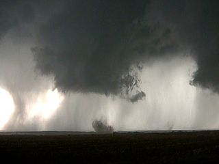
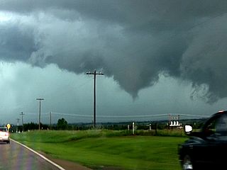
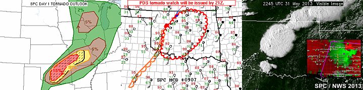
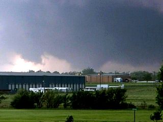
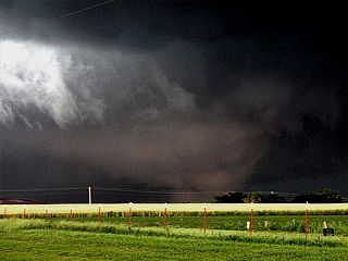
17). May 31, 6:00 PM - Interception, observation, and penetration of an extremely severe and violent tornadic thunderstorm (of "historic" proportions) near and to the south of El Reno, Oklahoma in Canadian County. The storm was a violent classic / HP cyclic supercell storm, and produced at least three tornadoes (most of these being mile-wide multi-vortex / wedge type). The storm also contained grapefruit sized hail and 100 MPH winds in addition to heavy rains and tornadoes. The main core was avoided like the plague. Conditions encountered during this storm were winds over 100 MPH (tornadic inflow and RFD), frequent lightning with close hits, hail to baseball sized, and extremely heavy (horizontal) rains. The storm caused damage and deaths in El Reno, including those of renowned scientists / storm chasers Tim Samaras, his son Paul, and Carl Young. The large tornadoes were observed with this cyclic supercell, along with a very impressive striated updraft, wall cloud, inflow bands, RFD clear-slot, and supercell structure. The tornadoes were all wedge tornadoes / multi vortex, a mile wide in some cases. Later analysis shows these 'mile wide' tornadoes being mere sub vortices of a larger circulation 2.6 MILES wide! The tornado was rated EF-5 with a core (peak-gust) velocity of 296 MPH! The outer circulation of the third wedge tornado (during its development stages) passed very close to, if not over, the chase vehicle (nearly blowing it off the road). Other storm chasers had their vehicles destroyed from this storm. Conditions causing the storms were surface heating, low pressure area, a dryline, stationary frontal boundary, and strong upper trough. A 2013 Kia Sportage was used to chase the storms. Documentation was digital stills, audio, and HD video. A PDS (particularly dangerous situation) tornado watch was also valid for the area until 12 AM CDT.
18). May 31, 7:30 PM - Observation and penetration of another very severe and tornadic thunderstorm from near Mustang, OK in Canadian County and eastward to Will Rogers International Airport in Oklahoma County along State Road 152. The storm was an HP supercell storm, and took a direct hit on the town of Mustang. While in traffic, with people panicking, a car struck me in the middle turning lane damaging my front passenger door and wheel, destroying the tire. After that, the other motorist left and I was forced to retreat behind a church / gas station before the storm hit. I never saw the person who cut in front of me again. The vehicle could only do 20 MPH after quickly changing the spare tire. A tornadic circulation passed over my vicinity, and had gusts near 80 MPH with flying debris and power poles / signs down. This HP supercell evolved into a very large cluster of severe thunderstorms. Other conditions encountered were 80 MPH winds, hail to golfball sized, frequent lightning, and torrential rains. I had to "limp" to the airport to take shelter during the storm in their parking garage. After finding out I could not get any help from their car rental facility (power out and not same company / franchise), I had to hobble 10 miles to a motel off I-44 in heavy rains, flash flooding (cars were floating in rushing water in some streets), and hail to golfball sized. The storm ended after arriving at the motel off I-44 and Penn in NE Oklahoma City. Many trees down, power outages, and flash flooding were observed with this storm. Conditions causing the storms were surface heating, low pressure area, a stationary frontal boundary, and strong upper trough. A 2013 Kia Sportage was used to chase the storms and sustained damage (from the accident in Mustang). Documentation was digital stills and HD video. A tornado watch was also valid for the area until 12 AM CDT.
This concludes the Chase Log for the central US Plains and Midwest (tornado alley) main 2013 chase trip from May 18 through June 2. The summary includes a total of 17 severe thunderstorms and at least 15 tornadoes, four of which being significant. The main chase vehicle conducting all chases was a 2013 Kia Sportage, later changed at the conclusion of the chase to another 2012 Kia Sportage after the former was damaged in Mustang, Oklahoma by a motorist fleeing from the storms on May 31. This information was prepared exclusively for the National Weather service and the team of Skywarn storm spotters.
|
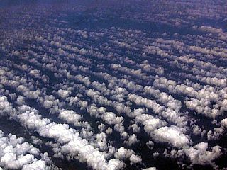
Flying out (from Fort Lauderdale, Florida to Denver, Colorado) and across the Gulf of Mexico on May 18, 2013. Note the cloud "streets" over the wam Gulf waters, denoting a long and persistant "fetch" of moisture into the Texas area ... A subtle sign of "things to come" in the central USA, as most moisture is from the Gulf of Mexico for severe weather. This was taken from a Boeing 737 at an altitude of about 38,000 feet. |
|
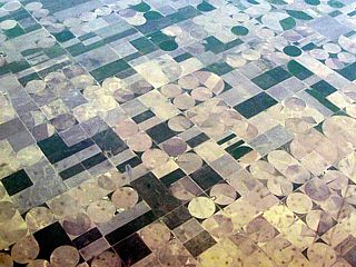
Another view taken from a Boeing 737 (from Fort Lauderdale, Florida to Denver, Colorado) at an altitude of about 38,000 feet over Kansas on May 18, 2013. The flat terrain is marked by numerous circular fields, where center point irrigation is widely used. |
|
Explosive supercell development over eastern Colorado / Western Kansas on May 18, 2013. |
|
Small LP (low precipitaion) supercell storm near Burlington, Colorado on May 18, 2013. |
|
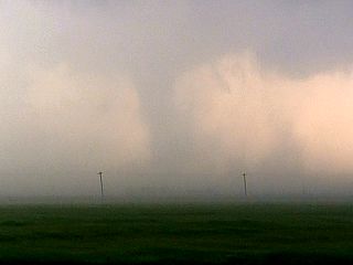
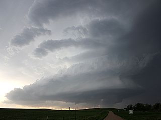
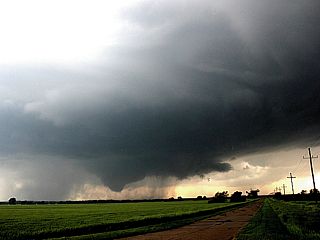
Tornado on northern HP (high precipition) supercell to the SW of Hays, Kansas on May 18, 2013. The view is to the West. |
|
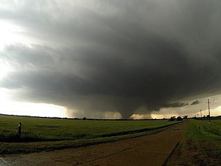
Second tornado / rapidly rotating wall cloud on northern HP supercell to the SW of Hays, Kansas on May 18, 2013. The view is WSW. |
|
Tornado number one of the supercell south of Wichita, Kansas (near Viola) on May 19, 2013. The view is South. |
|
Closer / enhanced view of the tornado near Viola, Kansas on May 19, 2013. The view is South. |
|
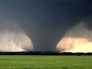
Developing LARGE tornado number 2 (the left edge of the tornado is just over the roadway. Very rapid rotation - Multi vortex tornado that hit Wichita on May 19, 2013. Note the satellite vortex just above the pole in the center of the photo. The view is WNW. |
|
One of many intense supercell storms near Northern Oklahoma on May 19, 2013. The view is South. Numerous tornadoes affected the northeastern portions of Oklahoma City this day. |
|
Monsters always start 'small' ... This is the initiation of the Duncan and eventually the Moore, OK storm on May 20, 2013. The view is to the West. |
|
Split between two anvils ... One was the Duncan, Oklahoma supercell and the other the devastating Moore, Oklahoma storm on May 20, 2013. |
|
This is the powerful updraft of the Moore, OK tornadic supercell storm about 10 minutes before it destroyed the town on May 20, 2013. The view is to the NE. |
|
Some tornadic activity on the SW side of the Duncan supercell (the cell SW of the Moore, OK storm) on May 20, 2013. The view is to the West. |
|
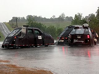
There is indeed now MORE than ONE 'Dominator' - May 20, 2013. Three of such vehicles operating for the Weather Channel to the nort of Duncan, Oklahoma. |
|
Gust front from tail-end storm 25 miles or so south of Waco, Texas on May 21, 2013. |

|
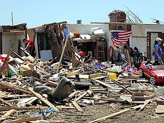
Moore, Oklahoma tornado from May 20, 2013 (picture taken on May 22) - Tornado survivor (lucky and thankful to be ALIVE) holding his cat in front of his destroyed home. |

|
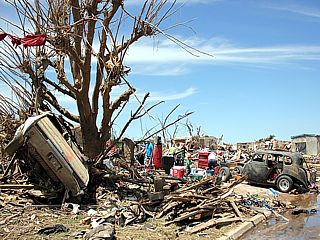
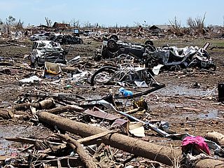
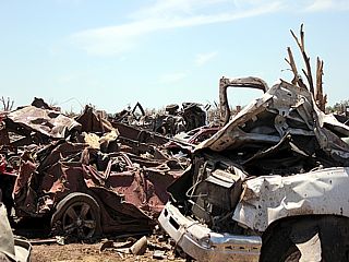
Moore, Oklahoma tornado from May 20, 2013 (picture taken on May 22) - Unrecognizable remains of homes / debris piled high by tornado. |
|
Moore, Oklahoma tornado from May 20, 2013 (picture taken on May 22) - Car in debarked tree and destroyed home. |
|
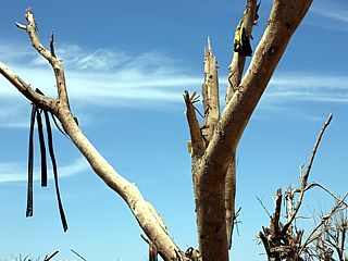
Moore, Oklahoma tornado from May 20, 2013 (picture taken on May 22) - Trees debarked. |
|
Moore, Oklahoma tornado from May 20, 2013 (picture taken on May 22) - Car buried in remnants of a home. |
|
Moore, Oklahoma tornado from May 20, 2013 (picture taken on May 22) - Sidewalk along path of destruction. |
|
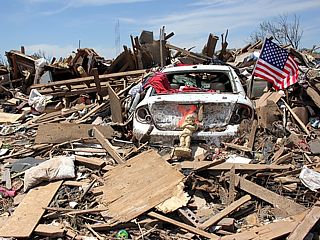
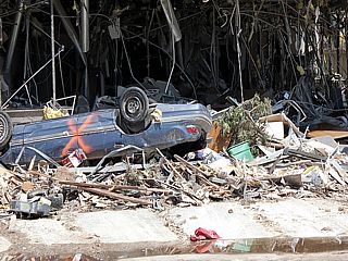
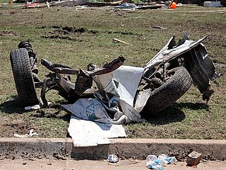
Moore, Oklahoma tornado from May 20, 2013 (picture taken on May 22) - Overturned vehicle in front of destroyed medical offices. |
|
Moore, Oklahoma tornado from May 20, 2013 (picture taken on May 22) - Debris strewn across landscape. |
|
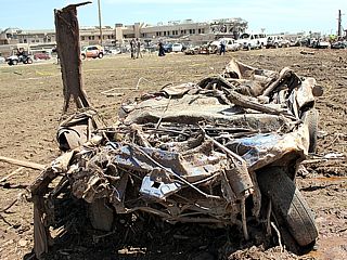
Moore, Oklahoma tornado from May 20, 2013 (picture taken on May 22) - Completely flattened pickup truck / SUV (?). |
|
Moore, Oklahoma tornado from May 20, 2013 (picture taken on May 22) - Destroyed vehicle remains / man walking through debris. |
|
Moore, Oklahoma tornado from May 20, 2013 (picture taken on May 22) - Vehicle remains (once inside garages of disintegrated homes) piled in a field. |
|
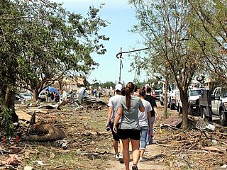
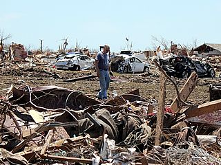
Moore, Oklahoma tornado from May 20, 2013 (picture taken on May 22) - Destroyed residence and people going through rubble. |
|
Moore, Oklahoma tornado from May 20, 2013 (picture taken on May 22) - Remains of axel from a vehicle. |
|
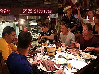
Some folks eating dinner at the Big Texan Steakhouse in Amarillo, Texas ... Eat this 72 Oz steak and all the sides in an hour or less ... Then it's free! |
|
First tornado (or maybe just dust updrafting)? To the west of Dougherty, Texas and to the south of Highway 62. There it is? - Peaking through the 60+ knots inflow dust! May 23, 2013. I was later told by chasers (George Kouranis and his group) that this was just rapidly rising dust. The view is Southwest. |
|
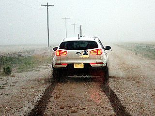
Muddy road and hail core in the storm west of Doughtery, Texas on May 23, 2013. Photo taken by Clarence Bennett. |
|
Possible tornado near Rotan, Texas during the evening of May 23, 2013. The view is to the NNW. |
|
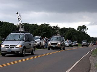
Just a part of the chaser convergence near Sheridan Lake, Colorado near an LP supercell (George Kourounis, Charles Edwards, and Daniel Shaw) on May 24, 2013. |
|
Hail falling near Cheyenne Wells, CO on May 24, 2013 under a developing LP supercell storm. |

|
Hail near Cheyenne Wells, CO on May 24, 2013 under a developing LP supercell storm. |
|
George Kouranis daying "When YOU tell me the LCL's gonna be low - You BETTER mean it!" ... No, we're just having fun under the meso south of Goodland, Kansas on May 24, 2013. |
|
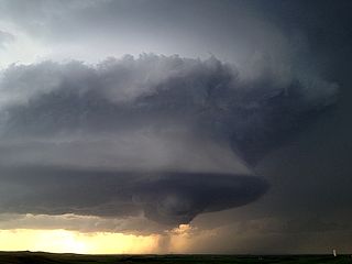
LP Supercell just before splitting and intensifying again to the NW of Goodland, Kansas on May 24, 2013. |
|
Myself smiling and the Rapid City, South Dakota supercell on May 25, 2013 just after arriving near the storm and driving to it from nearly 200 miles away! This long-lasting storm developed much earlier near Sturgis, South Dakota and slowly drifted to the ESE for nearly half the day in the afternoon. |
|
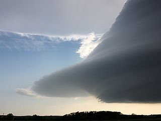
Storm structure with powerful RFD of the Rapid City, South Dakota supercell on May 25, 2013. The view is to the NNW. |
|
"Stacked-Plates" appearance of the SE side of the Rapid City, South Dakota supercell on May 25, 2013. The view is to the NNW. |
|
Impressive structure (with rotating wall cloud) of the Rapid City, South Dakota supercell on May 25, 2013. The view is to the NNW. |
|
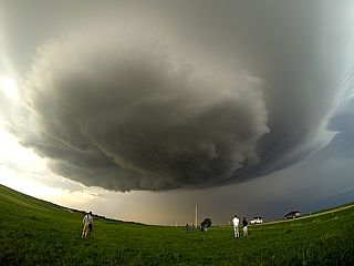
Wide angle shot of some chasers under the 'meso' of the Rapid City, South Dakota supercell on May 25, 2013. |

|
Weakening (downscale development) at dusk of the Rapid City, South Dakota LP (low precipitation) supercell on May 25, 2013. |
|
Developing LP supercell in Custer County, Nebraska on May 26, 2013. The view is to the SE. Massive upward motion on this storm. |
|
Incredible supercell structure with this LP supercell near Broken Bow, Nebraska on May 26, 2013. The view is to the West. |
|
"Mothership" appearance of LP supercell near Broken Bow, Nebraska on May 26, 2013. The view is to the South. |
|
Another view of the "Mothership" / "stacked plates" appearance of LP supercell near Broken Bow, Nebraska on May 26, 2013. The storm is to the NNW of me as it lumbers above the Plains of the Central USA. |
|
Incredible supercell structure realized in this wide-angle view from under the LP supercell north of Broken Bow, Nebraska on May 26, 2013. The centroid of rotation is just right of the center of the photo. |

|
Partially melted giant hail (originally from tennis to baseball sized) after the passage of the LP supercell in Custer County, Nebraska on May 26, 2013. |
|
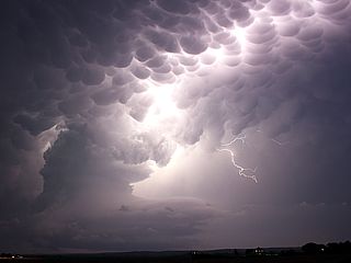
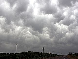
Lightning and mammatus from weakening LP supercell in Nebraska on May 26, 2013. |
|
Wider shot of lightning and mammatus from weakening LP supercell in Nebraska on May 26, 2013. |
|
Rotating wall cloud / updraft over Osborne, Kansas on May 27, 2013. The view is SSW and this supercell is one of a line of supercell storms along the dryline. This was also the last time I saw Tim Samaras and his group chasing storms and / or caravaning with them. |
|
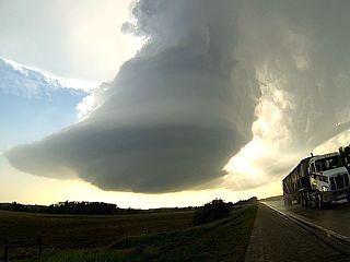
Tail-end supercell south of I-70 and west of Salina at dusk in Kansas on May 27, 2013. The view is ESE. Note the interesting 'barber pole' structure in the lower center (mesocyclone) and RFD cut just to its right. Lightning is ocurring to the left (in the hail shaft). |
|
First funnel and small tornado developing on May 28, 2013 near Minneapolis, Kansas. The view is to the WSW from an area with tennis ball sized hail falling. |
|
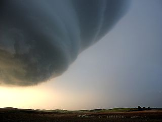
Developing large tornado west of Minneapolis, Kansas on May 28. This is near the end of I-135 north of Salina, Kansas. The view is WSW. |
|
Wide angle view of developing strong tornado on May 28, 2013 near Minneapolis / Bennington, Kansas. The view is to the WSW. |
|
View of intensifying and a soon-to-be violent tornado on May 28, 2013 near Minneapolis / Bennington, Kansas. This large tornado (3/4 mile wide in this picture) is intensifying and will pack winds of EF-4 strength. The view is West. |
|
Myself in the chase vehicle (my 'office' for two weeks) near Minneapolis / Bennington, Kansas on May 28, 2013 watching the wedge tornado becoming rain wrapped. This is on old highway 81 and I am facing West. |
|
Large (Wedge) tornado starting to become rain-wrapped while nearly stationary. Shot is looking west from near Minneapolis / Bennington, Kansas on May 28, 2013. This tornado was rated EF-4 and was on the ground for OVER an hour! |
|
Supercell structure of the HP storm (the wedge tornado is now completely rain-wrapped) as the DOW (Doppler on Wheels) scans the storm. May 28, 2013 near Minneapolis and Bennigton, Kansas. The view is to the SSW. |
|
Powerful gust front and outflow ahead of a bowing-segment in a line of severe thunderstorms near Briscoe, Texas on May 29, 2013. The view is to the NNW. |
|
Mammatus looming above western Oklahoma on May 29, 2013. This is on the backside of a powerful MCS. |
|
Developing supercell storms near Guthrie, Oklahoma on May 30, 2013. The view is south and southeast. |
|
Developing brief tornado viewed from near Coyle, OK on May 30, 2013. This tornado had a slight ground dust swirl, but quickly weakened after that. The view is WNW. |
|
Brief tornado (some chasers closer in confirmed ground circulation briefly) near Perkins, OK on May 30, 2013. This was a second brief tornado as the supercell cycled. The view is NNE. |
|
Chasers jamming the roads in Oklahoma near Agra, OK on May 30, 2013. |
|
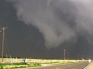
Wedge tornado approaching El Reno, Oklahoma on May 31, 2013. This view is looking WSW from a cemetary in El Reno and the tornado is a few miles away. |
|
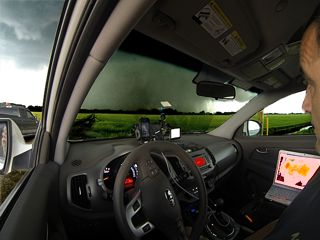
Developing wedge tornado and wall cloud (these features had violent motion) and my chase vehicle near El Reno, Oklahoma on May 31, 2013. I am heading south quickly on Highway 81. |
|
Wedge tornado with rain wrap (there is even a barely visible satellite tornado to it's right)! - Near El Reno, Oklahoma on May 31, 2013. |
|
Wedge tornado - Near El Reno, Oklahoma on May 31, 2013. This tornado is rapidly intensifying and part of as larger circulation that will eventually become a 2.6 mile wide EF-5 tornado with 296+ MPH winds. |
|
Yes - I'm scared - And close to being killed in this picture. I am trying to race southward on Highway 81 (south of El Reno, Oklahoma) to get out of the outer circulation of a rapidly intensifying EF-5 tornado that would quickly become 2.6 miles wide and pack winds near 300 miles per hour. I am in the 100+ Knots inflow and looking back, the massive tornado looms behind me in the extreme wide-angle shot. Holding the camera (GoPro 3) was almost impossible, and the raindrops caused abrasive-like scrapes and cuts on my wrist. Scientists Tim Samaras, Paul Samaras, and Carl Young were behind me somewhere and lost their lives in the tornado. This is May 31, 2013 and the view is looking N to NNW. |
|
Wedge tornado moving away and to the east of Highway 81 and southeast El Reno, Oklahoma on May 31, 2013. This is at the point where the EF-5 tornado grew from a mile wide to 2.6 miles wide in 30 seconds! Most likely, this WEDGE tornado might be a "sub" vortex rotating around the large circulation! The actual left "edge" of the 2.6 mile-wide tornado is far out-of-frame to the left and not visible in this picture. Windspeeds were near 296 MPH at this point! |
|
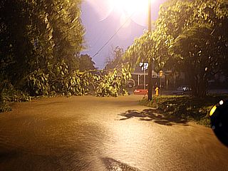
Quick shot of the flooding in suburban Oklahoma City late on the evening of May 31, 2013 ... Note the cars floating just upper-right of the center near the yellow hydrant. Trees are down and flash floods are ocurring, with rushing water in the streets! All this in addition to record-breaking tornadoes. |
|
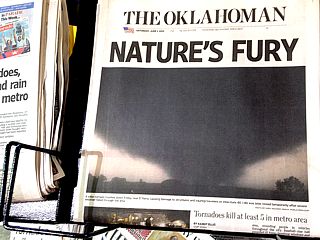
Upon leaving Oklahoma City and having breakfast on the morning of June 1, 2013 - The grim news appears in every news stand across Oklahoma. |
|
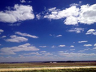
An otherwise beautiful fair-weather day unfolds after the previous meteorological "mayhem" over the past couple of weeks on June 1, 2013 while doing the long drive back to Denver, Colorado. In this picture, deep blue skies and fair weather cumulus prevail over Kansas and along Interstate 70. |
|
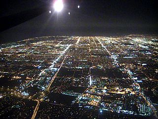
The last few moments of an epic (and sad) chase trip ... heading back into Fort Lauderdale, Florda late on June 2, 2013 and overflying the beautiful city lights (from Denver, Colorado). |
HTML File "mwcl2013.htm" - Developed By Chris Collura
To Return To The HOME Page Of This Site Click The "INDEX.HTM" Link Here!