
| This section is for storm chases done in the central / Midwestern United States during the year of 2010. This includes all storm chasing activities (including any major chase "expeditions") during the year of 2010 in the central USA (aka "Tornado Alley"). For 2010, all chases in the central USA will be logged in this section, with many of the chases being possible "spot" chases / major severe weather "setups" chased. Here you should find many pictures of lightning, possible tornadoes, along with many severe thunderstorm elements. Keep in mind that this chase log is scientific evidence and portrays my on-going storm chasing research. It has been placed on this page for easy reference and meteorological interests. Please do not plagiarize or copy this document to other sites for distribution. Note - This page may take a while to load on some SLOWER connections! |
STORM CHASING - CENTRAL UNITED STATES - 2010 CHASE LOGS
| CHASER NAME | HOME CITY | CALLSIGN | CHASE DATES | OCCUPATION |
| CHRIS COLLURA | SUNRISE, FL | KG4PJN | 4-21 TO 4-25 | IT CONSULTANT |
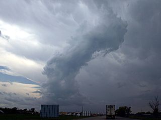
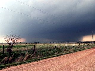
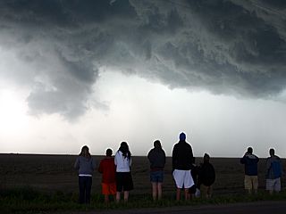
1). April 22, 3:30 PM - Interception and observation of an extremely severe thunderstorm between Guymon, Oklahoma and Liberal, Kanasas from along Highway 54 (Near Hooker / Tyrone) mainly in Texas County, Oklahoma and Seward County, Kansas. The storm was a classic supercell thunderstorm, and produced at least one weak tornado during its observed life-cycle of a couple of hours. A possible view of the brief tornado was made from a distance of about 5 miles. The storm core was not penetrated, but winds (inflow) of about 35 MPH were experienced, along with frequent lightning. The storm core also had hail at least golfball sized. Conditions causing the storm were a dryline / frontal boundary interaction (triple point), surface heating, a low pressure area, and strong winds (divergence) aloft / wind shear. A 2009 Kia Forte was used to chase the storms. Documentation was still digital photos and HD video. A tornado watch was also in effect for the area until 10 PM CDT.
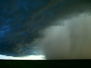
2). April 22, 6:30 PM - Interception and observation of an extremely severe thunderstorm near Perryton, Texas in Ochiltree County from along Highway 83. The storm was a classic supercell thunderstorm with a possible tornado (not directly observed). The main core of the storm (also with 60 MPH+ winds and frequent lightning) was not penetrated, however, a region of large hail (1") covering the ground was encountered with inflow winds to near 50 MPH roughly 5 miles from the storm core (hail was falling from storm anvil). Conditions causing the storm were a dryline / frontal boundary interaction (triple point), surface heating, a low pressure area, and strong winds (divergence) aloft / wind shear. A 2009 Kia Forte was used to chase the storms. Documentation was still digital photos and HD video. A tornado watch was also in effect for the area until 10 PM CDT.
3). April 23, 4:00 PM - Observation of an very severe thunderstorm near Perryville, Arkansas in Perry County near Highways 9 and 10. The storm was a multicell storm cluster with an embedded and intense HP supercell. The storm was also tornado warned (radar indicated). The of this storm was not penetrated, but the chase path came across hail fig and a hail accumulation on the ground behind the storm near Harris Brake reservoir. The storm core contained winds to about 60 MPH and hail up to 1". The storm was followed to near I-40 and the town of Morrilton (where tornado sirens were activated). Conditions causing the storm were surface heating, a low strong pressure area, and strong winds / cold air aloft. A 2009 Kia Forte was used to chase the storms. Documentation was still digital photos and HD video. A tornado watch was also in effect for the area until 8 PM CDT.
4). April 23, 6:00 PM - Observation and penetration of a strong to severe thunderstorm near Lonoke, Arkansas in Lonoke County along and near Highway 70. The storm was a multicell storm and contained winds near 60 MPH, small hail, torrential rains, and frequent lightning. Conditions causing the storm were surface heating, a low strong pressure area, and strong winds / cold air aloft. A 2009 Kia Forte was used to chase the storms. Documentation was still digital photos. A tornado watch was also in effect for the area until 8 PM CDT.
5). April 23, 9:00 PM - Observation and penetration of a very severe thunderstorm near Prescott, Arkansas in Nevada County along and near Interstate 30 and southward along Highway 371 (eventually to near Stamps). The storm was a supercell storm (possibly tornadic) and contained winds over 70 MPH, large hail to about 1", torrential rains, and frequent lightning with some close hits. The tornado (if any) was not observed once in the rain-free region of the storm. Conditions causing the storm were surface heating, a low strong pressure area, and strong winds / cold air aloft. A 2009 Kia Forte was used to chase the storms. Documentation was still digital photos and HD video. A tornado watch was also in effect for the area until 3 AM CDT the next day.
6). April 24, 4:30 AM - Observation of a very severe thunderstorm at a motel off exit 223 of Interstate 30 in Texarcana, Arkansas in miller County. The storm was an intense multicell storm that pushed through the area, and the observation was made right at where I was staying for the night. Winds over 60 MPH, hail up to 1", some covering the ground and entering the room of the motel when the door was opened, torrential rains, and very frequent lightning with close hits. Conditions causing the storm were surface convergence, an approaching area of strong low pressure, and strong winds / cold air aloft in a highly sheared environment. A 2009 Kia Forte was used to chase the storms. Documentation was HD video. A tornado watch was also in effect for the area until 8 AM CDT.
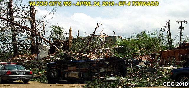
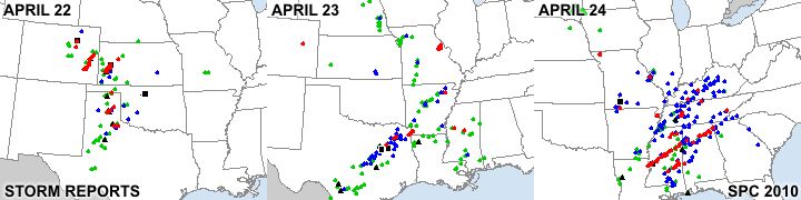
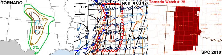
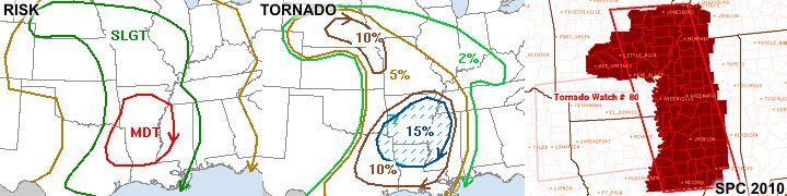
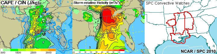
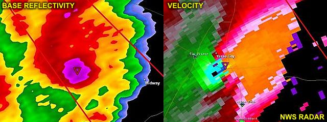
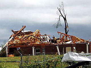
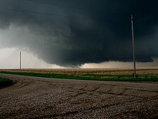
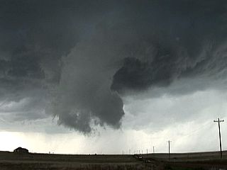
7). April 24, 11:30 AM - Observation and indirect penetration of an extremely severe and violent tornadic thunderstorm from northwest of, and to near Yazoo City, Mississippi in Yazoo County from highways 49 and 61 with the chase coming to and end near Highways 49 and 16. This storm was a violent, and long-track HP supercells storm, that originated in northeastern Louisiana, crossed the ENTIRE state of Mississippi, then weakened in western Alabama. The storm was also a very fast-moving storm, so getting in front of the storm was difficult. The storm core had large hail and very strong winds. The most tragic aspect of this supercell was the large long-track tornado it produced, with a 100-mile long path, and a width of 1.75 miles! A brief view of this tornado, although rain-wrapped, was encountered in the storm core, about 3-5 miles northwest of Yazoo City. Tress / other small debris was also noted falling OUT of the sky in this area. A path was chosen to divert to the northeast and around the storm because of the danger, coming back around to 49 and heading south into Yazoo City. Winds at least 70-75 MPH were encountered in this area, from the east and southeast. The damage path was encountered behind the storm, still in strong winds and rain, and much of the area south of town, near Highway 49 and 16, had catastrophic EF-4 tornado damage. The chase had to be aborted to help with clearing roads / assisting emergency personnel in Yazoo City. The storm containued to the NE out of sight thereafter, as I was helping with the victims of the storm. Unfortunately, 4 people were killed in Yazoo city, so this is NOT a happy chase log. Conditions causing the storm were surface convergence, an approaching area of strong low pressure, and strong winds / cold air aloft in a highly sheared environment (divergence aloft and strong veering of winds with height). Helicity in this area was also a staggering 1000 with CAPE near 3,000 (and EHI of near 19)! A 2009 Kia Forte was used to chase the storms. Documentation was digital stills HD video of the damage / emergency efforts. A PDS tornado watch was also in effect for the area until 1 PM CDT (and extended to 8 PM CDT).
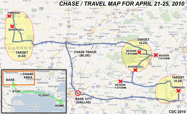
This concludes the Chase Log for the US Great Plains, Midwest, and deep south tornado chase trip from April 21 through April 25, 2010. This chase summary includes a total of 7 strong / severe thunderstorms, out of which, 2 tornadoes were observed. One of the tornadoes was a violent long-track (EF-4) tornado that struck Yazoo City, Mississippi on April 24 with devastating, and fatal results. The main chase vehicle conducting all chases was a 2009 Kia Forte. This information was prepared exclusively for the National Weather service and the team of Skywarn storm spotters.
|
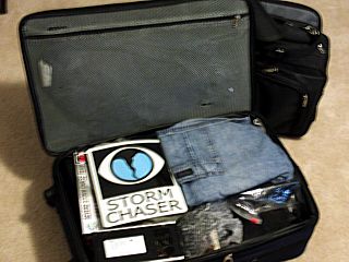
Here is all my chase gear, clothes, and electronics packed tightly into a mere two carry-on bags for the 5 day chase trip. Packing light and in a carry on saved time and threat of equipment damage. I always love the expressions on the TSA people at the airport when the bags go through the X-Ray machine! |
|
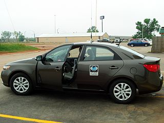
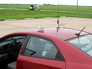
Here is a picture of the chase rental vehicle, a 2009 Kia Forte, ready to go with equipment mounted and running. The electronics are all powered by a long cable that clips to the battery terminal, protected by its own fuses, and runs to the invertor, laptop, radio, and such in a simple and quick setup. |
|
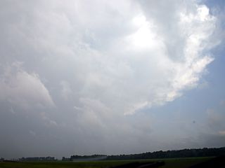
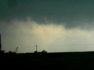
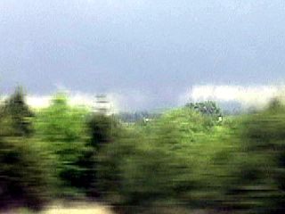
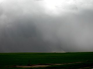
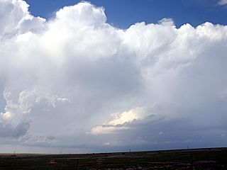
Here is a picture of the first developing supercell storm southwest of Liberal, Kansas (near and northeast of Guymon, Oklahoma at the time (view is southwest). Note the "turkey tower" of cumulus in the foreground billowing upwards, then getting toppled over by the directional (and bulk) shear. |
|
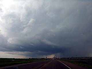
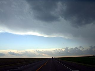
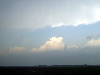
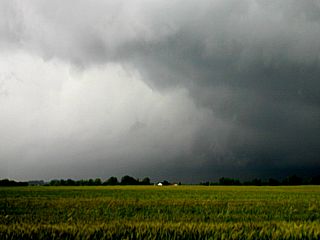
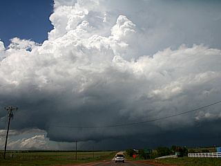
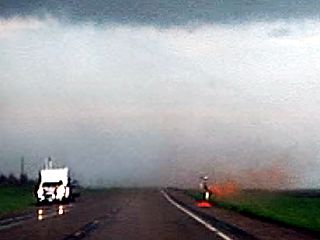
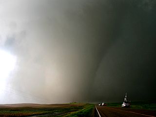
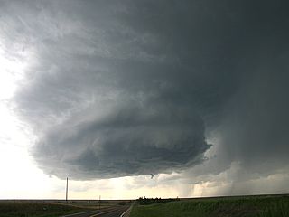
Approaching the supercell storm near Hooker, Oklahoma. Nice rain-free base becomes evident. |
|
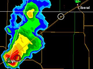
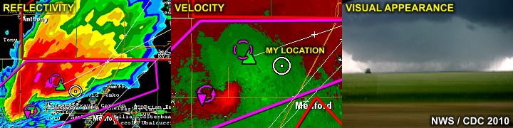
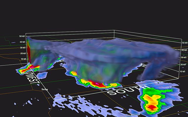
Here is a radar image (base reflectivity) of the supercell storm as it was southwest of Hooker, Oklahoma. The view is to the southwest. |
|
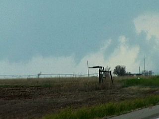
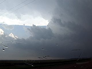
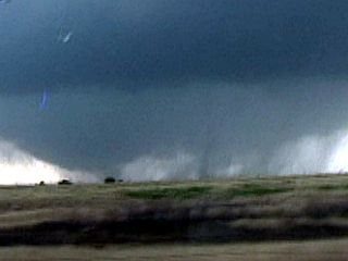
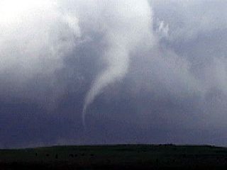
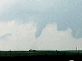
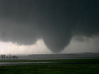
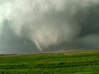
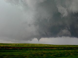
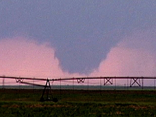
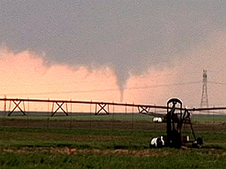
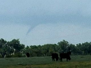
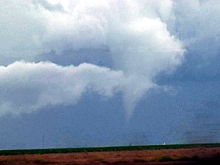
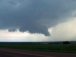
Looking closely at the wall cloud and updraft region of the supercell, a funnel / possible weak tornado is visible (center). The view is also to the southwest. |
|
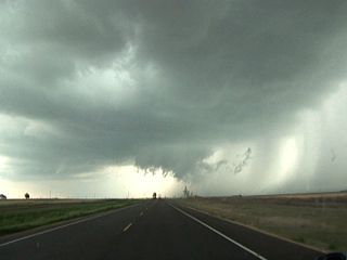
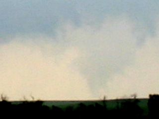
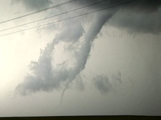
Here is another funnel that developed as the storm drew a bit closer, with a rotating wall cloud (center). The view is to the west. |
|
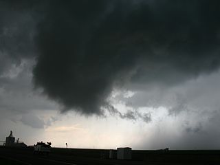
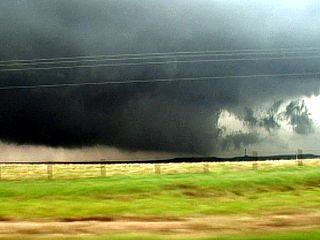
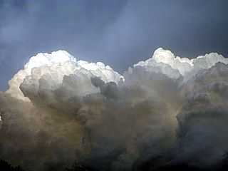
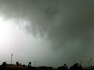
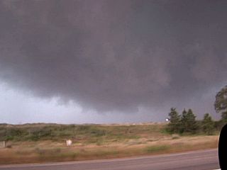
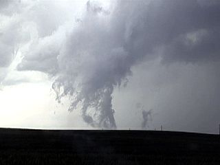
Here is another picture of the rapidly rotating wall cloud / funnel just before the storm became occluded and weakened. This was near Hooker, oklahoma along Highway 54. The view is to the northwest. |
|
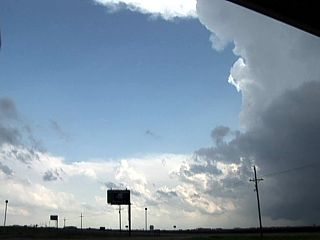
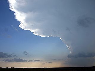
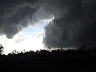
This is a picture of the anvil blowoff at high altitudes near Perryton, Texas just east of another supercell storm. The view is to the south, and the interesting thing is the upper-level divergence (difluence) can be seen as the anvils (one from the supercell out of frame to the right, and from the storms farther away) get farther apart as one proceeds eastwards (to the left in this picture). |
|
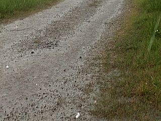
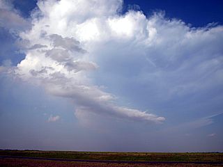
This picture appears to be far away from the Paerryton, Texas supercell storm to be concerned (it's updraft is far to the right to the southwest in this picture). However, hail up to 1" is falling from the anvil of the storm and into the "clear blue" air, and actually covered the ground at one point! |
|
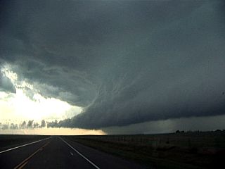
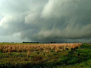
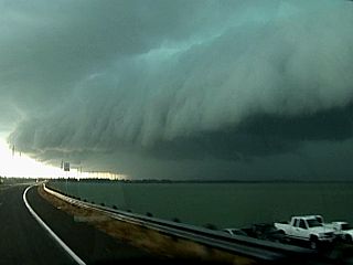
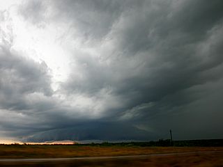
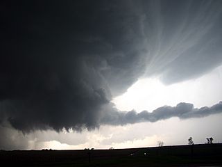
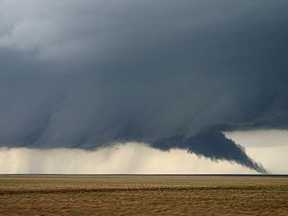
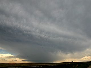
Interesting shelf cloud associated with a multicell / HP storm north of Pampa, Texas while headed south along Highway 70. The view is to the south, and the inflow can easily be seen going from left to right. |
|
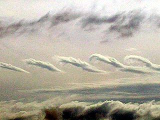
These interesting wave / rotor clouds (looks like mid-level HCR's) were encountered in the mid-levels over eastern oklahoma / western Arkansas. Most likely this is a result of directional shear in the atmosphere. |
|
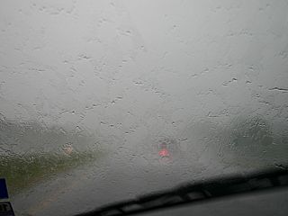
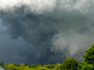
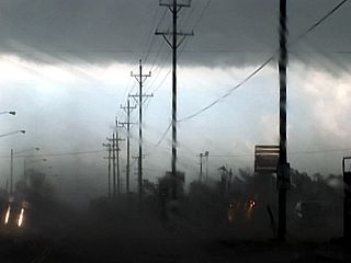
This is the visibility out the front windshield during one of the severe storm penetrations near Lonoke, Arksansas. |
|
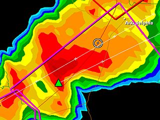
This is a base reflectivity radar of the supercell storm not far from Prescott, Arkansas. Notice the white circle of my GPS position (heading was SW along I-30 and into the core and rain-free area) - Yikes! |
|
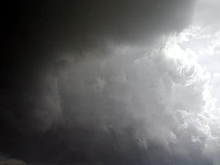
A poor-visibility view from inside the supercell core near Prescott while it was producing 70 MPH+ winds and hail up to 1". |
|
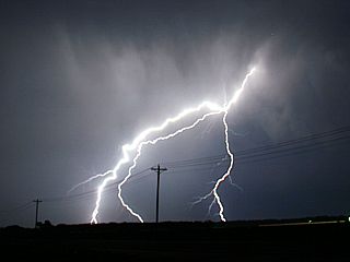
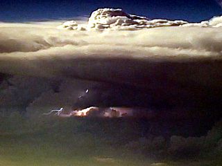
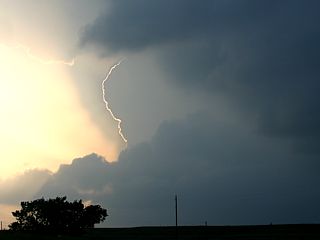
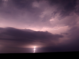
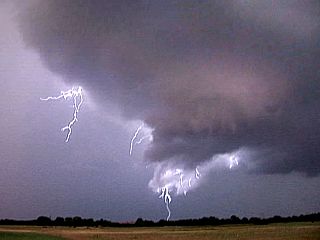
Cloud to earth lightning strike on the backside of the thunderstorm complex from near Beck, Arkansas. |
|
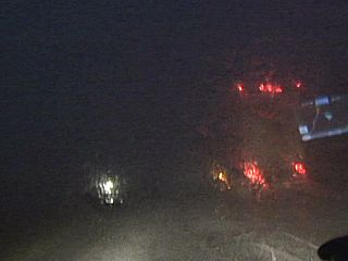
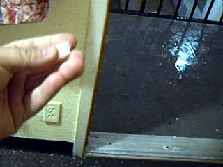
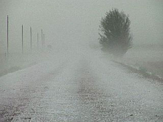
Here is a picture of the door of my motel room and hail coming into the door in Texarkana, Arkansas in the early morning hours of April 24. This night-time severe storm was the very start of a tragic day of severe weather. |
|
Here is a view of the back-sheared anvil of the violent HP supercell storm about 30 minutes before it struck the town of Yazoo City, Mississippi. The view is to the south, and taken from near Hollandale. |
|
This is another view, looking to the southwest, when closer to the soon-to-be Yazoo City supercell. The dry-punch of air creates a clear slot that pushes into the unstable air in a highly sheared environment (not the blow-off in the top of the picture, and cumulus line). |
|
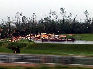
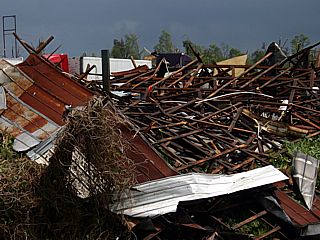
Destroyed church in Yazoo City, Mississippi near the junction of Highway 49 and 16. |
|
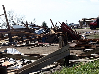
Major structural damage in Yazoo City, Mississippi just west of Highway 49. |
|
High end EF-3 to EF-4 damage in Yazoo City, Mississippi. |
|
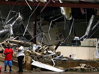
Dazed - But otherwise OK - Yazoo City locals stand outside a building that was nearly completely destroyed by the tornado. |
|
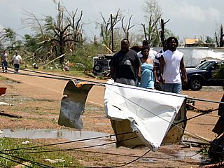
Locals wandering unscathed out of the hardest hit area of Yazoo city, along Old Benton Road. These people were very lucky, most likely because timely warnings were given for the storm, and they sought shelter in their basement / closet. Note the live downed powerlines in the foreground. |
|
Freshly destroyed home on the south side of Old Benton Road, Note the ruptured water pipe creating a fountain. |
|
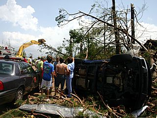
Some Yazoo City locals, also lucky to be uninjured, standing aside an overturned (and mangled) pickup truck, as the first heavy equipment clears the way for emergency crews to enter the hard-hit areas off Old Benton Road. |
|
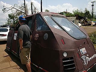
The TVN (Tornado Videos) group of storm chasers was also on this storm, and also stopped to assist. Storm chasers do not like to meet one another in such dire places. It's a sad thing. The "Domonator" vehicle, very similar to the TIV, is also designed to penetrate tornadoes, but not ones as stong as this. |
|
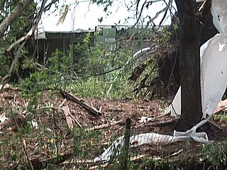
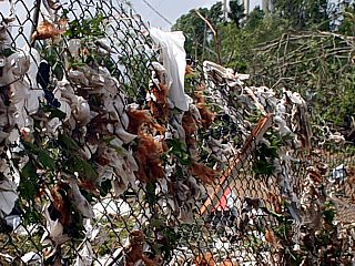
This is a chain-link fence after the tornado. The air flowing through this fence was filled with debris and "projectiles", which became trapped in the fence ... Try to imagine what would happen to anyone standing in this place during the tornado. |
|
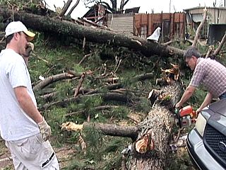
My part of the stop-and-help work was to help with clearing the roads of tree and other debris. Here a few locals were cutting up the fallen trees so they can be moved by a group of men. Each cut log section weighed hundreds of pounds ... But the tornado moved these as they were whole trees (along with vehicles, roofs, etc) as if they were blowing dust. |
|
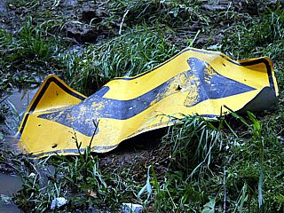
this road sign, all twisted and mangled, was no match for the 170 MPH+ core winds of the Yazoo City tornado. This was also one of many "objects" that moved around the tornado's debris field at aircraft speeds during the storm. |
|
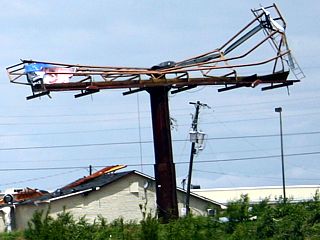
Destroyed bill board sign on the south side of Yazoo City near Highway 16 and along Highway 49. |
|
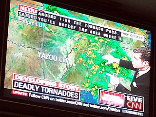
The painful reminder of the Yazoo City tornado disaster is mirrored on CN on one of the televisions at the Dallas Airport as I wait for my flight back to Florida. Going home with this in the back of my mind (having experienced the event first hand) is quite humbling. |
|
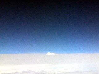
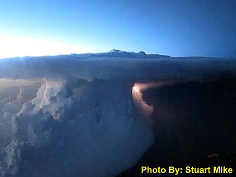
The distinct signature of a thunderstorm updraft peeks above the turbulent high-altitude cirrus deck while flying over the northern Gulf coast and encountering the line of severe thunderstorms (near eastern Alabama at this point) on April 25. The white "dome" (lower-center) is the top of a thunderstorm updraft, probably 50 to 100 miles away. We were flying at about 38,000 feet. |
| CHASER NAME | HOME CITY | CALLSIGN | CHASE DATES | OCCUPATION |
| CHRIS COLLURA | SUNRISE, FL | KG4PJN | 5-8 TO 5-13 | IT CONSULTANT |
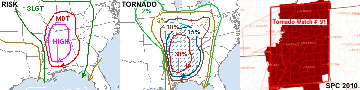
1). May 10, 4:30 PM - Observation of an extremely severe and violent tornadic thunderstorm in Grant County, Oklahoma from near Highway 81 and the town of Renfrow. The storm was a classic supercell thunderstorm that evolved to a violent HP storm that produced at least two tornadoes, both multi-vortex in nature, and one a wedge tornado west of Renfrow, Oklahoma. Both tornadoes were observed, one (near Wakita, Oklahoma) from a distance, and the multi-vortex / wedge from a few miles directly in its path. Large hail was also observed falling from the anvil of the storm, up to 1", with 50-60 MPH inflow winds. The main core of the storm was not penetrated. Light rain and frequent lightning was also noted with the supercell. Damage was anywhere from downed trees to major damage to homes in the tornados path, particularly near the town of Renfrow. The storms were caused by an intense (Colorado) low-pressure system, upper-level low, dryline and warm-front (triple-point) interactions, and surface heating. Documentation was digital stills and HD video. A 2009 Kia Forte was used to chase the storm. A PDS tornado watch was also valid for the area until 10 PM CDT.
2). May 10, 6:30 PM - Observation of an extremely severe and tornadic thunderstorm in Osage County, Oklahoma from near Highway 60 and from Ponca City to near Pawhuska. The storm was a large classic supercell thunderstorm with multiple areas of rotation. An indirect penetration was executed across the storm core and rain hook, and into the rain-free (mesocyclone) of the storm. Hail up to 2" was observed, with very heavy rains, lightning, and 60-70 MPH wind gusts. A possible tornado, although rain wrapped but weak, was encountered west of Burbank, Oklahoma. Leaves / tree debris was also noted falling from the sky. Farther east, two tornadoes were observed, one at a distance, to the east near Pawhuska, and another closer to the north of Highway 60 near Shidler. Tree damage and downed powerlines were encountered with this storm. The storms were caused by a strong low-pressure system, upper-level low, approaching dryline, and surface heating. Documentation was digital stills and HD video. A 2009 Kia Forte was used to chase the storm. A PDS tornado watch was also valid for the area until 10 PM CDT.
3). May 10, 7:30 PM - Observation and penetration of a very severe thunderstorm in Chautauqua County, Kansas from near Highway 99 and Highway 166 near the town of Sedan and eastward to southeast of Havana. The storm was a supercell storm, possibly formerly tornadic, evolving to an intense line segment as the dryline boundary surged in from the west. The storm had winds gusting near 60-65 MPH, torrential rains, lightning, and small hail. The storms were caused by a strong low-pressure system, upper-level low, dryline, and surface heating. Documentation was digital stills. A 2009 Kia Forte was used to chase the storm. A PDS tornado watch was also valid for the area until 10 PM CDT.
4). May 11, 5:30 PM - Observation of a short-lived but severe thunderstorm southwest of Cordell, Oklahoma along Highway 55 and towards Carter in Beckham county. The storm was an LP supercell developing ahead of a dryline bulge. During its high point, it probably had dime-sized hail and strong inflow winds (over 35 MPH). The core of the storm was not penetrated. The strong capping inversion, and lack of substantial forcing to over come it, caused the storm to quickly dissipate, leaving only an orphan anvil behind. The storm was caused by a dryline, upper trough, surface trough, and surface heating. Documentation was digital stills and HD video. A 2009 Kia Forte was used to chase the storm. A tornado watch was also valid for the area until 10 PM CDT.
5). May 11, 8:30 PM - Observation of an extremely severe and tornadic thunderstorm west of Vici, Oklahoma along Highway 60 in Ellis and Woodward counties. The storm was a supercell thunderstorm, starting out as classic (or even HP), and weakening to LP before dissipation. The core of the storm contained hail to 2", but was not penetrated. A tornado was observed in the rain-free area as well as a large RFD clear slot northwest of Harmon. Frequent lightning and 40+ MPH inflow winds were encountered as well. The storm had a very striking visual appearance (BWER "vault" and "barber pole" updraft striations) during its LP phase near dusk. The storm was explosively developing on the intersection of the dryline and warm-front boundaries, and was supported by strong winds aloft, an upper trough, a low pressure trough, and surface heating. Documentation was digital stills and HD video. A 2009 Kia Forte was used to chase the storm. A tornado watch was also valid for the area until 10 PM CDT.
6). May 12, 4:30 PM - Observation of a very severe and possibly tornadic thunderstorm near Kingman, Kansas in Kingman County near Highways 400 / 54 and east of Highway 14. The storm was an HP supercell storm, developing in a broken line / cluster of severe storms. The core of the storm, containing hail up to 3" was not penetrated, but hail ahead of the storm to golf-ball size was observed. Heavy rains, 60 MPH winds, and frequent lightning were encountered. A large wall cloud was observed near Kingman before the storm became outflow dominant. The storm was caused by a low pressure system / trough, upper trough, surface heating, and a frontal boundary / gravity-wave interaction. Documentation was still photos and HD video. The chase vehicle was a 2009 Kia Forte. A tornado watch was in effect for the area until 10 PM CDT.
7). May 12, 6:00 PM - Observation and penetration of another very severe thunderstorm near Spivey, Kansas in Kingman County near Highways 42 and 14. The storm was an HP supercell storm, embedded in a broken line / cluster of severe storms. The storm was indirectly penetrated, and a wall cloud / large rain-free base was observed. The storm quickly became outflow dominant, and produced winds to 70 MPH (blowing dust / gustnadoes were observed ahead of the storm gust front). Small hail, torrential rains, and frequent lightning with some close hits were also observed. The storm was caused by a low pressure system / trough, upper trough, surface heating, and a frontal boundary. Documentation was still photos and HD video. The chase vehicle was a 2009 Kia Forte. A tornado watch was in effect for the area until 10 PM CDT.
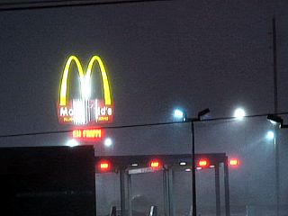
8). May 12, 11:30 PM - Observation of a very severe thunderstorm from a hotel along Interstate 29 and just east / south of Interstate 435 in the northern sections of Kansas City, Missouri in Platte County. This severe storm was observed from a motel while wrapping up the chase trip, and was an intense blow / squall line segment. Winds over 70 MPH with sideways torrential rains, small hail, and frequent lightning with some close hits were observed. A Mc Donalds sign was damaged across the parking lot during the storm. The storm was caused by a cold front and attendant low-pressure system, upper level low, and warm air advection (low-level jet aloft). Documentation was HD video. A 2009 Kia Forte was used in this storm chase. A tornado watch was also valid for the area until 12 AM CDT.
This concludes the Chase Log for the US Great Plains and Midwest storm chasing trip from May 8 through May 13, 2010. This chase summary includes a total of 8 interceptions with 8 severe thunderstorms observed. As many as 7 tornadoes (5 confirmed) were observed, two of which were very destructive. The main chase vehicle conducting all chases was a 2009 Kia Forte. is TBD. This information was prepared exclusively for the National Weather service and the team of Skywarn storm spotters.
|
Here is a picture of an intense multicell cluster of strong and severe storms north of the Florida / Alabama coast while flying from Orlando, Florida to Kansas City, Missouri. The airliner is circumnavigating the severe storms at an altitude of 34,000 feet, providing this great view of the storms (and lightning visible in broad daylight) from the right side of the aircraft (view is to the north). |
|
Here is the SAME chase vehicle (a red Kia Forte) I used on my previous chase trip - Same color too - Ready to start chasing and equipment installed. |
|
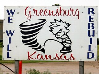
Interesting sign on the eastern part of Greensburg, Kansas. This was a town that was devastated in early May of 2007 from an EF-5 tornado. The entire town was rebuilt with energy efficiency in mind ... And a sense of humor too! |
|
Although not a very active chase day, with gloomy and grungy weather most of the day, some fast moving elevated storms managed to show up on radar by early evening on May 9 in extreme north-central Oklahoma near I-35. |
|
Here is a picture of the first major supercell storm during its very early stages of initiation. This storm was southwest of Vance, Air Force Base in northern Oklahoma. Beleive it or not, this small and innocent looking storm will eventually grow to a violent supercell and produce multiple tornadoes, including a multi-vortex / wedge tornado later on near the town of Rentrow. |
|
This is the same supercell storm's updraft and anvil blow-off as it approached Wakita, Oklahoma and just when it started producing tornadoes. The view is to the southwest and I am about 10 miles WSW of Rentrow. |
|
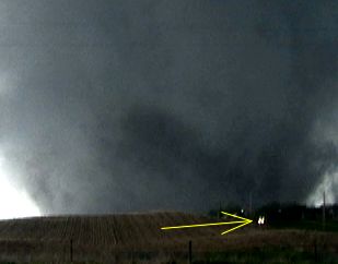
The supercell storm intensifies explosively and this dusty and wide wedge tornado develops to the southwest of Rentrow, Oklahoma. Getting this shot was literally a few minutes before the tornado, moving to the ENE at 60-MPH, would have reached my position. |
|
Here is a view of the multi-vortex / wedge tornado just before it beared down on Rentrow, Oklahoma. At least two sub-vortices (smaller tornadoes) can be seen "dancing" within the main tornado circulation. |

|
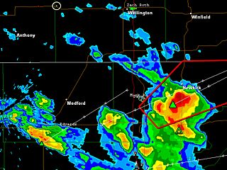
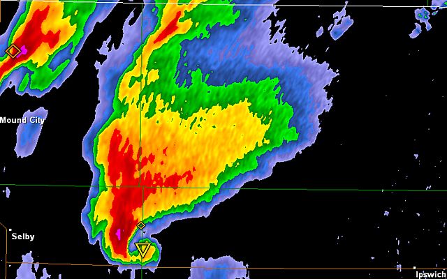
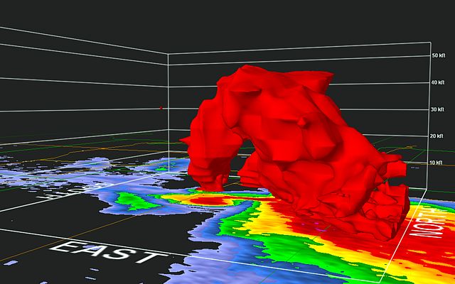
Doppler radar reflectivity image from Vance Air Force Base of the Wakita / Medford supercell during maximum intensity. This is got to be one of the most impressive radar images of a violent supercell I have ever seen. Note the "eye" like feature in the hook "knob" to the lower-left of the supercell! |
|
Another violent supercell produces hail over 2 inches in diameter east of Ponca City, Oklahoma along highway 60. This storm also produced tornadoes, one near Pawhuska and another south of Shidler. |
|
First view of a tornado on the ground near Pawhuska, Oklahoma off in the distance (image is enhanced, and the tornado silhouette is in the center of the image) from the supercell storm east of Ponca City. The view is to the east. |
|
Another tornado from the supercell storm east of Ponca City and south of Shidler, Oklahoma. The view is to the north, and this tornado is NOT the one near Pawhuska above (this supercell had multiple mesocyclones / tornadoes). |
|
Another view of the tornado in its later stages and becoming slightly rain-wrapped south of Shidler, Oklahoma. |
|
Large wall cloud associated with the older mesocyclone to the west of Shidler, Oklahoma just as the tornado south of that area formed from the new meso. |
|
Beautiful line of heavy cumulus, illuminated by the setting hazy sun to the west, associated with the passage of the potent dryline looking east north of Tulsa, Oklahoma. |
|
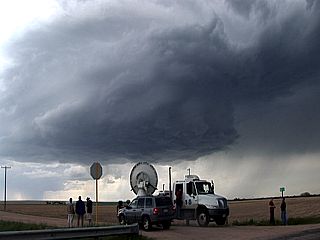
Here are two of the University of Massachusetts DOW (doppler on wheels vehicles) headed down Highway 183 to an initiating LP supercell southwest of Cordell, Oklahoma. |
|
This is a picture of an LP supercell storm that has initiated along a bulge in the dryline southwest of Cordell, Oklahoma. The small single updraft has an impressive anvil "crown" spreading overhead. The supercell updraft region is to the lower right. The view is to the west. |
|
About an hour later, the LP supercell southwest of Cordell, Oklahoma basically evaporated into nothing. Convective inhibition / lack of forcing was the culprit leading to the demise of the LP storm. The view is northeast. |
|
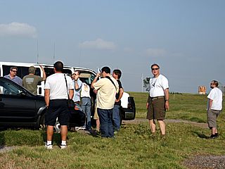
One of the storm chasing tour groups, with storm chaser Brian Morganti, second from right, scratching his head and deciding to go north after the LP storm southwest of Cordell "vanished". |
|
Farther north into nortwestern / west-central Oklahoma, a triple point (warm front and dryline intersection) causes initiation of more storms in a focused region. Once developing supercell breaches the "cap" and explosively develops west of Leedey, Oklahoma. The view is to the west. |
|
Here is a view of the same supercell undergoing explosive intensification near the dryline / triple-point. The view is to the west and northwest, and was taken a mere 15 minutes after the previous photo above. |

|
The supercell storm moves northeast away from west of Leedey and northwest of Vici. This brief tornado was caught from along Highway 60 between Vici and Harmon, Oklahoma. The storm weakend to LP and dissipated about an hour later. |
|
Here is the same supercell, still "anchored" on the triple-point, weakening to LP (low precipitation) with a spectacular "barber pole" updraft column at dusk about 10 miles south of Woodward, Oklahoma. |
|
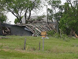
Damage to a farm stead near Wakita, Oklahoma. This damage was done by the edges of the circulation of the large tornado that went through the area on May 10. |
|
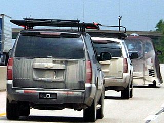
Here are some of the TVN (TornadoVideos.Net) group headed north on I-35 into Wichita, Kansas. The "Dominator" vehicle, with Reed Timmer, is in the lead. |
|
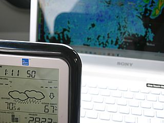
Here is a picture of my dewpoint / temperature sensor console, showing a dewpoint of at least 70 degrees F (lower left). Such high dewpoints indicate that moisture from the Caribbean / Gulf of Mexico has advected into the central US. |
|
Severe storms, with embeeded HP supercells, explosively develop along a slow-moving cold front west of Wichita, Kansas. The anvil / mammatus can be seen overhead with agitated cumulus in the lower levels. |
|
This is the inflow notch into an HP supercell storm, developing in the severe storm cluster, near Kingman, Kansas. A possible funnel is in the center of the picture. |
|
The same storm, now northeast of Kingman, Kansas, during evolution to an outflow dominant MCS. The mescocyclone is still present in the dark area in the center of the picture, but cold outflow is undercutting it, precluding the development of any tornadoes. |
|
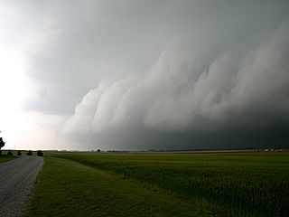
The gust front and shelf cloud of the now outflow-dominant storm northeast of Kingman, Kansas. |
|
The storms become outflow dominant, creating a large gust front and a microburst can be seen here kicking up a dust plume. This is near Kingman and west of Wichita, Kansas. |
|
This feature, looking east towards Wichita from near Kingman, shows a possible gustnado (swirling dust picked up by a strong gust front). |
|
Interesting RFD cleat slot on the "rotating head" cell on the north side of the outflow-dominant bow segment. The view is to the north. |
|
A severe thunderstorm, associated with a bow-segment of severe thunderstorms, blasts through the area north of Kansas City near the airport (near my motel) during the late night of May 12. Some signs, including the Mc Donalds sign here, were damaged by the storm, with winds exceeding 70-MPH. |

|
First light the next morning on May 13, after severe storms rolled through late at night, north of Kansas City and a damaged Mc Donalds sign. |
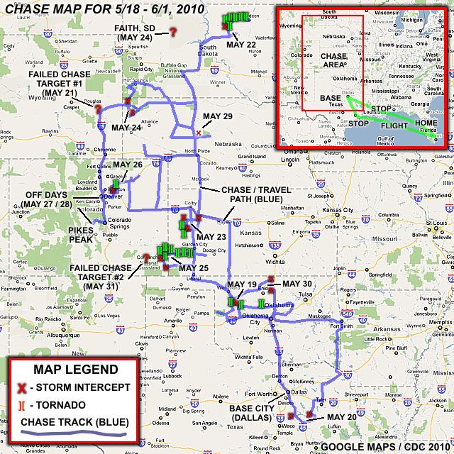
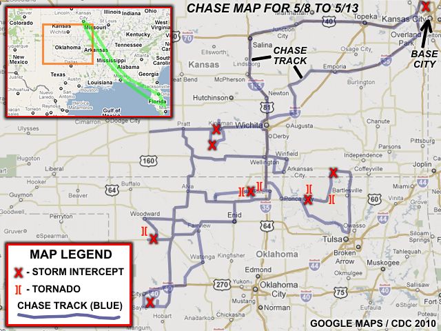
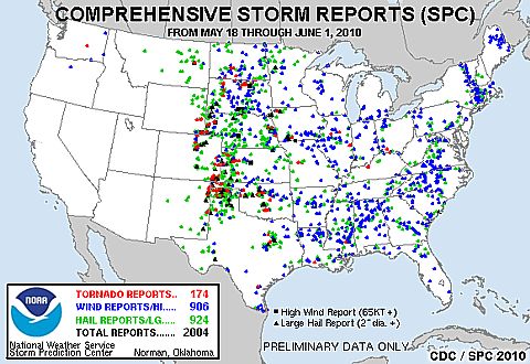
Above is a chase map for the entire chase trip from May 18, 2010 through June 1. The upper-right inset shows the chase area involved in the central USA and the flight to and from Fort Lauderdale, Florida to the "base" city of Dallas, Texas (with a stop in New Orleans, LA going out and Houston, TX returning). The symbol legend is in the lower-left, and any red "X" denotes a severe storm observation, while the green tornado symbols "][" represent a tornado / significant funnel observation. Any red "?" denotes a failed target chase (where the preferred storm-of-the-day / target area was not reached due to time / distance constraints and / or forecasting errors). There was a total of 15 travel days, of which, 13 of these days were available for chasing (day 1 and Day 15 were travel days). In these days, there were 9 chase days, 2 travel / down days, and 2 "bust" days (where a target could not be reached in time for storm interception). The two "bust" (failed-chase) days were May 21 and May 31. The storm intercept team involved for this trip consisted only of myself and was be "based" out of Dallas, Texas where I flew out to on May 18, 2010 and chase until June 1, 2010. The total mileage for this trip was 10,424 miles, as the above map does NOT show re-traced paths and / or country roads (AKA: "Bob's" / dirt roads). To put this distance into perspective, this is more than "driving" from Los Angeles to Tokyo, Japan then to Sidney, Australia (if there was a bridge across thre Pacific)! Such a staggering distance put on a rental vehicle in 2 weeks is basically running in circles from state-to-state solely for the pursuit of severe weather!
| CHASER NAME | HOME CITY | CALLSIGN | CHASE DATES | OCCUPATION |
| CHRIS COLLURA | SUNRISE, FL | KG4PJN | 5-18 TO 6-1 | IT CONSULTANT |
1). May 19, 3:00 PM - Observation and indirect penetration of an extremely severe and tornadic thunderstorm from its point of initiation in Roger Mills County, Oklahoma from northwest of Leedey to its demise well to the east of Guthrie in Lincoln County near Tryon. The chase track was generally along Highways 33, 270, and 105. The storm was a supercell thunderstorm that started out as a classic supercell which evolved to HP. Three tornadoes were observed with this supercell, the first one, and the most visible, from near Leedey, another near Eagle City, and another from near Kingfisher to west of Guthrie. The storm came very close to producing a tornado in Guthrie, but only had a rapidly rotating wall cloud there. The two latter tornadoes of the three were rain wrapped during the storms HP stages. The storm also contained hail to baseball sized (or larger), torrential rains, 70-MPH winds, and frequent lightning. The storm core was not directly penetrated, so hail to quarter sized, heavy rains, and winds around 60 MPH were encountered. Conditions causing the storms were a low pressure system, upper trough, dryline / boundary interactions, and surface heating. A 2009 Kia Optima was used to chase the storms. Documentation was HD video and digital stills. A PDS tornado watch was also valid for the area until 10 PM CDT.
2). May 20, 5:30 PM - Observation and indirect penetration of a very severe, and possibly tornadic thunderstorm near Fairfield, Texas in Freestone County and between north of highway 84 and south of 287. This storm was an HP supercell storm, and its main core, containing baseball-sized hail, was not penetrated. Winds gusting near 60-MPH, heavy rains, frequent lightning with some close hits, and hail to quarter sized was encountered. A large rotating wall cloud was observed on the inflow side of the storm with an RFD feature as well. The storm was caused by the interaction of an outflow boundary and stalled cold front, surface heating, and an upper trough. Documentation was HD video and digital stills. A 2009 Kia Optima was used to chase the storms. A tornado watch was also valid for the area until 9 PM CDT.
3). May 20, 5:30 PM - Observation and penetration of another very severe, and possibly tornadic thunderstorm near Wortham, Texas in Freestone and Navarro Counties west of I-45 and along Highway 14. This storm was an HP supercell storm, and its main core, containing at least golfball-sized hail, was indirectly penetrated. Winds gusting near 60-MPH, heavy rains, frequent lightning, and hail to quarter sized (about 1") was encountered. A large rotating wall cloud was observed on the inflow side of the storm with an RFD / rain hook feature as well. The storm was caused by the interaction of an outflow boundary and stalled cold front, surface heating, and an upper trough. Documentation was HD video and digital stills. A 2009 Kia Optima was used to chase the storms. A tornado watch was also valid for the area until 9 PM CDT.
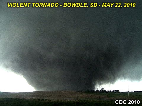
4). May 22, 6:00 PM - Observation and indirect penetration of an extremely severe and violent tornadic thunderstorm in Edmunds County, South Dakota from near Lowry and through Bowdle and to just west of Aberdeen along Highway 12 and points north. This storm was a violent cyclic supercell, starting out as a classic supercell, then evolving to HP during its later stages. At LEAST six tornadoes were produced and observed with this storm, all of them significant. One possibly violent tornado was observed near Bowdle, causing significant damage (if not - total devastation) of some farmsteads north of the town. Transmission powerlines and a radio tower were also destroyed. This tornado was a mile-wide wedge tornado, and was observed from close proximity, with inflow / RFD winds approaching 100 MPH (or more). The storm also acquired the "stacked plates" structure during its early HP stages, with the appearance of an "upside-down wedding cake" at times, with a tornado still on the ground. The backside of the storms core was observed, with winds well over 75-MPH, baseball sized hail, lightning, and torrential rains were encountered (I had to seek shelter behind a farmer's shed). The other tornadoes produced by this storm were cones and stove-pipe type tornadoes. The storm was caused by the interaction of a warm front / boundary, dryline / confluence axis, surface heating, low-pressure area, and an upper trough. Documentation was HD video and digital stills. A 2009 Kia Optima was used to chase the storms. A tornado watch was also valid for the area until 1 AM CDT (the following day).
5). May 23, 5:30 PM - Observation and penetration of a severe thunderstorm south of Oberlin, Kansas in Decatur County along Highway 83. The storm was part of a multicell cluster of strong and severe thunderstorms, and was penetrated in order to reach other more severe storms / supercells to the south. The largest hail associated with this storm was observed to the east of the chase track, with an impressive hail-shaft visible. Conditions observed were 60 to 70 MPH winds, hail up to 1", frequent lightning, and torrential rains. Conditions causing the storms were moisture convergence, a developing low pressure area, dryline to the west and warm-front to the north, surface heating, and an upper trough. Documentation was digital stills and HD video. A 2009 Kia Optima was used to chase the storms. A tornado watch was also valid for the area until 12 AM CDT the following day.
6). May 23, 7:30 PM - Observation of a very severe and tornadic thunderstorm north of Oakley, Kansas from Highway 83 in Thomas County. The storm was an HP supercell storm, and its core was allowed to pass to the west. A large truncated cone tornado was noted on the rain-free base of the storm, which evolved to a smaller tornado before lifting in about 5 minutes. The tornado was observed at a distance of at least 10 miles, but well visible and a report was called in for it to the NWS. The storm core contained hail to about 2" (not penetrated) and frequent lightning was observed as well. Conditions causing the storms were moisture convergence, a developing low pressure area, dryline to the west and warm-front to the north, surface heating, and an upper trough. Documentation was digital stills and HD video. A 2009 Kia Optima was used to chase the storms. A tornado watch was also valid for the area until 12 AM CDT the following day.
7). May 23, 9:00 PM - Observation of an extremely severe and tornadic thunderstorm from southwest of Atwood, Kansas and along Highway 36 in Rawlins County to near Bird City. The storm was another HP supercell storm, also observed from a distance, and two tornadoes were observed in the darkness (illuminated by lightning) from a distance (10 miles or so). One was briefly visible southwest of Atwood and another north of Bird City. The core was avoided but probably contained very large hail. The storm also had an impressive "barber pole" updraft when viewed from the south near Bird City. The storm also was producing nearly continuous lightning (CC and CG). Conditions causing the storms were moisture convergence, a developing low pressure area, dryline to the west and warm-front to the north, surface heating, and an upper trough. Documentation was digital stills and HD video. A 2009 Kia Optima was used to chase the storms. A tornado watch was also valid for the area until 12 AM CDT the following day.
8). May 24, 4:00 PM - Observation and penetration of a very severe thunderstorm along Highway 385 and north of Hemingford, Nebraska in Box Butte County. The storm was an intense cell embedded in a multicell line of storms. Hail to nickel-sized, torrential rains, frequent lightning, and winds gusting over 80-MPH were encountered with this storm. Tree damage was also observed with this storm. Conditions causing the storms were a strong cold front, low pressure area, surface heating, and an upper level low pressure area. Documentation was digital stills and HD video. A 2009 Kia Optima was used to chase the storms. A tornado watch was also valid for the area until 8 PM MDT.
9). May 24, 6:30 PM - Observation and penetration of another very severe thunderstorm from south of Hay Springs near Highway 87 in Box Butte County, Nebraska and eventually north and eastward along Highways 391 and 18 into South Dakota and to as far as Mission, South Dakota. The storm was a multicell line of severe thunderstorms, in which en embedded HP supercell storm was observed early on before evolution to a derecho-like outflow dominant MCS. Hail, torrential rains, lightning, and winds gusting to near 90-MPH were observed with these storms. The strong winds kicked up a lot of dust, and pebbles were blown into my chase vehicle at one point. Some tree and sign damage was also noted. Conditions causing the storms were a strong cold front, low pressure area, surface heating, and an upper level low pressure area. Documentation was digital stills and HD video. A 2009 Kia Optima was used to chase the storms. A tornado watch was also valid for the area until 8 PM MDT.
10). May 25, 4:30 PM - Observation of a severe thunderstorm just west of Johnson City, Kansas and into Colorado just west of the border along Highways 160 / 89. This was in Baca County in Colorado and Stanton County in Kansas. The storm was a small supercell storm which produced a wall cloud and funnel during its high-point. The storm also contained large hail, gusty winds, and very heavy rains. The core was not directly penetrated, so only small hail was observed. Conditions causing the storms were a stationary front / outflow boundary, approaching dryline, surface heating, and an upper trough. Documentation was digital stills and HD video. A 2009 Kia Optima was used to chase the storms. A severe thunderstorm watch was also valid for the area until 10 PM CDT.
11). May 25, 6:30 PM - Observation and penetration of an extremely severe and tornadic thunderstorm from just west of Towner, Colorado in Kiowa County and into Kansas near Tribune and as far as Scott City in Scott County. This cyclic supercell storm was observed from near Highway 96 in Towner and Tribune and also along county roads north of Highway 96. In Sheridan Lake County, Colorado, the developing supercell storm produced at LEAST five land-spout type tornadoes. The storm became a very powerful cyclic supercell storm, and had a large rotating wall cloud when it was west of Towner. Hail at least 2" was also observed north of Highway 96, which completely covered the ground in some places. The storm split, and the main portion continued eastward near Tribune, Kansas, where two more tornadoes were observed. More large hail and high winds were encountered north of Scott City hear Highways 96 and 83. Largest hail observed falling was up to 2" (half dollar sized). The storm also contained frequent lightning and strong winds (near 65-MPH). Hail fog was observed with the hail falls that covered the ground. The storm also produced some spectacular wall clouds, one of them touching the ground! Conditions causing the storms were a stationary front / outflow boundary, approaching dryline (with a triple-point to the stationary boundary), surface heating, and an upper trough. Documentation was digital stills and HD video. A 2009 Kia Optima was used to chase the storms. A severe thunderstorm watch was also valid for the area until 10 PM CDT.
12). May 26, 5:00 PM - Observation and indirect penetration of an extremely severe, and possibly tornadic thunderstorm in Weld / Morgan Counties in northeastern Colorado from south of Interstate 76 near Bennett and east to near Wiggins and Highway 52. The storm was an LP and / or classic supercell thunderstorm. The storm core was not directly penetrated, yet hail up to 2" was observed falling on the edge of the storm core, with an impressive RFD. A brief weak tornado was also observed with the storm near Prospect Valley. The storm had also had the impressive "stacked plates" and striations on the updraft, with a very striking visual appearance during its intense stages. Conditions causing the storm were surface heating, upslope wind flow (lee trough), and an upper trough. Documentation was digital stills and HD video. A 2009 Kia Optima was used to chase the storms. A tornado watch was also valid for the area until 8 PM MDT.
13). May 29, 7:00 PM - Observation and indirect penetration of severe thunderstorms near Highway 2 from near Hyannis to Thedford, Nebraska in Grant and Hooker counties. The severe storms were part of a multicell cluster of storms. The core of the most intense storm was not directly penetrated (contained hail to near 2"), but frequent lightning, heavy rains, 60-MPH winds, and hail to 1" was encountered. The storms began as a multicell cluster of storms (with embedded HP supercells), but quickly became outflow dominant. A funnel was observed on the southern side of the storm to the NE of Whitman, Nebraska. Conditions causing the storms were surface heating, a cold front, weak low pressure area, and an upper trough. Documentation was digital stills and HD video. A 2009 Kia Optima was used to chase the storms. A severe thunderstorm watch was also valid for the area until 11 PM CDT.
14). May 30, 6:00 PM - Observation and indirect penetration of a very severe thunderstorm from north of Nash, Oklahoma in Grant County and southeast into Garfield County near Kremlin near and along Highways 11, 64, and 81. The storm began as a supercell storm (classic) with a wall cloud, then transitioned to an outflow dominant multicell storm cluster of severe thunderstorms. Winds associated with these storms gusted over 70-MPH, with torrential rains, frequent lightning (with some close hits), and hail up to 3/4 inches. The storm core of the supercell was not directly penetrated, and contained hail to golfball (1.75") in size. Some tree damage was also observed with this storm. Conditions causing the storms were surface heating, a slow-moving cold front, low pressure area, upper trough, and dryline / shear axis. Documentation was digital stills and HD video. A 2009 Kia Optima was used to chase the storms. A severe thunderstorm watch was also valid for the area until 12 AM CDT the following day.
15). May 30, 8:30 PM - Observation and indirect penetration of another very severe thunderstorm west of Crescent City, Oklahoma in Logan and Kingfisher Counties near Highway 33. The storm was a supercell storm (classic) with a rotating wall cloud with some brief funnels, and was the "tail-end Charley" southernmost storm in the multicell storm complex (MCS) farther north. The storm core of the supercell was not directly penetrated, but hail to about 1.25" was observed, along with heavy rains, 40-MPH winds, and frequent lightning (with numerous close hits). The main core had hail to tennis-ball sized, and the hail roar / clanking could be heard on the rear-flank of the storm. Conditions causing the storm was surface heating, a slow-moving cold front, low pressure area, upper trough, and dryline / shear axis. Documentation was digital stills and HD video. A 2009 Kia Optima was used to chase the storms. A severe thunderstorm watch was also valid for the area until 12 AM CDT the following day.
This concludes the Chase Log for the US Great Plains and Midwest storm chasing trip from May 18 through June 1, 2010. This chase summary includes a total of 15 severe storm interceptions and / or observations. Out of these observations, a total of at least 20 tornadoes / large funnels were observed. The main chase vehicle conducting all chases is a 2009 Kia Optima (rental). This information was prepared exclusively for the National Weather service and the team of Skywarn storm spotters.
|
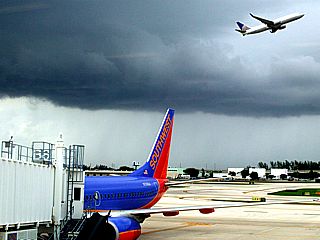
Severe Thunderstorm over Fort Lauderdale airport ... This caused my flight to be delayed nearly two hours. I watched my plane ALMOST land, then fly back out (abort the landing), and later found out they circled, could not land because of the storm, got low on fuel, and had to divert to another airport to re-fuel. This was the flight that I was supposed to be on. Luckily, I had a continuing service connection (no plane change) in New Orleans, so I simply got into Dallas late. |
|
Convective initiation to the northwest of Clinton, Oklahoma as anxious storm chasers watch. |
|
Rapidly developing supercell storm to the northwest of Leedey, Oklahoma over Roger Mills county. |
|
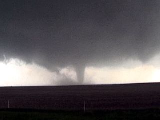
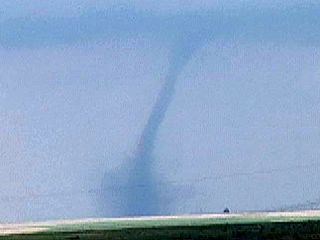
Tornado to the northwest of Leedey, Oklahoma from the rapidly intensifying supercell. The view is west and northwest. |
|
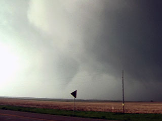
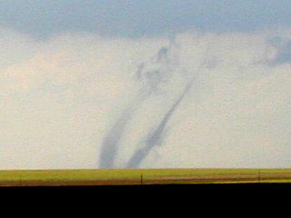
Another possible tornado / rotating wall cloud viewed from west of Eagle City, Oklahoma. The view is to the east. |
|
Rapidly rotating / rain wrapped tornado near Kingfisher, Oklahoma. Visually, this was basically tagging scud really close to the ground. |
|
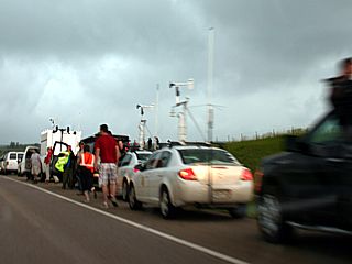
The "chaser convergence" with this storm was insane ... Literally traffic jams of chasers and equipment, including the VORTEX II scientists! |
|
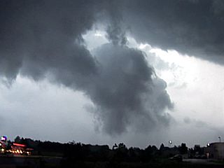
Violently rotating wall cloud over Guthrie, Oklahoma before the storm moved east and weakened. |
|
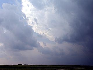
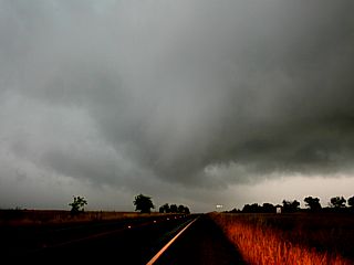
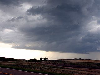
This is a view looking south at the MCS / thunderstorm line from extreme southeastern Oklahoma. The "area of interest" will be at the extreme southwest portion of this line of thunderstorms, to the lower-right in the picture (in NE Texas). |
|
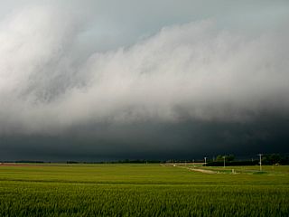
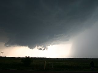
Forward-flank gust front and shelf cloud on the eastern side of an HP supercell near Fairfield Lake, Texas. |
|
Interesting bowl shaped and rotating wall cloud on the inflow side of the HP supercell storm near Fairfield Lake. |
|
Another HP supercell storm west if Interstate 45 (near Wartham, Texas). The view is to the west and northwest. |
|
Rotating wall cloud in the supercell "bear's cage" near Wortham, Texas looking northward and with the rain "hook" behind me. |
|
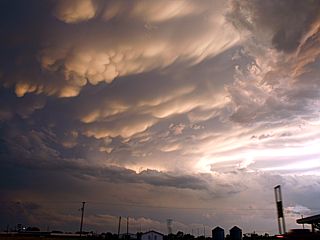
Beautiful mammatus seen from north of the line of supercells on the storm anvil at sunset near Corsicana, Texas. |

|
Here is a "storm chaser's worst nightmare" ... Waiting for the pilot car in a suprise long construction delay along Highway 385 in Northeastern Colorado north of Burlington. Not something any chaser rushing to a storm 100+ miles away wants to see. This delay pretty much tanked the chase for May 21. |
|
Here is a view of the tornadic supercell in far east-central Wyoming / western Nebraska from at least 100 miles away in SW Nebraska. |
|
Convective initiation northeast of Pierre, South Dakota near the intersections of Highways 83 and 14. We watched this develop from blue sky just an hour prior. Believe it or not, this innocent looking cloud will be a violent supercell in about an hour, producing multiple tornadoes. |
|
Here is a picture of the developing supercell southwest of Lowdy, South Dakota during its early stages. |
|
The same storm develops an impressive and rapidly rotating wall cloud. |
|
Developing and rapidly intensifying tornado to the west of Bowdle and southeast of Java near Highway 12. |
|
Multi-vortex tornado evolving to a violent stovepipe south of Highway 12 and west of Bowdle. |
|
Possible satellite / old meso (or left split) tornado to my northwest just as the main (intensifying) tornado is about to cross Highway 12 to my east. |
|
Developing wedge tornado crossing Highway 12 west of Bowdle. The "Dominator" vehicle (Reed Timmer) is INSIDE this tornado as I was taking this picture! |
|
Tim Samaras's main vehicle (with TWISTEX) to the left side of Highway 12 (looking east) and a new in-situ tornado instrument (trailing red marker smoke) that measures tornado winds at 0.7m and 2m to the right. The tornado is just to my north and out of frame to the left. |
|
Multi-vortex stage of the tornado just to my north (on Highway 12) and west of Bowdle, SD. |
|
This has to be one of the most impressive RFD (Rear Flank Downdraft) clear-slots I have ever seen! The violent wedge tornado is to the far right. You can actually see blue sky and crepescular rays of sunlight through the RFD cleat slot. |
|
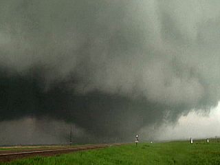
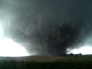
Fully developed and violent wedge tornado just north of Bowdle, SD. The farmstead in the forground sustained serious damage. |
|
The arrow in this picture points to a pickup truck with its headlights on ... This was a resident of the farmstead, with his family and his dog, fleeing for their lives and escaping certain death. I spoke to these folks a day later and they said "We had a choice: Cellar or leave - We chose 'leave'!" |
|
Some flying debris, actually parts of a roof, clearly airborne in this close-up shot of the wedge tornado's southern edge north of Bowdle. |
|
Power flash as the wedge tornado reaches and destroys ultra-high voltage transmission lines. |
|
Tornado crossing the farm road north of Bowdle as other chasers watch in awe. |
|
The violent supercell storm cycles again and the new mesocyclone produces another cone tornado (evolved to a stove-pipe) east of Bowdle as viewed from Highway 12 (the view is northeast). |
|
Absolutely INSANE supercell structure north of Ipswitch with a weakening tornado to the extreme lower left of the picture. |
|
This is a picture of some of the damage to a farmstead (totally destroyed) north of Bowdle, South Dakota a day after the tornado hit. We had to be escorted by the local sheriff and had permission from the owners to take these pictures. Myself and the TWISTEX chase group were conducting the damage survey in the morning before leaving South Dakota for a target area in NW Kansas. |
|
Here is the anvil of a cluster of severe thunderstorms looking south from Highway 83 near the Kansas / Nebraska border. These storms began as multicell, but evolved to supercells once upper level support / low-level dynamics arrived. |
|
Here is a truncated cone tornado viewed from north of Oakley, Kansas and west of Highway 83. This tornado was spawned by an HP supercell storm that was a left split from a seemingly more intense southern (right) split. Myself and chaser Dan Shaw were some of the only chasers who saw this, and we reported it to the NWS. |
|
Here is another view of the tornado west of Highway 83 by about 10 miles and north of Oakley, Kansas just before lifting. |
|
Another HP supercell, also tornadic, produced large amounts of lightning to the southwest of Atwood, Kansas after dark. |
|
This is a view west towards what appeared to be a developing supercell storm, but was the start of a line of thunderstorms. The view is to the west from the Nebraska / South Dakota border and south of the Pine Ridge Indian resrvation. |
|
Here is a picture of the backside and hail shaft (with an interesting funnel shaped silhouette in the center of the picture) from a supercell storm embedded in a developing squall line near Alliance, Nebraska. |
|
Once the storms in NW Nebraska evolved into a powerful squall line, outflow winds gusted over 80 MPH in some places, raising dust as in this picture. |
|
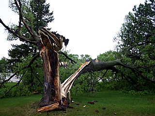
Here is a downed tree after the squall line passed through Valentine, Nebraska. |
|
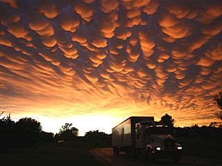
Incredible display of mammatus clouds over Valentine, Nebraska an hour or so after passage of the squall line. |
|
Here is a view of a developing supercell storm in Sheridan Lake County, Colorado. The storm is developing on the intersection of the dryline (left) and a stationary boundary (left to right) called a "triple point". Look very closely to the lower left and you can see one of the first land-spout type tornadoes I observed with this storm! |
|
Here is a picture of the second land-spout type tornado I observed with this supercell in Sheridan Lake County. This tornado developed a bit closer to the supercell than the one pictured above. |
|
Yet another large land-spout tornado develops in Sheridan Lake County. This is tornado number three for me, and this one has a expansive dust cloud at its base. |
|
These are two land-spouts ocurring simultaneously, and "dancing" around each other. They were roughly a half mile apart, and ocurred just before land-spout in the picture above lifted (to the right and out of this picture) - This makes my tornado count for this storm four and five! |
|
The supercell storm in Sheridan Lake County, Colorado had a wall cloud literally scraping the ground! |
|
Here is a picture of the hail-fall northwest of Towner, Colorado. The ground is completely covered with hail ranging from marble sized to half-dollar. Note the eerie hail fog hanging in the air. This storm dropped the temperature from 85 degrees to 45 in about 5 minutes! |

|
Nice piece of golf-ball sized hail. This was probably more like 2" as it has melted quite a bit. |
|
Another tornado develops from the supercell right-split north of Tribune, Kansas. This is the sixth tornado I observed from this storm. |
|
Beautiful narrow tornado develops between Selkirk and Leoti, Kansas. This is tornado number seven from this supercell I observed. |
|
This is a picture of one of the storm chasing tour groups watching the supercell rain-free base and wall cloud. |
|
Here is a picture of an approaching hail core (with green hue) north of Scott City, Kansas and along Highway 83. The view is to the southwest just before getting slammed with golf-ball sized hail. |
|
Here is a view of the developing supercell storm from about 25 miles to the northeast on I-76 (looking southwest). This storm initiated off the Palmer Divide (NE of Denver) and began moving northeast. |
|
Rapidly rotating wall cloud north of Bennett, Colorado. |
|
I think this was a weak tornado that breifly formed, resembling rotating scud. This was northwest of Prospect Valley, Colorado and not far from Bennett. |

|
This supercell produced hail over 2 inches, with smaller marble sized hail covering the road as seen here. My vehicle had dents from this very hard hail (I saw golfball sized), and it cracked the driver's side mirror. |
|
View of RFD clear slot directly overhead from the edge of the hail core of the intensifying supercell near Prospect Valley, Colorado. |
|
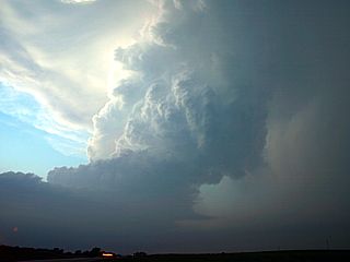
Incredible storm structure of the LP / Classic supercell when it was exiting Weld County and entering Morgan County, Colorado. |
|
Some of the V2 (VORTEX II) personnel with a DOW (Doppler On Wheels) type truck scanning the supercell storm south of Wiggins, Colorado. |
|
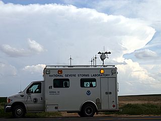
One of the National Severe Storms Laboratory research vehicles with another distant supercell storm in the background. |
|
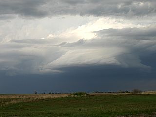
This is a view back towards the weakening supercell storm with a high base and RFD slot still visible to the left. |
|
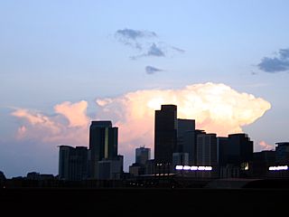
This rather long chase day ended with a stay in Denver, Colorado for the night. Here is the Denver Skyline with a distant supercell thunderstorm (Near Pueblo) looming in the distance. |
|
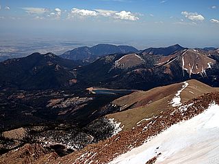
My first, and well deserved "off day" for this trip was spent at Pikes Peak. This peak is over 14,100 feet above sea level. Conditions at the mointain base were light winds out of the SE and 90 degrees. At the summit, temperatures ranged from 30 to 45 degrees, with a stiff SW wind gusting over 50 MPH (72 MPH early in that morning). Weather was crystal clear with high base clouds, allowing a view spanning hundreds of miles. |
|
Here is the view looking south from along Highway 20 near the Nebraska / Wyoming border during the off / reposition day of May 28. Wide open spaces - The wild west! |
|
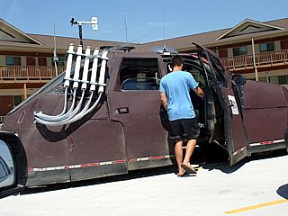
This is a picture of the Dominator (similar to Sean Casey's tornado intercept vehicle), but designed and operated by the Tornado Videos (TVN) network. Designer and meteorologist Reed Timmer is standing in the blue shirt. Note the air cannon package, which is designed to launch parachite-borne instruments into a tornado / supercell updraft. |
|
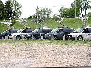
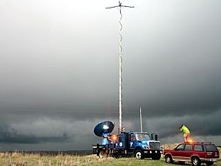
These are the "probe" vehicles, each with a mobile mesonet (weather instrumentation), preparing for a chase in Hyannis, Nebraska. These vehicles are part of the VORTEX II project, operated by the NSSL (National Severe Storms Laboratory). |
|
A severe thunderstorm develops ahead of the approaching cold front to the east of Hyannis, Nebraska and briefly acquires HP supercell characteristics before being undercut by the outflow. |
|
The severe thunderstorm east of Hyannis and near Whitford, Nebraska produced this funnel cloud and weak RFD as viewed from Highway 2. The view is to the north. |
|
Here is one of the DOW (doppler on wheels) radar trucks operated by the NSSL for the VORTEX II project as a severe thunderstorm approaches. Storm chase Jim Reed is standing on the SUV in the yellow rain jacket taking pictures. |
|
Todays target was in north-central Oklahoma near the intersection of a wind-shift line ands a stalled cold front, and the soouthernmost cells in a squall line stretching into Kansas were the storms of interest. In this picture, an intense cell fires north of Vance Air Force Base, Oklahoma. |
|
The severe thunderstorm cell north of Vance Air Force Base briefly becomes a supercell storm, producing a wall cloud, before being under-cut by the outflow / slow-moving cold front. |
|
This is a picture looking up at a weak forward-flank mesocyclone as the supercell storm evolves to a multicell line near Nash, Oklahoma. |
|
This is the wall cloud associated with another supercell storm on the southern-most portion of the line / cluster of severe thunderstorms near Crescent City, Oklahoma. These storms are called the "tail-end Charley" supercells. |
|
Another view of the wall cloud associated with the supercell west of Crescent City, Oklahoma with amazing lightning. |
|
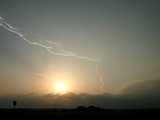
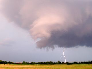
Funnel cloud and another CG lightning strike west of Crescent City, Oklahoma. |
|
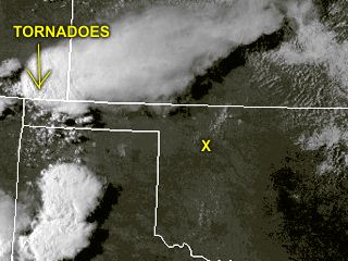
This was the last full day available for chasing, but the storms developed too far away in order to make the target and / or make it back in time for my return trip the following day. The yellow "X" is near Woodward, Oklahoma, and that's the closest I was able to get to the storms without driving without sleep and / or missing my flight out of Dallas, TX on June 1. These storms produced MULTIPLE tornadoes in SE Colorado. |
|
Here is a picture of some flashes of lightning from a distant thunderstorm over the Gulf Of Mexico while en-route from Houston, Texas to Fort Lauderdale, Florida on the return-flight at the end of my trip. |
HTML File "mwcl2010.htm" - Developed By Chris Collura
To Return To The HOME Page Of This Site Click The "INDEX.HTM" Link Here!