
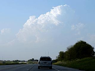
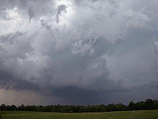
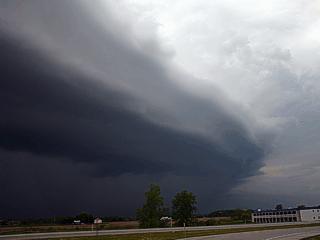
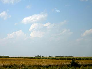
| This section is for storm chases done in the central / Midwestern United States during the year of 2006. This includes all storm chasing activities (including any major chase "expeditions") during the year of 2006 in the central USA (aka "Tornado Alley"). For 2006, all chases in the central USA will be logged in this section, with many of the chases being possible "spot" chases / major severe weather "setups" chased. This includes the main chase expedition trip from May 17 through May 31 of 2006 and any subsequent trips to these areas over the summer and fall of 2006. The months of May and June of 2006 were rather quiet, with more activity occurring in the early fall during the "second season" of this year. This is my seventh year chasing in the Central USA for severe weather. Here you should find many pictures of lightning, possible tornadoes, along with many severe thunderstorm elements. Keep in mind that this chase log is scientific evidence and portrays my on-going storm chasing research. It has been placed on this page for easy reference and meteorological interests. |
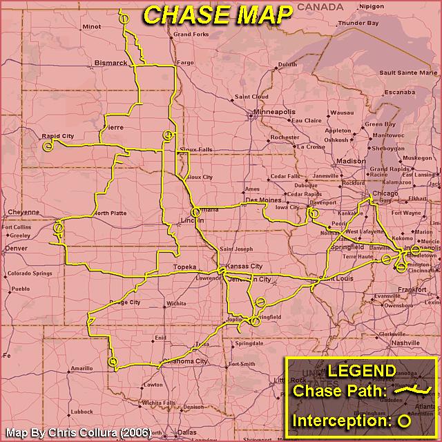
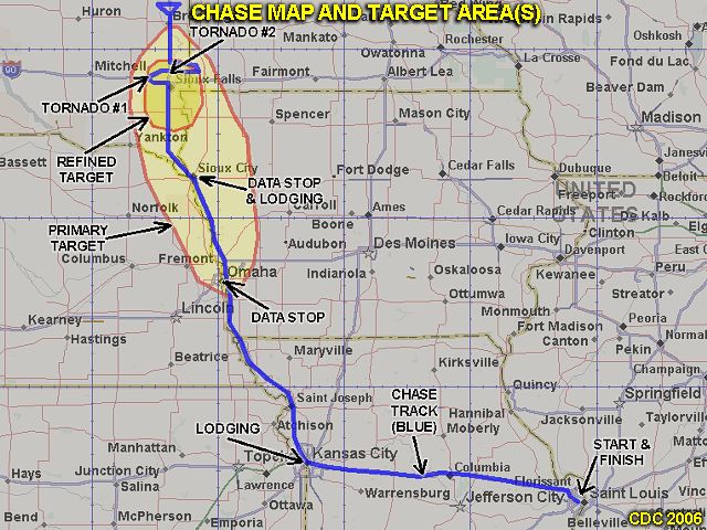
The map above shows how much territory was covered by myself chasing solo in the central United States during Chase expedition 2006. Yeah! I do "get around" - About 12 states were covered (note that the flight from Dallas, TX to Oklahoma City, OK is not shown) over a period of 15 days. The paths traveled are in yellow lines and the yellow circles are where storms were intercepted. An incredible area was covered, stratching from southwestern Oklahoma and northeastern Colorado eastward to western Ohio as well as from central Oklahoma northward to extreme northern North Dakota at the Canadian border! There was a total of 15 travel days, of which, 14 of these days were available for chasing (day 15 was a travel day). In these days, there was 9 chase days, 5 travel / down days, and 1 "bust" day. The storm intercept team involved this year consisted only of myself and was be "based" out of Oklahoma City, Oklahoma where I flew out to on May 17, 2006 and chase until May 31, 2006.
| CHASER NAME | HOME CITY | CALLSIGN | CHASE DATES | OCCUPATION |
| CHRIS COLLURA | MIRAMAR, FL | KG4PJN | 5-17 TO 5-31 | IT CONSULTANT |
The participants below often actively participate in our storm research efforts and deserve appreciation for their great help and severe weather expertise.
| CHASER NAME | HOME CITY | CALLSIGN | OCCUPATION |
| ALEX DWALL | N/A | KC8RHE | AIRLINE PILOT |
| DAVID DIEHL | CHICAGO, IL | KC9BXX | IT |
| RICH CENCI | N/A | N/A | AIRCRAFT FBO |
| TONY LAUBACH | DENVER, CO | KW0LFF | STUDENT |
| VERNE CARLSON | DENVER, CO | KB0ZCQ | IT |
Please note that several other chasers may caravan or "converge" with us.
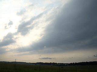
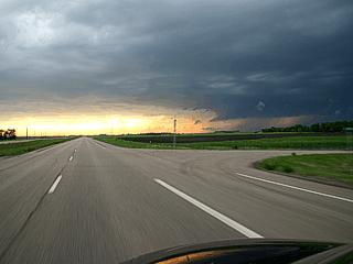
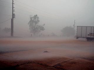
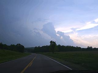
May 17 - Arrival day. Arrived at Oklahoma City and picked up rental vehicle. Anticipating a few days of "down time" (no storms) I decided to head east on I-44 to spend the night in St Louis, Missouri. The only possibility of weak convection also happens to be in and east of the St Louis area before activity returns to the high plains in a few days.
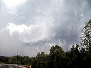
May 18 - Today was expected to be a total down day which the first half of which was spent in Saint Louis, Missouri killing time. By afternoon, convection began east of the area with enhanced cumulus developing. After checking data and seeing an upper air disturbance moving across eastern and central Illinois and into Indiana, I decided to investigate any convection that might develop. In low dewpoint air, and despite a stiff northwest flow at the surface and aloft, some strong thunderstorms did get going, one of which was intercepted on Interstate 70 near Brazil, Indiana. Time-lape video was also produced for the remainder of the convection. Day was wrapped up for the night in Indianapolis, Indiana. This was the farthest east I ever chased and plans are to head back west for activity in a few days back in the high plains.
May 19 - Down day, with only slight chase prospects dwindling in the extreme southern portions of Illinois and Indiana, I decided to kill more down time with a visit and stay over in Chicago, Illinois since it was about 3 hours northwest of Indianapolis. I also forecasted and found that portions of MO and Kansas may have fair to good chasing prospects for the next day (May 20).
May 20 - Cap bust day. I decided to gamble by side tracking into SW Missouri near Cassville off Interstate 44 (since I had to head back west anyways) after seeing a moderate upper-air impulse sliding SE in the NW flow aloft with a pocket of high CAPE and boundary enhanced helicity (from a stationary front across southern MO) in that region. The only thing was the 700 mb temperatures were too warm, and a capping inversion held solid from the NE side of a 500 mb thermal ridge (to my SW). Waited for any signs of development until about 6:30 PM CDT and nothing happened, despite nearly a 20 degree difference (92 in Cassville with SW winds and 73 near Carthage with SE winds, 40 miles apart). Only elevated showers were observed north of the boundary due to the upper-air disturbance and associated large-scale ascent. Headed north on highway 77 and spent the evening in Harrisonville, MO. The next day (5-21) may be a chase day in western Kansas based on looking at data that evening of May 20.
May 21 - Chase day with two thunderstorms intercepted, one a supercell near Springfield, MO and the other a strong multicell storm near Plad, MO. Today had a nearly identical setup as the one on 5-20 near Springfield, MO so after much forecasting I decided to target that area rather than head west. This time, the cap was overcome since a mid-level MCV was rotating eastward out of central Kansas and two boundaries were in place over the target area. After the interception(s), I headed back to Salina, KS for the night anticipating a drive farther west on 5-22 for possible upslope convection in NE Colorado / NW Kansas.
May 22 - Today was a chase day with good potential which did not come together fully. Began the day by leaving Salina, Kansas after looking at data and forecasting a region of convergence / upslope in NE Colorado / NW Kansas under an approaching shortwave. Headed northwest on Interstate 70 then north to first target area of Wray, Colorado near the tri-state regions of CO, NE, and KS. Storms did develop in that region, but were very high based as dewpoints never reached that region and the upper dynamics had not cleared the Rocky Mountains in time. The storms were strong thunderstorms, one exhibiting weak rotation, but did not get organized. Met up with several other chasers, including Brian Morganti and Jeff Pitrowski and even did a demo of my equipment / interview for a Brazilian film crew riding along with Brian's group. Headed back east to North Platte, NE for dinner and to spend the evening as the next day (5-23) should be another chase day farther east in Nebraska along Interstate 80.
May 23 - Chase day in southeastern South Dakota where high chase prospects wound up with an outflow dominant squall line and many intense gustnadoes. Left North Platte after forecasting and found the best target to be near Chamberlain, South Dakota and nearby areas to the southeast along Interstate 90. Initiation of storms began as expected in the target area by afternoon and continued eastward along Interstate 90 where I met up with other chasers including Tony Laubach near Kimball, SD. The storms became linear and with very strong outflow winds, but a fantastic spree of gustnadoes was caught not far from Letcher, South Dakota ahead of the squall line. The storms encountered also had strong winds and heavy rains. The chase track played the squall line looking for circulations and forward-flank mesocyclones in the gust front. Todays long chase track, once out of Nebraska and into South Dakota, contined east along Interstate 90 into extreme SW Minnesota, then south on Highway 75 into Iowa where Tony Laubach and myself spent the night in Sioux City, Iowa.
May 24 - Today was a long chase day which began early with a forecast that targeted east-central Iowa and west-central Illinois. Tony Laubach and I left Sioux City, Iowa and headed south on Interstate 29 then East on Interstate 680 and 80. We passed Des Moines, Iowa then dropped southeast on Highway 163 into Ottumwa, Iowa where we checked data and met up with a few other chasers. We continued east on Highway 34 into Illinois. With another check of data, we continued to Galesburg, Illinois then north on Interstate 74 to finally intercept developing storms southeast of Moline, Illinois. The storm briefly became a small supercell near Rock Falls, Illinois before splitting and evolving into a multicell line and gusting out. We headed southeast on Highway 52, then to Interstate 39 to wrap up the day with dinner and lodging in Bloomington-Normal, Illinois.
May 25 - Another chase day beginning with Tony Laubach and myself forecasting and targeting east-central Indiana from Indianapolis to the Ohio border as tghe primary target. We left Bloomington-Normal, Illinois and headed east into Indiana towards Indianapolis and stopped at an exit off Interstate 70 where we met another chaser, David Diehl. We continued south towards Eminance, Indiana then towards Bloomington where the first tornado-warned supercell storm was found near Elletsville, Indiana producing small funnel clouds. The storm merged into a squall line so we headed back north and around to the east side of Indianapolis to try to get ahead of the storms, but they became linear and outflow dominant. We continued to the Ohio state line and ended the chase there. I continued back west towards Inidianapolis as Dave and Tony split apart as well. As I continued west, I encountered another severe storm with a spectatular shelf cloud (also outflow dominant) near Interstate 70 near Spiceland, Indiana. The storms continued to become linear, and I wrapped up the day spending the night in Indianapolis,l Indiana.
May 26 - Today was taken to be a travel (down) day to re-position farther west anticipating the next disturbance moving into the high plains. Left Indianapolis, Indiana and headed west on Interstate 70 most of the day and spent the night in Kansas City on the Kansas side. The original plan was to pass "down time" in Chicago, Illinois but plans changed as the rule was to head west. Unfortunately, major storms were missed this day in the western Kansas region as the "new" disturbance was much stronger than forecasts and models depicted. The next day should have activity and Kansas City at least puts any new chase prospects in range.
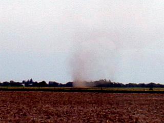
May 27 - Today was a long shot, a real long shot, which began with a forecast pinpointing the best chance of tornadoes and severe storms in northeastern North Dakota, and I made the trip. I left Kansas City, Kansas at 8:30 AM and headed up highway 29 through Kansas / Missouri, Omaha, Nebraska (where some strong storms were passed by), Sioux City, Iowa then into South Dakota and North Dakota choosing Fargo, North Dakota for the first target. The trip took about 7 hours, and I was in Fargo by 3:30 PM. Upon checking data, the best dynamics and chance of initiation (enhanced cumulus revealed by visible satellite) was about 100 miles to my west, so I headed west on Interstate 94 and found a line of towering cumulus far off to my NW. I headed north on Highway 231 out of Jamestown, North Dakota as the towering cumulus developed into a distant building supercell storm. This storm happened to be NW of Devils Lake, and was intercepted sucessfully with large hail and a rotating wall cloud / funnels. I also decided to go the extra 20 miles to the Canada border before returning to Jamestown, ND for the night as the next day will be a chase day farther south. This day was, put aside hurricane chases, the longest chase ever in my life!
May 28 - Chase day with severe storms intercepted in SW South Dakota. Forecasted in Jamestown, North Dakota to determine today's target area. There were two prospects, one again in northeastern North Dakota (departing surface low) and another in southwestern South Dakota (lee cyclogenesis was a possibility). If the low did not develop SW of South Dakota and the low in NE North Dakota did not move, northeastern South Dakota would have been good for possible storms. I left Jamestown and targeted Aberdeen, South Dakota. Here is where I waited for quite a while, watching the SE winds there quickly go SW as a cold front surged past Pierre to my west. Meanwhile, agitated cumulus appeared on the visible satellite in both NE North Dakota and SW South Dakota, nothing in my area. After another hour or so, the cumulus to the SW kepts building, and was in far better upper-air dynamics, plus slowly backing winds, despite it being in the post-frontal air. There was a very strong cap, and that helf off anything in ND (although an isolated cell fired there). I decided to go with SW SD so I headed southwest to Pierre, then targeted Kadoka, South Dakota. Storms were building rapidly to the southwest, and finally, a violent storm (hail and high winds) was intercepted near Wanblee in the Pine Ridge Indian reservation. After intercepting the storm, it was then a long drive through severe weather along Interstate 90 until west of Kennebec, where it cleared. The night was spent in Chamberlain, South Dakota as the next days chase prospects are SE Nebraska / NE Kansas.
May 29 - Today was supposed to be a chase day farther southeast (NE Kansas / SE Nebraska) but a cold front surged ahead of all the good upper air dynamics, so a long travel day (but trying to play along the front) from Chamberlain, South Dakota down into northeastern Kansas through southeastern Nebraska, then southwest into Liberal in SW Kansas anticipating a good setup for storms on 5-30. Managed to document some dust devils in eastern Nebraska, convection along the stalled cold front in NE Kansas, as well as very interesting dryline induced convection farther in SW Kansas. Also stopped in Hallam, Nebraska along the way to check out how the town was doing after a tornado destroyed it 2 years prior on May 22, 2004. I was delighted to see most of the town rebuilt. Met up with Verne Carlson and Tony Laubach in Liberal to share a room for the night.
May 30 - Chase day in western Oklahoma area. Forecasted and left Liberal, Kansas targeting development southwest of Woordward, Oklahoma. This was a dryline type setup with an outflow boundary and stationary front to play with. An upper air disturbance passed over the target region with an increase in upper winds in the right-rear entrance region of the jet stream flow. The storm was a supercell storm that was followed down and west of Highway 283 from near Cheyenne, Oklahoma to Interstate 40 until it gusted out violently.
May 31 - Departure and travel day. No storms were intercepted today or were in range. Returned the rental vehicle and left Oklahoma City, OK to return to Fort Lauderdale, FL.
1). May 18,4:00 PM - Penetration of strong thunderstorms along Interstate 70 just west of Brazil, Indiana. The storms were high-based but produced very heavy rains, small hail, 40-MPH winds, and occasional lightning. The storms developed in a region of strong northwest flow aloft on the backside of a departing upper-level low pressure system. Surface heating and an upper level trough triggered the storms. Documentation was HD video (time lapse) and still images. A 2007 Ford Focus was used to chase the storms.
2). May 21,4:30 PM - Interception of a very severe thunderstorm on the east side of Springfield, Missouri near Interstate 44 and Highway 65. The storm was a classic to LP type supercell storm, which lasted about an hour but dissipated rapidly after moving south of a boundary it developed on. The storm produced heavy rains, 40-MPH winds, and hail to 3/4". Strong rotation was noted with the storm, with some small funnels, an RFD notch, and beautiful "stacked plate" effect on the storm updraft. A low pressure trough, surface boundary interactions / fronts, surface heating, and mesoscale low-pressure area caused the storms. Documentation was HD video and digital stills. A 2007 Ford Focus was used to chase the storm.
3). May 21,4:30 PM - Penetration and observation of a strong thunderstorm near Plad, Missouri along highway 64. The storm was the western most part of a multicell cluster of strong thunderstorms. The storm produced heavy rains, 30-MPH winds, and hail to 1/2". A low pressure trough, surface boundary interactions / fronts, surface heating, and mesoscale low-pressure area caused the storms. Documentation was HD video and digital stills. A 2007 Ford Focus was used to chase the storm.
4). May 22,6:30 PM - Observation of a strong thunderstorm in far northeastern Colorado near the tri-state regions of Colorado, Kansas, and Nebraska along highway 45 / 385. The strong thunderstorm was high based, but developed a weak precipitation core and had very weak rotation before falling apart. The core of the storm was not intercepted. An area of surface convergence, upper trough, upslope orographics, and surface heating produced the storms. Documentation was HD video and digital still photos. A 2007 Ford Focus was used to chase the storm. A severe thunderstorm watch was also in effect for the area until 10 PM CDT.
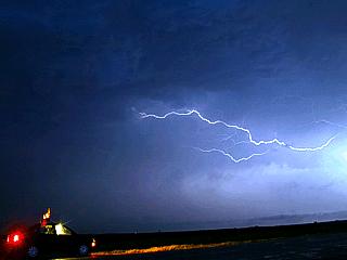
5). May 23,5:00 PM - Penetration of severe thunderstorms and obervation of strong gustnadoes along their gust fronts from near Letcher, South Dakota southeastward as far as western Iowa. The storms were a multicell line of strong and severe thunderstorms and contained wind gusts to 70-MPH with frequent lightning, small hail, and heavy rains. The gustnadoes developed ahead of the line of storms and a few became quite strong (damage observed was tree damage). A low pressure trough (surface and aloft) and surface heating produced the storms. Documentation was HD video and digital stills. A 2007 Ford Focus was used to chase the storms. A tornado watch was also in effect for the area until 9 PM CDT.
6). May 24,7:30 PM - Observation and indirect penetration of a severe thunderstorm near Rock Falls, Illinois along Highway 52 and farther southeast towards Amboy, Illinois. The storm was a small supercell storm that developed at the southern extent of a multicell line of storms. The storm contained lightning, heavy rains, small hail, and wind near 40-MPH where it was penetrated (through a split in the storm). The storm produced quarter-sized hail but the hail core was not deeply penetrated in this storm. A low pressure trough (surface and aloft), cold front, and surface heating produced the storms. Documentation was HD video and digital stills. A 2007 Ford Focus was used to chase the storms. A tornado watch was also in effect for the area until 8 PM CDT.
7). May 25,4:30 PM - Observation a very severe thunderstorm near Elletsville, Indiana near Highway 46. This storm was a small but briefly intense supercell storm with a wall cloud and small funnels produced. Tornado sirens were sounded for the city of Elletsville. The core of the storm was not penetrated, but 40 MPH inflow winds were observed. The storm quickly merged with other storms and formed a multicell squall line. A low pressure trough (surface and aloft), cold front, and surface heating produced the storms. Documentation was HD video and digital stills. A 2007 Ford Focus was used to chase the storms. A tornado watch was also in effect for the area until 10 PM CDT.
8). May 25,7:00 PM - Observation and indirect penetration of a severe thunderstorm north of Spiceland, Indiana north of Interstate 70. The storm was part of a multicell line of strong and severe storms. The storm contained lightning, heavy rains, small hail, and wind near 40-MPH where it was penetrated. A low pressure trough (surface and aloft), cold front, and surface heating produced the storms. Documentation was HD video and digital stills. A 2007 Ford Focus was used to chase the storms. A tornado watch was also in effect for the area until 10 PM CDT.
9). May 27,9:30 AM - Penetration of strong thunderstorms along Interstate 29 south of Omaha, Nebraska just east of the Iowa / Nebraska border in Iowa. The storms were encountered while traveling north, and were elevated multicell cluster type storms. Heavy rains, lightning, and 40-MPH winds were encountered. A upper low pressure trough and left-over convection / outflow boundaries due to an overnight MCS produced the storms. Documentation was digital stills. A 2007 Ford Focus was used to chase the storms.
10). May 27,8:00 PM - Observation and penetration of a very severe thunderstorm in Towner County, North Dakota near Cando along and near Highway 231. The storm was a high-based supercell storm that organized into a tornado-warned (radar indicated) HP supercell storm. The storm had winds over 60-MPH, frequent lightning, heavy rains, and large hail to 1" (quarter sized), although reports of 3" came from nearby (this size was not encountered). A large rotating wall cloud was also observed with this storm, but only some small funnels were produced. A low pressure trough (surface and aloft), stationary front, and surface heating produced the storms. Documentation was HD video and digital stills. A 2007 Ford Focus was used to chase the storms. A tornado watch was also in effect for the area until 12 AM CDT.
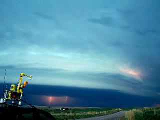
11). May 28,9:30 PM - Observation and penetration of an extremely severe thunderstorm near Wanblee, South Dakota in Jackson County in the Pine Springs Indian reservation near highway 44 and Highway 73. The storm was an HP supercell type storm that was on the northern end of a powerful bow-segment in a cluster of severe thunderstorms. This storm had an impressive visual appearance with inflow banding and "stacked plates" appearance on the north "rotating head" cell with a multi-tiered shelf cloud extending southward along the bow segment. The storm did have a wall cloud and rotation, and a tornado warning (radar indicated) was issued for the storm between Wanblee and Long Valley. As the storm approached, 60 to 70-MPH outflow was observed. Conditions in the precipitation core were torrential rains, nearly continuous and frequent lightning, golfball-sizd hail, and winds near 70-MPH. The tornado was not observed since I backed away from penetrating the storm core. Power was knocked out in the town of Wanblee. This storm traveled to the northeast and became a multicell cluster and still produced hail to quarter sized with 65-MPH winds, which was again encountered northeast near Okaton and Murdo along Interstate 90. Power was out also in several towns along Intertstate 90 and a semi-trailer was nearly blown off the road. The storms were caused by an upper trough / jet stream exit region, surface heating of a post-frontal air mass, and developing surface low pressure. Documentation was HD video, audio, and digital stills. A 2007 Ford Focus was used to chase the storms. A severe thunderstorm watch was also in effect for the area until 1 AM CDT.
12). May 30,6:30 PM - Obervation and indirect penetration of an extremely severe thunderstorm from west of Cheyenne, Oklahoma southward along and west of Highway 283 to Interstate 40. This storm had confirmed softball-sized hail, ofcourse that portion of the storm was avoided, abeit close. Upon penetrating the fringes of the storm core, hail to the size ping-pong balls was observed, with torrential rains, frequent lightning with close hits, and 65 to 70-MPH winds. The storm also produced several funnel clouds and had a rotating wall cloud for some time. When the storm gusted out, winds well over 75-MPH were onserved just north of Interstate 40. Tree and sign damage along with flooding ocurred with this storm. The storms were caused by an upper trough / jet stream entrance region, surface heating, dryline, and stationary front / outflow boundaries. Documentation was HD video and digital stills. A 2007 Ford Focus was used to chase the storms. A severe thunderstorm watch was also in effect for the area until 10 PM CDT.
This concludes the Midwestern United States Chase Log for the first trip in May 2006. The summary includes a total of 8 severe thunderstorms, 4 strong thunderstorms, and 2 tornadoes / funnel clouds. The main chase vehicle conducting all chases was a 2007 Ford Focus rental. This information was prepared exclusively for the National Weather service and the team of Skywarn storm spotters.
|
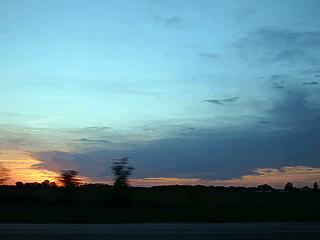
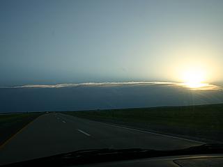
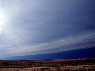
A sunset over western Missouri can be seen while traveling from Oklahoma City, OK to St Louis, MO along I-44. Storms did not develop in these areas, except for the high clouds in this picture, produced from the western edge of a low pressure area aloft. |
|
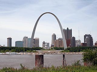
Here is a picture of Saint Louis, Missouri taken from the Illinois side of the Mississippi River showing the 630 foot high Arch Monument. This day had no storms expected and time was spent in the city checking a possible job opportunity there and shopping for food / supplies. This day, however, did become an unexpected chase day as far east as central Indiana by evening. |
|
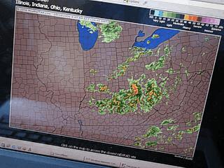
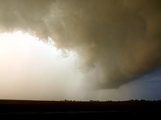
Thank God for WiFi! Here is the Weathertap Radar screen when stopped for data off Interstate 70 in west-central Indiana. An upper-level low pressure area is causing storms to erupt in afternoon heating despite cool surface temperatures, NW winds, and low dewpoints. |
|
Here is a developing region of enhanced cumulus (although its base is rather high) in Central Indiana off Interstate 70. These clouds eventually grew into low-topped thunderstorms. |
|
The developing storms in Central Indiana had small but stout rain free bases. The one here has scud rising up into it. Interesting to see this develop in a true cold-core environment. |
|
In this picture you can see a hail shaft (center) associated with one of the cold-core storms. Hail to pea sized was produced by the storm in this picture. The NW flow aloft and at ground level causes convection despite 60 degree surface temperatures because the freezing level is low (only 10,000 feet or so) and yeilds steep lapse rates. |
|
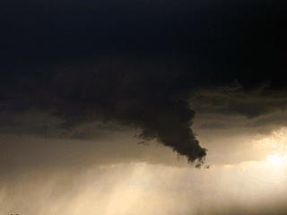
A small funnel, called a cold-air (or cold-core) funnel, slowly turns on the rear flank of an updraft developing north of Interstate 70 in central Indiana near Brazil. The view is to the north. These are generally weak, like the one in the center of this picture. |
|
Cold-core storms often weaken quickly, and the cell peters out and weakens with a glaciated anvil southeast of Brazil, Indiana. Note that the convective cell is both high based and low topped. The view is due south. |
|
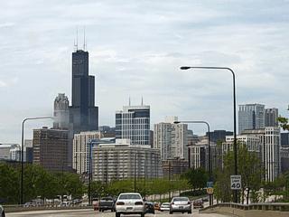
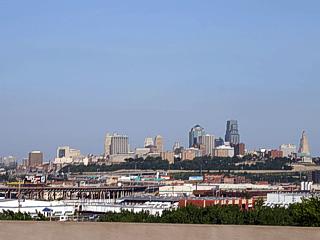
Not much in the way of storms again, but looking better with each model run, so today was spent poking around Chicago's Lakefront Drive to pass more "down time". I took the picture above while driving northwards towards Navy Pier on Lakeshore Drive of the downtown Chicago skyline. |
|
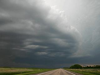
Here is a picture of Altocumulus Castellanus (ACCAS) clouds over southwestern Missouri as a region of upper lift moves over the area. This indicates instability aloft, but there is a cap (temperature inversion) below this feature, so surface based convection (storms) never developed. Note the clearer air to the lower-left (looking SW) as the edge of a 500 mb thermal ridge aloft erodes the cloud deck due to sinking air (subsidence). |
|
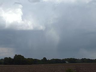
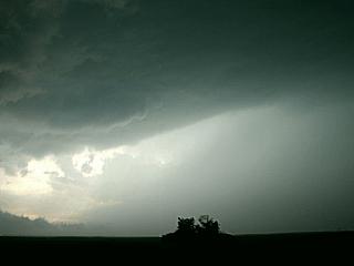
This is a picture of virga (precipitation aloft) falling from elevated showers in western Missouri. This type of convection and associated precipitation is above the surface and also above any capping inversion, hence the term "elevated". Sometimes you can see sporadic and small flashes of cloud to cloud lightning in these clouds. |
|
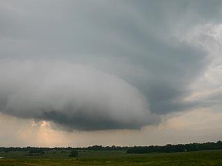
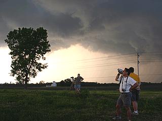
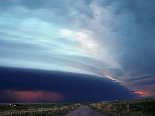
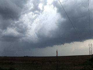
This is a picture of linear low clouds along a pre-existing surface boundary between air with different temperatures and / or wind speeds / directions. These boundaries serve as a "forcing" mechanism to initiate thunderstorms. The boundary here (view is to the west) helped trigger supercell thunderstorms near Springfield, Missouri on this chase day. |
|
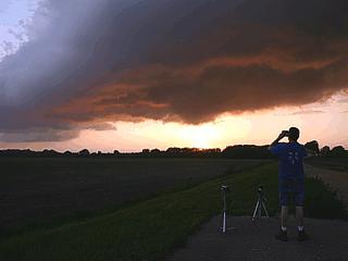
This is a view of a supercell storm at initiation phase (just developing as cap is being overcome). The view is to the south and the cell is being approached from the north. Nice rain-free base developed and note the RFD notch (clear area in the cloud base) to the lower-right. |
|
The view is now looking to the north from south of the developing supercell over Springfield, Missouri. Rock-hard and tilted convection is rooted in the boundary layer with a "beaver's tail" feature developing (lower center to lower right). |
|
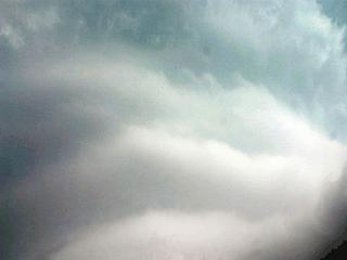
Coming around to the east side of the supercell storm. The view is to the west, and the "round" appearance of the developing mesocyclone becomes apparent in the dark cloud base. Hail up to 3/4" inch was also falling to the east and northeast of the mesocyclone. |
|
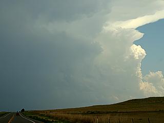
Here is a view of the supercell in classic and mature mode. The storm is small overall but rotating without a doubt. Note the striations, as well as the inflow band feature to the right. |
|
Looking nearly straight up into the vault region of the mature storm, we can see impressive striations on the updraft tower. The supercell storm is not rotating hard in the mid-levels. This is called a "barber pole" due to the stripes (striations). |
|
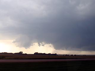
The supercell storm, in the last few pictures, instantly falls apart as the boundary it was "sitting" on moves north. Another strong to severe storm with hail developed on that same boundary and had impressive growth on its westernmost portion as seen in this picture. |
|
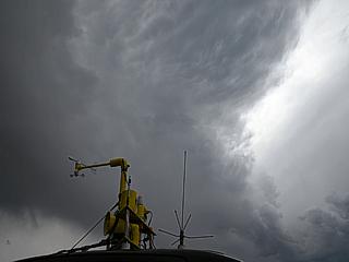
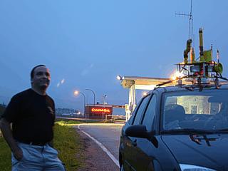
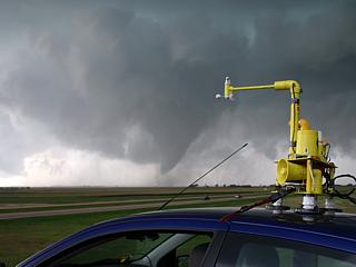
Here is a picture of my rental vehicle with the "Weatherlab" weather station mounted on the roof of the vehicle while stopped along the Colorado / Nebraska border east of Wray, Colorado on highway 34. |
|
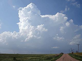
This picture shows storms initiating in the forecasted target area southeast of Wrey, Colorado. Enhanced cumulus develops and becomes towering cumulus (TCU) which precludes rapid thunderstorm development. The cap here is broken due to upslope forcing (orographics) of southeast winds in upward terrain (about 4,000 feet). |
|
This is all that became of the rapidly developing showers and thunderstorms. In this picture, a weakly rotating cloud base can be seen (an LP supercell wanna-be?) in the center of the picture with a round rain-free base. A small "RFD slot" type feature can also be seen to the lower-left side of the rain-free base. Limited moisture and weak shear caused the storm to fall apart. |
|
Looking upward, with my weather station in the foreground, a weak elevated mesocyclone produces an interesting cloud structure overhead. |
|
A shear funnel appears in a developing cumulus cloud as initiation occurs south of Interstate 90 near Chamberlain, South Dakota. These funnels aloft are caused by directional wind shear in convective clouds. |
|
Here is a picture of a group of storm chasers near Storla, South Dakota. The storms did not go supercellular, as winds aloft were parallel to the moisture axis, so an intense squall line of thunderstorms was produced. |
|
This is a picture of a strong gustnado developing along the gust front ahead of an intense squall line near Letcher, South Dakota. These are tornado like rotations that develop along opposing wind axes (in this case, strong and warm SE winds meeting cooler W winds). |
|
Here is another picture of another gustnado near Letcher, South Dakota. |
|
A bowing out line segment south of Fedora, South Dakota produces a very impressive shelf cloud along the gust front of the severe thunderstorm line. The view is to the south, and this storm had wind gusts near 70-MPH. |
|
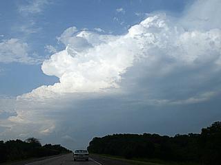
Here is a picture of convective initiation southeast of Davenport / Moline, Illinois as the cap is broken in a highly sheared environment. The cell here is on the southern end of a multicell line of storms, called a "Tail End Charley" and has the best chance to acquire supercell characteristics. |

|
A nice flanking line develops on the developing thunderstorm southeast of Moline, Illinois as chasers watch and hope the storm will continue intensifying. |
|
In this picture, about 10-15 minutes later and still southeast of Moline, Illinois, the storm slightly rotates as it becomes a small supercell storm. The weak RFD can be seen in the lower center of the picture and mild striations in the upper right. |
|
In this picture, the same storm reaches Rock Falls, Illinois, and we are now looking southward towards a split in two weak supercells. The original storm we looked at earlier near Moline is to the left and a new supercell storm is to the right. A "hole" develops between the two because one storm is moving east and the southern one is moving southeast and parting from the original storm. Large hail is to the left. |
|
The left split (original supercell) storm becomes loaded with hail making for a greenish-white color to the precipitation shaft. Note the rainbow and interesting subsidence hole punched in the supercell base. This is actually a sign the storm is becoming outflow dominant and developing a shelf cloud. |
|
Passing between the two storms, this picture is the view to the north at the intense hail core and what is left of the mesocyclone noticeable in the center-right of the picture. |
|
Here is another picture of the same storm southeast of Amboy, Illinois as it is nearly entirely outflow dominant and undercutting the southern split storm with outflow winds as storm chasers watch. The old (undercut) mesocyclone is still visible since the weak RFD notch can still be seen just to the right of the tree in the cloud base. |
|
In this picture, the storms weaken into a squall line and evolve into an MCS. All that is left ahead of the storms is a strong gust front and shelf cloud. |
|
Strong and severe thunderstorms begin to develop south of Indianapolis, Indiana in the late afternoon. The storm here is a severe thunderstorm that rapidly developed about 20 miles east of Bloomington, Indiana. The storm did not stay isolated very long, and storms eventually evolved into a multicell line. |
|
A supercell storm, prompting a tornado warning for Elletsville, Indiana, appears over wooded terrain before weakening and becoming entrained into a line of thunderstorms. Note the inflow band to the right, updraft, and if you look closely near the base of the storm, small funnel cloud near the center of the picture. |
|
Here is a picture of a strong gust front and its associated shelf cloud looking north of Spiceland, Indiana. |
|
This is a picture of the backside of the shelf cloud of severe thunderstorms near Spiceland, Indiana. The boiling appearance of the clouds (sheared by outflow air meeting air ahead of the storm system) is sometimes called the "whale's mouth". |
|
This is a picture of Kansas City (on the Missouri / Kansas border) taken from Interstate 70 on the Kansas side while on a long road trip back west anticipating more activity. This was a travel day and no storms were intercepted (actually storms way out in W Kansas and too far out of range were "missed"). |
|
Here is a picture of some interesting cloud formations (turbulent "whales mouth" type clouds) associated with a cluster of elevated strong and severe thunderstorms near Omaha, Nebraska while headed north on Interstate 29 from Kansas City, Kansas to Fargo, North Dakota. |
|
This chase day was my first time in North Dakota and beyond! In this picture, I am crossing the state line from South Dakota into North Dakota on Interstate 29 (originating in Kansas City, Kansas) making this the longest chase to this date! |
|
After a long drive north and west of Fargo, North Dakota, a releiving sight of convective initiation can be seen well to the north of Jamestown, North Dakota. This means the capping inversion has been broken, and storms have begun to develop. |
|
One updraft becomes particularly strong, as in this picture, still about 80 miles away from the storm, and acquires supercell characteristics. This supercell is the same storm that will be later intercepted in Towner County, ND northwest of Devils Lake. |
|
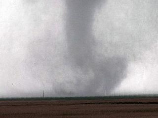
Here is a picture of the supercell storm northwest of Devils Lake, North Dakota evolving from a high-based storm to a lower-based storm (lower LCL as higher dewpoints advect towards the storm). Note the lowering developing to the right and drier air "slot" to the left. |
|
Looking north towards the developing supercell storm over Towner County (NW of Devils Lake), North Dakota, the storm takes on a "round" appearance with a developing wall cloud (far lower-left) and inflow "beavers tail" (lower-right). At this point, the storm has a mid-level mesocyclone. |
|
Here is a picture of the "business end" of the supercell storm over Towner County, North Dakota. This is a rotating wall cloud, and the feature lowering to the right is also rotating. Any funnels that formed did not touch down, but the storm was tornado warned as a strong mesocyclone was present (radar-indicated). |
|
This is a picture of the updraft-downdraft interface, or UDI, of the supercell storm just north of the mesocyclone and wall cloud. Precipitation (mostly large hail) wraps around the storm (view here is to the NW) and hail is largest just to the right in this picture. The storm here produced hail up to 3 inches (baseball sized)! |
|
Here is a time exposure picture of some vivid cloud-to-cloud lightning with the storm chase vehicle to the lower left side of the frame. |
|
How far north can you chase? Well, in this picture, this is about it ... I am standing about 100 feet from Canada! In this picture, after chasing storms in northeastern North Dakota, I decided to go an extra 20 miles to the USA / Canadian border, and take this picture of the chase vehicle and myself. Another note about this far north, the sun in late May sets extremely late, and I took this picture at about 10 PM (still cloudy, but in dusk light). |
|
Here is a picture of the first sign of severe thunderstorms from about 50 to 75 miles away. The cirrus / anvil clouds here are storms east of Rapid City, South Dakota viewed from Pierre, South Dakota. The storms to be intercepted are developing and somewhere under the clouds to the far left. The view is to the west-southwest. |
|
This is a picture of a developing supercell storm encountered near Wanblee, South Dakota. The storm is the "rotating head" on the north side of an intense bow echo segment. The chase vehicle and equipment (not wind vane with winds blowing INTO the storm) is to the lower-left. |
|
Looking southward from the supercell, a tiered shelf cloud marks the leading edge of an intense gust front associated with a bow segment where a portion of a thunderstorm cluster punches out due to an intense downdraft. |
|
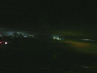
Similar shot, but without the chase vehicle and equipment, of the northern end of the bow echo with rotating HP supercell, illuminated by lightning in a dusk time-exposure. Impressive inflow bands can be seen to the lower-right. The view is west-northwest. |
|
Behind the gust front it gets too dark for normal photography since it is dusk. In this picture, a digitally processed time exposure, the eerie green glow of hail makes its appearance between the clouds. Lots of scud, and a subsidence (downdraft) hole in the cloud base (slightly left of center of image). The view is northwest. |
|
Looking southward past Wanblee, South Dakota, also in a digitally processed image, the mesocyclone (wall cloud) prompting the radar-indicated tornado warning for this storm can be seen. No confirmed tornadoes touched down but the storms produced golfball-sized hail (note the green tint). Also notice that there are no lights in town functioning (left of water tower). |
|
After being pelted with car-dinging golfball-sized hail and 70-MPH winds as the storm core passed, the hail in this picture lightens up a bit but is still nickel-sized. The supercell storm (weak mesocyclone) continued rapidly northeast. |
|
Here is a picture of one of several dust devils observed behind the cold front in warm, dry air in eastern Nebraska. |
|
Here is a view of downtown Hallam, Nebraska, a small town in southeastern Nebraska that was destroyed by a 2.5 mile-wide (yes, two and a half miles wide) tornado in May of 2004. Two years later, rebuilding of the town is underway. In this picture, two new houses appear with a concrete slab from a destroyed home in the foreground. Only a few trees remained after the tornado, and the pavement in the foreground is fresh (the tornado actually scoured some of the pavement away)! |
|
A rock-hard cumulonimbus tower pops up in northeastern Kansas along the stalled cold front. The storms here were of non-severe / marginally severe pulse type where an updraft grows rapidly then peters out quickly since upper winds are light. |
|
This is a picture of one of many small LP mini-supercell type storms forming along the dryline in southwestern Kansas. Little precipitation came out of these clouds, but note the clear "slot" in the bell-shaped base of the storm (lower center-left part of image). |
|
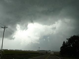
Convective initiation begins with afternoon surface heating along a stalled boundary ahead of the dryline in western Oklahoma. The storm is just developing and will soon become a supercell thunderstorm. |
|
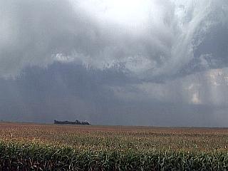
About a half hour later, the storm is now explosively developing. The view is to the south, and the anvil is blowing off with the jet stream winds from right to left. The supercell updraft and flanking line can be seen from the center of the image and to the right. |
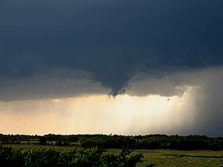
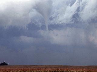
|
A small, slowly rotating funnel cloud develops in the intense rain-free base on the southwest side of the supercell in classic mode. Several funnels were produced by this storm, but none touched down. |
|
Here is a closer view of another of several funnels / rotating wall clouds produced by the supercell when in classic mode. The view is west. |
|
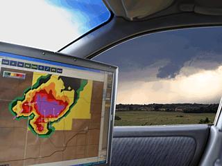
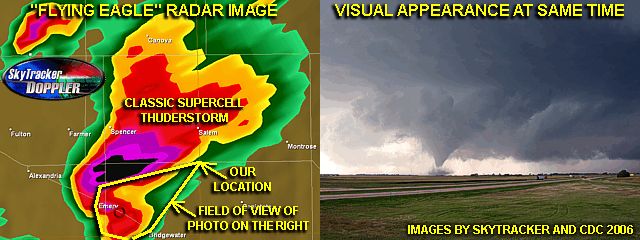
In this picture, the WX Works screen on Verne Carlson's and Tony Laubach's laptop shows a "flying eagle" type radar image, with the visual appearance of the updraft base and wall cloud out the passenger window! |
|
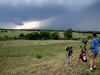
Here is another picture of chasers and their equipment documenting the superell storm as it produces a wall cloud. |
|
Here is a picture of a rotating lowering (wall cloud or large funnel) from within the so called "Bear's Cage" of the storm between the RFD and FFD regions. This is a very dangerous place to view the storm, so we did not stay in this area very long. The only way out is to go southeast and out the "opening" in the supercell notch to avoid the RFD winds to the SW and large hail in the FFD (forward flank downdraft) region to the NE! Ofcourse, the big danger is when we looked up! |
|
Here is a picture of the nearly side-ways rain / hail and violent winds as the supercell storm gusts out violently north of Interstate 40 near Highway 283. Winds here are gusting well over 75-MPH and a branch just fell from the tree in the center of the picture. |
|
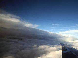
This is a picture of a line of storms associated with an MCS between Okalhoma City, OK and Dallas-Fort Worth, TX viewed from an MD-80 at about 21,000 feet on the short connecting trip between the two cities. The pilot did a great job at circumnavigating (going around) the storm cells to avoid the worst of the turbulence. The view out the window was very interesting. |
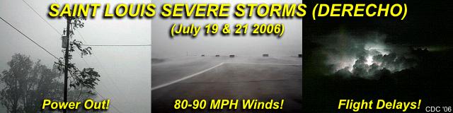
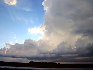
This area shows pictures taken from the infamous series of severe thunderstorms affecting the areas near and around Saint Louis, Missouri during the period from July 18 through July 21, 2006. Most notably, a major progressive derecho crossing Illinois to the southwest slammed the City of Saint Louis directly during it's journey on July 19, 2006. This became a very destructive wind storm unleashing large hail and winds up to 95-MPH, or more! Extensive damage was caused by this event alone, leaving several people dead, power out to over 500,000 people (some for over a week), and damage in the millions. Another similar storm, an HP supercell and bow-segment produced another round of 80-MPH plus winds and hail on July 21, over nearly the same areas affected 2 days prior. These two major events also produced isolated tornadoes as well. I did perform a few interceptions on these extreme severe weather events (commonly called XDW for eXtreme Damaging Wind) near Saint Louis and neighboring Illinois as well as southwestwards to the Ozark foothills. Details with pictures appear below on these events.
Such severe weather abounds during the spring, summer, and even fall in portions of the Central United States. In July and August, most severe weather occurs in the upper plains and northern Midwestern USA (such as Illinois). The week of July 18 through July 21 was no exception as some rather strong and interesting events unfolded. The first began as a bow-echo system of severe thunderstorms in SE Minnesota on July 19. This storm propagated east, then southeast, and then towards the south and southwest causing a swath of wind damage from NW Illinois then through and past Saint Louis, Missouri. Another wind and rain event occurred closer to Saint Louis on July 21, farther damaging and insulting what damage was done on July 19. These events are broken up based on chases conducted during the same week and are shown in greater detail below.
1). July 18, 7:00 PM - Interception, observation, and indirect penetration of a very severe supercell thunderstorm along Highway 21 in Reynolds County, Missouri. This was a difficult chase in the foothills of the eastern Ozark Mountains. The storm was a classic supercell storm with weak rotation developing in a northwest flow aloft type setup. The storm’s worst core was not penetrated, which contained hail to at least golf ball sized with winds to 75-MPH. The worst conditions encountered while grazing the eastern side of the supercell core were 50-MPH winds, torrential rains, frequent lightning, and hail up to 1". Tree damage was also noted with the path of this storm. This long-lived storm actually back-built to southwest and eventually produced baseball sized hail (not intercepted) in Texas County, Missouri. A large wall cloud was also noted on its rear flank (updraft was on NW side of storm). A low-pressure trough, surface heating, boundary interactions, and an upper trough caused the storms. A 2004 Ford Focus was used to chase the storm. Documentation was an HD camcorder and digital still photos. A rather small severe thunderstorm watch (issued solely for this supercell storm) was also valid for the area until 10:23 PM CDT.
2). July 19, 6:00 PM - Interception and direct penetration of a very severe thunderstorm from along Interstate 55 and 6th street near Springfield in Sangamon county, Illinois then southward just west of Interstate 55 and east of Highway 4 in rural areas until around White City in Macoupin County, Illinois. This storm was a violent multicell cluster of severe thunderstorms. The MCS developed moving eastward through southern Minnesota earlier in the day, then turned southeast, then south into Illinois, and eventually southwest into Missouri. This was the same cluster of storms that eventually caused extensive wind damage in Saint Louis, Missouri this same day. Conditions encountered with this storm included hail up to 1", winds well over 70-MPH, torrential rains, and frequent lightning with close hits. Damage to trees, power lines, and signs were observed. Power was out in many affected areas. A break developed at the southern end of this storm cluster near Macoupin County and Interstate 55 and the northern portion of the cluster weakened thereafter. A low-pressure trough, surface heating, boundary interactions, and an upper trough caused the storms. A 2004 Ford Focus was used to chase the storms. Documentation was digital still photos. A severe thunderstorm watch was also valid for the area until 9 PM CDT.
3). July 19, 8:00 PM - Interception and direct penetration of another very severe thunderstorm from near Edwardsville in Madison County, Illinois then southward along Interstates 255 and Highway 15 from East Saint Louis to Belleville, Illinois. The storm developed from a southern split in the previous cluster of severe storms farther north. The southern storm began as an HP supercell thunderstorms near Edwardsville. This supercell has a very suspicious lowering at one point in its inflow "notch" when viewed from the east (most likely a large wall cloud). The storm also had a striated "stacked plate" appearance to its low level mesocyclone. This storm quickly evolved into a bow segment multicell storm cluster and moved south and southwest. The western portions of this high-velocity bow segment devastated portions of the city of Saint Louis with winds near or exceeding 95-MPH. Conditions observed in Illinois were winds gusting over 80-MPH, torrential hurricane-like (sideways) rains, frequent lightning with close hits, and hail to 3/4". Damage to trees, signs, and power lines was extensive in some areas. Some tractor-trailer trucks were also overturned by the winds. Almost every area hit by the storms lost power. Some structural damage to buildings was also noted with the storms. A low-pressure trough, surface heating, boundary interactions, and an upper trough caused the storms. A 2004 Ford Focus was used to chase the storms. A severe thunderstorm watch was also valid for the area until 9 PM CDT.
4). July 20, 9:30 PM - Observation of a severe thunderstorm from a distance of 20-30 miles from near Highway 54 in Morgan County, Illinois. The storm was a single severe thunderstorm that developed late after a strong capping inversion weakened. The storm was not intercepted. A low-pressure trough, surface heating, and an upper trough caused the storms. Documentation was digital still photos and an HD camcorder. A 2004 Ford Focus was used to chase the storm. A severe thunderstorm watch was also valid for the area until 10 PM CDT.
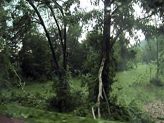
5). July 21, 11:00 AM - Interception and direct penetration of a very severe thunderstorm north of Interstate 70 and south of Highway 340 near Bridgeton in Saint Louis County, Missouri. This severe storm was another violent wind event just two days after a previous extreme damaging wind event. The storm moved in from Saint Charles County and rapidly eastwards over northern portions of Saint Louis. This storm contained winds over 80-MPH, hail up to 1", frequent lightning, and torrential rains as it was intercepted. Tree damage was heavy and many areas hit by the storm lost power. Signs and power lines were also damaged. A low-pressure trough, surface heating, boundary interactions, and an upper trough caused the storms. A 2004 Ford Focus was used to chase the storms. A severe thunderstorm watch was also valid for the area until 4 PM CDT.
This concludes the chase log for the Saint Louis / "Heat Wave" derecho sequence from July 18-21, 2006. The summary includes a total of 5 severe thunderstorms and 1 possible tornado. The main chase vehicle conducting all chases was a 2004 Ford Focus. This information was prepared exclusively for the National Weather service and the team of Skywarn storm spotters.
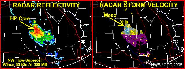
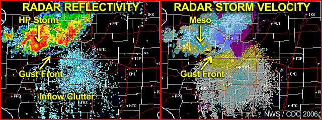
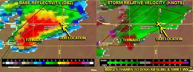
The image above is an annotated diagram showing both the reflectivity (left) and storm velocity (right) of a supercell storm about 60 miles southwest of Saint Louis over the Ozark foothills (near Reynolds County). The small but intense storm developed along a boundary with northwest winds aloft providing the directional shear necessary (note the storm oriented NW to SE). The storm was producing penny to nickel sized hail and 70 MPH winds as this image was being processed. The storm is on the limit of the WSR-88D range, that's why the "no data", depicted by magenta, appears on the lower portion of the storm. The storm eventually produced golfball-sized hail and 80-MPH winds near Reynolds County, then later, baseball-sized hail near Texas, Missouri! The storm is moving SOUTHWEST (deviant right moving) due to a motion vector between the NNW flow aloft and westward advancing boundary.
|
Here is a view of the updraft side of the developing supercell storm in Missouri. The view is to the west, and notice the updraft is on the NW side of the storm. Also visible is the tilting (or slanting) of the cumulus towers in the foreground, due to directional shear. Also note the crisp edge of the anvil to the upper-right. The core of the storm is to the left. |
|
Here is the wall cloud (with possible funnel clouds) looking south near the main updraft of the supercell. Note the "stinger" inflow cloud extending from the wall cloud (center) to the left. The green hue is caused by hail, behind the wall cloud, about golfball-sized at the time this picture was taken. Also, interesting in this picture, looking south, winds are blowing from the left to right, indicating rotation (mesocyclone). The storm rotated hard, but did not produce tornadoes. |
|
Here is some tree damage produced by the 70-80 MPH winds associated with the core of the supercell storm. The storm also knocked out power as well. |
|
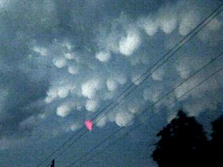
A nice display of mammatus clouds also appeared on the backside of the storm complex at dusk. |
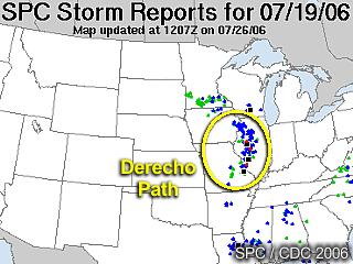
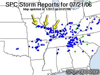
The image above is from the Storm Prediction Center's product on storm reports for July 19, 2006. What is quite interesting are the numerous reports of blue dots (wind damage) that arc from Minnesota, through Illinois, then cross St Louis into Missouri. Green dots indicate hail reports, and red ones are tornadoes (due to embedded supercells). The black square indicates where winds over 75 MPH (65 Knots) were reported. Also note the "curved" shape of the damage reports, denoting an initial SE motion, then turning south and SW later.
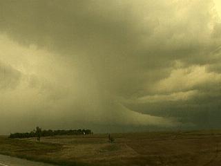
The annotated radar image above shows the bow and progressive derecho as it was blasting towards the southeast in Illinois and about 50 miles northwest of Springfield. One key feature in both the reflectivity image (left) and velocity image (right) is the radar presentation of the powerful gust front associated with this storm system. In the reflectivity image, the gust front shows ahead of the heavy precipitation cores as an arc shaped curved line. In the velocity image, yellow shades appear as inflow appear ahead of the gust front (away from the radar) as darker shades of blue appear behind it (indicating at least 60 Knots of outflow winds towards the radar)! Also note a small velocity couplet (blue next to yellow) appears on the velocity image denoting rotation in one of the intense cells in the line (embedded supercell) correlating by higher reflectivity in the image to the left. This HP supercell helped maintain the bow and derecho structure and allowed it to back-build to the south, and eventually, southwest.
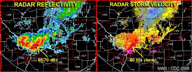
Here is an annotated diagram of both reflectivity and velocity imagery just before the storm system, and associated derecho, was about to move into the Saint Louis metropolitan area. Note that the winds in the velocity image are near 80 knots! The core of the southern and southwestern cell (maybe a "tail-end charley" HP supercell, is higher than 65 dBz, indicating large hail.
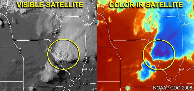
About the same time as the radar image(s) above, this is the storm complex in both visible and color-enhanced infrared channels. Note the impressive overshooting tops of the storm complex, especially on its SW side, as well as very cold (very high) cloud tops colder than -70 degrees C.

|
This is a view of the sun about 30 miles south of Springfield, Illinois while heading north in Interstate 55. The "watery" appearance is caused by the sun filtering through high cirrus and ice clouds that are blown off from thunderstorms in the rapidly approaching storm complex, which was about 50 miles away then this picture was taken. |
|
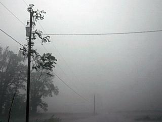
Here is a view of the intense lead gust front about 5 miles south of Springfield, Illinois while headed north on Interstate 55. The gust front had winds gusting well over 70-MPH at this point. |
|
Here is another view, looking out from inside the storm, of the intense lead gust front while headed south on Interstate 55 out of Springfield, Illinois. 70-MPH plus winds associated with this gust front preceded the arrival of rain and hail. Note the dust getting kicked up. |
|
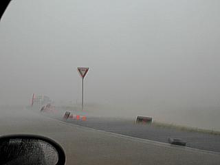
Visibility drops to near zero in ferocious 80-MPH winds and hail mid way between Springfield, Illinois and St Louis, Missouri just west of Interstate 55. |
|
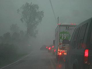
Here is another picture, taken in the northern portions of St Louis, Missouri, of a line of cars trapped as trees and powerlines fall on the road. Note the car turning around at the head of the traffic jam. Winds gusted to near 100-MPH in this portion of the storm system. |
The annotated SPC storm reports product above clearly shows the path of wind damage (blue dots) extending from just NW of St Louis, Missouri to southern Illinois. This storm system began as a bow-segment with an embedded HP supercell (mesocyclone). The HP storm strengthened within this line, and produced another round of winds over 80-MPH (denoted by black squares, one right over St Louis). An additional 250,000 people lost power from this storm system in St Louis alone, in the SAME areas affected by the derecho event 2 days prior. Note the tornado report (red dot) in Illinois as the HP supercell did spawn a tornado as well.
|
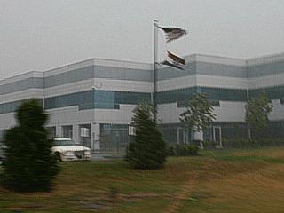
The HP storm arrives at about 11 AM in the NW suberbs of St Louis (near St Charles) with 60-70 MPH winds. In this picture, flags are being blown by the strong winds. |
|
The storm continues to intensify as it moves eastward at nearly 50-MPH. Winds easily gusted over 80-MPH with hail to golfball sized. In this picture, a large tree branch became airborn and came to rest in a power pole. |
|
Strong winds and hail whip sideways as in a hurricane. Many road signs and construction equipment was blown over. |
|
In this picture, you can see the sheets of rain blasting across the roadway at well over 70-MPH. The objects in the background are construction signs that were also blown over. |
|
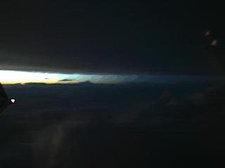
The storms caused extensive flight delays, and I myself became affected as I had to fly home to FL on the evening of July 21. A two hour delay, due to weather, caused me to miss my connection in Atlanta, causing another 8 hour delay and frustration. From the air, once above the low clouds and out of St Louis, the flight path had to cross the same complex of storms that passed through St Louis earlier. In this picture, the canopy of anvil clouds can be seen barely visible by the setting sun at about 25,000 feet. The active thunderstorm cells themselves are to the far right in the picture. |
|
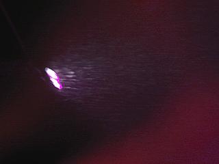
While flying through and around the complex of storms, somewhere over Kentucky / Illinois, snowflakes become visible - Illuminated by the wing-tip strobes and anti-collision lights. Lightning was all around us too and made for a very bumpy ride. |
|
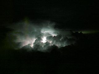
Here is a picture, illuminated by lightning, of a descrete thunderstorm cell where the cumulus structure is revealed. This was just after getting past the worst of the storms, at 33,000 feet somewhere over Tennessee. |
|
Now farther away from the line of severe thunderstorms, and beginning our descent into Atlanta, lightning illuminates the active cells in the line like a "string of pearls". The yellow "glow" in the clouds to the right is from the lights of Atlanta, Georgia. |
| CHASER NAME | HOME CITY | CALLSIGN | CHASE DATES | OCCUPATION |
| CHRIS COLLURA | MIRAMAR, FL | KG4PJN | 9-15 TO 9-17 | IT CONSULTANT |
The participants below are not from the "Sky-Chaser" chase team. These people often actively participate in my storm research and documentation efforts and deserve appreciation for their great help and severe weather expertise.
| CHASER NAME | HOME CITY | CALLSIGN | OCCUPATION |
| DOUG KIESLING | MINNEAPOLIS, MN | N/A | PHOTOGRAPHER |
| TONY LAUBACH | LITTLETON, CO | KC0ONL | STUDENT |
| VERNE CARLSON | DENVER, CO | KB0ZCQ | IT |
September 15 - This was a travel day for the rather short and "convenient" chase trip as it was on a Friday and the entire weekend was available for chasing. The chase trip began after leaving work on Friday at about 4 PM, which is a 6-month computer programing contract in Creve Coeur, Missouri. My own vehicle, a 2006 Ford Focus, was packed and used for this entire chase. I left the western Suberb of Saint Louis, MO and headed west on I-70 towards Kansas City, MO. The night was also spent here, and upon forecasting, the target area was anticipated to be anywhere from Omaha, Ne northward to Sioux Falls, SD with Sioux City, Iowa being in it's midpoint. Interstate 29 was going to be the most important northward "corridor" for the start of the actual chase.
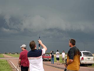
September 16 - Today was an incredible chase day to say the least, with the simple words "dream chase" a good description. Left Kansas City, MO early after looking at data and decided on a preliminary target of Siuox City, Iowa. A powerful low pressure area was setting up in southern portions of central / western SD and backing winds were forecasted to increase in the target area along with a moisture axis of higher dewpoints (mid 60's). Shear was the big player in this case, with the left exit region of a 120 knot+ H3 (300 MB) jet stream nosing in to the target area below which had veering winds with helicities around 500 and a forecast CAPE of 3,000 alread being hinted by soundings in the area. The trip began north on I-29 through Omaha where I got breakfast and then caught up with Verne Carlson and his son chasing just north of town. We continued north on I-29 into Sioux City, Iowa where we looked at more data. It soon became clear that the best area was a bit farther north, near Sioux Falls, SD and I preached we head up that way. A weak boundary was also oriented W to E with a temperature change of about 5 degrees (cooler at 84 F near Sioux Falls, SD) as well as a dryline bulge nudging in from it's southwest. The first cumulus was noted NW of I-29 when about 40 miles south of Sioux Falls, SD and quickly became enhanced / towering. In Sioux City, we headed west on I-90 to intercept the RAPIDLY developing storm, which had a rock-hard anvil and was already severe (then tornado) warned only 45 minutes after initiation. Verne and I made it to the I-90 and Highway 81 overpass where we stopped to observe the rapidly developing wall cloud on the base of the now supercellular storm. This quickly became tornadic and produced a large tornado which eventually crossed this intersection. We moved east, then northeast as the first tornado, which lasted 15-20 minutes weakened. I continued with the storm north on Highway 19 then east on county road G where a second tornado, lasting about 2 minutes developed and destroyed a house. Verne and I separated at this point, but I met back up with him, and Tony Laubach near Trent, SD on CR G shortly after. We continued east towards Pipestone, MN where a third funnel 1/2 way to the ground was observed (possible 3rd tornado). The storm continued northeast and weakened at that point. We headed back west towards I-29 to intercept a second supercell storm near Brookings, SD but got there a bit late when the storm was at its severe (bowed segment) stage. We wrapped up the chase and headed back to Sioux City, Iowa for dinner and spent the evening there.
September 17 - Today was a travel day and included the long drive back from Sioux city, Iowa back down I-29 then east through Kansas City, MO on I-70 to Saint Louis, MO. Arrived back at my apartment in Creve Cour, MO by 4:30 PM on Sunday and began updating data and pictures. Total mileage from Friday was 1,451 miles.
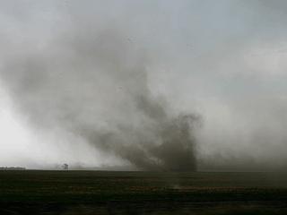
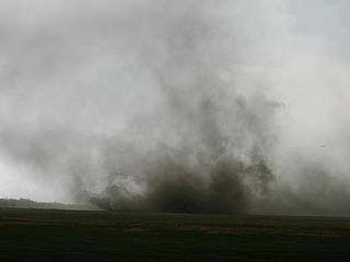
1). September 16, 4:00 PM - Interception and observation of an extremely severe and tornadic supercell thunderstorm from near Interstate 90 and Highway 81 in McCook County, South Dakota (west of Sioux Falls) northeastward through Pipestone, Minnesota. The storm was a cyclic classic supercell thunderstorm and produced two (or even possible 3) tornadoes. The first tornado developed southwest of the intersection of Interstate 90 and Highway 81. The tornado began as a cone tornado, crossed over I-90 at the overpass of Highway 81 (the overpass took a direct hit with the core windflow of this tornado), evolved into a large (1/4 mile wide) stove-pipe tornado, then roped-out about 1 mile north of I-90 near Montrose. The tornado was on the ground for about 20 minutes and came within 1/2 mile of our observation point. Debris was noted falling from the sky and a loud "roar" heard from the tornado during it's stove-pipe phase. The Rear Flank Downdraft also hit at the same time with heavy rain, small hail, and winds gusting to 70-MPH from the west. The storm produced a second tornado, near Highway 19 and and county road G that lasted about 2 minutes and destroyed a house. The storm continued northeast towards Pipestone across the border into Minnesota. A third funnel (a thin rope half way to the ground) was noted and could have possibly been a 3rd tornado. This one lasted only about 30 seconds. The storm continued northeast of Pipestone, MN and weakened. Other conditions encountered with this storm were occasional lightning, small hail, heavy rains, and winds near 70-MPH. The main hail core (at least golfball sized) was not intercepted. Damage observed was an overturned truck on I-90, tree debris blown around, and major structural damage to a farm house near Chester, SD. Conditions causing the storms were a surface boundary / dry-line interaction, surface heating, and a low pressure system in a strongly sheared (directional shear) environment / very strong winds aloft. A 2006 Ford Focus was used to chase the storms. Documentation was still digital photos and HD video. A tornado watch was also in effect for this area until 10 PM CDT.
2). September 16, 6:30 PM - Observation and penetration of another severe thunderstorm near Flandreu, MN along Highway 34. This storm was a smaller HP supercell thunderstorm which did not produce a tornado but had a fairly large wall cloud, RFD clear area, and shelf cloud. The storm was penetrated and contained very heavy rains, 40-MPH winds, and small hail on its southern side. The storm weakened north of Pipestone, MN. Conditions causing the storms were surface boundaries, dry-line, surface heating, jet stream aloft, and a low pressure system. A 2006 Ford Focus was used to chase the storms. Documentation was still digital photos and HD video. A tornado watch was also in effect for this area until 10 PM CDT.
3). September 16, 7:30 PM - Observation of a severe thunderstorm northwest of Brookings, SD to the west of and along Interstate 29. This storm was formerly a tornado-producing supercell storm that evolved into a bow-echo / MCS structure upon our arrival to it. This storm had a linear, but spectacular appearance to it. A large shelf cloud and hail streaks were noted at about 10 miles from the storm. Part of this storm was penetrated and contained very heavy rains, 35-MPH winds, and small hail during its weakening phase. Conditions causing the storms were surface boundaries, dry-line, surface heating, jet stream aloft, and a low pressure system. A 2006 Ford Focus was used to chase the storms. Documentation was still digital photos and HD video. A tornado watch was also in effect for this area until 10 PM CDT.
This concludes the Chase Log for the South Dakota tornado chase trip in September 2006. The summary includes a total of 3 severe thunderstorms, one of which produced 2 major tornadoes and at least one additional funnel (possible tornado). The main chase vehicle conducting all chases was a 2006 Ford Focus. This information was prepared exclusively for the National Weather service and the team of Skywarn storm spotters.
|
This is a picture of a horseshoe type "shear" funnel / vortex that deveops in convective clouds in an environment of high wind shear. There are actually two in this picture, to the lower-right. This was a complex of elevated cumulus associated with the very beginning of the weather system that would cause so much severe weather later on in the day. These fairly innocent, but highly sheared, cumulus developed northwest of Kansas City near Saint Joseph, Missouri and Interstate 29 during the morning of September 16, 2006. |
|
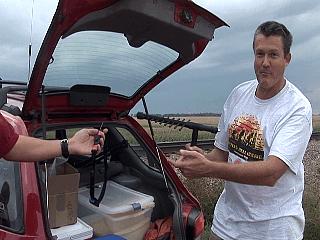
Here is a picture of my vehicle, foreground, just after mounting the weather station "weatherlab" equipment on the roof and meeting up with Verne Carlson and his son (red car to the left in background). We are in Sioux City, Iowa looking at data and just about to make the crucial decision to head north into southeastern South Dakota. |
|
Looking northwest, and about 40 miles away (we are about 40 miles south of Sioux Falls, SD and headed north on I-29), towering cumulus wells up above the agitated cumulus in the foreground. This is called convective initiation and was the first sign of convection. This puffy cloud is the SAME CLOUD that will EXPLOSIVELY develop into the raging supercell you will see in the upcoming pictures. Time here is roughly 3:15 PM CDT. The chase is on! |
|
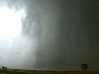
This is a picture looking west on Interstate 90 about 5 miles west of Sioux Falls, SD at the developing storm about 40 minutes later (roughly 3:45 PM CDT). We have already rounded the metro area of Sioux Falls off I-29 and made it west on I-90. The storm is already severe and tornado warned on rarar (radar indicated). The base of the storm is still too far away, but the rock-hard anvil edge can be seen overhead in the upper left part of the picture. |
|
Here is another view of the well-defined anvil spreading overhead (view is high and to the southwest). The storm now is a fully developed supercell and we are still headed west on I-90 towards its southwestern (rear-flank) region. Time is about 3:55 PM CDT. |
|
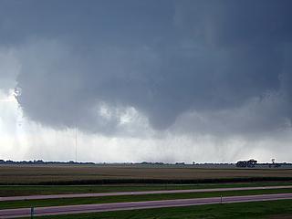
The wall cloud of the storm's southwestern flank becomes visible and begins rotating very vigorously. We are just east of Highway 81 on Interstate 90 and the time is 4:05 PM CDT. We decide to get off at the next exit as I announce on the HAM that tornado-genesis is occurring. Note the developing funnel on the lower-right side of the picture just right of the wall cloud. The timing of this chase COULD NOT have been any BETTER! |
|
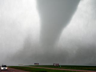
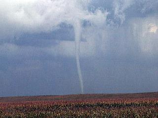
Large tornado rapidly developing just west of Bridgewater in Mc Cook County, SD and about 5 miles southwest of us! Time is 4:08 PM CDT and we are on the north side of the overpass of Highway 81 and Interstate 90. The visible funnel in this picture is not in contact with the ground, but dust and debris swirling around under it confirms the tornado touchdown. Remember, LESS than an hour ago, this storm was just an "innocent" looking puffy cumulus cloud! |
|
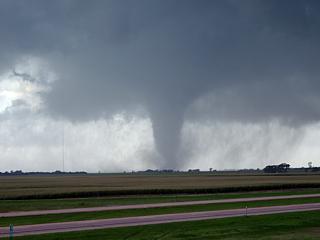
Large tornado now fully developed and on the ground southwest of our location. This is coming directly at us, and this overpass we are on will soon sustain a direct hit by the core of this tornado about 10 minutes after this picture was taken. Many locals asked us if they were safe there. I just told them "No! Turn around and go back to Sioux Falls, Now! This tornado WILL cross this highway!" - Fortunately, they all listened. |
|
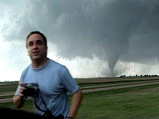
Here is another picture of the tornado and my chase vehicle (with the Florida plates) in the foreground. At this point, I was taking as many still pictures and filming HD video at the same time. Many pictures I took with the tornado and chasers, vehicles, and equipment in the foeground. |
|
Here is a picture of myself with my digital camera and the mature cone tornado in the background approaching us at the rate of one mile every two minutes. Its now 4:12 PM CDT, and the tornado is about 4 minutes from hitting the overpass. |
|
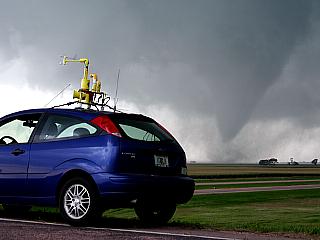
Large tornado is roughly 2 miles southwest of our position, so its time to relocate farther east. I take one last picture of the weather station on the top of my vehicle and the approaching twister. Note the wind vane on the "weatherlab" station showing inflow winds going right into the storm! |
|
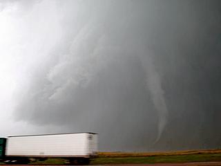
Closeup of "corner region" of tornado at distance of less than 2 miles. Fortunately, this tornado missed Bridgewater and remained over open country until crossing Interstate 90. |
|
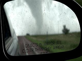
This is a shot I always wanted to get with a tornado and not having to do any "special effects"! The tornado was really "closer than it appeared" as the same overpass (highway 81 over I-90) where last several pictures were taken took a direct hit from the tornado. The storm is about a mile and a half behind us. Time is roughly 4:15 PM CDT. We are headed down the road (East) on I-90 to get back into a safe position to continue documenting the tornado. Verne Carlson is leading the way in his vehicle. |
|
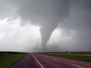
The tornado has just struck the overpass of Highway 81 and I-90 dead on and is moving to the east and northeast. Time is 4:17 Pm CDT and the tornado is reaching peak width and intensity. |
|
Here is a closer view of the lower portion of the tornado which is now just north of Interstate 90. At this point, a load "roaring" or "train" sound can be heard. Light tree and plant debris starts to "rain" down at our location. Tornado is about 1 miles northwest of us. |
|
The tornado reaches its widest point and strongest intensity at over a quarter-mile wide (about 2,000 feet across). The tornado is now a mature stove-pipe and is about one-half a mile north of us on I-90. Note the small debris in the air. The RFD is approaching and winds suddenly blast at 70-MPH from the west as the light shining through the RFD clear-slot illuminates the back side of the stove-pipe tornado. |
|
Rear flank downdraft (RFD) continues from the west at 60-65 MPH and tornado begins occlusion cycle, morphing from a stove-pipe to a narrower cigar-shape. The white precipitation is hail in the RFD "blob" and downdraft. |
|
The weakening phase of the tornado like this is usually the "rope" phase. The tornado is still powerful and extremely dangerous (fortunately it is still over open fields). The narrow, twisting funnel resembles a whitish "rope". Time is about 4:22 PM CDT. |
|
This is a picture showing the beautiful but deadly structure of the tornado rope-stage, still fully condensed. About a minute later, the visible funnel vanished and tornado number one oficially is gone by 4:25 PM CDT. The RFD still pushes outward and is loaded with rain, strong winds, and hail. |
|
The supercell storm that produced the tornado is called a CYCLIC supercell, because when the first mesocyclone weakens, another forms and re-strengthens. A second intense area of rotation is developing just north of the "clear slot" (bright area) marked by the RFD looking north. This is highway 19 and approaching Chester, SD. Time is roughly 4:45 PM. |
|
The RFD region is penetrated with strong winds, rain, and small hail. North of the rain hook, a rapidly spinning region of clouds called a tornado-cyclone is forming. This is where a low-level mesocyclone "tightens" up, like an ice skater pulling her arms in and spinning faster. This is tornado genesis cycle 2 of the supercell beginning. |
|
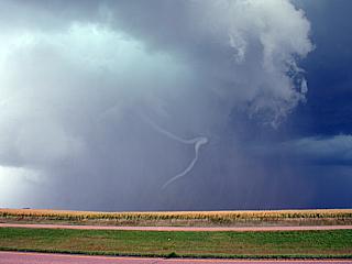
A narrow funnel develops right in the center of the now violently spinning clouds. The funnel extends quickly earthwards at about 4:51 PM CDT. |
|
Tornado number two from the same storm quickly develops and fully condenses to the ground. This narrow "elephant trunk" type twister is white because the light is from behind me and tyhe view is looking east. Time is 4:22 OM CDT and this is about 3 miles south of Chester, SD near Highway 19 and county road G in Minnehaha County. |
|
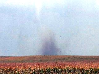
Unfortunately, this short-lived tornado strikes a farm house and it is destroyed instantly. Other chasers on this storm have closer shots, showing the house simply exploding and / or disintegrating. The large "pieces" in the air near the dark debris cloud in this picture are large remnants of the house. No one was in the house that was destroyed. The tornado quickly dissapated afterwards at about 4:24 PM CDT. |
|
The cyclic storm is followed northeast for an additional 50 miles until about 6:00 PM where is continued to produce several small funnels (or even a third tornado). In this picture, the storm weakens into a more linear / bow shape northeast of Pipestone, Minnesota. Unfortunately, the storm did not completely dissapate, as it continued towards the southwestern suburbs of Minneapolis / Saint Paul causing one death and damaging 200 homes later that evening. |
|
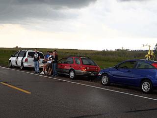
This is a picture along the side of the road near Pipestone, Minnesota. Verne Carlson and myself met up with Tony Laubach and a few others with him who arrived a bit late for the first storm (they came all the way from Denver, Colorado)! Tony's van he calls "white lightning" is to the left. |
|
Waiting for some more supercell storms to develop and move towards us, Verne and I get a chance to show Tony Laubach and his crew some tornado footage we shot earlier! |
|
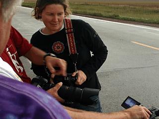
Here is Verne Carlson, right, showing off his tornado video probe. It is so funny as he is wondering to this day why he did not "deploy" this earlier on the I-90 / Highway 18 overpass - Adrenaline makes you think otherwise. The way it works is in two parts. The person on the left is holding a strap, containing a hardened case holding a battery, video camera, and transmitter. To the right is the Yagi antenna used to receive the near-microwave signal from the video device. The goal is to strap this device to a pole or guardrail in the path of a tornado, back away to a safe distance, and receive the video via the Yagi antenna and receiver. |
|
Another small non-tornadic supercell comes up near Flandreu, MN near Highway 34. This storm did not last long, but produced this beautiful wall cloud that quickly evolved to an outflowish type shelf cloud when its RFD occluded. |
|
Looking north, here is a view of the RFD clear-slot (although loaded with rain), on the southern side of the mini HP supercell near Flandreu, MN. The storm quickly weakened shortly after by about 6:45 PM CDT. |
|
Another tornado was reported at about 6:55 PM CDT on a storm west of Brookings, SD, so we decided to head for it as it was the last storm of the daylight hours. We headed up I-29 but arrived at the storm northwest of Brookings at about 7:30 PM CDT. By this time, the supercell storm evolved into a bow-echo type MCS that was outflow dominant. The southern cells on this storm system were very beautiful as they were back-lit tranclucently by the setting sun. |
|
Here is a view of the remnants of the mesocyclone of this storm, which is now mostly a linear / bow shaped MCS. The inflow portion of the wall cloud is still intact and can be seen extending from right to left into the storm (lower right portion of this picture). A slight RFD push can be seen to the left. The mesocyclone, if any, is located in the center of the picture just above the horizon. The setting sun reflecting off hail makes the clouds appear an errie green color. |
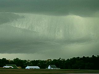
|
A hail shaft of possibly golfball sized hail descends through a portion of the cloud base of the severe thunderstorm and causes an interesting "streaking" in the clouds. These are called "hail streaks" and can easily be seen in the upper-center this picture. |
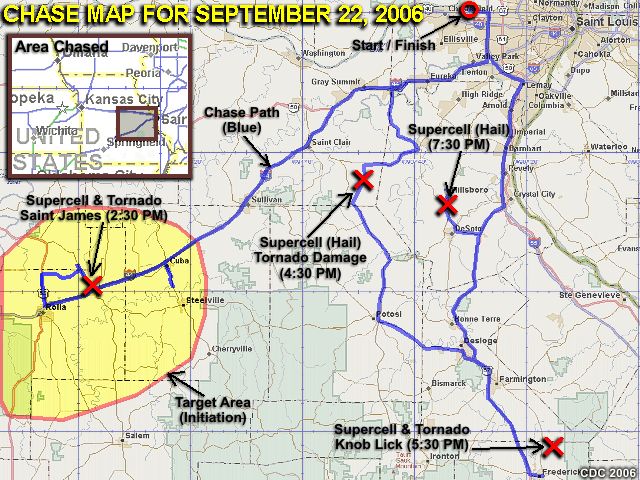
| CHASER NAME | HOME CITY | CALLSIGN | CHASE DATES | OCCUPATION |
| CHRIS COLLURA | MIRAMAR, FL | KG4PJN | 9-22 | IT CONSULTANT |
September 22 - Today was a very interesting chase day as I was solo and chasing in my temporary "home" state of Missouri. Left Saint Louis around noon and headed to the southwest along Interstate 44. A developing low pressure area was setting up in eastern portions of Oklahoma / Kansas and backing winds were forecasted to increase in the target area, which was near Rolla, Missouri, along with a warm front, weak dryline bulge to the west, and moisture axis of high dewpoints (lower 70's). Shear was also a big factor in this case, with windfields from 850 MB all the way up to 250 MB extremely powerful, all increasing and veering with height (SSE at surface, SW at 850 MB, W at jet stream level). The core of the jet stream, starting with the exit region at well over 125 knots (at 300 MB) was already in place. Helicities were at least 500 with a forecast CAPE of 2,000.
The trip began heading southwest on I-44 to the primary target area near Rolla, MO. When stopping in Rolla and checking radar, supercells were already developing as I arrived right at the moment of initiation. This storm quickly became a supercell near Vichy, MO and developed a "flying eagle" signature on the radar image. I continued north for intercept on highway 63, and got a great view of the storm, with continuous CG lightning, a nice wall cloud, and striations on its updraft. To stay ahead of this storm, I needed to take some back roads to catch up with Highway 68 to my east, then headed southeast. The storm produced a destructive tornado which passed just 1/4 mile to my south of my position on Highway 68. Debris was noted about a thousand feet in the air, powerlines sparked, and sure enough, the grim damage path was encountered a few minutes later on the north side of Saint James, MO. The tornado was followed along I-44 out of Saint James to Cuba, MO, then farther northeast until it dissapated. The tornado lasted about 14 minutes (starting at 2:35 PM CDT).
Another supercell thunderstorm was encountered in Jefferson County east of Lonedell, Missouri near Highways 30 and 47 at about 4:30 PM. The core of this storm was encountered with golfball hail, and major damage was noted to a ranch while headed south and behind the supercell on Highway 47. This was tornado damage, but the tornado was not observed. A third supercell was encountered in Saint Francios county east of Knob Lick while headed south on Highway 67 at about 5:30 PM. This storm was observed from the backside, but a funnel / possible tornado was noted on its rear flank from about 10 miles away. This storm did produce a large wedge tornado as it crossed into Illinois later (the wedge was not observed). Finally, a fourth supercell storm was encountered near Hillsboro, Missouri along Highway 21 with incredible shelf-cloud structure, strong winds, and large hail around 7:30 PM. I wrapped up the chase and headed back north along Highway 67, then Interstate 270 to western Saint Louis (Creve Coeur) for dinner and returned to my apartment by 9:30 PM.
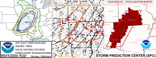
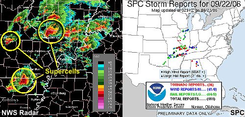
1). September 22, 2:30 PM - Interception and observation of an extremely severe and tornadic supercell thunderstorm from north of Interstate 44 from Vichy, Missouri in Phelps County near Highway 63 then through Saint James along Highway 68. The storm was a classic supercell thunderstorm and produced a destructive tornado that struck the northern portions of Saint James, Missouri with severe damage (especially to a gas station) near I-44 and Highway 68. The tornado was noted as a field of airborne debris under a rapidly rotating cloud base on the SW side of the supercell. The tornado was on the ground for about 15 minutes and passed only 1/4 mile south of my observation point! The tornado was at least 1/4 of a mile wide (about 1,500 yards) causing high-end F1 damage. The storm was followed to the northeast along Interstate 44 through Cuba, Missouri. Trucks were overturned on Interstate 44. The supercell storm and its associated tornado continued east and northeast. Other conditions encountered with this storm were very strong winds (over 70-MPH), mainly with the rear-flank downdraft (RFD), small hail, frequent lightning, and torrential rains. The main hail core (up to baseball sized) was not intercepted. Damage observed was severe structural damage to at least one gas station, car wash, debris (building and tree) strewn across the side of Highway 68, power knocked out, and an overturned truck on I-44. Conditions causing the storms were a surface boundary (warm front) and diffuse dry-line interaction, surface heating, and a low pressure system in a strongly sheared (directional shear) environment, and very strong winds (jet stream) aloft. A 2006 Ford Focus was used to chase the storms. Documentation was still digital photos and HD video. A tornado watch (PDS for "Particularly Dangerous Situation") was also in effect for this area until 9 PM CDT.
2). September 22, 4:30 PM - Interception and penetration of another extremely severe and tornadic supercell thunderstorm in Jefferson County near Lonedell, Missouri along and near Highways 30 and 47. The storm was another classic supercell thunderstorm and produced a tornado which caused damage in the same county. The tornado was not directly observed but the core of the storm was penetrated where very strong winds (over 65-MPH), frequent lightning, torrential rains, and hail up to golfball sized were encountered. A large wall cloud was noticed on the southwest side of this storm, but no rotation was noted. A damage path, however, was encountered behind this storm, that was undoubtedly tornadic in nature. A ranch and house on it was heavily damaged in this path. Conditions causing the storms were surface boundaries, surface heating, and a low pressure system in a strongly sheared (directional shear) environment, and very strong winds (jet stream) aloft. A 2006 Ford Focus was used to chase the storms. Documentation was still digital photos and HD video. A tornado watch (PDS for "Particularly Dangerous Situation") was also in effect for this area until 9 PM CDT.
3). September 22, 5:30 PM - Interception and observation of another extremely severe and tornadic supercell thunderstorm in Saint Francios County near Knob Lick, Missouri east of Highway 67. The storm was another supercell thunderstorm that moved across and near Pilot Knob and Ironton, and affected extreme northern Madison County. This storm was not penetrated (although its core had at least golfball, or larger hail). The fast-moving storm was viewed from its western to southwestern side, where a large RFD slot and funnel (possibly a tornado) was observed. This is the SAME storm that continued to the east and produced a wedge tornado across the river near Carbondale, Illinois. Conditions causing the storms were surface boundaries, surface heating, and a low pressure system in a strongly sheared (directional shear) environment, and very strong winds (jet stream) aloft. A 2006 Ford Focus was used to chase the storms. Documentation was still digital photos and HD video. A tornado watch (PDS for "Particularly Dangerous Situation") was also in effect for this area until 9 PM CDT.
4). September 22, 7:30 PM - Interception and penetration of a very severe supercell thunderstorm near Hillsboro, Missouri near Highway 21. The storm was an HP type supercell thunderstorm. The storm had rotation in the mid levels and had the impressive "stacked plates" appearance to its rear-flank shelf cloud. When the storm became more outflow dominant, the core of the storm was penetrated. Strong winds gusting near 60-MPH, frequent lightning, torrential rains, and hail up to quarter-sized was encountered briefly in this storm. This storm did have a history of wind damage and power outages. Conditions causing the storms were surface boundaries, surface heating, and a low pressure system in a strongly sheared (directional shear) environment, and very strong winds (jet stream) aloft. A 2006 Ford Focus was used to chase the storms. Documentation was still digital photos and HD video. A tornado watch (PDS for "Particularly Dangerous Situation") was also in effect for this area until 9 PM CDT.
This concludes the Chase Log for the Missouri short tornado chase trip in September 2006. The summary includes a total of 4 severe thunderstorms, three of which produced tornadoes. Out of these three tornadoes, two were observed (including the damaging tornado in Saint James, MO), and the third the damage path being encountered. The main chase vehicle conducting all chases was a 2006 Ford Focus. This information was prepared exclusively for the National Weather service and the team of Skywarn storm spotters.
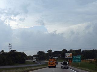
|
Convective initiation promptly begins one the target area of Rolla, Missouri is reached. In this picture, looking west on Interstate 44, a rapidly developing supercell storm is in the making. The main updraft is barely visible to the right, but a rock-hard anvil can be seen overhead in the distance (extends to the upper-left). |
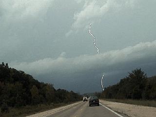
|
A barrage of cloud-to-ground (CG) lightning increases in intensity on the northeastern side of the developing supercell storm. The view here is to the north from 4 miles north of Rolla, MO along Highway 63. Note the band of clouds marking the forward-flank boundary. |
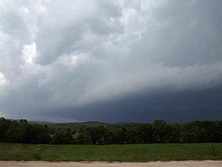
|
Looking west of Highway 63, an impressive updraft base is developing with a nice rear-flank shelf cloud on the southwest side of the supercell. The storm is southeast of Vichy, Missouri. Note the rounded shape of the storm base and main flanking line feeding into it from the far lower-left. |
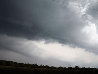
|
Here is a picture of the northeastern (forward flank) side of the supercell, which is now about 10 miles or so west of Saint James, Missouri. Incredible inflow "feeder band" type clouds indicate a well-developed inflow into the rapidly intensifying storm. The view here is to the north, and the cloud bands are moving rapidly from right to left. |
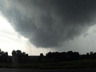
|
This is a picture looking southwest from about 2-3 miles northwest of Saint James, Missouri while stopped on Highway 68. The entire "bowl shaped" lowering is rapidly rotating during tornado-genesis. This tornado, however, did not have a very visible funnel, until debris was picked up by the circulation. The "dusty material" which looks like precipitation just under and to the left of the lowering's bottom is NOT rain, but debris being lifted into the air. |
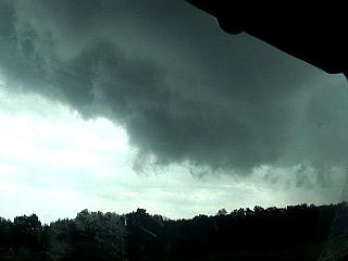
|
Here is another view of the developing tornado. The lowering is rapidly rotating and has developed a visible funnel on its northern side (to the right in this picture). This tornado now is about 2 minutes away from hitting the northern portion of Saint James. |
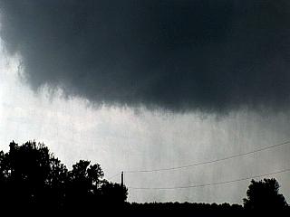
|
This is a picture of the closeup under the rotation. Small swirls of debris is visible under the violently rotating clouds. Any rain is "tagging", where rain in the foreground is moving left to right, and rain in the background is moving right to left (tornado circulation). Still no visible "funnel" touching the ground, but debris confirms a full-fledged tornado is ocurring. It is just entering the northern portions of Saint James in this picture. |
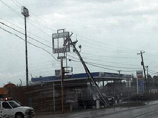
|
After waiting for the 1/4 mile wide tornado to pass merely 1/4 mile south of me, with a loud bang as a pole transformer explodes, I cautiously continued south on Highway 68 into Saint James. The power pole is destroyed to the left, and the tall sign is damaged. This is just north of Interstate 44 along Highway 68. |
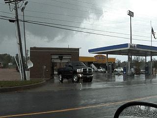
|
This is a picture of some damage to a gas station along Highway 68 in Saint James, Missouri just north of Interstate 44. If you look at the convenience store in the center of the picture, you can see it is severely damaged. By the way ... Look above the pickup truck and damaged carwash to the upper-left and you can see the tornado moving off to the east and northeast! |
|
Here is a picture of an unfortunate person and his car across the street in Saint James who was caught off-guard when the tornado hit. The man is OK but his car was damaged as a gas pump blew over and fell right ontop of it as he was getting gas. Note that the canopy of the gas station is also tilted a bit. This is typical strong-F1 damage, where winds can be from 72 to 112 MPH. |
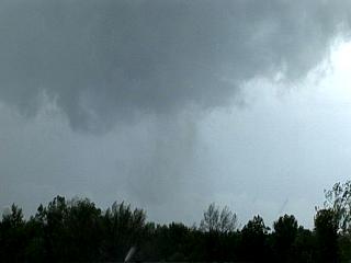
|
Here is another picture of the tornado moving away to the east and northeast after crossing Interstate 44. The tornado is between Saint James and Cuba, Missouri and is moving to the northeast at over 45 MPH. This view was taken looking to the east-northeast from the I-44 and Highway 68 overpass in Saint James. Note the "tube" of dust and debris being lofted into the tornado. At this point, a packing plant was being heavily damaged. |
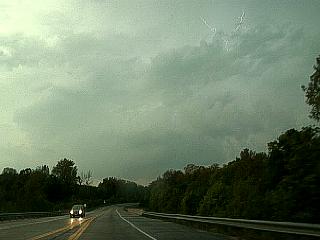
|
Another supercell storm develops near Lonedell, Missouri well south of I-44 and near Highways 30 and 47. This storm is to my west in this picture, and an anvil can be seen spreading overhead with cloud-to-cloud (CC) lightning in the anvil to the upper-right in this picture. |
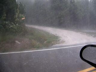
|
The core of the supercell near Lonedell is penetrated along highway 47 in an attempt to get to the rear flank of the storm. This is called "core punching" and is not recommended unless you know what you are doing. In this picture, 65-MPH winds, or higher, are blowing across the road with hail up to golfball-sized. The white "streaks" to the left are bouncing hail stones. Meanwhile, about 5 miles to my southwest, a ranch is being destroyed by another tornado. |
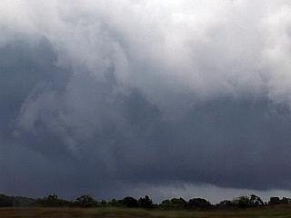
|
This is a picture looking east to a supercell thunderstorm that crossed north of Madison County causing more tonrado damage. These storms are moving very fast, so if you are behind one, you will NOT catch up with it anymore. In this picture, a large funnel can be seen on the rear-flank (view is to the east) of the supercell updraft, and is quite possibly another tornado. This cyclic supercell storm had a history of tornadoes, one of which was nearly a mile wide after this picture was taken and the storm crossed into Illinois near Carbondale. |
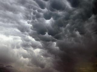
|
Beautiful mammatus clouds float high overhead as more storms develop to the west and their anvils are blown over by the intense jet-stream winds aloft. These cloud formations also denote severe (or greater) turbulence aviation-wise. |
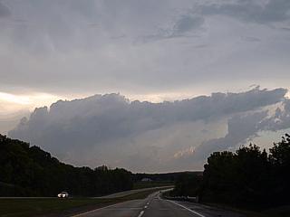
|
This is a picture looking to the north at some smaller cumulus "turkey tower" type clouds. Note that these clouds are smaller since they are well below the anvil of the storms to my west. What is trying to be shown here is the incredible amount of speed and directional wind SHEAR. The cumulus clouds "try" to grow vertically but are instantly toppled over from left to right because the winds increase and change direction as you go higher up in the atmosphere. |
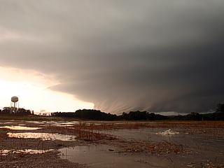
|
Another supercell storm develops west of Hillsboro, Missouri just before dusk and trudges rapidly to the east and northeast. In this picture, looking west and southwest, the ominous and striated rear-flank shelf cloud looms over the horizon. |
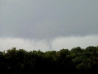
|
Interesting lowering under and just behind the rear-flank shelf cloud of the HP supercell southwest of Hillsboro. This can be scud or a funnel. Trees and hills in this part of the Midwest make it hard to confirm if a tornado is actually on the ground or not. |
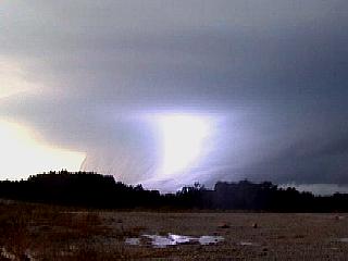
|
A bright bolt of lightning blasts through the shelf cloud of the rear-flank of the Hillsboro storm and strikes the ground ahead of it. |
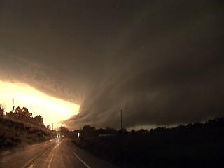
|
Here is another picture and a closer view of the rear-flank gust front / shelf cloud associated with the HP supercell southwest of Hillsboro. The color was very strange in this storm (went from yellow-brown, then green - hail - then grey). The view here is to the south and southwest, just before the storm became outflow dominant and lashed Hillsboro with strong winds and large hail. |
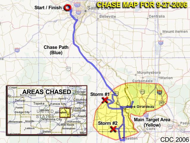
| CHASER NAME | HOME CITY | CALLSIGN | CHASE DATES | OCCUPATION |
| CHRIS COLLURA | MIRAMAR, FL | KG4PJN | 9-27 | IT CONSULTANT |
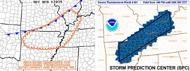
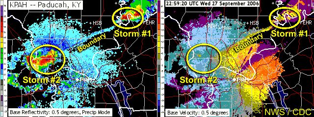
1). September 27, 5:30 PM - Interception and penetration of a severe thunderstorm in Bollinger County, Missouri and eastward through Saint Girardeau and to near Mclure, Illinois. The storm was initially encountered near the towns of Marble Hill and Whitewater along Highways 34 and SR A. The storm was a line segment with a very intense storm on its western end (upper winds were WNW, so this might have been a "tail end charley" storm). A small RFD notch was observed on the updraft base of the cell in this region, along with some small funnel clouds. The storm was supercellular briefly before evolving to a multicell cluster of severe thunderstorms. The storm's western fringe was penetrated, and penny sized hail was encountered with heavy rains and winds over 50-MPH. The storm moved quickly east into illinois and weakened a bit before moving out of reach. Lightning also occurred with this storm, and some minor tree damage was observed. The storm was caused by surface heating, a low pressure trough, surface boundary / shear axis, and strong winds aloft (upper trough and jet stream). A 2006 Ford Focus was used to chase the storms. Documentation was still digital photos and HD video. A severe thunderstorm watch was also in effect for this area until 12 AM CDT.
2). September 27, 7:30 PM - Interception and penetration of another severe thunderstorm in Scott County, Missouri from Morley to Sikeston near Highway 77. The storm was a cluster of thunderstorms containing within a posible HP supercell storm. The storm produced nearly continuous lightning with frequent and consistant CG (cloud to ground) strokes. When a portion of this storm cluster was penetrated, penny sized hail, 60-MPH (or more) winds, and torrential rains were also observed. The HP type storm embedded in this storm cluster also produced a wall cloud and possible small funnel underneath it, illuminated by the frequent lightning. An interesting swath of tree damage was also noted about 5 miles north of Sikeston after the storm moved to the east. Power was also knocked out in sections of Sikeston, MO. The storm was caused by surface heating, a low pressure trough, surface boundary interactions, an approaching cold front, and strong winds aloft (upper level disturbance). A 2006 Ford Focus was used to chase the storms. Documentation was still digital photos and HD video. A severe thunderstorm watch was also in effect for this area until 12 AM CDT.
This concludes the Chase Log for the southeastern Missouri chase trip on September 27, 2006. The summary includes a total of 2 severe thunderstorms. The main chase vehicle conducting all chases was a 2006 Ford Focus. This information was prepared exclusively for the National Weather service and the team of Skywarn storm spotters.
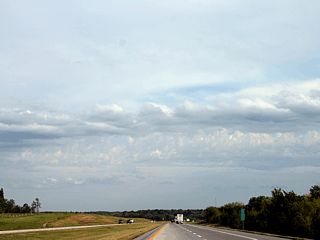
|
Looking south on Interstate 55 about 15 miles north of Cape Girardeau, Missouri, evidence of a surface boundary is denoted by a line high-base cumulus clouds. This is not the actual cold front, but a wind-shift line (shear axis) where southerly winds and higher dewpoints (more moisture) to the south give way to drier air and more westerly winds to its north. Severe thunderstorms often develop along and near such important boundaries because air is being lifted up along them (called forcing). |
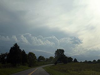
|
A thunderstorm cell initiates (begins to develop) as a cluster of enhanced cumulus clouds along the same boundary which rises high enough to form cumulonimbus clouds. The view is to the west and the storm is developing near Marble Hill, Missouri. Upper-level winds are WNW so the storms "rear flank" will be on its west and northwestern side. |
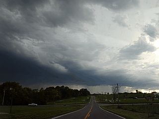
|
In this picture, also looking west, the updraft base and vertical structure of the now severe-warned storm becomes apparent. The intense precipitation core is developing to the far left. |
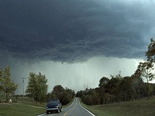
|
Here is a nice view of the rain-free base of the severe thunderstorm upfdraft. Note the little funnel appearing directly above the passing car on the road in this picture. |
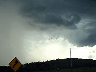
|
This is a picture of a small region of rotation, indicating the storm may have briefly became a supercell, on the rear-flank of the storm and updraft region. The view is to the west (remember, the rear-flank of a NW flow storm is on its NW side). The hint of an RFD (clearer) area is in the center of the picture. The hail core is to the left. Note the little "swirl" in the rain-free updraft base and lowering to the far right. |

|
Here is a picture of a rain (or hail) bow that formed on the southwestern side of the severe thunderstorm as it was near Whitewater, Missouri. I am now behind a storm that is racing eastwards at 40 MPH. Note the whitish green color of the sky (hail). |
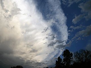
|
As the severe storm moves on into Illinois, a great view of the beack-sheared anvil and western portion of the anvil "rollover" can be seen. The view here is to the southeast near Mclure, Illinois. |
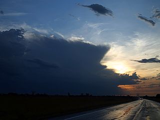
|
Another severe thunderstorm complex develops farther to the southwest near Poplar Bluff, Missouri. In this picture, looking WSW from Highway 146 in east Cape Girardeau, Illinois, the storm complex is to the left and about 35 miles away. The storms are moving east at 35-40 MPH and I am in front of them, so I forfeit the Illinois storms and turn my attention to the ones I am now in the path of intercepting. |
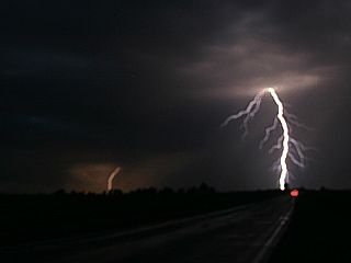
|
I set up about 10 miles to the east of the second severe thunderstorm cluster, and begin shooting digital stills of the frequent and very photogenic lightning. In this picture, it's a bit blurry as I am still adjusting the camera's focus (Canon Digital Rebel with bulb setting and cable release). This is just west of Morley, Missouri and along the right side of Highway 91. |
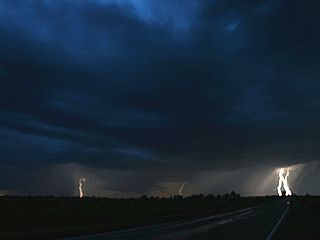
|
A wall cloud becomes visible with many flashes of the frequent lightning to my west and southwest. The wall cloud is associated with an HP supercell storm embedded in the cluster of thunderstorms. The view here is right into the inflow "notch" of this supercell storm. The wall cloud is just a hair left of the center of this picture just above the ground. Note the inflow "banding" to the upper left too. |
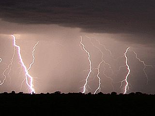
|
Here is a great picture of multiple cloud to ground (CG) lightning strokes from a time-exposure of about 20-25 seconds looking southwest. |
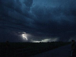
|
This is a video frame-capture of the wall cloud to my west with slightly better illumination by the lightning. Lots of inflow banding visible again to the upper left. |
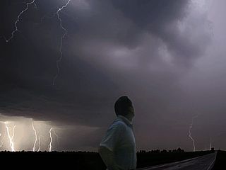
|
Here is a self portrait of myself watching the "show" of lightning. This is NOT a "Photoshopping" of me added into an existing lightning shot, this is how it looked if you were actually there. Contrast and focus adjustments were the only touching-up done to this image. |
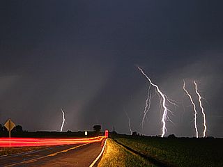
|
With the storm drawing closer, here is a shot up the road (to the west on Highway 91) with a time-exposure of a passing car headed right into the "lightning core"! |
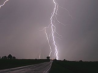
|
This is a zoomed in shot up the road (Highway 91) with a nearly perfectly centered CG lightning hit. Note the bolt also captured to the far upper left corner. |
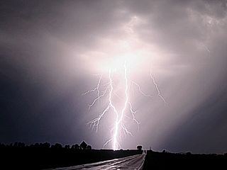
|
Here is another brilliant and hot CG lightning hit to the end of Highway 91. Now it is time to move, storm is close and it's too dangerous to stay outside. |
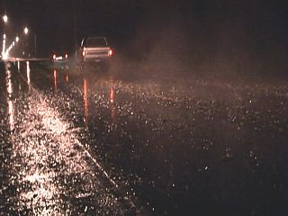
|
Here is a picture of some damage observed south of where the storm cluster (and possible the HP storm, or what was left of it) passed. This is along highway 61 about 5 miles north of Sikeston, MO. Some branches, and numerous twigs and leaves were scattered across this roadway in a path about 200 yards wide (microburst)? |
|
Some areas of Sikeston, MO lost power from the storms, like this dark store front. Stopping for gas was fun too, as I finally paid $1.96 a gallon after having not paid under $2 in about 2 years. The gas pump charged me $69.00 for 7 gallons of gas, which was more than likely a power issue from lightning hosing the computer up! The gas station clerk in Sikeston was helpful and manually charged me the right amount. |
HTML File "mwcl2006.htm" - Developed By Chris Collura
To Return To The HOME Page Of This Site Click The "INDEX.HTM" Link Here!