
| This section is for both the first and main-planned storm chase expedition to the US Great Plains for mid-late May of 2005 as well as a second trip in mid June. My portion of the first trip was origninally from May 13 through May 30, 2005 but the return date was extended until June 1. There was a total of 20 travel days, of which, 19 of these days were available for chasing (day 20 was a travel day). In these days, there were 14 chase days, 4 travel / down days, and 2 "bust" days. The main "Weathervine" storm intercept team headed out on May 11 and return on June 1 via a Dodge Caravan rental. We were "based" out of Dallas, Texas where I flew out met them on May 13, 2005 and chased until June 1, 2005 where I cancelled my return flight on May 30 and returned with them on June 1. The second and shorter storm chase expedition to the US Great Plains was made by myself in spite of a rather quiet May tornado-wise for the first trip. The second trip was from June 9 to June 13 with a total of 5 travel days, of which, 3 of these days were available for chasing (first and last days were a travel days). In these days, there were 3 chase days and 2 travel days. I flew into Dallas late on the evening of June 9 and chased until June 13, 2005 where I returned on the afternoon back to Florida. June 12 was a chase-day to remember, which involved a cyclic supercell that produced at LEAST EIGHT tornadoes! Both of these trips were my sixth and seventh dedicated to severe thunderstorm research in this area, which includes the Great Plains and the Midwestern United States. Keep in mind that this chase log is scientific evidence and portrays my on-going storm chasing research. It has been placed on this page for easy reference and meteorological interests. Please do not plagiarize or copy this document to other sites for distribution. Note - This page may take a while to load on some SLOWER connections! |
 Chase 2005 Music Video (NSCC 2006)
| CHASER NAME | HOME CITY | CALLSIGN | CHASE DATES | OCCUPATION |
| CHRIS COLLURA | MIRAMAR, FL | KG4PJN | 5-13 TO 6-1 | IT CONSULTANT |
| JEFF GAMMONS | OKEECHOBEE, FL | KG4PGA | 5-11 TO 6-1 | PHOTOGRAPHER |
| KERSTEN MC CLUNG | OKEECHOBEE, FL | N/A | 5-11 TO 6-1 | HOSTESS |
The participants below, with the exception of Amos Magliocco, are not from the "Weathervine" chase team. These people often actively participate in our storm research efforts and deserve appreciation for their great help and severe weather expertise. Jason Persoff was kind enough to offer "acute care" to fellow chasers during our trip. Congratulations to Scott Blair and Eric Nguyen for officially graduating from their studies into the field of meteorology!
| CHASER NAME | HOME CITY | CALLSIGN | OCCUPATION |
| AMOS MAGLIOCCO | BLOOMINGTON, IN | KC5VPD | WRITER |
| BILL HARK | VIRGINIA BEACH, VA | KV0RTX | ALLERGIST MD |
| ERIC NGUYEN | NORMAN, OK | KD5HPZ | METEOROLOGIST |
| JASON PERSOFF | JACKSONVILLE, FL | KB0YJW | INTERNAL MEDICINE MD |
| SCOTT BLAIR | FORT SMITH, AR | KD5KOW | METEOROLOGIST |
| SCOTT CURRENS | NORMAN, OK | KE5AIV | STUDENT |
| SCOTT EUBANKS | DALLAS, TX | KC5DES | POSTAL WORKER |
| TONY LAUBACH | LITTLETON, CO | KC0ONL | STUDENT |
Please note that several other chasers may caravan or "converge" with us.
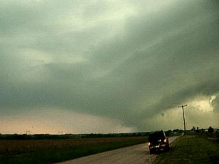
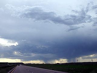
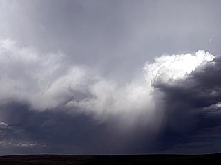
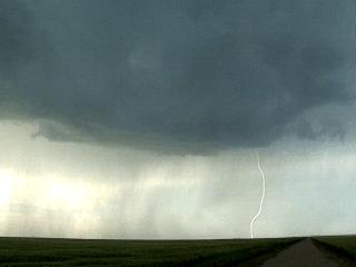
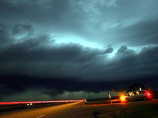
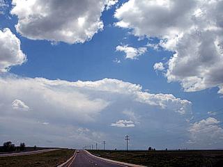
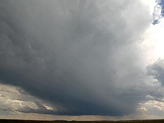
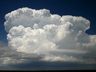
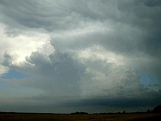
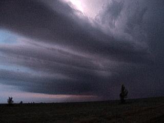
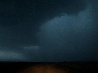
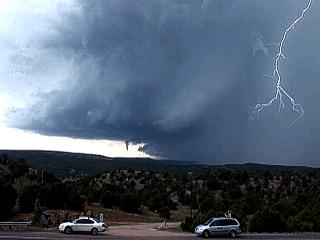
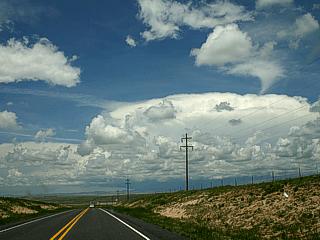
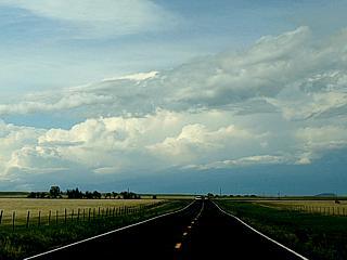
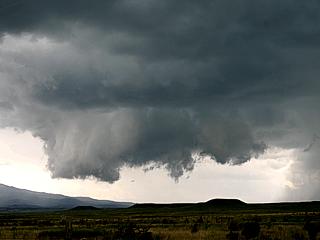
May 13 - Arrival day and supercell chase day in NW Texas! Straight from Dallas-Fort Worth, headed west-northwest on 287 passing Witchita Falls and reached Quanah in time for storm initiation. Headed south on Highway 6 watching the storm build to the west, become supercellular, and split. The right split was followed south through Cromwell where it reached its peak. The storm was both classic and HP depending on its cycle and evolution. At least 2 small tornadoes were observed with this storm. About 150 storm chasers "converged" on this storm, from "Yahoos" to the DOW trucks, making Highway 6 a traffic jam! The storm weakened near Haskell, Texas along 380 and the chase ended with another storm developing behing the original storm, a cluster by that time, dropping hail on us in Haskell. The chase ended with a drive back to Witchita Falls to spend the night. Great first day!
May 14 - Down day and time to set up the vehicle with equipment. Left Witchita Falls and headed through Lubbock, Texas to Brownfield, Texas to stay the night anticipating chase prospects in SE New Mexico the following day.
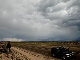
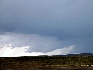
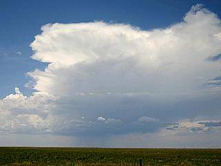
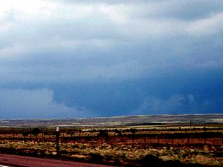
May 15 - Marginal chase day in New Mexico west of Roswell. Cool and moist upslope setup allowed us to chase in this area. We left Brownfield, TX and headed west on Highway 380 to Roswell, New Mexico. We targeted convection developing near the front range 10 to 15 miles west of Roswell along Highway 380. The storm briefly became supercellular, with a wall cloud and beaver's tail, but never had the parameters to sustain itself. We finished the chase, ate dinner in Roswell, then headed to Amarillo, Texas via Highway 70 to position for the next day s chase possibilities.
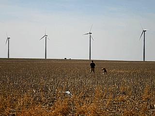
May 16 - Down and travel day. Today did not present good chase prospects, so most of the day was spent traveling from Amarillo, Texas to Colby, Kansas via Highway 83 as good chase prospects were anticipated the next day. On the way, we did stop at the rock monuments and windmill farms for photo opportunities.
May 17 - Today was a good chase day with a small tornado intercepted south of Cozad, Nebraska. The day began in Colby, Kansas. We waited there checking data at the "Oasis" off I-70, then left for Hoxie, Kansas to wait some more. At 3:45 PM we headed north on Highway 23 through Mc Cook, Nebraska then east on I-80 out of North Platt. The storms were targeted east of North Platt and a supercell storm on the south end of the line segment was targeted south of I-80 near Cozad. South of this area a dusty tornado was observed before being cut off by outflow. The line segment was followed southeastward on Highway 6 through Mindon, Nebraska. The line segment contained embedded supercell features. The chase ended by driving back southeast to Salina, Kansas for the night.
May 18 - Chase day with supercell thunderstorm intercepted southeast of Topeka, Kansas. We started in Salina, Kansas and headed towards the general area of eastern Kansas targeting good moisture (dewpoints) and instability. We waited in Emporia, Kansas for initiation and went after the developing thunderstorms near Topeka. The storm became an HP supercell with incredible structure at time of observation. This storm evolved to multicell and back-built southward into southeastern Kansas near Burlington. The chase ended in Lola, Kansas with the night spent in Chenute, Kansas.
May 19 - Today was a typical cap "bust" day in Northeastern Oklahoma. Anticipating good directional shear and instability, we left Chenute, Kansas and headed for Tulsa, Oklahoma stopping in Bartelsville, Oklahoma for data on the way. The capping inversion never broke, and the enhanced cumulus waned by 6 PM. We left Tulsa by 6 PM and headed north to Wichita, Kansas for a weather channel interview in the morning the next day and possibilities farther north in South Dakota.
May 20 - A very long chase on a marginal chase day with very little in the way of storms found. The chase started in northern Wichita, Kansas northward on I-35 then Hoghway 81 through Kansas and Nebraska into South Dakota. There were two targets forecasted, SE North Dakota and SE Montana. There was many delays in Nebraska due to almost continuous construction. Unfortunately, there was simply not enough time to make them as we got to a late start as the Weather Channel Interview fell through. Both targets produced supercells. We ended up in south central South Dakota and headed west on I-90 targeting a severe thunderstorm near the SD / NE central border near the Missouri River. The storm went LP, then high based / low topped and weakened. This VERY frustrating chase ended by tracking back south into O'Neill, Nebraska for the night.
May 21 - Today was another beautiful setup gone to crap in a nasty and painful "bust". We forecasted and left O'Neill, Nebraska at about 11 AM targeting Norfolk, Nebraska. Some small cumulus started appearing as we met up with Eric Nguyen, Scott Currens, Scott Eubanks, Tony Laubach, and others. We remained in Norfolk until about 4 PM then headed southward into the area north of Interstate 80 east of Wahoo, Nebraska. We waited there under great upper level dynamics, a surface low, warm and cold front boundaries, but a strong "cap" of warm air aloft that just held strong. We accepted the fact that we "busted", despite tornado watch 311 issued for the area, ate in Lincoln, Nebraska and resorted back west on I-80 spending the night in York, Nebraska. Tomorrow we will head west to play upslope in a day or so in Colorado.
May 22 - What was supposed to exclusively be a travel day turned out to include an unexpected interception of severe thunderstorms en-route to our Colorado Target. We left York and stopped in Grand Island for food and vehicle maintenance. We proceded west on I-80 stopping in Kearney to check out the Archway Monument museum. We continued west on I-80 towards Cheyenne, Wyoming and intercepted some severe storms near Bushnell and Kimball, Nebraska. We continued observing the storms as we worked our way south and southwest clipping extreme Southeastern Wyoming and entering the Palmer Divide area of Northeastern Colorado. We documented the storms, even stumbling across a missile silo where some military personell politely asked us to leave. We finished with the storms then continued south and southwest through rural Colorado alongside Bison and Antelope. We settled for dinner and the night in Greely, Colorado at a pretty interesting (in a deviant way) Motel 6.
May 23 - A moderately successful chase day in Eastern Colorado / Western Kansas. The day began sort of uptight leaving the "suspicious" motel in Greely, Colorado. We did manage to visit NCAR (National Center for Atmospheric Research) in Boulder, Colorado before heading out of town to chase near Limon. A high-based LP supercell was encountered southwest of Limon, and followed eastward towards Kit Carson where it weakened after a "just in time" fuel stop. We headed east on Highway 40, then north on Highway 21 into Goodwell, Kansas for the night. Another electrically active severe thunderstorm was observed while in Goodwell.
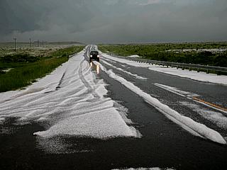
May 24 - A long and busy chase day with at least four severe thunderstorms, all of them supercells intercepted. The day began by leaving Goodwell, Kansas and heading west then north to near Akron, Colorado. The first storm, an LP supercell couplet (two cells, one clockwise, the other counter-clockwise) was encountered northwest of Last Chance, Colorado after initiation. A second supercell, embedded in a squall line, was encountered near Akron before heading south to yet another supercell south of Joes, Colorado with a large rotating wall cloud. These storms weakened, so attention was directed to the southern "tail end charley" cell on the cluster of storms. This required going south, then east on 70, then south on Highway 29 back in Kansas to target rotating storms west of Tribune, Kansas. We were pulled over and verbally warfned for speeding north of Tribune, Kansas. West of Tribune, then across the Colorado border near Towner, a violent HP (high precipitation) supercell was encountered near dark. This storm occuluded and bowed-out as it moved southeast sending a violent severe storm through Syracuse, Kansas. We backed off back east to Tribune, Kansas, then south on Highway 29 to wait for the storm to pass near Syracuse, Kansas. After the storm passed, we continued west to Lamar, Colorado for the night.
May 25 - Today was another great chase day with three supercells intercepted. We left Lamar, Colorado and headed southwest through Trinidad, and took Interstate 25 out of the mountains and headed south. We entered the warm sector ahead of a cold front near Raton, New Mexico and stopped to observe a developing LP supercell southwest of Springer, New Mexico. This storm was a well-developed LP supercell storm, but did not get very well organized. A new storm EXPLOSIVELY developed ahead of the cold front to the northeast of the LP storm and went from fair-weather cumulus to a full-fledged classic supercell in only a half hours time! This storm wrapped up and had some of the most rock-hard "cauliflower" updrafts I have ever seen. The storm became undercut by the cold front but persisted for a while as it evolved to an LP storm, became elevated, and dissapated. Attention shifted towards storms near Tucemcari, New Mexico. Southeast of this area, another supercell storm explosively developed and became a mature storm in about twenty minutes. This supercell also became undercut by the cold air surging southward, but turned right maintained supercell status (classic and LP) for some time. Giant hail (nearly baseball sized) was observed with this storm along with incredible storm structure northwest of Logan, New Mexico. The hail was encountered again at a gas station, but smaller, in Logan. This was the last storm of the day, so we headed west into Clovis, New Mexico for the night.
May 26 - Today was a down day. We left Clovis, New Mexico and toured the Carlesbad Caverns national park area southwest of Carlesbad, New Mexico area. No storms developed this day. The evening was spent in Roswell, New Mexico positioning for possibilities in NE New Mexico again the next day.
May 27 - Today was a fun chase day with a cyclic supercell encountered near Las Vegas, New Mexico. The day began leaving Roswell, New Mexico after forecasting our target area in Las Vegas, New Mexico. We arrived in our target area in time for initiation. The storm quickly became an LP supercell, then classic, and ultimitely HP near Interstate 40. This storm was spectacular, and its hail core was also documented. We wrapped up the chase and headed to Amarillo, Texas for the night. The next day should be a Kansas chase day.
May 28 - Two supercells were intercepted on this chase day, one in eastern Colorado, and another in SE Colorado and chased into the Oklahoma Panhandle. We left Amarillo, Texas after forecasting and deciding between chasing or attending the Storm-Track picnic. We decided to chase, so we headed to east-central Colorado near Kit Carson. Storms initiated and a small supercell was intercepted southeast of Burlington, Colorado. This storm came close to producing a tornado, but occluded and weakened near the Kansas border. We headed back south and west to Lamar, Colorado through the northern portion of linear storms south of the area. Upon leaving Lamar, headed south, the southern end of the line of thunderstorms evolved into another supercell (Tail End Charley) which was intercepted at sunset and chased into the night. This storm was one of the most beautiful and majestic a supercell can be. After this storm weakened late, we blasted south through the Oklahoma panhandle and back into Texas. The night was spent in Amarillo, Texas. The next day should be a final chase day.
May 29 - Today was another chase day where two supercell storms were intercepted from near Abbott, New Mexico then northward near Trinidad, Colorado. The day began by leaving Amarillo, Texas and heading west to the area near Abbott, New Mexico where the first storm fired. This storm briefly wrapped-up as a supercell but quickly became outflow dominant. The second storm was intercepted near Trinidad, Colorado by quickly re-positioning northward then east of Trinidad. Hail covering the ground was encountered behind this storm. After finishing the chasing, the night was spent in Trinidad, Colorado. The next few days may be very interesting, so the return date of May 30 was moved up to June 1.
May 30 - This day was supposed to be a travel day, but the trip was extended and this day was a very interesting chase day with nearly five supercell thunderstorms intercepted, one of which produced a funnel cloud and another producing a tornado. We looked at data in Trinidad, Colorado and realized the place to be was just east of Trinidad. Convective initiation occurred at about 3 PM so we headed east on Highway 160 east of town. About three supercells developed and trained off the high terrain but were short-lived. The second supercell of the three produced an impressive rotating wall cloud. Amos Magliocco (KC5VPD) who was also caravaning with our group accidentally hit a deer that darted in front of him causing damage to his vehicle. A fourth supercell was encountered farther east and produced a striking wall cloud and funnel north of Branson, Colorado. The final supercell was a violently rotating storm that crossed Highway 160 southwest of Pritchett, Colorado where giant hail and a tornado was observed. Another chaser in our group, Jason Persoff, needed to be pulled out of a ditch after his car slidded into it. After following this storm to near Springfield, Colorado we ended the chase and headed farther south to set up for the final chase day's target area spending the night in Dalhart, Texas.
May 31 - Today was an exciting chase day in western Texas with two supercells interecepted, one of which produced giant hail and a tornado. We left Dalhart, Texas after forecasting and headed to our primary target area north of Lubbock and south of Plainview. Storms began developing north of the area, and one HP supercell was observed just before it weakened. Another storm fired near Clovis, New Mexico, and moved into Texas. This storm became an LP, then a classic supercell northwest of Lubbock. A weak tornado was observed with this storm, and baseball sized hail was encountered damaging the chase vehicle. The chase continued southeast of Lubbock where the storm "gusted out" and the chase ended in La Mesa, Texas for dinner. We began the long drive home after dinner heading east on I-20 through Dallas by midnight.
June 1 - Departure and travel day. Today was strictly a travel day spent on a long roadtrip back to Florida. Ongoing driving from the previous chase day through Longview, Texas on I-20, then taking I-49 through Louisiana, then I-10 through Mississippi, Alabama, and into North Florida. We traveled down I-75 passing Gainseville then picking up the Florida Turnpike to drop the rental vehicle back in Orlando and pick up my personal car at the airport parking lot. This concludes the trip for chase expedition 2005.
1). May 13, 3:00 PM - Observation of an extremely severe thunderstorm west of Highway 6 between Crowell and Quanah in Texas. The storm was encountered just after initiation and rapidly intensified into a supercell thunderstorm. The storm split, and the southern cell (right moving storm) was targeted. This storm was to go through several cycles and produce small tornadoes during this period, eventually evolving from a classic supercell, to an HP storm, with the "stacked-plates" effect, then occlude and evolve to a multicell cluster. The storm contained 3" hail, which was not observed. The storm also produced torrential rains, frequent lightning with close hits, and inflow winds to-50 MPH. A violently rotating wall cloud was observed with the supercell during its classic stage near Crowell, and a possible tornado was observed with it. Another dusty weak tornado was observed east of Knox City while taking refuge under a car port with the permission of a friendly local. In this area, hail to 1" was also observed with part of this storm along with frequent lightning, 60-MPH winds, and heavy rains. The storms became multicellular and weakened by about 8:00 PM. The storms were caused by a strong upper-level disturbance, dryline bulge, weak surface low, and pre-existing boundary. A 2005 Dodge Caravan was used to chase the storm. Documentation were digital stills and camcorder. A tornado watch was also in effect for this area until 9PM CDT.
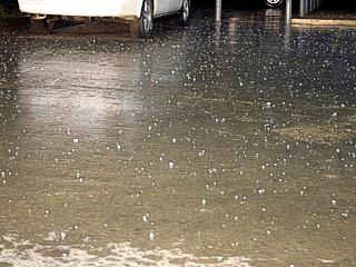
2). May 13, 9:30 PM - Observation of a severe thunderstorm in Haskell, Texas near Highway 287 along Highway 380. This storm was part of a multicellular cluster of strong a severe thunderstorms developing behind previous activity closer to the dryline boundary to the west. Frequent lightning, heavy rains, hail at least 1", and winds to 35-MPH were observed at a gas station with this storm. The storms were caused by a strong upper-level disturbance, dryline bulge, weak surface low, and outflow boundary. A 2005 Dodge Caravan was used to chase the storm. Documentation was a camcorder.
3). May 15, 5:00 PM - Observation of a severe thunderstorm west of Roswell, New Mexico and just northwest of Highway 380. The storm began from upslope convection and was about 10-15 miles west of Roswell. The storm began as multicell thunderstorms, rather high-based, then one cell acquired supercell characteristics in the cluster. The storm produced hail, but this was not intercepted. A weakly rotating wall cloud and beaver's tail appeared on the storm during its highpoint. The storm also produced frequent lightning. The storms were caused by upslope wind flow, a low-pressure trough, and an upper-level disturbance. A 2005 Dodge Caravan was used to chase the storm. Documentation was a camcorder and digital still photos.
4). May 17, 6:30 PM - Observation of a severe thunderstorm and tornado south of Cozad, Nebraska from just south of Interstate 80 in Lincoln County eastward and southeastward into Minden, Nebraska. The storm involved was the "Tail End Charley" storm on the south end of a line segment / cluster of severe thunderstorms. The supercell storm on the southernmost end of this line was semi-linear but contained rotation and was able to produce a weak dusty tornado on its updraft side 5 miles or so south of Cozad. The storm continued to back-build and adopted inflow winds gusting over 50-MPH at one point with the "stacked-plates" effect visually. The storm core had hail to 3 inches and 70 MPH winds (not intercepted). The storm developed ahead of a cold front and dryline "punch" interaction, and was triggered by surface heating and an upper-level disturbance / jet stream aloft. A 2005 Dodge Caravan was used to chase the storms. Documentation was still digital photos and a camcorder. A severe thunderstorm watch was also in effect for this area until 9 PM CDT.
5). May 18, 8:00 PM - Interception of an extremely severe thunderstorm southeast of Topeka, Kansas near Highway 75. The storm was an HP supercell producing golfball hail (or larger) and funnel clouds. A large wall cloud was observed with this storm, with tiered shelf cloud structure. The hail was not intercepted. The storm produced heavy rains and frequent lightning. The storm evolved to a multicell cluster with bow-echo and was followed to Burlington, Kansas. The storms developed ahead of a cold front and outflow boundary coupled with surface heating and an upper-level disturbance. A 2005 Dodge Caravan was used to chase the storms. Documentation was still digital photos and a camcorder. A severe thunderstorm watch box was in effect for the area until 10 PM CDT.
6). May 20, 8:30 PM - Observation of a severe thunderstorm developing near the Missouri River in south central South Dakota about 45 miles south of Interstate 90. The storm was a small LP type supercell that evolved to a high based / low topped elevated storm and subsequently dissapated. The storm was observed mature from about 75 miles away. The storm developed from surface heating and an upper-level disturbance ahead of a low pressure system. Documentation was still digital photos. A 2005 Dodge Caravan was used to chase the storm.
7). May 22, 7:30 PM - Interception of a strong to severe thunderstorm near Bushnell, Nebraska. The storm was high-based and elevated but produced pea to dime sized hail as we penetrated its small precipitation core during the weakening stages of the storm. The storm was part of a multicell cluster of elevated strong and severe thunderstorms. The storms were caused by surface heating, upslope winds, and an upper-level disturbance. A 2005 Dodge Caravan was used to chase the storms. Documentation was still digital photos and a camcorder.
8). May 23, 6:00 PM - Observation and interception of a severe thunderstorm southwest of Limon, Colorado and followed eastward to near Kit Carson, Colorado. The storm began as a rotating LP supercell with a high base. The storm tried to intensify, but weakened near Kit Carson. Marble sized hail, 60-MPH winds, frequent lightning, and heavy rains were observed with this storm. The storms were caused by surface heating, a low pressure trough, upslope wind flow, and an upper level disturbance. Documentation was still digital photos, audio, and a camcorder. A 2005 Dodge Caravan was used to chase the storms. A tornado watch was also in effect for the area until 2 AM CDT.
9). May 23, 9:00 PM - Indirect penetration of another severe thunderstorm in Goodwell, Kansas. This storm was part of a multicell cluster of severe thunderstorms. Moderate rain, frequent lightning, and winds gusting to 60-MPH were observed with this storm. Some signs were blown down in Goodwell from the wind gusts. Documentation of this storm was a camcorder and still digital photos. A 2005 Dodge Caravan was used to chase the storms. The storms were caused by surface heating, a low pressure trough, outflow boundaries, and an upper level disturbance. A tornado watch was also in effect for the area until 2 AM CDT.
10). May 24, 4:00 PM - Observation of a strong to severe thunderstorm northwest of Last Chance, Colorado. The storm was a small LP supercell storm (cyclonic), and eventually merged with another left-split LP storm (anticyclonic). When the two storms merged, the RFD "slot" became enhanced and a horseshoe updraft base became relevant. The storm weakened after that. Frequent lightning, 30-MPH winds, light rain, and pea-sized hail was observed with the storm. The main core was not penetrated. The storms were caused by a low-pressure trough, upslope winds, surface heating, and an upper-level disturbance. A 2005 Dodge Caravan was used to chase the storm. Documentation was a camcorder and still digital photos. A tornado watch was in effect for the area until 9PM MDT.
11). May 24, 6:00 PM - Indirect penetration of a severe thunderstorm near Akron, Colorado off Highway 34 and Highway 63. Winds gusting to 50-MPH, heavy rains, frequent lightning, and small hail was observed with this storm. The storm also spawned some small funnel clouds on its updraft side southeast of Akron. The storms were caused by a low-pressure trough, outflow boundaries, surface heating, and an upper-level disturbance. A 2005 Dodge Caravan was used to chase the storm. Documentation was a camcorder and still digital photos. A tornado watch was in effect for the area until 9PM MDT.
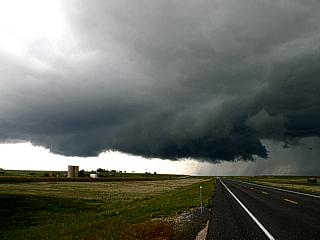
12). May 24, 7:00 PM - Penetration and observation of another severe thudnerstorm southeast of Joes, Colorado near Kirk. The storm was an HP supercell storm with a very large wall cloud. The wall cloud was observed rotating before becoming rain wrapped. Attempting to flank the storm to the north, part of its core was penetrated, and 60-MPH winds, torrential rains, frequent lightning with close hits, and hail to 3/4" was encountered. The storms were caused by a low-pressure trough, outflow boundaries, surface heating, and an upper-level disturbance. A 2005 Dodge Caravan was used to chase the storm. Documentation was a camcorder, audio, and still digital photos. A tornado watch was in effect for the area until 10PM CDT.
13). May 24, 9:00 PM - Observation of an extremely severe and possibly tornadic thunderstorm near Towner, Colorado west of Tribune, Kansas, then south through Syracuse, Kansas where its core was encountered. The storm began as an HP supercell, producing continuous lightning and funnel clouds. Near this storm, torrential rains, frequent lightning, and 3/4" hail was observed in the forward-flank region (well northest of the core). The storm evolved to a bow segment and blasted through Syracuse, Kansas, where winds gusting over 80-MPH were encountered, with frequent lightning, violent rain, and hail up to 1/2" inch. The storm cause flooding and some trees down. The storms were caused by a low-pressure trough, upslope winds, surface heating, and an upper-level disturbance. A 2005 Dodge Caravan was used to chase the storm. Documentation was a camcorder, audio, and still digital photos. A tornado watch was in effect for the area until 5AM MDT.
14). May 25, 4:00 PM - Observation of a severe thunderstorm developing southwest of Springer, New Mexico west of Interstate 25. The storm was an LP supercell storm. Its core was not penetrated. Frequent lightning and a wall cloud was observed with this storm. The storm was caused by upslope wind flow, an upper-level disturbance, surface low-pressure, and surface heating. A 2005 Dodge Caravan was used to chase the storm. Documentation was still digital photos, and a camcorder. A severe thunderstorm watch was in effect until 9PM MDT.
15). May 25, 6:00 PM - Observation of a very severe thunderstorm northeast of Springer, New Mexico west of Interstate 25. This storm was an extremely rapidly developing storm with rock-hard explosive thunderstorm development. The core of this storm was not penetrated, but its inflow side was viewed for the life of the storm. Several rotating wall clouds were observed with this classic supercell. After the cold front undercut its updraft, the storm slowly evolved to an LP storm, became elevated, and weakened. Winds over 50-MPH were onserved near the edge of this storm. The storm was caused by a cold front, an upper-level disturbance, surface low-pressure, and surface heating. A 2005 Dodge Caravan was used to chase the storm. Documentation was still digital photos, and a camcorder. A severe thunderstorm watch was in effect until 9PM MDT.
16). May 25, 9:00 PM - Interception and direct penetration of an extremely severe thunderstorm southeast of Tecumcari, New Mexico and south of Interstate 40. This storm also explosively developed and quickly became a classic supercell, then evolved to HP when undercut by the cold front it developed along. In the HP stage, the hail core was sampled (penetrated) where hail over 2 inches was observed (near baseball hail). Torrential rains, frequent lightning, and winds over 60-MPH were also encountered with this storm. The storm also produced a few rotating wall clouds and small funnels before being undercut. After penetrating the storm core, the storm moved south and southeast to near Logan, New Mexico, where the storm evolved to LP. Marble to quarter sized hail was observed again at a gas station in this area before the storm weakened. The storm was caused by a cold front, an upper-level disturbance, surface low-pressure, and surface heating. A 2005 Dodge Caravan was used to chase the storm (Weathervine team) as well as a 2002 Ford Taurus (Scott Blair) for the hail observations. The hail size was reported to the National Weather Service office. Documentation was still digital photos, audio, and a camcorder. A severe thunderstorm watch was in effect until 9PM MDT.
17). May 27, 5:00 PM - Interception and direct penetration of an extremely severe thunderstorm from near Las Vegas, New Mexico to near Interstate 40 and Highway 3. The storm initiated in the mountains near Las Vegas and quickly became supercellular near Interstate 25. The storm began as LP, then evolved to classic, producing many wall clouds and funnels during its lifetime. The storm acquired the "stacked plates" structure and pea to dime sized hail fell from its anvil. The storm came very close to producing a tornado near Interstate 40 during its HP evolution. Inflow winds over 50-MPH were found in this area. The core of this storm was also penetrated, where golfball sized hail (or larger) fell thick and covered the ground up to several inches deep (completely white like snow)! The core also had frequent lightning and winds to near 70-MPH. The storm subsequently evolved to a bow-segment then became outflow-dominant and weakened. The storm was caused by a low pressure trough, an upper-level disturbance, upslope wind flow, and surface heating. A 2005 Dodge Caravan was used to chase the storm (Weathervine team) as well as a 2002 Ford Taurus (Scott Blair) for the hail observations. Documentation was still digital photos and a camcorder. A severe thunderstorm watch was in effect until 8PM MDT.
18). May 28, 5:00 PM - Observation and indirect penetration of a severe thunderstorm southeast of Burlington, Colorado. The storm was a classic supercell thunderstorm and had a well-developed RFD and rotating updraft. Several wall-clouds and funnels were noted with this storm before it weakened. Inflow winds were southeast at about 40-MPH into this storm. Copious amounts of pea to dime sized hail, winds near 60-MPH, heavy rains, and frequent lightning was observed with this storm. The storm was caused by a low pressure trough, an upper-level disturbance, upslope wind flow, and surface heating. A 2005 Dodge Caravan was used to chase the storm. Documentation was still digital photos and a camcorder. A severe thunderstorm watch was in effect until 9PM MDT.
19). May 28, 9:30 PM - Observation and penetration of a very severe thunderstorm southeast of Springfield, Colorado and followed into the central Oklahoma panhandle after dark. This was a supercell storm that began as the southernmost cell on a line of thunderstorms. The storm back-built and separated from the line and became organized (the "Tail End Charley" storm). This supercell began as a classic supercell and evolved to HP before becoming outflow dominant after several hours. Marble sized hail to about 1" was observed on the rear-flank of this storm. The hail covered the ground and roadway in some places. Torrential rains and frequent lightning was also observed with this visually striking storm, which even took on the "stacked plates" appearance for some time after dark. The storm was caused by a low pressure trough, an upper-level disturbance, outflow boundaries, and surface heating. A 2005 Dodge Caravan was used to chase the storm. Documentation was still digital photos, audio, and a camcorder. A severe thunderstorm watch was in effect until 9PM MDT.
20). May 29, 4:00 PM - Interception of a severe thunderstorm along Highway 56 east of Abbott, New Mexico. The storm was a supercell storm that quickly became outflow dominant and evolved into a line segment producing 50-60 MPH outflow winds. The storm also produced pea to dime sized hail, frequent lightning, and very heavy rains. A large wall cloud and some funnels were produced by the storm before the storm updraft region became undercut by the outflow. The storm was caused by a low pressure trough, an upper-level disturbance, upslope windflow, and surface heating. A 2005 Dodge Caravan was used to chase the storm. Documentation was still digital photos and a camcorder. A severe thunderstorm watch was in effect until 8PM MDT.
21). May 29, 7:00 PM - Observation of another supercell storm north and east of Trinidad, Colorado east of Interstate 25 along Highway 160. The storm weakened when it was reached, but a large hail swath was encountered behind this storm along Highway 160. Marble sized hail covered the ground in areas and flash flooding was also observed. The core of this storm was not penetrated. The storm was caused by a low pressure trough, an upper-level disturbance, upslope windflow, and surface heating. A 2005 Dodge Caravan was used to chase the storm. Documentation was still digital photos and a camcorder. A severe thunderstorm watch was in effect until 8PM MDT.!
22). May 30, 4:00 PM - Observation of three severe thunderstorms, each short-lived classic and / or LP supercells, near Highway 160 east of Trinidad, Colorado. Each of these storms developed in the high terrain and moved to the east and northeast. Frequent lightning, hail up to dime sized, 40-MPH winds, and moderate to heavy rains were observed with each of these storms. Their cores were not directly penetrated. The second of these storms produced a large and rotating wall cloud. The storms were caused by a low-pressure system, upper-level dynamics, up-slope wind flow, and surface heating. A 2005 Dodge Caravan was used to chase them. Documentation was a camcorder, still digital photos, and audio. A tornado watch was in effect for the area until 9PM MDT.
23). May 30, 7:00 PM - Observation of another severe thunderstorms, a classic / LP supercell, 3 miles south of Highway 160 north of Branson, Colorado. This storm produced a dramatic vault and large wall cloud, and a persistant funnel was noted under the wall cloud for about 5 minutes. The funnel did not touch down. Frequent lightning, hail up to dime sized, 30-MPH winds, and moderate rains were observed with this storm before it moved northeast and weakened. The small core of this storm was not directly penetrated. The storm was caused by a low-pressure system, upper-level dynamics, up-slope wind flow, and surface heating. A 2005 Dodge Caravan was used to chase them. Documentation was a camcorder and still digital photos. A tornado watch was in effect for the area until 9PM MDT.
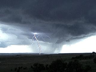
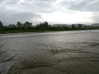
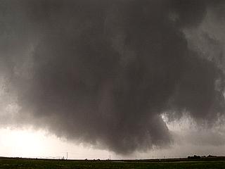
24). May 30, 9:00 PM - Observation and indirect penetration of a tornadic supercell southwest of Pritchett, Colorado along Highway 160. This was a classic supercell with an incredible vault structure and produced a brief tornado north of the highway. Frequent lightning, hail larger tham golfballs, 60 to 70 MPH winds, and heavy rains were observed with this storm. A violently rotating area was notes within the wall cloud and main mesocyclone with "tagging" rain curtains just south of the vault region. This area produced a brief tornado before becoming wrapped with precipitation. No damage was noted as the storm occurred over a sparsely populated area. The tornado was reported to the National Weather Service as well as the Storm Prediction Center. The storm moved due east from near Kim, Colorado and weakened just west of Springfield. The storm was caused by a low-pressure system, upper-level dynamics, warm / stationary frontal boundary, outflow boundaries, and surface heating. A 2005 Dodge Caravan was used to chase them. Documentation was a camcorder and still digital photos. A tornado watch was in effect for the area until 9PM MDT.
25). May 31, 6:00 PM - Observation of an extremely severe thunderstorm northwest of Plainview, Texas. This storm was an HP supercell with a spectacular "stacked-plate" mesocyclone and vault appearance. This storm also was tornadic, but no tornadoes were observed. The storm produced several funnel clouds. Frequent lightning was also observed with this storm. The storm was caused by a low-pressure system, upper-level dynamics, stationary frontal boundary, advancing dryline, and surface heating. A 2005 Dodge Caravan was used to chase them. Documentation was a camcorder and still digital photos. A tornado watch was in effect for the area until 9PM MDT.
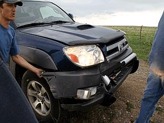
26). May 31, 8:00 PM - Direct penetration extremely severe and tornadic thunderstorm northwest of Lubbock, Texas. This storm was originally an LP supercell that was enhanced by an outflow boundary from stgorms farther north. The storm had a vigourously rotating wall cloud. The storm evolved from LP to a classic supercell, and became HP during occluding cycles. This storm also produced a weak tornado very close to the chase team, then the storm occluded, causing the storm core to be penetrated. The storm contained winds over 70-MPH, torrential rains, frequent lighting, and vigourous golfball-sized hail with isolated baseball sized hail. The chase vehicle, a 2005 Dodge Caravan, was damaged along with the Weatherlab weather station mounted on its roof. The storm was caused by a low-pressure system, upper-level dynamics, an outflow boundary, advancing dryline, and surface heating. Documentation was a camcorder, audio, and still digital photos. A tornado watch was in effect for the area until 9PM MDT. The hail and tornado interception was also reported to the National Weather Service.
This concludes the Midwestern United States Chase Log for the first trip in May 2005. The summary includes a total of 28 severe thunderstorms and 4 tornadoes (or large funnel clouds). The main chase vehicle conducting all chases was a 2005 Dodge Caravan. This information was prepared exclusively for the National Weather service and the team of Skywarn storm spotters.
|
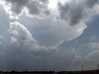
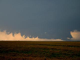
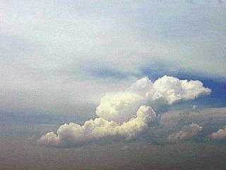
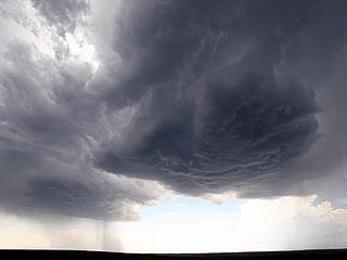
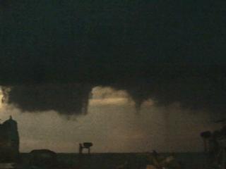
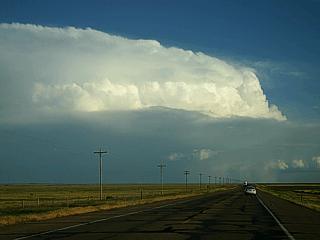
A seemingly benign anvil is an exciting sight when arriving at the chase target area in NW Texas. This storm is a severe thunderstorm "explosively" developing near the dryline west of Quanah, Texas. Note the anvil edge, and smaller towering cumulus (along the dryline boundary) in the far lower right of the picture. The view is towards the west. |
|
The supercell storm splits into two separate storms. Here is the "space" between the split. The original storm split into two parts, a "left mover" and a "right mover", the latter being the interesting storm in this case. The right split is to the far left, the weaker left split is to the far right. |
|
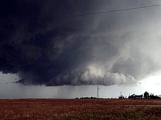
This picture shows a rotating wall cloud on the southwest side of the right moving supercell near Crowell and west of Highway 6. The supercell is in the classic stage at this point. |
|
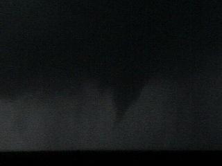
A bit later, the wall cloud is violently rotating, especially to the right, where the wall cloud appears to be on the ground. Other chasers closer to this feature were reporting a tornado on the ground. |
|
Still later, the classic supercell has a large wall cloud with several small funnel clouds near Crowell. Note the dust getting drawn into the updraft to the extreme right of the wall cloud. |
|
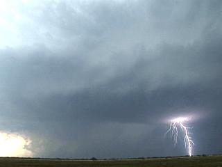
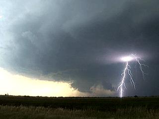
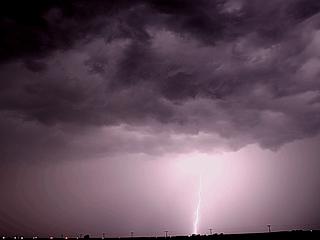
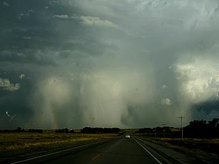
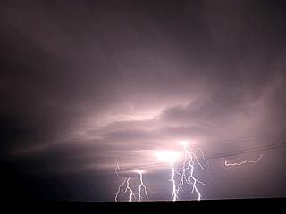
South of Crowell, the classic supercell evolves to HP (rain falling through SW, or rear, flank of the storm). A beautiful CG (Cloud to Ground) lightning strike occurs from this electrically active storm to the lower right. |
|
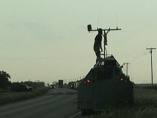
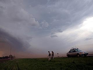
Here is the picture of the TIV (Tornado Intercept Vehicle), which supposedly will be driven THROUGH a tornado to study its interior secrets. It appears to be a heavily armored truck. Note the crowded road full of storm chasers! The driver (standing atop the vehicle) appears to be adjusting equipment, subjecting himself to the dangers of being struck by lightning. |
|
Here is another picture of a beautiful CG lightning strike during the HP evolution of the supercell south of Crowell. |
|
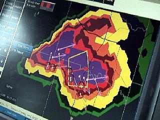
This is XM Satellite Radio (Baron Weather Works) painting an image of the HP supercell just as it was transitioning to a multicell / supercell cluster. The six small red "circles" are regions of rotation, called "shear circles" (mesocyclones) in the storm. Note the "flying eagle" shape and "v notch" in the upper right. XM is an expensive but valuable tool coming to be in the chaser community. |
|
Looking to the north, from south of the HP supercell, the awesome "stacked plates" effect can be seen on the updraft tower of the supercell. This is also called a "barber pole" because of the striations in the cloud tower. |
|
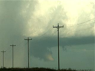
The southwestern end of the storm cluster also contained rotating mesocyclones. This picture shows strong rotation of a weak tornado east of Knox City, Texas taken while seeking refuge from large hail with some locals under a carport. This dusty vortex was rapidly rotating. |
|
Here is another picture of the same rotation, taken from under the carport, just before the storm core obscured its view with 60 MPH winds, heavy rains, and large hail to 1". Note the smaller vortex to the far right, which actually tagged around the main vortex in the center of the picture. This was confirmed as a strong F0 tornado. |
|
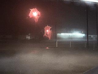
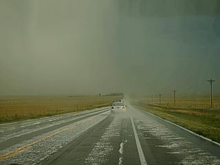
The chase ends in Haskell, Texas along highway 380 after dark. New severe thunderstorms developing behind the main storms dump hail to 1" during a fuel stop at about 9PM. This picture, grabbed from video, shows the hail falling in front of the gas station. |
|
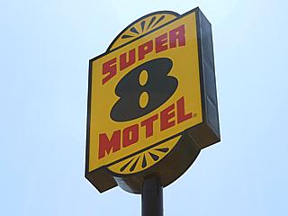
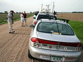
Super-8 Motel, in Witchita Falls, Texas. This sign is a welcomed sight for storm chasers after a long chase. |
|
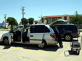
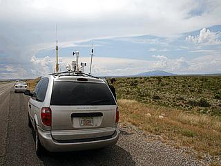
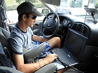
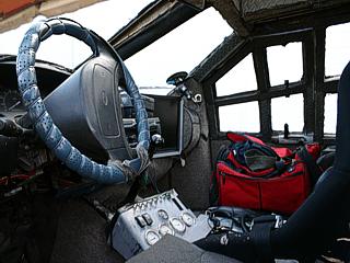
Here is a picture of the equipment being set up atop the chase vehicle, a 2005 Dodge Caravan. The vehicle already has the Weatherlab weather station on its roof, fully functional, and is being loaded with equipment after a long chase day the day before. This day was a "down day", where no storms are being targeted, and is time to prepare for the following chase days, update equipment, and rest. |
|
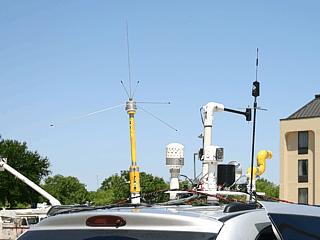
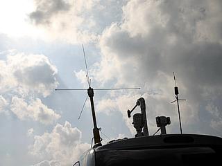
Here is a picture of the Weatherlab weather station atop the Dodge Caravan chase vehicle during "down time" in Witchita Falls, Texas before heading to our "next target" for future chases. |
|
This picture shows the chase vehicle as we are awaiting convective initiation west of Roswell, New Mexico. The storms this day developed from winds blowing up the eastern slope of the rocky mountains, hence the name "upslope". |
|
Here is another picture of the cluster of thunderstorms a couple of hours after initiation. Note the dark base in the center of the picture. |
|
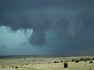
A wall cloud develops on the southwestern side of the most intense thunderstorm in the storm cluster. Weak rotation was noted with this wall cloud. |
|
Here is another picture of a "beaver's tail" that developed on the eastern side of the HP supercell embedded in the storm cluster. This inflow band disappeared as the storms weakened. |
|
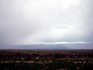
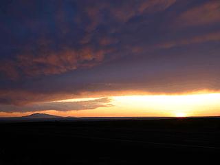
This is a picture of a post-convection sunset northwest of Roswell, New Mexico ending the chase day. |
|
This is a picture of the windmill farms near Montezuma, Kansas. These windmills generate electricity and are funded by FPL Energy. |
|
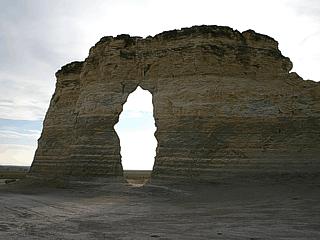
Here is a "natural bridge" formation in the "rock monuments" park south of Oakley, Kansas. These small sandstone buttes are a suprise as they rise out of the Kansas plains. |
|
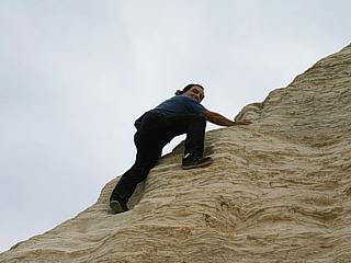
This is a picture of myself doing some rock climbing on one of the sandstone buttes near Oakley, Kansas. |
|
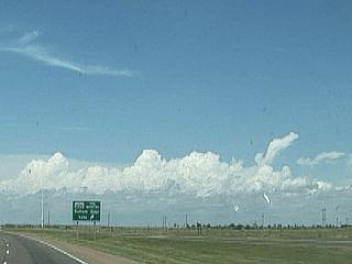
Here is a view of the very first signs of convection northwest of Hoxie, Kansas. This is due to the dryline "punching" out, causing initiation. We are targeting an area north of this region in Nebraska. |
|
This picture shows evidence of a rotating portion of the line segment of thunderstorms as a "clear notch" can be seen in the storm base. This denotes a mesocyclone, and is called an RFD slot (rear-flank downdraft). |
|
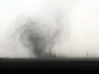
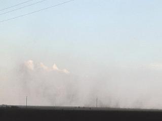
A weak tornado develops beneath a rotating, rain-free base portion of the supercell storm embedded in the line segment of strong and severe thunderstorms. This was about 5 miles south of Cozad, Nebraska. |
|
Here is a closeup of the debris / dust cloud of the tornado south of Cozad, Nebraska. The tornado did not hit any populated areas and was probably in the F0 to F1 range. |
|
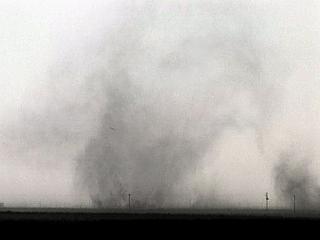
Here is a view to the north in 50-MPH inflow winds east of the supercell thunderstorm on the south end of a line segment of strong and severe thunderstorms. Note the dust being "sucked" into the supercell updraft. |
|
The supercell storm / line segment southern end takes on a majestic "Stacked Plates" effect at sunset. This photo is NOT re-touched despite its striking color. |
|
Here is a picture of ourselves and other storm chasers waiting for initiation in Emporia, Kansas. The cumulus developing in the sky is the first sign severe thunderstorms will eventually develop. Surface heating by the sun causes the cap (warm air aloft) to "break" (be overcome by convection) by late afternoon. |
|
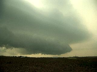
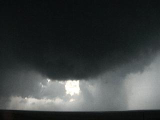
Here is a picture of an HP supercell southeast of Topeka, Kansas looking northward towards the area of circulation. Note the low wall cloud (center) and RFD area to the left. The green "glow" is caused by large hail to the right. |
|
This picture shows another view of the same HP supercell southeast of Topeka looking towards the west. The RFD gust front is to the right side of the picture. Note the CG lightning strike in the distance (center). |
|
Here is a picture taken south of Burlington, Kansas of a shelf cloud of a post-supercell multicell cluster of severe thunderstorms. Only lightning was used to produce the lightning for this storm in this picture. |
|
This is a picture of a few CG (Cloud to Ground) lightning strikes southwest of Burlington, Kansas on the southwestern side of a severe thunderstorm cluster. |
|
Here is a picture of a CC (Cloud to Cloud) lightning strike firing through the anvil region of a severe thunderstorm cluster north of Chenute, Kansas. These anvil "crawlers" are also called "dendrite" lightning. Note the shelf cloud in the lower part of the picture. |
|
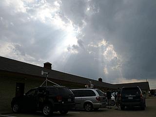
Jeff Gammons mundanely checks surface data in front of a hotel in Tulsa, Oklahoma as chase prospects for the day begin to become discouraging. |
|
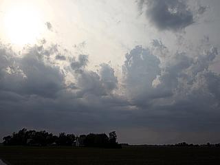
Here is a view of the sky above the chase team at 6 PM in Tulsa, Oklahoma. A warm air inversion aloft called a "cap" prevents convection despite favorable shear and instability. This is called a "bust" ... Storms never developed, giving the chase team a suntan instead! |
|
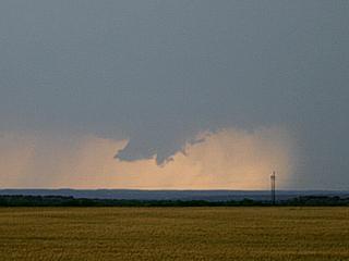
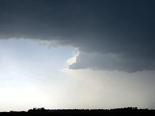
This is a picture of a weakening LP supercell storm in south central South Dakota near the Missouri River from about 45 miles away. The storm here has evolved to an elevated storm with a very high base (over 10,000 feet) and low top (about 35,000 feet high). |
|
Waiting for initiation in Norfolk, Nebraska during a data-stop at about 3 PM. In this picture, we are already in our "target area", where storm development is most expected based on our forecasts. |
|
Here is our group of chasers as well as others including Tony Laubach, Eric Nguyen, and Scott Currens waiting and waiting for storms to fire in an extremely unstable airmass. Well, once again, the setup went to waste as a warm layer of air at 10,000 feet "capped" the atmosphere preventing initiation. Here the chasers are fearing another imminent "bust". |
|
This is the closest we ever got to having storms. The enhanced cumulus seen here never had enough energy to overcome the capping inversion of warm air aloft (mid levels). Note the drying and flattening out of the cloud tops. "Busted" once more. |
|
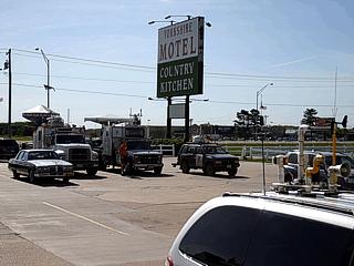
This is the front of the Yorkshire Motel in York, Nebraska on the morning of May 22. This was after the big "bust" a day earlier and before a better future setup for storms. In this picture, we can see the two DOW (Doppler On Wheels) vehicles as well as other chase vehicles in the parking lot for the stay of nearly 30 storm chasers the night before. |
|
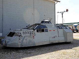
Here is a picture of the TIV (Tornado Intercept Vehicle) parked behind the Yorkshire Motel in York, Nebraska. This vehicle is designed to "core punch" a moderate tornado's corner region (where it contacts the ground). The armor is mainly for debris protection. |
|
This is a picture of the cockpit of the TIV, or tornado intercept vehicle, taken through a small hatch in the driver's side of the vehicle. |
|
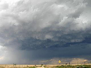
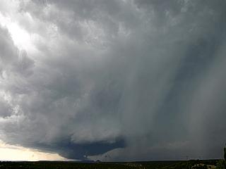
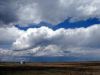
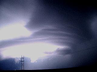
Here is a picture of elevated severe thunderstorms developing over Northwestern Nebraska, Northeastern Colorado, and Southeastern Wyoming. These high based storms look benign, but are excellent hail producers. |
|
This picture shows the rain-free base of the elevated severe thunderstorms developing over Kimball, Nebraska. Note the sun light on the falling hail shaft in the lower right. |
|
Looking eastward, after the storms passed by, a beautiful view of the falling hail and back side of the elevated severe storms can be observed. This storm produced pea to dime sized hail near Bushnell. Note the light hail "streaks". |
|
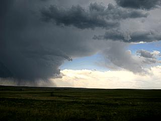
This is a rapidly developing elevated thunderstorm over extreme northeastern Colorado. |
|
Here is another view of the same small storm as it reached its mature stage. These storms are so called "elevated" because they are fed by moisture ABOVE a dry layer at the surface in an unstable air aloft setup. |
|
This is a missile silo along the side of the road we were chasing on. Minutes after I took this picture two military officers in a blue SUV drove up and politely asked us to leavel saying "It is not good to be driving on this road". This is most likely one of many such combat-ready LGM-30 Minuteman launch facilities near F. E. Warren Air Force Base under the 90th Missile Wing. |
|
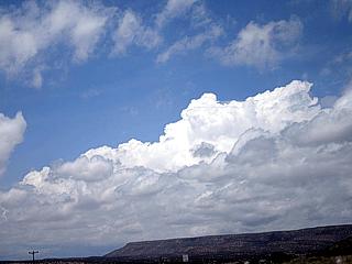
Some mammatus clouds on the underside of a dissapating thunderstorm over Colorado as the sun begins to set. |
|
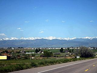
This is the view, in mid May, of the front range looming over the outskirts of Boulder, Colorado. Note that the highest peaks are still snow-capped. |
|
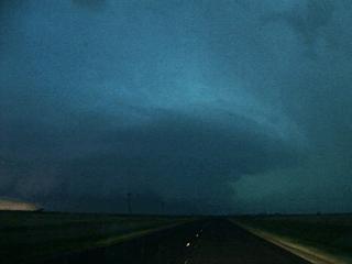
An LP supercell southwest of Limon, Colorado starts another chase for this day. The view is to the southwest. Note the vault region of the storm developing. If you look very hard in the lower right portion of the picture, you can see Pike's Peak. |
|
This is the updraft side of the LP supercell with some beautiful structure in the rain-free base. The view is to the north. |
|
As the LP supercell's mesocyclone strengthens and tightens, the rain-free base acquires a rounded appearance. Note the precipitation (hail) wrapping around the circulation. |
|
Here is a picture of a CG lightning bolt through the weakening LP storm as it reached Kit Carson, Colorado. |
|
This picture is a close-up of an overshooting top of a supercell thunderstorm over Springfield, Colorado taken from near Kit Carson (about 100 miles away). This "dome" can reach 60,000 feet, or more! |
|
Cloud to Ground (CG) lightning in a severe thunderstorm west of Goodwell, Kansas. |
|
Convective initiation near Last Chance, Colorado. This developing cumulonimbus in this picture will eventually become an LP supercell thunderstorm. |
|
Here is a picture of an LP supercell (right) with its rain-free base northwest of Last Chance, Colorado. This main storm is rotating counter-clockwise (cyclonic). Note the other supercell to the left, this one is rotating clockwise (anticyclonic), and is a left-split from a storm complex to the southwest. These two cells eventually merged together and weakened as two supercells in close proximity will "fight" for the same inflow and moisture. |
|
Here is a picture of a large, rotating wall cloud near Kirk, Colorado before becoming rain-wrapped. This wall cloud is part of a supercell quickly evolving from classic (shown here) to HP, then weakening as the RFD and inflow occludes. |
|
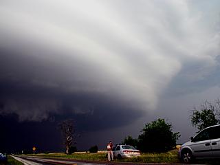
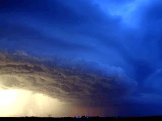
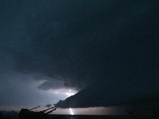
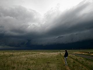
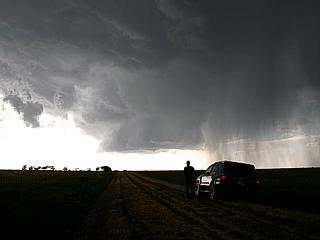
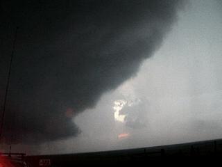
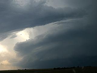
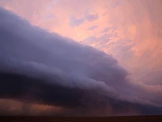
A violent HP (high precipitation) supercell makes a menacing appearence over highway 96 near Towner, Colorado. These storms contain extremely large hail and can produce large tornadoes that are hard to see as they are often wrapped in precipitation. In this twilight image, the tornado region, or "bear's cage" is in the center of the picture (the road goes right to it). Note the hail-filled (green glow) vault to the right and RFD gust front and dark precipitation to the left. |
|
Taken from the "entrance" to the "bear's cage", here is a view to the south-southeast at the inflow tail (beaver's tail) issuing INTO the HP supercell storm (to the right). The clouds in this tail raced from left to right. Winds were about 60-MPH from the northeast at the location this picture was taken. A bright CG (Cloud to Ground) lightning strike even blasts through part of the inflow tail. |
|
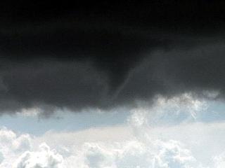
The same HP supercell storm spawns a funnel cloud on the inflow band and eastern side of the wall cloud. This picture was teken from the same location as the picture above. |
|
The HP supercell west of Tribune, Kansas and near Towner, Colorado occludes, that is, the RFD gust front cuts-off the storms main inflow. When this happens, the storm becomes outflow dominant, and evolves to a bow-segment of damaging straight-line winds. The gust front in this picture was taken by lightning illumination. Note three things besides the storm: The car passing on the road to the left, the lights of the chase vehicle to the right, and airplane lights in the sky ahead of the shelf cloud (there were three planes, one most likely a WP3 Orion weather research aircraft)! |
|
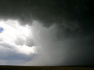
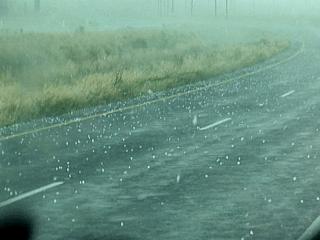
Here is a picture of the bow-segment of the storm blasting through Syracuse, Kansas on Highway 50 just east of Highway 29. Violent rain and marble-sized hail are blasted by straight-line winds approaching 100-MPH. |
|
This picture shows the view to the north near Raton, New Mexico of a portion of the front range south of Trinidad, Colorado. The cool and moist post-frontal air (from the north and northeast) forms a mountain-obscuring upslope cloud which disappears south of the mountains creating what is called a "foehn gap". In this gap, crystal clear sinking air clears out the low clouds near the mountains. Note the anvil from a thunderstorm south of the area high above. |
|
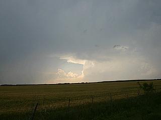
Convective initiation taking place south of a cold front in the unstable air of the warm sector while looking south along Interstate 25 north of Springer, New Mexico and south of Raton. |
|
Here is a picture of an LP supercell storm before weakening southwest of Springer, New Mexico. Note the hail streaks "wrapping" from left to right around the updraft. |
|
This is an incredible picture of what is called "explosive convection"! This storm is developing along a cold front under strong wind shear conditions in high instabilities. The storm went from small cumulus to this in under 30 minutes, and became a supercell storm northeast of Springer, New Mexico. You could see this roiling and moving UP with your bare eyes! |
|
Here is a picture of another explosively developing supercell storm near Tecumcari, New Mexico. This storm also fired along the cold front in the area and evolved into a violent supercell that passed near Logan, New Mexico. Note the extreme tilting of the updraft due to the directional and speed shear in the atmosphere. |
|
This is a picture of the inflow bands into a supercell thunderstorm (right side of the picture) north of Logan, New Mexico. Note the cloud to cloud (CC) lightning strike illuminating the storm. Note the banding of the storm updraft. |
|
Here is a view of the UDI (updraft-downdraft region) of a supercell storm northwest of Logan, New Mexico, from within the "bear's cage" just prior to a core punch to sample giant hail. The falling precipitation to the right is hail up to baseball sized and produced a distinct and loud audible hail roar. Core punching is extremely dangerous, and is being done here on a non-tornadic supercell in a specially modified vehicle (Scott Blair - KD5KOW). |
|
Giant hail (blurred white streaks) falls northwest of Logan, New Mexico during a supercell core punch in Scott Blair's (KD5KOW) chase vehicle. Hail exceeding two inches (almost as big as baseballs) was encountered in this supercell core. |

|
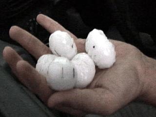
This picture shows Scott Blair holding large hail, after it melted considerably after sampling the hail core of a supercell storm northwest of Logan, New Mexico. |
|
This is a picture of marble to quarter sized hail covering the parking lot of a gas station in Logan, New Mexico. The hail sizes here were MUCH smaller than earlier. |
|
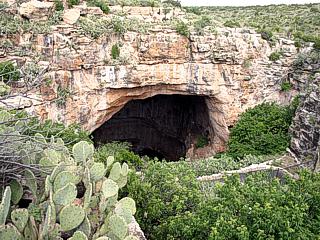
This is a picture of the natural entrance to Carlesbad Caverns in New Mexico. During any down time, this area is a favorite place for storm chasers to visit. |
|
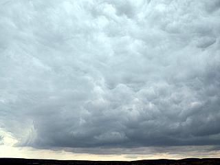
Here is a strange picture of some turbulent clouds over Carlesbad, New Mexico during a down day where barely marginal conditions existed for good storms. This cloud in this picture is marked by turbulence and even has an updraft base to some extent. |
|
Convective initiation marks the start of another exciting chase day near Las Vegas, New Mexico. The cumulus here will soon grow into a full-fledged supercell thunderstorm. |
|
This is a picture of a classic supercell southeast of Las Vegas, New Mexico during its intensifying stage (after evolving from LP to classic). Note the rain free base and "barber pole" updraft developing. To the right is the hail core, that is the greenish colored streaks. This storm was a prolific hail producer. |
|
Here is another picture of the supercell southeast of Las Vegas during its classic stage. A funnel cloud can be seen in the lower-left portion of the cloud base. Note the bright lightning bolt to the right in the hail core. |
|
This is a very suspicious picture. It appears to be a large wall cloud (or large tornado?) northwest of Interstate 40. The view is into the "notch" area of the HP supercell storm (inflow area between the RFD to the left and forward-flank gust front to the right). |
|
Here is another view of the HP supercell notch and wall cloud area. A large funnel cloud appears on the wall cloud. Note the inflow jet and dust in the lower-right side of the picture. |
|
This is a picture of the core of the supercell as it crosses Interstate 40 from Scott Blair's (KD5KOW) chase vehicle. 70-MPH winds and golfball sized hail fall so hard the entire roadway becomes accumulated with ice as in a snowstorm. |
|
Here is a view out the front windshield of Scott Blair's chase vehicle (note the cracks in it). The hail covers the highway several inches deep like snow. |
|
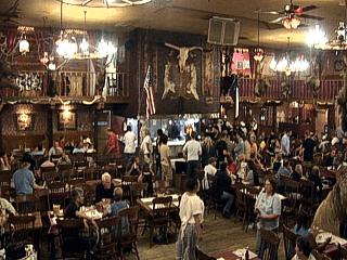
Nothing like wrapping up a busy chase day at the Big Texan steakhouse in Amarillo, Texas after a long drive from New Mexico. There are actually three people sitting in the center of the picture with a crowd around them. They must eat a FREE 72 Oz steak with all side trimmings in one hour or less ... If not, you BUY it. Two of the three won! |
|
Convective initiation taking place in our target area for the day near Kit Carson, Colorado. This distant storm is developing and will soon become a supercell storm southeast of Burlington. Note the towering cumulus in the foreground being toppled over by the speed and directional shear. |
|
During the highpoint of the Burlington supercell, an RFD (Rear Flank Downdraft) creates a clear "slot" in the storm base (to the left). The area to the right is the wall cloud and focus of rotation within the mesocyclone. This storm came very close to producing a tornado. |
|
A second and much more majestic supercell develops near Springfield, Colorado at the end of a line of thunderstorms. The view here is looking south out of Lamar, Colorado, nearly 50 miles away. |
|
The Springfield storm, like many Colorado supercells, was a prolific hail producer. The white and green hail shafts are unmistakable with this storm. In this picture, at least three major hail shafts cross the picture from left to right. |
|
The Springfield supercell spawns a tilted funnel cloud on its rain-free rear-flank side just to the right of the hail core looking south. |
|
Marble to 1" hail covers the roadway as the "hail swath" is crossed behind the storm. |
|
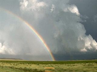
A rainbow, or more likely, a "hailbow" can be seen in this picture as we finally penetrate the rear-flank (hook) precipitation. The "green glow" can be seen in this picture as the low afternoon sun angle refracts through the hail-laden precipitation. The view here is to the east. |
|
Here is another picture of the hail shaft with lightning viewed from the southeast side of the storm looking northwest. |
|
Here is a picture of myself in the foreground with lightning and the supercell structure in the background while documenting the Springfield supercell after dark. |
|
This is a brilliant cloud to ground (CG) forked lightning strike from the Springfield, Colorado supercell. |
|
Here is another picture with a longer exposure capturing incredible multiple cloud to ground lightning strikes with some of the supercell structure illuminated by the lightning bolts. |
|
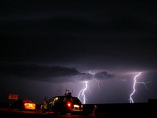
This picture shows two cloud to ground lightning strikes with our chase vehicles in the foreground. |
|
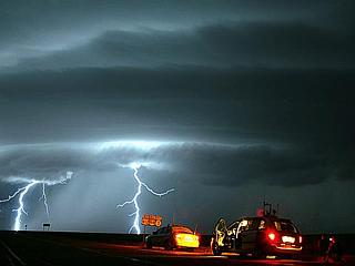
Here is a picture of the mesocyclone (note the striations) and vault-region (right) illuminated by lightning (very bright). Note the "stacked-plate" or "barber pole" appearance of the supercell updraft. The RFD gust front shelf-cloud is the band extending to the left. Also note the wall cloud in the lower right to center of the picture. |
|
Another round of impressive structure and lightning wraps up this chase day on the supercell after it was followed from near Springfield, Colorado into the central Oklahoma panhandle. The two vehicles are Scott Blair's (KD5KOW) Ford Taurus to the left and the "Weathervine" rental vehicle to the right. |
|
This is a picture of convective initiation taking place in the forecasted target area northwest of Mosquero, New Mexico. A developing supercell thunderstorm can be seen to the right of this picture. |
|
A spectacular shelf cloud marks the violent "gusting out" stage of the short-lived supercell near Abbott, New Mexico. This gust front dropped the temperature 20 degrees with outflow winds over 50-MPH. Note the wall cloud to the extreme far left. |
|
The supercell thunderstorm produces this large wall cloud before its updfraft is undercut by the gust front and outflow. This wall cloud was rotating and even spawned some small funnels. |
|
This is a picture of one of many cloud to ground lightning strikes produced by the outflow dominant Abbott, New Mexico storm. The lower base in the extreme left portion of the picture is a weakening LP storm about to get undercut by the gust front. The shelf cloud of the gust front is in the center of the picture just right of the lightning bolt. |
|
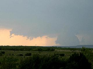
Here is a picture of another supercell near Trinidad, Colorado from about 50 miles away. This was the second supercell observed this day. |
|
Marble sized hail covers the ground east of Trinidad, Colorado along Highway 160. The hail was from the same supercell storm pictured earlier over Trinidad. Note the hail "fog" above the horizon. The scene looks more like winter, and even felt like it as the thunderstorm cold air dropped the temperature from the mid 70's to the mid 40's! |
|
Flash flooding from the Trinidad supercell occurring along Highway 160 east of Trinidad, Colorado. This rising water was both runoff from heavy rains as well as melting hail. |
|
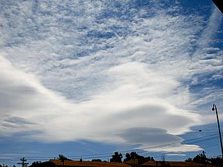
Lenticular clouds stream over Trinidad, Colorado during the start of a chase day full of supercells east of the area. These clouds are caused by strong winds interacting with mountains. |
|
This wall cloud pictured here developed on the second supercell to form east of Trinidad, Colorado south of Highway 160. This wall cloud was rapidly rotating, but the parent supercell weakened too quickly to produce any tornadoes. |
|
Here is a scary picture of the results of hitting a deer that dashed out in front of Amos Magliocco's vehicle and struck the right front side. Amos was not hurt in the accident. The deer was killed instantlty and did about $5,000 worth of damage to the vehicle. |
|
Here is a picture of a supercell thunderstorm north of Branson, Colorado south of Highway 160. Note the vault region to the right and funnel in the very center of the wall cloud. |
|
A persistant funnel appears on the center of the wall cloud of the supercell storm north of Branson. |
|
A dramatic rainbow appears on the western side of a developing supercell near Kim, Colorado as it is viewed from the west (view is to the east). This storm was the storm that subsequently will produce a tornado. |
|
This is a spectacular picture of the north side of the supercell mesocyclone called the "vault region", visually denoting a dramatic BWER (Bounded Weak-Echo Region). This feature is loaded with giant hail. The rotating component of the storm updraft column is the the left. |
|
Here is a picture of some of the golfball-sized hail, or larger, found along the side of the road near the supercell vault region of the storm. |
|
Here is a picture of the violently rotating bowl-shaped lowering in the wall cloud as the storm mesocyclone tightens up. |
|
A brief tornado appears just before becoming rain-wrapped under the wall cloud of the supercell storm. |
|
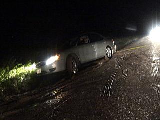
Here is a picture of Jason Persoff's vehicle being pulled out of a ditch he skidded into during our storm chase. Luckily, one of the chasers caravaning with us had a tow rope, and pulled him out (note the rope to the upper right). Lesson learned - The "buddy system" works! |
|
Here is a picture of towering cumulus during convective initiation beginning near and west of Plainview, Texas. |
|
This is a picture of a late-stage occluding and formerly tornadic HP (High Precipitation) supercell west of Plainview, Texas. Note the "stacked plates" effect (striations) in the mesocyclone. |
|
An extremely low wall cloud develops on a classic supercell evolving to HP well northwest of Lubbock, Texas from a supercell that originated over Clovis, New Mexico and moved into Texas. |
|
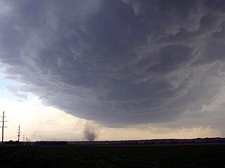
Looking directly overhead, in the EXTREMELY DANGEROUS area of the rain and hail-wrapped "bear's cage", the funnel of a developing tornado appears as a rotating disk in the wall cloud. |
|
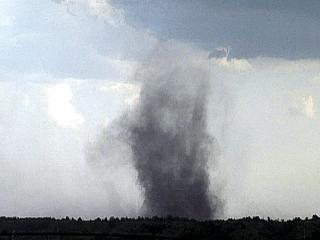
A spinup on the ground denotes ground contact with the tornadic circulation. The dark objects are tumbleweeds swirling around in the touchdown area. |
|
Here is a picture of golfball-sized hail falling as the core of the supercell closes around the chase vehicle after being in the "bear's cage" of the storm. Winds here are also gusting over 70-MPH. |
|
A spectacular gust front blasts southeastwards after the supercell becomes outflow dominant east of Lubbock, Texas. Dust kicked up by the outflow creates a "haboob" effect. Note the tiers of the shelf cloud. |
|
Today was a long trip driving back home. This is a picture of an elevated stretch of Interstate 10 headed east through Louisiana over the Bayou swamp. |
| CHASER NAME | HOME CITY | CALLSIGN | CHASE DATES | OCCUPATION |
| CHRIS COLLURA | MIRAMAR, FL | KG4PJN | 6-9 TO 6-13 | IT CONSULTANT |
The participants below often actively participate in our storm research efforts and deserve appreciation for their great help and severe weather expertise. Some of these chasers may have also caravaned with my group at some point in the trip.
| CHASER NAME | HOME CITY | CALLSIGN | OCCUPATION |
| AMOS MAGLIOCCO | BLOOMINGTON, IN | KC5VPD | WRITER |
| ERIC NGUYEN | NORMAN, OK | KD5HPZ | METEOROLOGIST |
| SCOTT BLAIR | FORT SMITH, AR | KD5KOW | METEOROLOGIST |
| SCOTT CURRENS | NORMAN, OK | KE5AIV | STUDENT |
| STEPHEN MILLER | MCKINNEY, TX | KD5FMI | COMPUTER PROGRAMMER |
June 9 - Arrival day. This was not a chase day as I arrived into Dallas Fort Worth (DFW) airport late evening, made car rental arrangements, and found accomodations in Dallas for the evening. The next day was to be a chase day in Oklahoma / Texas.
June 10 - Chase day. This day had some good and bad points. The good point was lots of shear and boundaries, the bad thing was instability (based on timing of the disturbances). Today involved forecasting very early, leaving Dallas, Texas, then picking a target of Woodward, Oklahoma. Once in Woodward, it appeared convection was developing very early in the day and was not very organized. Some severe thunderstorm clusters were found near Wheeler, Texas then later near Amarillo, Texas. One storm west of Amarillo briefly became supercellular, with a rotating wall cloud. The day ended with a drive back to Oklahoma City from Amarillo to visit friends and spend the night.
June 11 - Today was a better chase day around and south of the Amarillo, Texas area once again. I left Oklahoma City and headed back towards Amarillo, Texas, then south towards Happy, Texas on Interstate 27. After meeting up with Stephen Miller (KD5FMI), Scott Blair (KD5KOW), Amos Magliocco (KC5VPD), Scott Currens (KE5AIV), and Eric Nguyen (KD5HPZ) near Hereford, Texas, we headed for a storm that fired west of Amarillo. The storm became supercellular with rotating wall clouds and funnels before being cut off by a tornadic storm to the south. Stephen Miller and I observed the storm for some time as it came close to producing a tornado. The storm to the south produced some small tornadoes as observed by Amos Magliocco, Scott Blair, Scott Currens, and Eric Nguyen. Steve and I were too late for that storm as severe flash flooding was encountered southeast of Amarillo after all storms evolved to multicell clusters. The night was spend with Stephen Miller and myself in Canyon, Texas. The big day was to be the next and final chase day.
June 12 - BIG chase day. Today was a day many chasers dream about, with a violent cyclic supercell producing just about every type of tornado you can have! Stephen Miller and I forecasted and left Canyon, Texas for the area near and east of Plainview. The setup was complicated by boundaries, but had great shear, instability, and a dryline bulge. First storms developed southeast of Hereford, briefly becoming supercells, but then coming off the boundary and weakening. Another supercell, farther south and more "anchored" on the boundary, rapidly developed as Stephen and I raced towards it west of Spur, Texas. This supercell produced at least EIGHT (yes, 8) tornadoes over nearly a two hour period, including ropes, elephant-trunk, cone, stovepipe, multiple-vortex, and wedge variants! Unfortunately, the multi-vortex tornado did do some damage near the Spur, Texas area. This storm was the high-point of my tornado chasing career. After this storm weakened, another supercell developed to its south west of Aspermont, Texas. This storm was also violent, and rotated hard with its wall cloud, but only came to produce a funnel or two. Stephen Miller and I ended this day with dinner in Stamford, Texas before he headed back to Mc Kinney and myself for the DFW area. Got stopped in Weatherford, Texas for speed trap (80 in 65) on Interstate 20, then proceded back to Dallas for the evening.
June 13 - Travel day. Today was a travel day where the rental vehicle was returned at about 3 PM and my flight back to Orlando, Florida was 5:50 PM. I did manage to check out the Six Flags park in the morning. All and all, except for the speeding, this trip was one to remember! This concludes the SECOND trip for chase expedition 2005 (June).
1). June 10, 1:00 PM - Interception and penetration of a severe thunderstorm north of Wheeler, Texas along Highway 83. The storm was part of a multicell cluster of strong and severe thunderstorms. Frequent lightning, very heavy rains, dime-sized hail (1/2"), and 60-MPH winds were encountered with this storm. The storm was caused by surface heating, an upper-level disturbance, surface low-pressure, and outflow boundaries. A 2005 Chevy Corsica was used to chase the storms. Documentation was a camcorder. A tornado watch was in effect for the area until 6 PM CDT.
2). June 10, 5:00 PM - Interception and penetration of a severe thunderstorm north of Amarillo, Texas near Highway 87. The storm was also part a multicell cluster / line of strong and severe thunderstorms. Frequent lightning, very heavy rains, hail up to nickel-sized (3/4"), and 55-MPH winds were encountered with this storm. The storm was caused by surface heating, an upper-level disturbance, surface low-pressure, and outflow boundaries. A 2005 Chevy Corsica was used to chase the storms. Documentation was a camcorder. A tornado watch was in effect for the area until 6 PM CDT.
3). June 10, 6:00 PM - Observation of a severe thunderstorm west of Amarillo, Texas just south of Interstate 40. The storm was a small supercell storm that developed a rotating wall cloud before weakening as outflow from storms to its northeast undercut it. Frequent lightning, heavy rains, funnel clouds, and 40-MPH winds were encountered with this storm, although its core was not penetrated. The storm was caused by surface heating, an upper-level disturbance, surface low-pressure, dryline, and outflow boundaries. A 2005 Chevy Corsica was used to chase the storms. Documentation was a camcorder. A tornado watch was in effect for the area until 6 PM CDT.
4). June 11, 5:00 PM - Observation of a very severe thunderstorm west of Amarillo, Texas just north of Interstate 40. The storm was a classic supercell storm that developed many wall clouds, some with violent rotation and funnels, and occluded several times before weakening as storms developed to its south. Inflow winds up to 40-MPH and frequent lightning were encountered with this storm before it became linear and outflow dominant. Its core was not penetrated. The storm was caused by surface heating, an upper-level disturbance, surface low-pressure, and dryline / boundary interactions. A 2005 Chevy Corsica was used to chase the storms. Documentation was a camcorder and digital still photos. A tornado watch was also in effect for the area until 9 PM CDT.
5). June 11, 7:00 PM - Observation and indirect penetration of a severe thunderstorm west of Vega, Texas near Interstate 40. The storm was an HP supercell that was tornado-warned but weakened when we got to it. The storm produced winds up to about 45-MPH, heavy rains, frequent lightning, and dime to nickel-szed hail. The storm also became outflow dominant with a dramatic shelf-cloud associated with its gust front on the southeast side of the storm. The storm was caused by surface heating, an upper-level disturbance, surface low-pressure, and dryline / boundary interactions. A 2005 Chevy Corsica was used to chase the storms. Documentation was a camcorder and digital still photos. A tornado watch was also in effect for the area until 9 PM CDT.
6). June 11, 9:00 PM - Observation of a severe thunderstorm east of Happy, Texas east of Interstate 27. The storm was another supercell storm but did not really do much, neither were we able to get to it as farm-road 1881 was closed due to an overturned sheriff vehicle and flash flooding problems. The storm was not penetrated or reached, but a low wall cloud was observed with it. The storm was caused by surface heating, an upper-level disturbance, surface low-pressure, and outflow boundary interactions. A 2005 Chevy Corsica was used to chase the storms. Documentation was a camcorder and digital still photos. A tornado watch was also in effect for the area until 9 PM CDT.
7). June 11, 10:00 PM - Observation and encounter with another severe thunderstorm in Canyon, Texas. This severe thunderstorm was part of a multicell cluster or severe thunderstorms. Heavy rains, vivid and frequent lightning, 50-MPH winds, and nickel-sized (3/4") hail was observed as the storm passed over the motel in Canyon. The storm was caused by surface heating, an upper-level disturbance, surface low-pressure, and outflow boundary interactions. A 2005 Chevy Corsica was used to chase the storms. Documentation was a camcorder and digital still photos. A severe thunderstorm watch was also in effect for the area until 5 AM CDT.
8). June 12, 4:00 PM - Observation of a small severe thunderstorm southeast of Hereford, Texas. This storm was a small supercell storm that developed ahead of the dryline near a boundary. The storm produced a wall cloud and funnel, but weakened as it came off the boundary. This storm later did intensify briefly and produce a small tornado / funnel (not observed) until a new supercell storm developed south of it. The storm was caused by surface heating, an upper-level disturbance, surface low-pressure, and dryline / boundary interactions. A 2005 Chevy Corsica was used to chase the storms. Documentation was a camcorder and digital still photos. A tornado watch was also in effect for the area until 8 PM CDT.
9). June 12, 6:00 PM - Observation of an extremely severe, dangerous, and tornadic thunderstorm near Spur, Texas. This storm was a cyclic supercell (mostly classic by nature) that became a prolific tornado producer. The storm quickly exploded near Crosbyton, Texas and moved eastwards with a large rotating wall cloud. The storm produced two tornadoes during its first cycle, one a large "stove-pipe" / "elephant trunk" tornado. The storm cycled again farther southeast and produced both a large "cone" tornado and when a "wedge". The storm then cycled again and produced a multiple-vortex tornado (or tornadoes) close to Spur, Texas, with airborne debris visible. The storm occluded and cycled again while maintaining a long-lived "stove-pipe" that slowly evolved to an "elephant trunk" tornado visible through the RFD precipitation AFTER the mesocyclone occluded. The storm also produced 70 to 80-MPH+ RFD winds, inflow winds to 60-MPH, golfball sized hail (we did NOT penetrate the core of this storm), heavy rains, and frequent lightning with many close hits in the same place less than a second apart! A loud hail roar was also noted with this storm as well as a "train sound" from the tornadoes. At one point, this storm appeared as an "upside-down wedding cake" visually. The storm weakened after its inflow was cutoff by another supercell south of it. The storm was caused by surface heating, an upper-level disturbance, surface low-pressure, and dryline / boundary interactions. A 2005 Chevy Corsica was used to chase the storms. Documentation was a camcorder and digital still photos. A tornado watch was also in effect for the area until 8 PM CDT.
10). June 12, 8:00 PM - Observation of another very severe thunderstorm southwest of Aspermont, Texas. This storm was a supercell storm which produced a rapidly rotating wall cloud and funnels. The storm was south of the better jet-stream dynamics / shear in place for the former tornadic storm near Spur and Crosbyton. The core of this storm was not penetrated, but isolated quarter to golfball sized hail was falling out of the storm anvil ahead of the inflow notch. Frequent lightning with close hits, and 40-MPH inflow winds were also encountered with this storm. Visually, the storm had a "stacked-plates" appearance. The storm was caused by surface heating, an upper-level disturbance, surface low-pressure, and dryline / boundary interactions. A 2005 Chevy Corsica was used to chase the storms. Documentation was a camcorder and digital still photos. A tornado watch was also in effect for the area until 8 PM CDT.
This concludes the Midwestern United States Chase Log for the second trip in June 2005. The summary includes a total of 10 severe thunderstorms and at least 8 tornadoes (or large funnel clouds). The main chase vehicle conducting all chases was a 2005 Chevy Corsica. This information was prepared exclusively for the National Weather service and the team of Skywarn storm spotters.
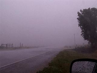
|
This is a picture of one of the first storms penetrated on this chase trip. This is the passage of a severe thunderstorm cluster with wind gusts over 60-MPH and heavy rain north of Wheeler, Texas while looking south along Highway 83. |
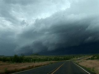
|
Here is a picture of the southeastern side of an outflow-dominant severe thunderstorm cluster northwest of Amarillo, Texas. This storm packed winds over 60-MPH and large hail. |
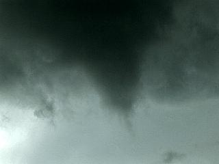
|
A small funnel cloud develops under the shelf cloud of the gust front in the storms northwest of Amarillo, Texas. This funnel was probably associated with a gustnado along the outflow side of the storm. |
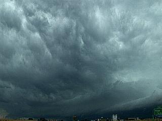
|
This is a picture looking west along Interstate 40 west of Amarillo, Texas. Note the mammatus looking clouds in the high foreground of the picture denoting severe turbulence aloft. The developing storm being targeted is at the extreme lower-left side of the picture, and is a "tail-end charley" storm developing near the dryline boundary to the west. |
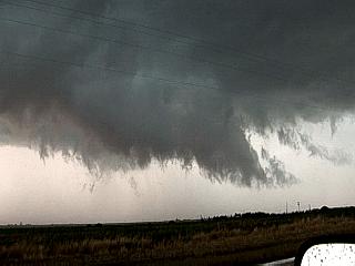
|
A wall cloud develops on a supercell thunderstorm west of Amarillo, Texas just south of Interstate 40 with slight rotation. |
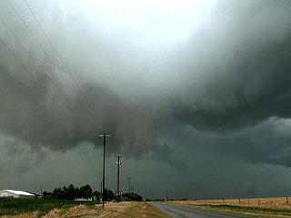
|
The same supercell west of Amarillo, Texas spins up rotation and a small funnel cloud on its wall cloud. Note the RFD clear slot coming in the high foreground looking north at the mesocyclone. This storm became undercut from outflow from storms farther north and eventually weakened. |
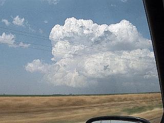
|
Convective initiation in out forecasted target area north of Hereford, Texas begins the chase. In this picture, a developing supercell looms northeast of us as it develops along a boundary / dryline intersection. |
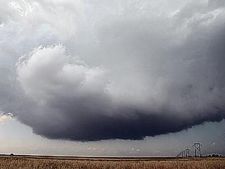
|
A large "bowl-shaped" lowering appears on a developing supercell storm west of Amarillo, Texas. This is just when the supercell has developed a mesocyclone (broad rotation). |
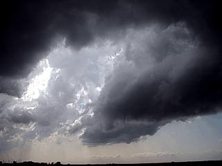
|
The supercell near Amarillo, Texas draws in drier air in its Rear Flank Downdraft, or RFD, and creates a "clear air slot" (called an RFD dry slot) into the backside of the supercell. Note the clear area to the left portion of the picture. The mesocyclone core is to the right of the photo. |
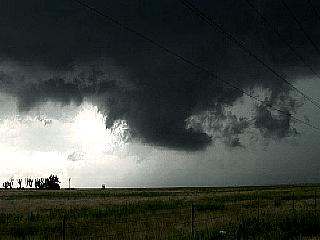
|
A rotating wall cloud develops on the southwest side of the same supercell near Amarillo, Texas as tornado sirens blair. |
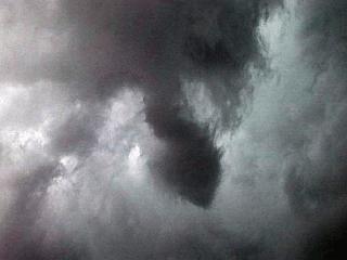
|
The supercell storm near Amarillo, Texas did not produce full-fledged tornadoes as another batch of supercells developed to its south. It did produce many rapidly rotating funnels, like the one pictured here. |
|
Here is a picture of an Allsups convenience store during a quick fuel stop. The pumps worked (via credit / debit card) but no one was to be seen in the store. Note the sign on the door saying "Closed - Take Cover"! This was near Vega, Texas in the path of a tornado-warned supercell that fortunately weakened before hitting Vega. |
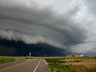
|
As storms become outflow dominant, a dramatic shelf cloud and gust front appears southeast of a weakening supercell storm. The storm in this picture, however, was still producing violent winds and hail. |

|
A funnel cloud, or even a possible tornado, appears on the backside (southwest side) of an HP (high precipitation) supercell storm departing the farming areas east of Happy, Texas. This storm, in addition to tornadoes, dropped about 8 inches of rain in only an hours time. |
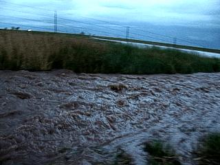
|
Flash flooding occurred with the passage of the supercell storms, especially in the farming areas east of Happy, Texas. In this picture, a torrent of running water flows by the side of a farm road. |
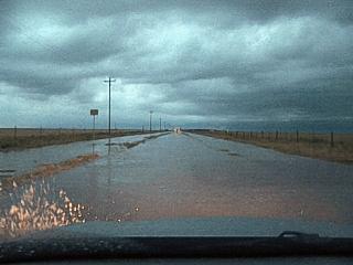
|
Many farm roads east of Happy, Texas became flooded with deep, muddy water making travel through the area nearly impossible. What looks like a canal is supposed to be a paved farm road. |
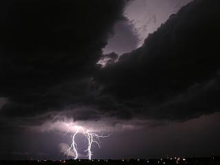
|
Here is a picture of some CG (Cloud to Ground) lightning west of Canyon, Texas during a developing severe thunderstorms. Note the inflow bands in the top of the picture. |
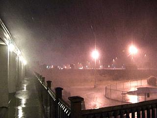
|
The same storm eventally moves through Canyon, Texas and hits the motel with 60-MPH winds and hail up to marble-sized. |
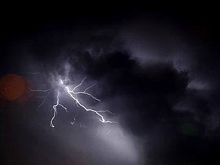
|
Here is a picture of CC (Cloud to Cloud) lightning east of Canyon, Texas on the backside of a severe thunderstorm after a brief hail storm. Note the "corkscrew" cloud structure just to the right of the lightning bolts. |
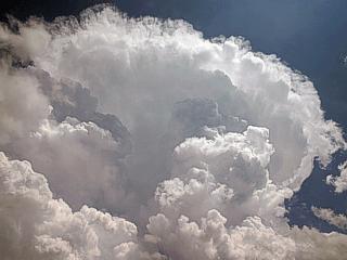
|
Here is a picture of convective initiation southeast of Hereford, Texas kicking off the start of this big chase day. Note the rock-hard development and back-sheared anvil with "knuckles". |
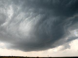
|
The first storm to go up southeast of Hereford, Texas takes on a rounded, mesocyclone appearance. This storm tried to build, but lost its punch as the more violent supercell near Crosbyton, Texas to the south began developing, cutting off the inflow to this storm. |
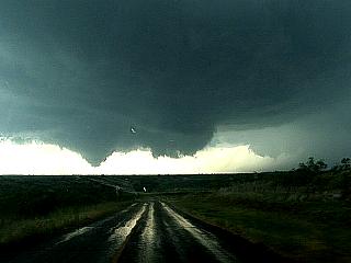
|
Here is a picture of the violently rotating wall cloud near Crosbyton, Texas with a pre-tornadic funnel. Note to the far right, another wall cloud and funnel in the distance. This was the original mesocyclone, as this storm is a CYCLIC SUPERCELL. The new wall cloud in this picture is to become a progressive and prolific tornado producer. I am also being pelted with golfball sized hail as I am driving into the "bear's cage"! |
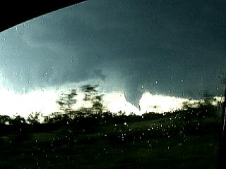
|
Just out of the golfball hail, tornado #1 briefly touches down as I am rapidly driving south to get out of the hail core. View of this tornado was out the passenger window looking west. |
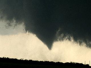
|
Tornado #2 spins up briefly on the southeastern side of the rotating wall cloud and forms a nice cone tornado - Note the debris / dust swirl under the condensation funnel confirming touchdown. |
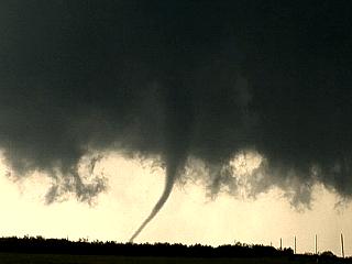
|
Tornado #3 develops quickly (blink and you'll miss the magic of tornadogenesis) into a slender rope under a violently rotating cloud base. |
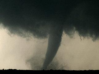
|
Tornado #3 strengthens and matures to a full-fledged "stove-pipe" tornado. This awesome tornado tears across open country southeast of Crosbyton, Texas for about 5 minutes, moving slowly, picking up lots of dust and debris. |
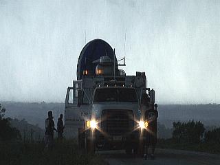
|
While re-positioning eastward to get out of the path of a new mesocyclone after tornado #3 dissapates, I come across the DOW (Doppler On Wheels) trucks scanning the storm. This was right UNDER the newly developing tornado #4 - Time to go! |
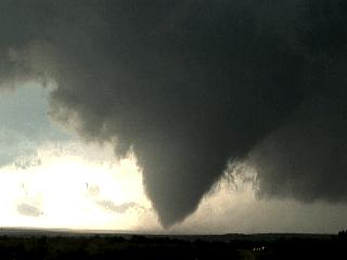
|
Tornado #4 develops just up the road and quickly becomes a large cone tornado condensed all the way to the ground. This tornado lasted a minute or two, then lifted back up into the violently rotating wall cloud. I was actually INSIDE this tornado when it was much weaker. |
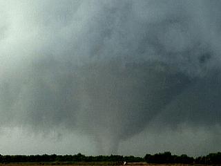
|
Tornado #5 develops north and leaves off where tornado #4 finished. This will become the largest tornado produced by this supercell storm. Here we see a nice funnel descenting from a violently rotating truncated cone. This is about midway between Crosbyton and Spur, Texas. |
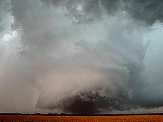
|
Tornado #5 quickly strengthens as the RFD blasts around it making the entire barrel updraft column visible. The base of this column is a violently rotating dusty "wedge" tornado. |
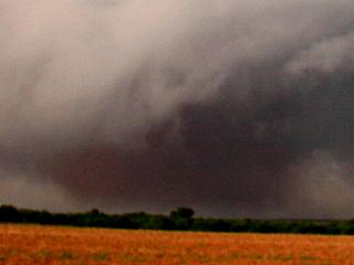
|
Here is a closup of the wedge tornado (tornado #5 at its peak intensity). Note the dark dirt in the wedge and lighter dusty inflow jets in the foreground at the base of the tornado. |
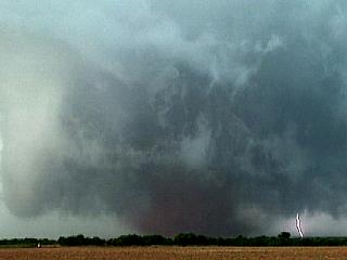
|
Here is a frame capture of CG lightning to the right side of tornado #5 during the wedge phase. |
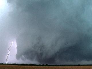
|
Here is another frame capture of CG lightning on the left side of the updraft column of wedge tornado #5. |
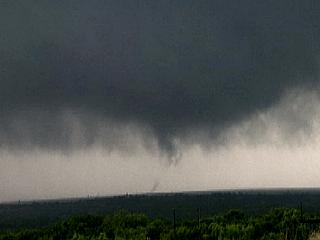
|
Tornado #5 occludes and disappears in rain and hail, cannot see it anymore, but it is still in there. Meanwhile, a new mesocyclone forms a mile or so to its southeast, near Spur, Texas. This produced another large tornado, which refer to as tornado #6. Tornado #6 was a MULTIPLE VORTEX tornado, and only its SUCTION vortices (subvortices) were visible as they went around the main tornado like a giant merry-go-round. This was the first suction vortex that tornado #6 produced. |
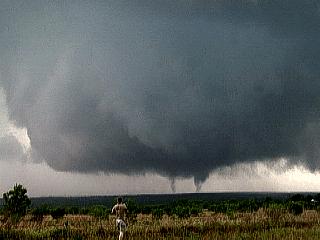
|
Tornado #6 produces two more small sub-tornadoes, simultaneously, as Stephen Miller (KD5FMI) watches in awe in the foreground. |
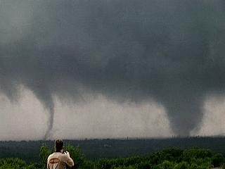
|
Yet two more simultaneous sub-vortices from tornado #6, both fully condensed, whip around the main tornado like an egg-beater. These are NOT the same tornadoes as in the previous picture above! Stephen Miller is standing in the foreground. |
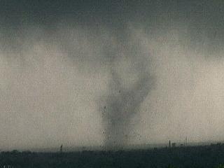
|
Still another suction vortex ripping around the larger circulation of tornado #6. This one hits a barn on the east side of Spur and disintegrates it. Note the fast-moving black "dots" in the air, that's flying boards, trees, and farm impliments! |
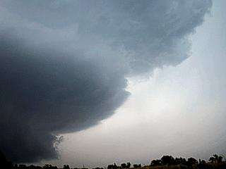
|
All the while the vault region of this classic supercell appeared like in this picture. Baseball to softball sized hail was being produced by this storm. Note the "mothership" appearance to the updraft edge. The view here is to the north while southeast of Spur, Texas. |
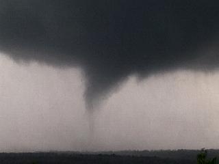
|
One more tornado, tornado #7, develops south of weakening multi-vortex tornado #6. This was a brief but powerful small tornado developing on the south side of the mesocyclone, which occluded shortly afterwards with CONTINOUS CG lightning forcing us to relocate again. |
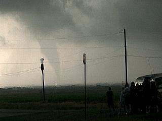
|
Not done yet ... Tornado #8 appears out of the RFD occlusion as the sun backlights the weakening supercell storm. This tornado was viewed for nearly five minutes as an "elephant-trunk" like in this picture! A new supercell to the southeast of this one near Aspermont, Texas finally "hushed" this monster storm by cutting off its warm inflow winds ... Things that make you go "Wow"! |
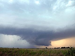
|
Here is a picture of a rotating wall cloud on the new supercell storm that developed southwest of Aspermont, Texas. This storm did produce a funnel cloud, but nothing like the former supercell to its northwest. Note the RFD wrapping into the left side of the picture. |
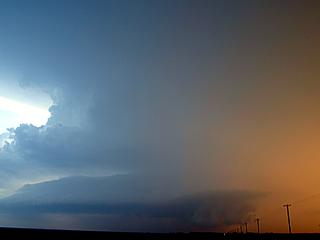
|
The supercell west of Aspermont, Texas during its weakening phase, still having a wall cloud and healthy updraft. The colors and structure of such a storm at sunset is a sight to behold, and can contain all the colors of the rainbow. |
HTML File "mwcl2005.htm" - Developed By Chris Collura
To Return To The HOME Page Of This Site Click The "INDEX.HTM" Link Here!