
| The storm chase expedition to the US Great Plains for 2004 is completed. There was a total of 20 travel days, of which, nineteen of these days were available for chasing. A total of 11 productive chase days, 2 "bust" days, and 6 down days occurred out of the 19 available days (Day 20 was a travel day). My portion of this storm chase expedition was from May 13 to June 1, with the full 20 days available for chasing / travel. The main "Weathervine" storm intercept team, neighbor and observer, Raul Benitez, and myself headed out for Dallas, Texas on May 13, 2004 and chased until June 1, 2004 (Raul Benitez returned to Florida on May 22, 2004 via a ticket-change to fly from Omaha, Nebraska). This was my fifth trip dedicated to severe thunderstorm research in this area, which includes the Great Plains and the Midwestern United States. Keep in mind that this chase log is scientific evidence and portrays my on-going storm chasing research. It has been placed on this page for easy reference and meteorological interests. Please do not plagiarize or copy this document to other sites for distribution. Note - This page may take a while to load on some SLOWER connections! |
| CHASER NAME | HOME CITY | CALLSIGN | CHASE DATES | OCCUPATION |
| CHRIS COLLURA | MIRAMAR, FL | KG4PJN | 5-13 TO 6-1 | IT CONSULTANT |
| JASON FOSTER | BALTIMORE, MD | N3PRZ | 5-13 TO 6-1 | ARCHITECT |
| JEFF GAMMONS | OKEECHOBEE, FL | KG4PGA | 5-13 TO 6-1 | PHOTOGRAPHER |
| KERSTEN MC CLUNG | OKEECHOBEE, FL | N/A | 5-13 TO 6-1 | HOSTESS |
| RAUL BENITEZ | MIRAMAR, FL | N/A | 5-13 TO 5-22 | WAREHOUSE MANAGER |
The participants below, with the exception of Amos Magliocco, are not from the "Weathervine" chase team. These people may have actively participated in our storm research efforts and deserve appreciation for their great help and severe weather expertise. Amos Magliocco chased this year 2004 from late April through mid June 2004!
| CHASER NAME | HOME CITY | CALLSIGN | OCCUPATION |
| AMOS MAGLIOCCO | BLOOMINGTON, IN | KC5VPD | WRITER |
| DOUG KIESLING | MINNEAPOLIS, MN | N/A | BNVN PRESIDENT |
| GARRY WELLMAN | ST LOUIS, MO | N/A | NETWORK ENGINEER |
| SCOTT EUBANKS | DALLAS, TX | KC5DES | POSTAL WORKER |
| TONY LAUBACH | LITTLETON, CO | KC0ONL | STUDENT |
| TRAVIS GIVAN | HANNIBAL, MO | N/A | MEDIA DESIGNER |
Please note that several other chasers may caravan or "converge" with us.
The following entries are all storm chases and interceptions performed in the Midwest United States from May 13, 2004 to June 1, 2004. This log is based on a joint effort of a storm chasing team. Members were myself - Chris Collura (Florida Skywarn storm spotter code B036 - KG4PJN), Jeff Gammons (Florida - KG4PJA), and Jason Foster (Maryland - N3PRZ) for the main chase team. This is jointly with the Weather Information Network or "Weathervine". Additional members were Raul Benitez and Kersten Mc Clung. The main chase vehicle was a 2004 Dodge Caravan rental. We had a large group and great vehicle this year. States chased: CO, IA, KS, MO, NE, OK, and TX. Total mileage: About 8,600 miles!
Communications employed are HF and VHF HAM radio, FRS hand-held radios, and cellular phones and / or modems. Extensive camera and video equipment was also on board along with GPS and a laptop computer for navigation. The main chase duties are shifts in navigation using the GPS, radio communications, driving many miles, and preparing forecast data. A portable weather station also was developed by myself to be used in this chase trip. I flew into Dallas, Texas on May 13, 2004 in the early morning to meet with the other chase team members, pick up the rental vehicle, and head to our first "target area". The chase involved large expanses of the US Great Plains sometimes in the worst driving conditions imaginable, in very remote regions. Total mileage is yet to be determined.
All chases and observations are in chronological order and a chase number is assigned to each entry. Please bear in mind that all observations adhere to modern storm analysis standards and do not include all storms that occurred in a given area for a particular chase period. The chase log is also augmented with a small chart at the conclusion the log showing types of observations.
Any kind of storm such as a thunderstorm, tornado, waterspout, tropical cyclone, and extratropical storm can be chased or observed. I have tried to keep this log of any storms that I have observed as accurate as possible, while using terms and expressions to abide by those used by most meteorologists and storm spotters today.
Storm chasing and observation can be extremely dangerous and may result in serious injury or death. I have received intermediate and advanced training for storm spotting in 1996. I strongly urge anyone who is to try their hand at storm spotting to get training before doing so. You must also have a good understanding of meteorology and storm dynamics. "If you don't know what you're doing, Don't do it!" Contact your local National Weather Service office for information on storm spotting and about training to become a Skywarn storm Spotter. It is also advised that chasing in the Great Plains is to be done only be experienced people as a group.
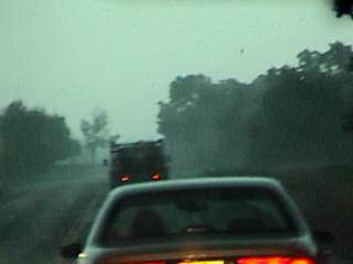
May 13 - Arrived in Dallas Fort Worth (DFW), Texas with my neighbor, Raul Benitez and met with the remaining chase team members Jeff Gammons (from West Palm Beach, FL), Jason Foster (from Baltimore, MD), and Kersten Mc Klung at the rental car center. Looked at data before picking up the rental vehicle targeting the area from Wicita Falls, Texas and points to the southwest based on upper air and surface analysis. At about 11 AM, we packed the vehicle (a 2004 Chrysler Town And Country) and headed northwest towards our primart target. At least two severe thunderstorms were encountered, one near Throckmorton County, Texas and the other near Abenine later in the chase. Copious amounts of marble sized hail were produced by these storms. Tornado prospects were possible but never happened because storms quickly became outflow dominant. Wrapped up the chase near Abeline, Texas and returned to Denton, Texas for the night where we met up with Amos Magliocco (from Indiana). The Sprint data connection worked great along the I-35 and I-20 corridors, making on-the-road internet and location updates possible!
May 14 - Down day (no storms). Today was basically a vehicle preparation and travel day. Cold front passage and cold air advection prevented any chase possibilities in the Great Plains. The vehicle was set up with all elecrtonics and weather equipment. We left Denton, Texas after having lunch with Stephen Miller (KD5FMI) and Robert Hall and headed up I-35 into Oklahoma City, Oklahoma. We stopped at OU in Norman on the way to see the Storm Prediction Center and spoke to Blake Naftel there. We then found a hotel north of Oklahoma City to spend the night and prepare for Mark Roscovich's "Storm Track" picnic on Saturday (the next day).
May 15 - Travel day and a stop at Rocky's (Mark Roscovich's) ranch for the Storm-Track picnic in Peidmont, Oklahoma. Began our journey northward on I-35 anticipating storms in south central Nebraska the next day. Traveled to Bellville, Kansas for a hotel stay-over by 10 PM.
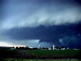
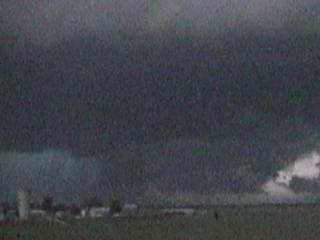
May 16 - Today was a great chase day with a cyclic tornado-producing supercell encounter from Buffalo County, Nebraska to near Rockville, where two brief tornadoes (of four known) were observed and documented. We forecasted and left Bellville for a target area near North Platt, Nebraska. We passed some elevated showers and stopped in Broken Bow looking at more data during a fuel stop. Storms began developing south of this area near Buffalo County. We raced south to this area and watched a cluster of thunderstorms evolve into a supercell storm which moved NE near 40 MPH. We were able to keep up with it during its entire 5 hour lifecycle, watching it evolved from classic and HP appearance. It was a cyclic storm and produced two tornadoes we were able to observe near Rockville, Nebraska. The storm moved along a 91 mile-long path and weakened to a multicell cluster of severe thunderstorms there after. Overall, a great chase day with 2 documented tornadoes.
May 17 - Another chase day with a tornadic supercell near Russell, Kansas. We targeted the area around Hays, Kansas after looking at data and eating breakfast at Kearney, Nebraska. We reached Russell, Kansas in time for initiation. After a couple of hours one severe storm evolved into a supercell thunderstorm with a vigorously rotating wall cloud. The storm was tornado-warned at this point and tornado sirens went off near the small town of Dorrance as it moved east of Russell. The storm came very close to tornadogenesis but occluded after a few cycles. The storm was followed until it weakened near the town of Wilson, with a path of about 35 miles and a two hour lifespan. The storm produced frequent lightning with close hits, one nearly a direct hit taking out some electronics on the vehicle! We stopped in Ellsworth to eat then traveled to Newton, Kansas to stay for the night.
May 18 - Today was a typical "cap bust" day! We left Newton, Kansas and stopped for breakfast then headed towards the area west of Wichita, Kansas anticipating good heating, a boundary, and good upper air support. The cap never was overcome by the heating and by 7PM we realized a "bust" was in progress. We called off the chase early and spent the night in Park City, Kansas.
May 19 - A very painful bust day to say the least. We departed Park City anticipating good upper level dynamics and a surface low / convergence area in eastern Nebraska / Western Iowa. We headed north early with a quick stop in Newton, Kansas to pick up some forgotton items on my behalf. We continued north stopping in Nebraska City, Nebraska to look at more data and wait for something to initiate. We headed into Iowa and stopped again near Audobon waiting for initiation. Cumulus began organizing bit never broke the cap. We headed back south, then southeast to Stuart, Iowa where some pretty interesting HCR (Horizontal Convective Rolls) were observed overhead. One cumulus tower took on a "mini supercell" stucture there but quickly petered out because of the strong cap. Realizing a 300+ mile drive was followed by a bust, as convection was inhibited by the cap and any storms that did develop were well to our north, we called off the chase and spent the night in De Soto, Iowa.
May 20 - Today was a great chase day which began with a very long road trip from De Soto, Iowa to just northeast of Denver Colorado with a driving distance of nearly 800 miles! The end of this trip was awarded with a beautiful supercell thunderstorm which was followed from its point of initiation near Weld County, Colorado northeastward to the northeast of Washington County. The storm began as a small LP supercell then evolved to HP and produced a large tornado near Akron, Colorado. We ended the chase and spent the night in Sterling, Colorado after this great and long chase day!
May 21 - Back to northeastern Nebraska for another great chase day. We targeted the area in NE Nebraska and did a long drive from Sterling, Colorado and were in the target area by about 6PM CDT. Changed Raul Benitez's airline reservation to leave from Omaha, Nebraska instead of Dallas. First convective initiation was encountered southeast of Oniel, Nebraska at about 7:30 PM with two supercell thunderstorms that quickly developed in that area. Both were intercepted, first the northern split-storm, which produced a funnel cloud then the southern storm, which also produced funnel clouds and continuous lightning as it evolved into an MCS well after dark east of Norfolk, Nebraska. We headed east after chasing and looked for lodging in far western Iowa near Interstate 29. Could not find any lodging in Iowa down to near Omaha. Finally found lodging 65 miles west of Omaha in Schulyer, Nebraska to spend the night. Drove Raul to Omaha airport in severe thunderstorms then returned to Schulyer to sleep for about 3 hours (tomorrow is another chase day)!
May 22 - Outbreak and high-risk chase day in south-central Nebraska. Today was an extremely volatile and dangerous setup. We left Schulyer, Nebraska and headed south stopping in York to look at data and await break of the capping inversion. During initiation, we headed west on I-80 towards highway 281 and headed south as a line of storms fired to the southeast of on-going convection to our west. We headed east on highway 6 east of Hastings to intercept the storm and had to back out because the storm split and golfball sized hail began hitting us. We headed back west, then south to highway 4 to go back east. The southern split storm became a monster tornadic supercell producing multiple large tornadoes. A large wedge type tornado occurred south of the storm core, and was observed very faintly from behind the storm headed east. Damage was observed along the way (tornado path), including a demolished two story house! After that, we navigated along back-roads to get to the southeast side of the supercell. Several funnels were observed and another large wedge type tornado (possibly?) to the northeast of Beatrice, Nebraska along highway 77. Sure enough, a small town northeast of Beatrice (Hallam) had severe damage according to preliminary reports. We spend the night in Beatrice after all activity passed on to our east. Damage assessment required tomorrow ... What a day!
May 23 - Today we took a day off from chasing and spent an extra day in Beatrice, Nebraska to do vehicle maintenance and repair damage to the Weatherlab III weather station. After taking care of some minor issues, we decided to go with BNVN manager Doug Kiesling to survey the damage in Hallam and verify the tornado track. The damage swath was a MILE WIDE in some places, and a depressing scene of destruction loomed over what little was left of the town of Hallam. 95 percent of the town was totally disintegrated! We documented the damage with permission from authorities / residents and left due to the 8PM curfew. Tomorrow may be another chase day so we spent another night in Beatrice.
May 24 - Today was a big chase day in three states in a another high risk setup. We left Beatrice after fueling up, forecasting, and stopping for supplies. We targeted our first storm after initiation neat Falls City, Nebraska. This was to become a prolific tornado producer, but we made the unforgivable sin of leaving our storm as we abandoned it after we followed it into Missouri near Oregon. It produced several wall clouds, some rotation, but quickly went HP so we headed west really fast to target and intercept another supercell near Bellview, Kansas. This storm had awesome structure, but became disorganized after producing a few funnel clouds (this storm did produce tornadoes, but we were still too late arriving on them). Convection began developing to our southeast, so we raced to south of Topeka where we punched an HP supercell storm core. Emerging near it's rain-free base, we found lowerings and funnels, but its tornado prompting the warnings either already happened or not at all (it was radar indicated). We learned that the supercell we left behind in Missouri produced over a dozen tornadoes (I hate when that happens - Always stick to your first storm until it is gone)! Overall, three supercells today, at least not a bust. We spent the night in Emporia, Kansas after dinner.
May 25 - Travel and chase day back in Texas for a severe thunderstorm near Abeline. We left Emporia and headed for our first target area near Lawton, Oklahoma. Storms began developing near Seymour, Texas so we raced southwestward across the Red River into Texas. We finally arrived to what was left of the storms just west of Abeline, Texas. The storm was a severe thunderstorm close to Dyess Air Force Base after dark. After chasing the storm, we wrapped up the chase and headed back north to Whicita Falls, Texas for the night.
May 26 - Today was a complicated chase day with technical problems with some equipment, a traffic stop, and interception of a left-split mini-supercell storm with a possible anticyclonic mesocyclone near Altus, Oklahoma. We left Wichita Falls, Texas and headed north on 277. Jeff Gammons, driving, was pulled over and cited for going only 5 MPH over the speed limit! After the traffic stop, we continued across the Red River into Oklahoma. We stopped just north of the state line to check data and handle technical problems. The data check prompted us to track west back into Texas and wait for initiation near Quanah, Texas. After driving around several times, we headed north on state road 6 where Amos Magliocco also was pulled over for going just above the speed limit! We finally targeted our storm near Altus, Oklahoma around 8 PM. The storm quickly intensified and split. We passed the north split, which had a pretty impressive LP structure, but had its precipitation core on the south side and may have been a "anti-mesocyclone" at one point. The south split quickly weakened and the north split began racing northeast at 45 MPH so we gave up on it. We spent the night in Elk City, Oklahoma.
May 27 - Chase day in Texas for a multicellular cluster with embedded supercells. We ate breakfast in Elk City, Oklahoma expecting only a marginal setup today. The new outlook came out from SPC just as we were wrapping up breakfast and leaving the hotel. Looking at more data, it looked more and more like a chase day south and east of Abeline, Texas. We left Elk City, Oklahoma and headed back into Texas. We checked data again in Haskell, Texas. We first encountered convection near Stamford, Texas but it quickly weakened. We continued east of Abeline on I-20 targeting a line segment of thunderstorms with embedded supercell storms. Our storm we decided to intercept was a severe thunderstorm southeast of Stephenville, Texas along highway 281. This storm started out as an embedded supercell but quickly evolved into a line bow segment that blasted us with strong winds. After the interception, the storms raced eastward and we ended our chase, heading back north and east in I-20 towards the DFW area. We spent the night in Denton, Texas.
May 28 - Travel day. Today was a long roadtrip from Denton, Texas to Beatrice, Nebraska. No storms were possible today in our immediate chase area, so we forecasted at a cafe with WIFI and decided to target Nebraska for a major weather event. We left Denton, Texas and traveled up I-35 through Oklahoma and Kansas then I-135 into Nebraska. Trip time was 9 hours, and we arrived at Beatrice, Nebraska in time for Dinner and spent the night there.
May 29 - High risk chase day ending with the interception of a tornadic supercell near Concordia, Kansas. We left Beatrice, Nebraska after forecasting and headed to Hebron, Nebraska and waited at a truck stop on the south side of town for a few hours. Initiation occurred around 4 PM, and we headed back to just west of Beatrice to stay ahead of the developing convection. The storms appeared to be multicellular with embedded supercells at first. We turned our attention towards the southern most cell west of Concordia, and decided to head towards it via highway 77 then west on highway 36. We reached the "monster" HP supercell north of Concordia near the small town of Cuba just in time to witness at least one or more large tornadoes. The supercell produced some of the most impressive mammatus I have ever seen, and had inflow winds over 60 MPH well away from its main updraft. The storm had a 60 mile track and laster more than 5 hours. By 9:30, the storm evolved into a weaker line of thunderstorms and we ended the chase. We traveled to Emporia, Kansas for the night but not before driving in 50 MPH southerly winds and some small hassles with our hotel reservations.
May 30 - Today was not a chase day. Convection and storms shifted eastward and we decided to stand-down on chasing today. We ate breakfast then left Emporia, Kansas and did a bit of sight-seeing near Enid, Oklahoma. We spent the night in Enid, removing and packing up the equipment atop the chase vehicle.
May 31 - Down day. We left Enid, Oklahoma and went to Ardmore, Oklahoma to spend time to kill at Murray Lake National Park to go jet skiiing and horesback riding. We saw the "Day After Tomorrow" movie in Ardmore and spent the night there. This is the last chaseable day of our trip.
June 1 - Travel day. We left Ardmore, Oklahoma at about 9AM and headed back south into Texas to Dallas-Fort Worth Airport (DFW). We all left from DFW back home (Baltimore and Florida). Amos Magliocco visited a few friends near Dallas and also started his way back to Indiana. This concludes our 20 day trip in tornado alley.
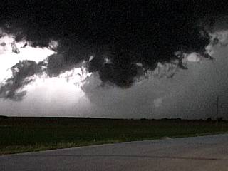
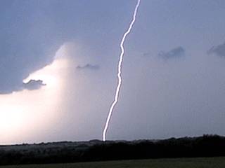
1). May 13, 4:00 PM - Penetration of severe thunderstorms just west of Throckmorton, Texas along highway 380. The thunderstorms were part of a multicell cluster of severe thunderstorms with short-lived embedded HP supercell storms. Winds near 60 MPH, heavy rains, and hail up to 3/4" was observed with these storms. This was the first storm intercepted this trip out. A low pressure trough, advancing dryline, and cold-front coupled with surface heating caused the storms. A tornado watch also was in effect for this area until 7PM CDT. Documentation was still photos and a camcorder.
2). May 13, 6:30 PM - Indirect Penetration of severe thunderstorms southeast of Abeline and southwest of Cisco, Texas along highway 36. The thunderstorms were formerly HP supercell storms that evolved into a multicell cluster of severe thunderstorms. Winds near 50 MPH, heavy rains, frequent lightning, and hail up to 1-inch was observed with these storms. Hail was found accumulated in drifts along the side of highway 36. A low pressure trough, advancing dryline, and cold-front coupled with surface heating caused the storms. A tornado watch also was in effect for this area until 7PM CDT. Documentation was still photos and a camcorder.
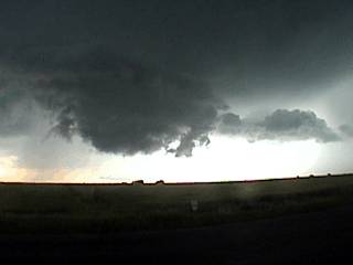
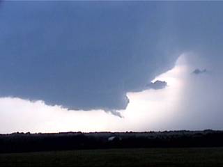
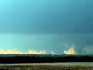
3). May 16, 7:00 PM - Observation of an extremely severe thunderstorm and two tornadoes from Buffalo County, Nebraska northeastward to the area northeast of the town of Rockville, Nebraska. The storm produced very large hail (not observed), frequent lightning, and two tornadoes which were observed near Rockville, which had the tornado sirens blairing. 65 MPH RFD winds were also encountered on the south side of the storm "bears cage" prior to intercepting the tornadoes. This storm produced a total of 4 small tornadoes, two of which were observed on this cyclic supercell. The storm was caused by surface heating, a low pressure system, strong winds aloft (directional and speed shear), and a surface boundary. Documentation was still photos, audio recording, and a camcorder. A tornado watch was in effect for this area until 7PM CDT.
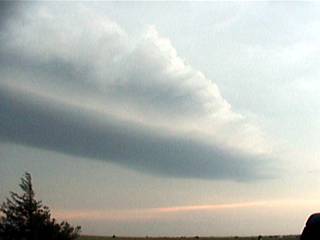
4). May 17, 7:30 PM - Observation of an extremely severe thunderstorm from near Russell, Kansas eastward near I-70 to near Wilson, Kansas. The storm produced very large hail at least 2 inches (not observed), frequent lightning with nearly direct close hits, and RFD winds near 60 MPH. The storm was a vigorously rotating supercell thunderstorm with a rapidly rotating wall cloud. The supercell mesocyclone caused the "stacked plate" effect to be visible on the eastern side of the updraft. The storm was caused by a surface heating, a low pressure system, strong winds aloft (directional and speed shear), and a surface boundary / dryline punch. Documentation was still photos, audio recording, and a camcorder. A tornado watch was in effect for this area until 10PM CDT. One CG lightning hit was so close that electronics were damaged by it. The Weatherlab dewpoint sensor was burned out, and a laptop battery was destroyed by the static field. The anemometer assembly was also damaged by the strong RFD winds.
5). May 20, 8:00 PM - Interception of a extremely severe supercell thunderstorm and tornado in Well and Washington counties, Colorado. The storm was first observed from its point of initiation over Weld County and quickly acquired LP supercell status. The storm was observed becoming increasingly better organized and had the classic "saucer" appearance due to the rapidly rotating mesocyclone. The storm cycled several times and blasted us with 60-70 MPH RFD winds at one point. The hail, at least 2 inches in diameter, was not intercepted. The storm produced continuous lightning as it entered Washington County and dropped a large tornado northeast of the small town of Akron, Colorado. After nearly 5 hours and about 70 miles of travel, the supercell evolved to LP again south of I-76 and gradually shrunk (dissapated). Documentation of this storm was a camcorder, still photos, and audio. The storm was caused by surface heating, upslope lift, and upper air trough, and weak surface low (high directional shear). A tornado watch was also in effect for this area until 11 PM MDT.
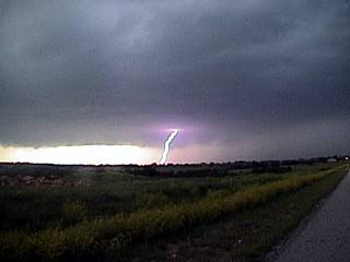
6). May 21, 7:30 PM - Observation of a very severe thunderstorm to the southeast of Oniel, Nebraska. The storm was a northern supercell thunderstorm in a cluster of two thunderstorms. Both storms developed explosively. The northern cell produced a rotating wall cloud with a funnel observed. Large hail to 3/4 inches, moderate rain, and 40 MPH winds were observed with this storm. We passed south of the storm's mesocyclone between it and the southern storm. The storm was caused by a low pressure trough / system, surface heating, and directional wind shear (jet stream aloft). Documentation was still photos and a camcorder. A tornado watch box was in effect for this area until 11 PM CDT.
7). May 21, 9:00 PM - Observation of an extremely severe thunderstorm to the east of Norfolk, Nebraska. This storm was a supercell thunderstorm on the south side of a thunderstorm line (tail end charlie) which became well organized sporting the "stacked plate" structure ahead of its RFD shelf cloud before slowly evolving into an MCS, which continued eastward for hours. The supercell storm had CONTINUOUS CC and awesome anvil "flicker" lightning during its highpoint, as it produced a large lowering and possible tornado northeast of Norfolk in Wayne County, Nebraska. Giant hail up to golfball sized was observed falling sporadically in a field a few hundred feet away. As this storm evolved to and MCS, it continued to produce 50+ MPH winds and continuous lightning, funnel clouds, and numerous rotating wall clouds were observed (the line of thunderstorms also contained embedded mesocyclones). These storms were caused by a low pressure system, surface heating and boundaries, and directional wind shear (jet stream aloft). Documentation was still photos, audio, and a camcorder. A tornado watch box was in effect for this area until 11 PM CDT.
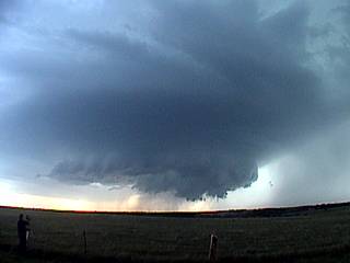
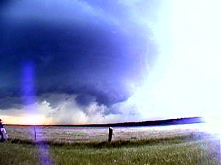
8). May 22, 7:30 PM - Interception and observation of an EXTREMELY severe, tornadic, and dangerous supercell thunderstorm from east of Hastings, Nebraska to north of Beatrice, Nebraska. This storm was a monster supercell thunderstorm that began as a classic supercell and evolved to an HP supercell at least 30 miles across. The storm produced at least 6 cyclic tornadoes. The first was a large wedge barely visible west of the storm (we were too late because we aborted a northern divert around the core of the supercell). The tornado path was crossed where power poles were snapped, grass scoured off the hillside, irrigation equipment was mangled, and worst of all, a two-story house was ripped apart by the previous tornado. The storm produced inflow winds up to 60 MPH even 5 miles to the southeast of the storm. The storm had hail to 4 inches (but only sporadic golfball sized hail was seen as we tried hard to avoid the core at all costs). Lightning was continuous. Multiple funnel clouds formed around the storms RFD flank. The supercell acquired a full "stacked plate" appearance, but this time, it stretched across the entire sky. A large wedge-type tornado (possibly) was observed about 15 miles northwest of Beatrice as the storm passed by. A faint, low roaring (train) sound was noted with this feature. Later, preliminary reports of damage came in from that general area, which we were only a mile or so away from at the time of the possible tornado! This storm was part of a severe weather outbreak caused by a dryline punch, upper air support (jet stream and wind shear), strong low pressure system, and intense surface heating. Documentation was still photos, a camcorder, and audio. A PDS (Particularly Dangerous Situation) tornado watch was also in effect for this area until 11 PM CDT.
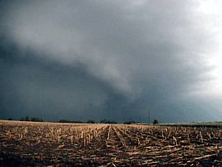
9). May 24, 4:30 PM - Observation of a tornadic supercell storm from near Falls City, Nebraska to northwest of Oregon, Missouri. This storm produced funnels and rapidly rotating wall clouds. We indirectly penetrated the storm, and experienced 50 MPH winds, heavy rains, frequent lightning, and hail to 3/4". The storm had hail up to baseball sized (core not penetrated and hail not observed at that size). This storm was abandoned due to poor road networks and went on to produce many tornadoes (not observed). A low pressure system, daytime heating, outflow boundaries, and wind-shear (jet stream) caused the storms. A tornado watch was in effect for this area until 10PM CDT. Documentation was still photos and a camcorder.
10). May 24, 6:30 PM - Observation of another severe tornadic supercell thunderstorm south of Bellview, Kansas. This storm was a classic (with an LP characteristic) supercell that was formerly tornadic (before intercepting it) and produced funnels and rapidly rotating wall clouds. The storm core was not penetrated but had inflow winds to 40 MPH from a few miles to the southeast. The storm weakened shortly after, but not before having an impressive visual apperance! A low pressure system, daytime heating, cold-front, dryline, and wind-shear (jet stream) caused the storms. A tornado watch was in effect for this area until 10PM CDT. Documentation was still photos and a camcorder.
11). May 24, 8:30 PM - Penetration and observation of severe thunderstorms south of Topeka, Kansas along highway 75. This storm was also a tornadic supercell that evolved to HP. It's core was penetrated where 60 to 70 MPH winds, torrential rains, frequent lightning, and hail to golfball sized was observed. The south side of the storm had a wall cloud, some funnels, but no major tornadoes. A low pressure system, daytime heating, outflow boundaries, and wind-shear (jet stream) caused the storms. A tornado watch was in effect for this area until 10PM CDT. Documentation was still photos, audio, and a camcorder.
12). May 25, 8:30 PM - Direct penetration of a severe thunderstorm near Dyess Air Force Base in Abeline, Texas south of Interstate 20. The storm was a severe thunderstorm and possibly a weak supercell storm. Torrential rains, winds gusting to 60 MPH, 3/4" hail, and frequent lightning with close hits. This storm had a small wall cloud along its rain-free base on its southern side. Winds were strong out of the east north of the storm core and light westerly south of it (possible mesocyclone). The storm was caused by a cold front, surface heating, and an upper level trough. Documentation was a camcorder. A severe thunderstorm watch box was in effect for this area until 10 PM CDT.
13). May 26, 8:00 PM - Obervation and indirect penetration of a very severe thunderstorm near Altus, Oklahoma. The storm was a strange left-split LP supercell type storm with golfball sized hail (not penetrated) and an anticyclonic mesocyclone. Conditions encountered with this storm were frequent lightning with some close hits, heavy rains, small hail, anf 50 MPH winds. The storm was caused by an outflow boundary, stationary front, surface heating, dryline, and an upper level trough. Documentation was still photos, audio, and a camcorder. A tornado watch box was in effect for this area until 9 PM CDT.
14). May 27, 7:00 PM - Observation and penetration of severe thunderstorms just southeast of Stephenville, Texas along highway 281. The storm was a bow-segment of a multicellular storm cluster containing embedded supercells (mesocyclones). The storm had a striated appearance with an inflow-notch and rain-free base for a short while, then it quickly evolved into a bow / line segment with destructive straight-line winds. On the south end of the cell in the line, winds suddenly increased to 80 MPH (or more) with sideways rains. Frequent lightning with close hits was also observed with this storm. The storm also contained large hail, but that area was avoided. Documentation was still photos and a camcorder. Wind damage was observed with this storm and the damage report relayed to the skywarn network (on HAM frequencies). The storm also produced a brief tornado (not observed) in addition to wind damage. The storm was caused by an advancing dryline, daytime heating, and strong upper level disturbance. A severe thunderstorm watch box was in effect for this area until 8 PM CDT.
15). May 29, 7:30 PM - Interception and observation of an extremely severe and tornadic supercell thunderstorm near highway 36 and west of the small town of Cuba north of Concordia, Kansas. This storm was a "tail end charlie" storm and produced multiple large wall clouds and / or tornadoes at the same time during its highpoint. Inflow winds 5 miles from the storm updraft exceeded 60 MPH, and were more than enough to cause wind damage to trees and structures. Hail in this storm was at least baseball sized, but the dangerous core of this storm was avoided at all costs. Frequent lightning with close hits was also observed in light anvil precipitation. The enhanced mammatus clouds from the supercell anvil resembled "sea anenome tentacles" rather than the typical "womens breast" appearance. A strong low pressure system, dryline punch, warm front / boundary, speed and directional shear (strong wind / jet stream aloft), and surface heating caused the storms. Documentation was a camcorder and still pictures. A PDS (Particularly Dangerous Situation) tornado watch was also in effect for the area until 10 PM CDT.
This concludes the Midwestern United States Chase Log. The summary includes a total of 15 severe thunderstorms and about 6 tornadoes (or large funnel clouds). The main chase vehicle conducting all chases was a 2004 Chrysler Town And Country. A 2004 Toyota 4-Runner (Amos Magliocco) was also used. This information was prepared exclusively for the National Weather service and the team of Skywarn storm spotters.
|
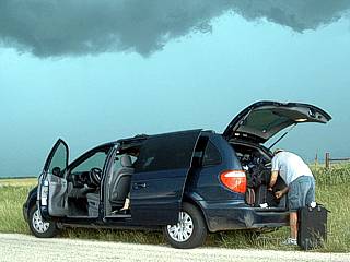
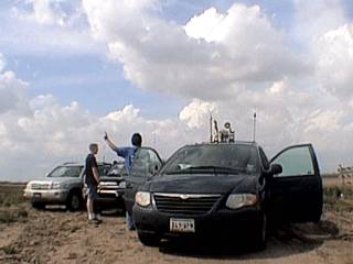
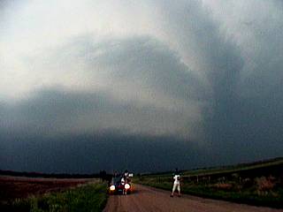
The Weathervine storm intercept team pulls over near Seymour, Texas to check out some linear convection with embedded severe thunderstorms. The main vehicle, without any equipment installed yet, is a 2004 Chrysler Town And Country. |
|
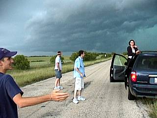
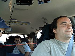
Here is another picture of the Weathervine storm intercept team observing the line of thunderstorms near Seymour, Texas. From left to right is Jeff Gammons (KG4PGA), Raul Benitez (neighbor), Jason Foster (N3PRZ), and Kersten Mc Klung. The storm here is quicky becoming outflow dominant. |
|
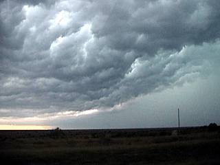
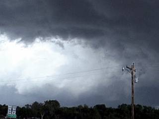
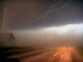
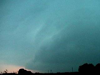
As the storm near Seymour "gusts out", the backside of the gust front makes for a turbulent sky. Temperatures dropped from 85 degrees to about 57 degrees with the passage of the gust front! |
|
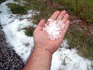
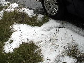
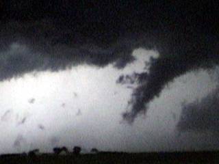
One portion of the thunderstorm line contained some short-lived HP supercells near Abeline, Texas along highway 36. These storms dumped copious amounts of marble sized hail which was still accumulated in hail "drifts" along the side of the road about 15 minutes after the storms passed through (hail streak). |
|
This is another picture of hail drifting along the roadside (highway 36). This is not snow. It is hail ranging from the size or peas to nickels (some isolated pieces to about quarter sized were found). |
|
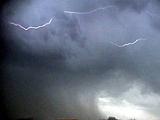
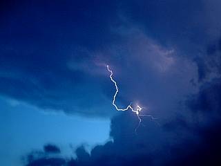
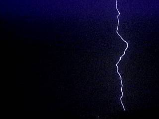
A cloud to cloud (CC) lightning strike occurs in a storm anvil / precipitation area off Interstate 20 near Cisco, Texas. |
|
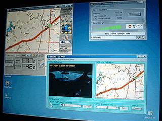
One of the most astounding aspects of our first chase day was using the Sprint / Merlin data cards to connect to the Internet / transfer data. The screen shot here shows the GPS navigation software (Delorme Street Atlas 2003) running in the upper-left, the Sprint connection utility, showing full signal / data, in the upper-right, and the location-updator software (developed by myself in VB) which sends a webcam image and the GPS location up to a server (such as Sky-chaser or the Weathervine servers). |
|
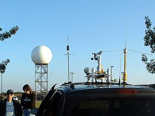
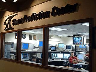
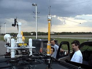
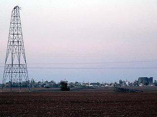
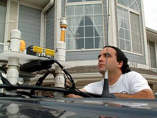
Here is the Chrysler Town And Country with the Weatherlab III installed atop it along with the Wilson Cellular antenna and high-gain ground plane / discone antennas. Note the large radome in the background for one of the WSR-88D (doppler) radars. This was at the Storm Prediction Center (SPC) in Norman Oklahoma on the Oklahoma University campus. |
|
This is a picture of the forecasting / science support center in the Storm Prediction Center / NSSL (National Severe Storms Laboratory). Chasers call this area the "fish bowl" because authorized people in the center view the meteorologists through windows. This center is responsible for issuing convective outlooks, discussions, and weather watches as well as fire outlooks and other advisories. |
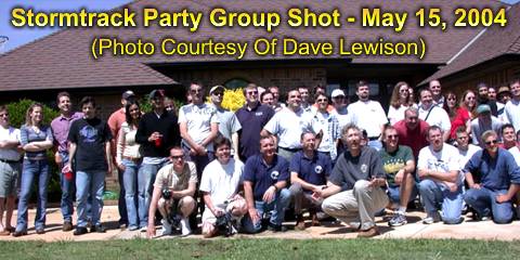
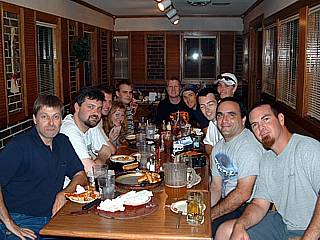
The picture above was taken by Dave Lewison and shows a group shot of some of the chasers in front of Mark Rascovich's ranch home in Piedmont, Oklahoma. Mark "Rocky" Rascovich, host for this event, is the fifth person from the left in the very front row. Myself and our chase group is the next row just behind.
|
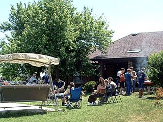
This picture shows the back yard at Mark Rascovich's ranch house in Peidmont, Oklahoma with some chasers mingling and eating. A total of nearly 100 chasers showed up during the day, including tour groups. |
|
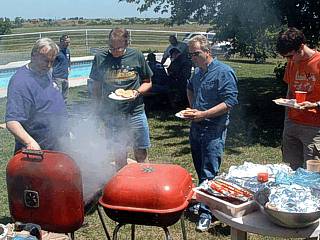
This is a picture of the barbacues at the storm chaser picnic at Rocky's ranch house. Food included hotdogs, hamburgers, chicken, cold-cuts, crackers, cheese, deviled eggs, and chase videos! |
|
The Weathervine storm chase team stops along the side of highway 183 in Buffalo County, Nebraska to watch a cluster of weak thundertorms that will evolve into a supercell thunderstorm. |
|
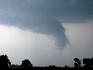
Here is a picture of the small rotating wall cloud viewed from near highway 183 in Buffalo County, Nebraska. The supercell thunderstorm is developing here and has just produced its first wall cloud. This storm was to later produce four small tornadoes. |
|
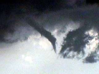
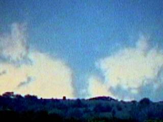
A small funnel develops on the wall cloud of the developing supercell thunderstorm near Buffalo County, Nebraska along highway 183. |
|
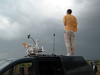
Jason Foster (N3PRZ) stands atop the Chrysler Town And Country rental next to the Weatherlab III to get a better photo of the developing supercell storm in Buffalo County, Nebraska. |
|
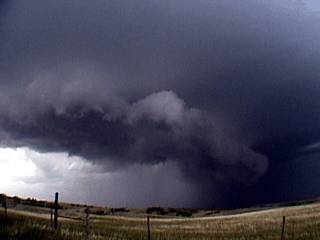
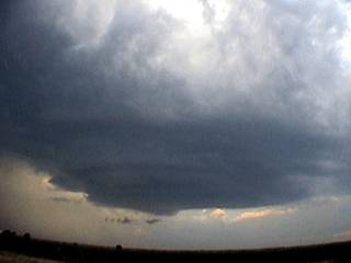
Finally, the supercell storm tightens its rotation and spins up into an intense mesocyclone. The view here is looking north in extreme eastern Buffalo County and shows the RFD gust front, inflow "notch", and vault regions of the storm. Inflow winds were estimated at about 40 MPH at times from the ESE and quickly veered to SSW then SW as the storm passed to the north of us. |
|
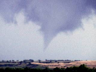
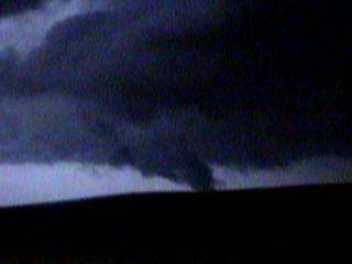
The supercell storm produces a brief tornado just northeast of Rockville, Nebraska after the supercell (parent) storm traveled for another 20 miles. |
|
A funnel (possibly a shear funnel) developes on the leading edge of the RFD shelf cloud near Rockville, Nebraska. This feature WAS rotating, but was not connected to the mesocyclone core of the storm farther to the northeast. |
|
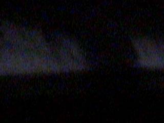
Here is a video capture of the second tornado that formed about 5 or 10 miles to the ENE of Rockville, Nebraska. |
|
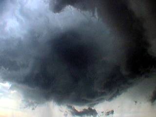
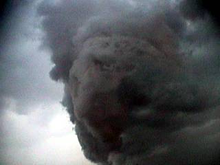
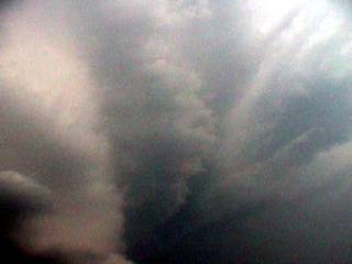
Here is the "horse shoe" updraft effect caused by a huge dry slot (RFD punch) behind the mesocyclone as the tornadoes formed northeast of Rockville. Note the "punch" of dry air (subsidence hole) extending from left to right. Also note the lowerings in the center of the picture just behind the dry RFD slot. |
|
The supercell storm finally evolves to a large HP supercell and its RFD occludes. The result is a rain and hail filled updraft. This is after the storm produced the tornadoes near Rockville, Nebraska as it continued northeast another 20 miles. This picture is also looking north into the RFD and mesocyclone core. Note the banding and hail shaft just behind the RFD shelf cloud. |
|
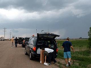
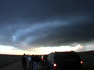
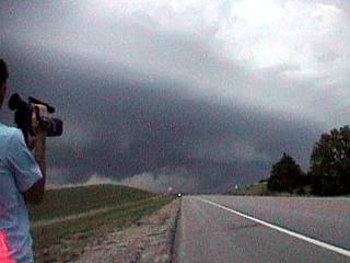
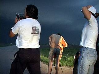
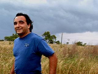
After arriving in the target area near Russell, Kansas, Jeff Gammons along with other chasers wait for storm initiation. The cumulus in the sky begins to grow and eventually will mature into thunderstorms. |
|
A while later, the first towering cumulus develops, confirming our target near Russell is correct in terms of moisture convergence and convective initiation. During storm initiation, several thunderstorms may occur, until one "dominant" cell becomes the main updraft (possibly to become a supercell storm). |
|
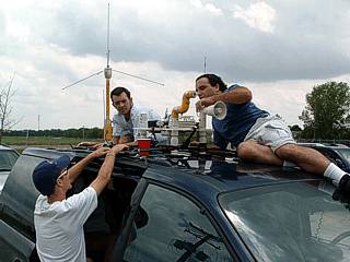
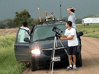
This is a view of the top of the Chrysler Town And Country chase vehicle and topside equipment (before being damaged from todays storms). Note the developing cumulus and thunderstorms in the sky as chasers in the foreground wait. |
|
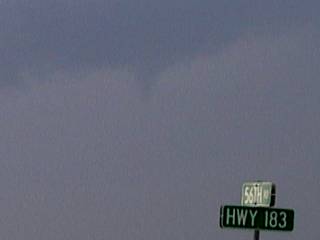
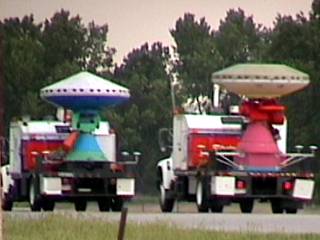
Two DOW (Doppler On Wheels) vehicles pass by while waiting for storms to organize west of Russell, Kansas near highway 183. |
|
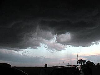
A wall cloud develops on the south side of a severe thunderstorm (developing supercell) near Russell, Kansas an hour or so after initiation. The storm quickly becomes severe and develops a rotating wall cloud. The view here is to the ENE and shows the wall cloud viewed from inside the vehicle. The streak in the windshield is a crack from road debris a few days earlier. |
|
The wall cloud develops more and more rotation as the storm acquires full supercell mode with a weel-developed mesocyclone. Note the tail cloud extending northeast of the rotating wall cloud. View is to the north about 5 miles SE of Russell, Kansas. |
|
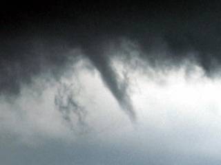
Here is the same wall cloud several minutes later. The view is to the WNW and the wall cloud is rapidly rotating. This was the closest it came to producing a tornado. This was about 10 miles ESE of Russell, Kansas north of I-70. |
|
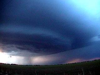
Here is a spectacular view of the entire mesocyclone and "stacked plate / saucer" effect of the east side of the rotating supercell. Note the striations in the mid-levels of the storm, rotating wall cloud at its base, and precipitation (giant hail) to the right. |
|
Here is a picture of an inflow band extending from the supercell storm eastward during the highpoint of the storm. These bands, also called feeder bands, are caused by air flowing into a supercell and converging, especially near boundaries the supercell may be interacting with. |
|
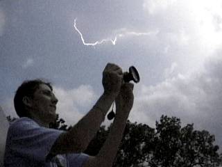
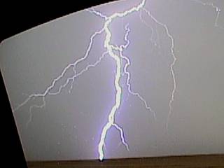
This is a video capture of a nearly direct hit of CG (cloud to ground) lightning less than 50 feet away! The fence post to the far right is being struck and the brilliant light "washes out" any details of the actual lightning bolt. This was a close call, Scott Eubanks is standing in the far left holding a tripod and was lucky he was not touching the fence! Note the brightness and lense flare caused by the light. The storm and wall cloud is also being illuminated from the foreground by this strike. The intense static field damaged electronics on some of the chase vehicles, and fortunately, no one was hurt. |
|
A few seconds after the "near death" hit by the lightning, another close hit, about a mile away, strikes in front of the supercell storm. Jason Foster is in the far right side of the picture, still with a startled look from the close hits. |
|
Here is another picture of a close CG lightning hit about a mile away near Wilson, Kansas from the same supercell during its weakening stages. |
|
The supercell storm finally gets smaller and its mesocyclone becomes less defined near Wilson, Kansas after a lifespan of over two hours. The chase vehicles are in the foreground. Note the dense precipitation chaft resembling a tornado to the right. this is NOT a tornado, just rain and hail falling from the weakening storm. |
|
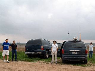
Nothing like a great dinner at Pizza Hut in Ellsworth, Kansas to wrap up a chase day. Here our group meets up with several other chasers in what is called a chaser convergence (other chase teams crossing paths at a restaurant, gas station, etc). Scott Eubanks, Raul Benitez, Myself, Amos Maggliocco, Jason Foster, Scott Blair, Kersten Mcclung, and Jeff Gammons are at the close end of the table. |
|
Here is a picture of Jason Foster and Myself atop the chase vehicle making repairs to the Weatherlab III station while waiting for the cap to break southwest of Wichita, Kansas. |
|
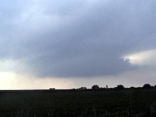
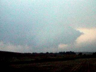
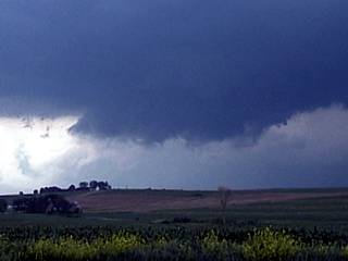
This is a picture of a small cumulonimbus base that developed west of Wichita, Kansas along a boundary. This was all that developed, and the cap was never overcome, and all convection petered out. This small convective shower does have a weak non-rotating wall cloud type feature on its updraft base. |
|
The chase team caravans with several other chasers atop a hill in Audobon, Iowa waiting for convection to start in an environment favorable for tornado producing thunderstorms. In this picture, Jeff Gammons stands in front of the Weathervine chase vehicle (center). |
|
Near Stuart, Iowa, a cluster of enhanced cumulus develops along a horizontal convective roll (HCR) and actually looks like a "mini supercell". This cloud feature was rather small and did not last long because of a strong capping inversion. Note the little vault like appearance to the right and inflow "banding". |
|
This picture shows the rear of Tony Laubach's chase vehicle during a chaser convergance and fuel-stop just south of highway 2 in Nebraska City, Nebraska on a bust day. |
|
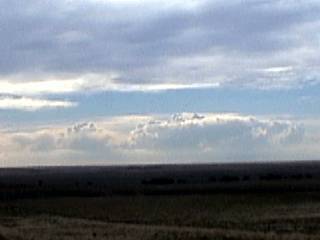
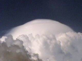
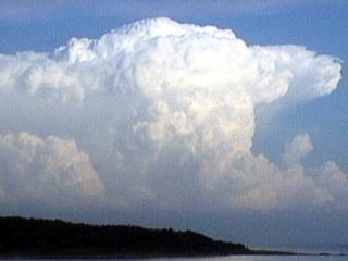
This picture shows the very first development of cumulus in the upslope flow as an upper level disturbance moves off the rocky mountains northeast of Denver, Colorado. This small cumulus field is yet to develop into a monster supercell storm. |
|
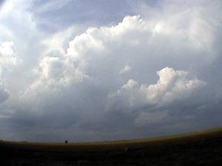
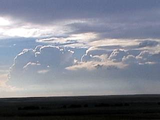
The cumulus grows and breaks the capping inversion by about 7PM MDT over Weld County, Colorado. The "harmless" cloud here is growing vertically and has passed the level of free convection. |
|
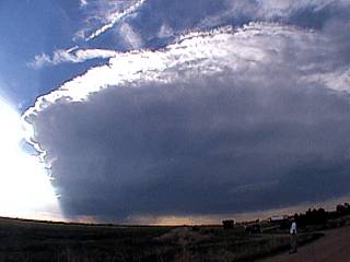
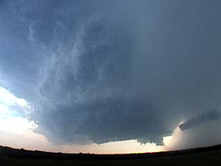
Finally, the storm grows into a thunderstorm and begins rotating on a broad scale. This storm has now become an LP supercell thunderstorm. |
|
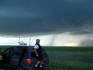
Here is a picture of myself standing on the back of the chase vehicle with the supercell storm in the background. Note the vault and wall cloud to the right. |
|
Here is another picture of the group of chasers and the developing LP supercell (note the distinct rotation) overhead! |
|
Here is another picture of the intensifying LP supercell RFD gust front and "saucer" effect. The view is to the north and northwest. |
|
This is the clear RFD (Rear Flank Downdraft) region "punching" in behind the supercell storm (note the clear air channel in the storm base). |

|
A blast of RFD winds buffets chaser Jeff Gammons as he tries to steady himself and his camera equipment. Winds here are about 50 MPH. |
|
We get hit by the RFD again as we try to rush east to get ahead of the supercell thunderstorm. Winds here are gusting over 65 MPH kicking up lots of dust. |
|
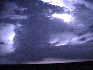
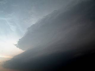
Just west of Washington County, Colorado, the storm evolves to an HP supercell in better moisture and helicity (backed winds). A funnel and scud cloud gets illuminated by lightning as it is after dark. |
|
Lightning became an important player with this storm because it allowed us to chase it after dark. Continuous lightning illuminates the entire storm allowing photography of the storm long after sunset. |
|
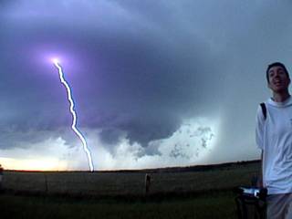
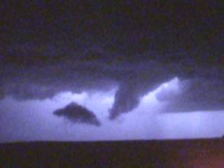
A large tornado touches down just northeast of Akron, Colorado in Washington County at 9:30 PM MDT. The view here is northeast and we are about 10 miles from the tornado touchdown. Lightning provided the light for this video-frame grab. |
|
Here is another view of the tornado illuminated by lightning a few minutes later. |
|
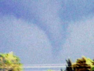
The tornado, which lasted for about 5 minutes, aqcuires a "wedge" structure at about 9:40 PM MDT northeast of Akron, Colorado before lifting. Again, lightning provided the light for this picture. |
|
After 10 PM MDT, the supercell thunderstorm continues to the northeast and evolves back to LP mode (before finally dissapating). The storm here is illuminated by lightning, and you can still make out a wall cloud in the lower portion of the cloud base. |
|
Explosive development of a supercell thunderstorm southeast of Oniel, Nebraska looms in the windshield of our chase vehicle. Updrafts over 100 MPH give the storm updraft (view is to the east) a rock-hard "cauliflower" appearance. This was a portion of the storm that was to later produce tornadoes. |
|
Shortly after the above picture was taken, the supercell thunderstorm produces a large rotating wall cloud and funnel as we pass just south of the storm rotation core (mesocyclone). We are not 100% sure if this feature actually touched the ground. |
|
Here is a picture of a large and vigorously rotating wall cloud to the northeast of Norfolk, Nebraska in Wayne County. This was the same area where a small tornado touched down. The supercell here was the southern storm on a line of severe thunderstorms / supercells (called the "tail end charlie" supercell). |
|
Here is another picture of the same wall cloud a few minutes later with the Chrysler Town and Country chase vehicle making a U-turn in the foreground. |
|
This picture shows the supercell storm crossing the road to our north over Wayne County, Nebraska. Note the wall cloud just over the road. The storm here was just beginning to evolve to a cluster of very severe thunderstorms and has an "elliptical" shaped mesocyclone at the time this picture was taken. |
|
Here is a view of the southern "tail end charlie" storm updraft with a nice CC (cloud to cloud) lightning strike through the storm tower and anvil "crown". |
|
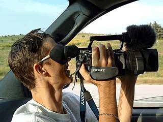
Here is another picture of Jeff Gammons (KG4PGA) taking a digital photo as a cloud-to-cloud lightning fires overhead in the storm anvil. |
|
A funnel cloud gets produced by the storm. Although the storm evolved into an MCS (cluster or line of thunderstorms), some cells still had rotating updrafts (mesocyclones). The cell in this picture produced the needle funnel about half way to the ground. Illumination was provided by the lightning. Note the police officer to the right, who reported ther funnel to the weather service. |
|
This is a video frame grab of a semi-trailer blown over from strong outflow winds after the supercell storms evolved into an MCS (line of thunderstorms) which plowed through Nebraska and the city of Omaha. This picture if between Fremont and Schulyer Nebraska. |
|
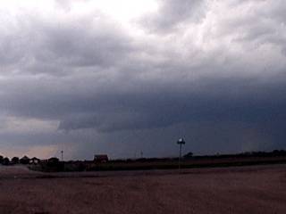
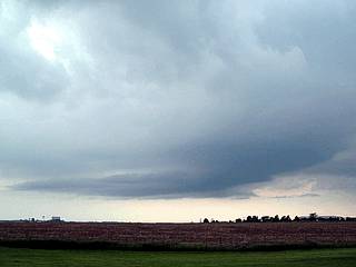
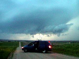
Waiting for the cap to break just west of York, Nebraska on a major severe weather outbreak (SPC high-risk) chase day. |
|
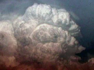
During initial storm development, a developing cumulus cloud "explodes" vertically and develops a glaciated top called a pileus cloud. |
|
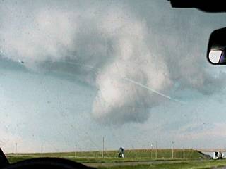
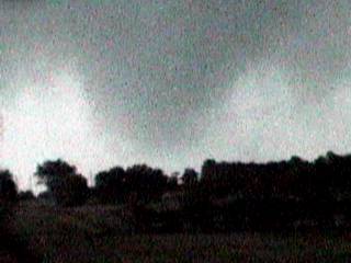
Mammatus clouds fill the sky east of Hastings, Nebraska near highway 6. These mammatus clouds are under an anvil from a tornadic supercell to the southwest. We were targeting a new storm to the southeast that was to produce the destructive tornadoes that would destroy the town of Hallam. |
|
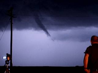
Barely visible as we were late arriving to the proper area of this supercell, a possible wedge tornado can be seen far to the east through the southern side (and rain hook) of the supercell. Look between the rain drop and the power pole to the left in the center of the picture near the ground. |
|
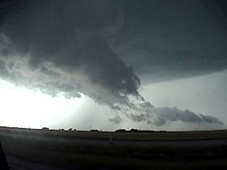
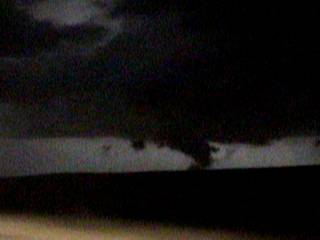
Here is a picture of the southern side of a violently rotating supercell storm north of Highway 6 about a half hour before producing devastating mile-wide tornadoes destroying the town of Hallam, Nebraska. Note the large lowering to the right of the wall cloud (far right), that is the beginning of the Hallam wedge tornado. |
|
During the highpoint of this monster supercell, the storm created inflow winds between 50 and 60 MPH, from the southeast. In this picture, we are looking to the north and northwest. The winds here can be seen flapping our shirts and hair. Note the winds are blowing TOWARDS the supercell! |
|
During the highpoint of the supercell, with 60 MPH inflow winds, the view above reveals the "barber pole" of the storm updraft. Note the striations high above in the storm upper structure. |
|
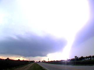
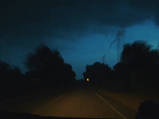
Possible developing wedge tornado behind the RFD clear slot (illuminated by lightning) prior to striking the town of Hallam, Nebraska. The town recieved major damage shortly after this picture was taken. Note the right side of the "wedge" ... Where is the left edge? This tornado was 2.5 miles wide at one point!! |
|
Here is the same developing wedge, later to strike and devastate Hallam, Nebraska, illuminated by lightning. Note the RFD clear slot in the foreground and scud lowering (new meso developing). The wedge tornado is BEHIND the dark lowering in the foreground, and is part of a tornado that was up to 2.5 miles wide! |
|
Here is a picture of a funnel cloud to the southeast of the RFD punch (background) on the southeastern side of a violent supercell near Beatrice, Nebraska to the north of highway 4 and west of highway 77. |
|
Another funnel develops along the RFD gust front to the northeast of Beatrice, Nebraska. |
|
In this highly processed picture, illuminated by lightning, we can barely see the wall cloud and developing tornado that was to slam into Hallam destroying 95% of the town. The wall cloud is clearly visible in this poor-quality video frame-grab, but was part of a mile-wide tornado that destroyed the small town of Hallam. This picture was taken just minutes before the tornado (which was wrapped in precipitation). |
|
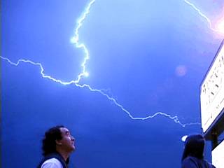
Here is a frame-grab from Jeff Gammon's video of cloud-to-cloud lightning high over myself and Jason Foster in front of the Victorian Inn motel in Beatrice, Nebraska after a busy and destructive chase day. |
|
On a down day, we take time to clean the vehicle and make minor / temporary repairs on the weather station, vehicle, and equipment. |
|
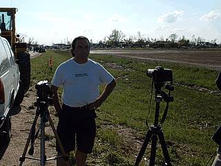
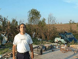
Here is a picture of myself, with a sad face, at the eastern edge of Hallam, Nebraska while doing a damage survey with Doug kiesling (BNVN / The Weather Challen Media). Note the background, damage is extensive. |
|
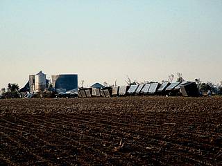
A train was derailed in Hallam, Nebraska from the mile-wide tornado. This is strong F2 tornado damage. |
|
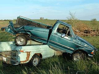
Here are two pickup trucks that were deposited, one on top of the other, after being lofted from a demolished garage on the west side of Hallam. |
|
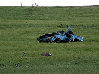
Another mangled car, possibly a pickup truck or minivan / SUV, is deposited in the center of a large field in Hallam, Nebraska. |
|
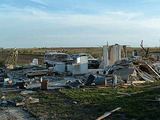
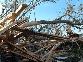
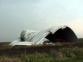
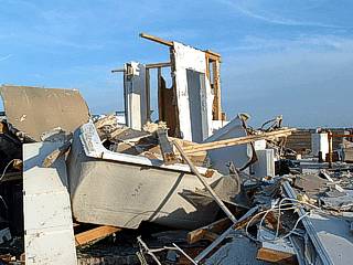
This WAS a two story house (yes, this WAS a house, not a junk pile) with a two car garage that was totally disintegrated by the tornado on the west side of Hallam. Damage here is strong F3 (possibly F4). Note the two cars in the space which was once inside the garage. The occupants of the house were away when the tornado hit. |
|
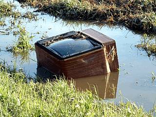
This TV set came to rest after being lofted from a demolished home and carried nearly 1/4 mile (most likely from the home in the picture above). |
|
This picture shows the extent of damaged trees around a home in Hallam, Nebraska. |
|
High tension wires hear a power plant / substation west of Hallam were downed by the tornado. Note the tower has its top structure missing and its remains landed in the field to the right of the tower. Note the severe damage to the west side of Hallam in the background. |
|
A large and vigorously rotating wall cloud develops on the south side of an HP supercell as it crosses the Missouri River from Nebraska to Missouri. Note the lowerings and large funnel behind it. The RFD slot is coming in from left to right. This storm became a prolific tornado-producer once in Missouri / Iowa. |
|
Here is a classic supercell thunderstorm near Bellview, Kansas. This storm, with some LP supercell characteristics, has awesome structure including a large wall cloud, funnel, vault, and hail shaft. This storm produced tornadoes and funnels. |
|
A cloud to ground (CG) lightning strike slices through the hail shaft of the classic supercell near Bellview, Kansas. |
|
This is a closer view of the wall cloud (note the little funnel) in the Bellview, Kansas supercell. |
|
A funnel cloud develops within the wall cloud region of the Bellview, Kansas supercell. |
|
Looking overhead, a counter-clockwise spin appears in the supercell base south of Bellview, Kansas. Note the clear "slot" wrapping around the circulation of the mesocyclone. |
|
A developing supercell thunderstorm viewed from about 45 miles away (storm was producing tornadoes southwest of Topeka, Kansas at the time). Nice back-sheared anvil. |
|
This is a picture of the western anvil of the storm south of Topeka, Kansas. Note the rock-hard anvil edge, and hazy sun. These storms were developing very close to the dryline. |
|
With golfball hail and lightning, this is a view of the storm updraft base. Nice CG through the rain-free base in front of the wall cloud of this HP storm. |
|
A low and ragged portion of the wall cloud rotates in front of us south of Topeka, Kansas in the "bears cage" area of an HP supercell thunderstorm. |
|
A cloud to ground (CG) lightning strike occurs in front of the chase vehicle while penetrating the hail-core of a severe thunderstorm near Abeline, Texas. Jeff Gammons shot the video that this picture was taken from. |
|
Jeff Gammons gets a speeding ticket for going only 5 MPH over the speed limit in Texas north of Wichita Falls just south of the Red River enroute to Oklahoma. Authorities are becoming more and more stringent with storm chasers and traffic violations no matter how small they may seem. |
|
Amos Magliocco caravaning ahead of us also gets pulled over for going slightly above the speed limit. |
|
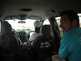
Here is a wide angle shot taken by myself inside the chase vehicle while penetrating a severe thunderstorm near Altus, Oklahoma. Jason Foster is to the right, Jeff Gammons is driving, Kersten Mcclung is in the passenger seat. Lots of equipment fills the remaining space. |
|
This is an LP supercell that formed the left-split of a thunderstorm complex. The view is to the west, and we can see several strange differences from a "normal" supercell. Note the precipitation is to the left (not the right). The vault region is also to the left. The inflow is coming in from the right (not the left as usually found in supercells). It is quite possible that this was an ANTI-MESOCYCLONE, or a CLOCKWISE rotating updraft. The storm did not last long, and raced to the NE at nearly 50 MPH. Note the "stacked plate" effect. |
|
A majestic but dangerously close hit of cloud to ground lightning slams the field a quarter mile or so away from our vehicle south of an anticylonic left-split supercell near Altus, Oklahoma. |
|
This is a rather interesting cloud feature along an outflow boundary. A weakening HP storm was to its west. The lowering in this picture even has a slight "twist" to it. |
|
Here is a radar picture from my laptop screen showing an HP supercell type storm embedded in a line of thunderstorms east of Abeline, Texas north of Interstate 20. |
|
Here is a picture of an HP supercell storm embedded in a line of thunderstorms just before it evolved into a bow segment. If you look closely, you can make out a rain-free base and even some striations in the updraft tower. |
|
Winds gust well over 70 MPH on the southern end of a bow segment containing damaging straight-line winds. Note the small pieces of debris in the air. |
|
Here is a picture of myself standing in 40 MPH winds after gust front passage on the outhern end of a destructive bow segment. This was after the worst winds passed. Note the backside of the shelf cloud to the right. |
|
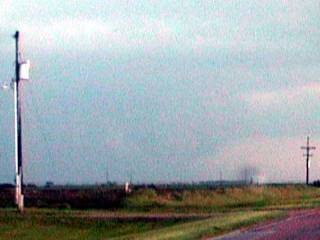
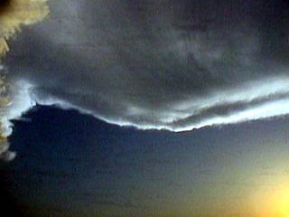
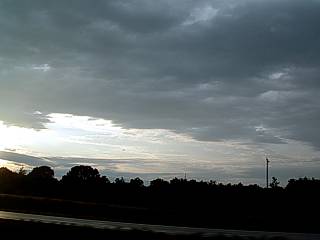
The dryline pushes eastward across western Texas after our chase ends this day. The dryline is marked by the sudden "stop" in the low clouds. |
|
Here is a picture of Myself, to the left driving, and some others in our chase vehicle during a roadtrip from Denton, Texas to Beatrice, Nebraska. |
|
This is Jeff Gammons playing with his Sony VX 2100 camcorder, actually he is filming Doug Kiesling driving next to us. |
|
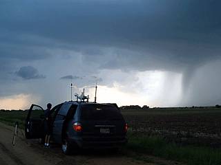
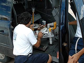
Here is a picture of myself inspecting the weather station and communications equipment atop the chase vehicle in Beatrice, Nebraska prior to a high-risk chase day. |
|
This picture shows the Weathervine chase team standing in 50 to 60 MPH inflow winds southeast of a tornadic supercell off Highway 36 north of Concordia, Kansas. |
|
This picture shows the chase vehicle and storm chasers from the Weathervine storm chase team with the barber pole updraft of a tornadic supercell north of Concordia, Kansas looming overhead. |
|
Here is a close up of the "bears cage" of the tornadic supercell north of Concordia taken from Highway 36. Note the RFD slot in the foreground cloud deck. How many tornadoes can you find? How many wall clouds do you see? |
|
A large tornado touches down between two massive scud tags on the SW side of the tornadic Concordia, Kansas HP supercell. |
|
Looking over the beaver's tail extending northeast of the updraft of the Concordia storm, we can see a "stacked-plate" or "barber pole" effect on the updraft tower. |
|
Inflow winds, even 5 miles away from the storm, were so strong that they destroyed this utility shed in a field off Highway 36 (north of Concordia, Kansas). Inflow winds exceeded 60 MPH and were enough to draw dust into the storm obscuring the tornadoes within from view. |
|
Here is another picture of the "mothership" or "stacked plate" effect of the Concordia supercell. This is looking west towards the southwest side of the mesocyclone. Note the curved edges of the "plates" and "crown" in the upper portion of the picture. |
|
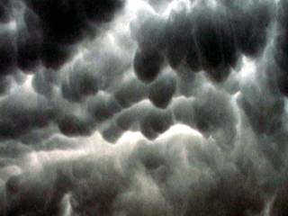
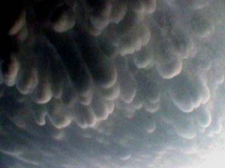
The mammatus display from the Concordia storm during its highpoint was the most impressive and surrealistic cloud formations I have ever seen. Note that the extreme mammatus in this picture looks more like the tentacles of a sea anenome rather that the typical women's breasts! |
|
Lights out! Power is knocked out in a small town north of Highway 36 from the massive inflow jets in excess of 60 MPH into the Concordia supercell updraft. |
|
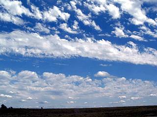
This is a picture of Altocumulus Castellanus (ACCAS) clouds high over eastern Kansas. Note the banding of the clouds caused by the extremely fast jet-stream winds aloft. This was just behind a wether system that caused tornado outbreaks across the Central US. |
|
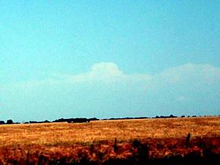
From east-central Oklahoma, a distant view of a supercell with an overshooting top can be seen just above the horizon. This shot is highly zoomed, and the thunderstorm is at least 100 or 150 miles away. Clear air behind the dryline allows such visibility. |
|
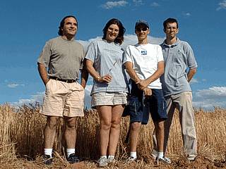
Here is our chase group, from left to right, myself (KG4PJN), Kersten Mcclung, Jeff Gammons (KG4PGA), and Jason Foster (N3PRZ). We are standing in a wheat field outside of Enid, Oklahoma. |
|
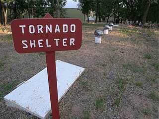
This is a picture of a large tornado shelter at a national park in Oklahoma. This shelter was about 40 feet long and 10 feet wide underground with two entrances on each side. The structures above the ground are three ventilation shafts. |
|
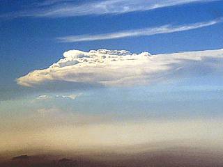
Here is a picture taken when flying out of Dallas / Fort Worth airport (to Fort Lauderdale, Florida) in a commercial Boeing 757 aircraft at an altitude of about 15,000 feet. A rock-hard overshooting top of an LP supercell thunderstorm can be seen welling up above the haze of the dryline. Dallas was in the center of a tornado watch at the time, and had storms with baseball sized hail nearby. The shadow in the foreground and lower left of the picture is an anvil shadow from another supercell's blowoff out of frame to the left. |
|
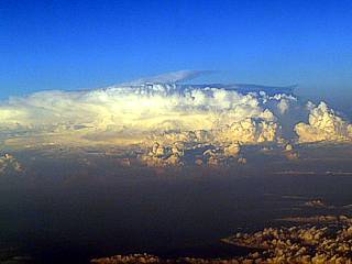
A multicell cluster of strong and severe thunderstorms over the extreme southeastern US (most likely FL, GA, or AL) can be seen from a Boeing 757 aircraft at an altitude of about 37,000 feet. |
|
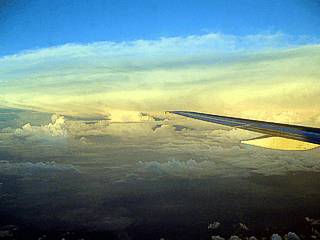
Finally over Florida, near Lake Okeechobee, our flight path takes us next to the sea-breeze convergence area and some majestic thunderstorm tops. The picture was taken from a Boeing 757 aircraft at an altitude of about 20,000 feet. |
During the late afternoon and evening of May 22, 2004, one of the most extreme tornado outbreaks occurred in southeastern Nebraska history. An over-sized violent supercell thunderstorm, more that 30 miles across and literally containing DOZENS of mesocyclones tore across Nebraska from east of Hastings to north of Beatrice. This storm was like no other, and produced at least six large tornadoes, many of them wrapped in precipitation.
During the latter part of that supercell storm's life cycle, the widest tornado in recorded history unfortunately took a direct hit on the small town of Hallam, Nebraska. This was a monster wedge tornado of F4 strength, with winds of 206 to 260 MPH, and a width of 2.5 miles (YES, TWO AND A HALF MILES WIDE)! 95 percent of Hallam was completely destroyed and most likely will never be rebuilt. Miraculously, few deaths occurred with the storm.
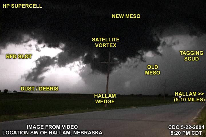
Above is an annotated picture of a video frame-grab taken 5 to 10 miles southwest of Hallam, Nebraska on May 22, 2004 at around 8:30 PM CDT. The possible wedge tornado can clearly be seen in this lightning illuminated picture.
|
Remnants of a two story home (picture taken with permission) on the southwest side of the town of Hallam, Nebraska on May 23, 2004 (24 hours after the tornado disaster). |
|
This is a pictue of myself while surveying damage on May 23, 2004 southwest of Hallam, Nebraska. I am standing on a slab once covered by a workshop (picture taken with permission) with the trucks inside deposited one on top of the other. |
|
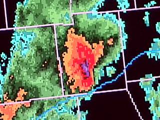
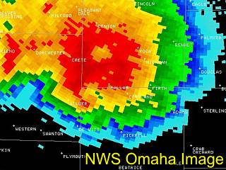
Radar image of the HP supercell thunderstorm taken at about 8:25 PM on Saturday, May 22, 2004, courtesy of the National Weather service in Omaha, nebraska. The supercell itself is a sight to behold, looking more like a hurricane eyewall than a thunderstorm (note the weaker reflectivity resembling an "eye" like feature in the center of the "doughnut" of high reflectivity). The small "hook" on the SE side of the "doughnut" is the Hallam 2.5 mile-wide tornado. |
Our chase team was on this storm when it was happening. The tornado was so large that it did not even look like the normal "wedge" tornado (at 2.5 miles wide, would it still even be called a "wedge")? Visually, only one side of a tornado was visible at a given time with the other edge of it too far away to see! Our chase team came within ONE MILE of this monster making a hasty retreat away from the outskirts of Hallam when we were greeted to a "wall" of fast moving lightning-illuminated clouds and a roaring sound. A damage survey of the town of Hallam the next day revealed a sobering and horrifying disaster area. Damage included homes completely disintegrated, trees uprooted and debarked, large projectiles (such as cars, couches, TV sets) carried great distances and deposited, even penetration damage from projectiles (impaling). This type of damage went from horizon to horizon ACROSS the tornado path (SE to NW). Arial surveys that day confirmed the unbelievable 2.5 mile width and 52 mile track. Authorities originally classified the damage as F3 but upped it to F4 later. Another interesting phenomenon also occurred when a canceled check from 1971 with the name "Hallam Bank" on it was found in Papillion, an outskirt of Omaha about 75 miles to the northeast of Hallam, only 28 minutes after the tornado hit the town!
This is something that storm chasers do not like to see, destruction of populated areas. Our sympathies go out to all victims of this disaster. The pictures below are in addition to the chase log pictures for this storm. Photo credits are to Jeff Gammons, Jason Foster, and Garry Wellman (arial surveys).
Each of the following resources can prove to be useful in the process of disaster mitigation and recovery, especially when it comes to large storm systems. A online bachelor degree in fire science can provide you with the insight needed to understand how to avoid the breakout of fires after a large storm or other natural disaster hits. A public relations masters programs can help you manage the disaster recovery aspect and distribute up to date information before and after a disaster hits. There is always a demand for medical help after a disaster, so completing a online rn to bsn programs is a good place to start if you are looking at becoming a nurse. And lastly, a Online Project Management Masters can be extremely useful in the rebuilding effort.
HTML File "mwcl2004.htm" - Developed By Chris Collura

My Contact Information Is Given In The Graphic Above
To Prevent SPAM And Abuse - The EMAIL Banner Above Only Links To My Information Page
For My EMAIL - You Will Need To Take It Down And Enter It In Your EMAIL Package
To Return To The HOME Page Of This Site Click The "INDEX.HTM" Link Here!