
| This page shows pictures taken during coastal observations of hurricane Michelle along the shores of South Florida on November 5, 2001. The storm was a major category 4 hurricane with 135 MPH winds that developed off Nicaragua, slammed into central Cuba, and moved southeast of Florida into the Bahamas during its weakening stages. The hurricane had a large field of gale forced winds on its NW side due to a strong high pressure area to the north of the area. As the system passed east of south Florida, strong winds from 30-35 MPH with gusts over 50 affected the area along with 10-15 foot waves and tides 1 to 3 feet above normal. This tropical cyclone was not directly intercepted. Pictures of the coastal observations and hurricane surf are in this area for viewing. |
|
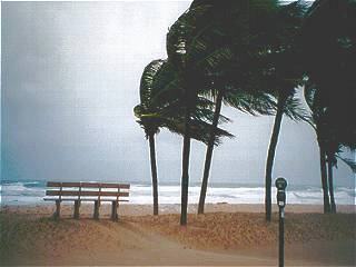
This is a picture taken during the early morning on November 5, 2001 during hurricane Michelle's closest approach to south Florida. This is Fort Lauderdale beach with winds blowing from the north and northeast (on the NW side of Michelle) at 35 MPH sustained. Gusts were as high as 60 MPH. Waves are confused and breaking up to 10 feet in the ocean. Note the wet sand covering the roadway and sidewalk in the bottom of the picture. |
|
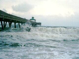
This is a picture of the fishing pier in Deerfield Beach, Florida taken during the morning of November 5, 2001 as hurricane Michelle was off the SE coast of south Florida. Even though the storm is moving away from the area, the strong winds kick up 8 to 10 foot waves causing coastal flooding and beach erosion. |
|
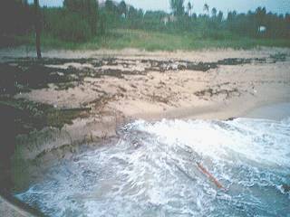
As hurricane Michelle passed to the east of south Florida on November 5, 2001, large surf and high winds caused erosion of many beaches. The beach here, Boynton Beach in Palm Beach county, is heavily eroded and the heavy surf is filled with debris and drift wood. The dark "leaves" covering the beach, or what's left of it, is seaweed. |
|
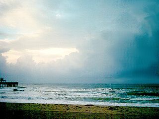
This is a picture taken at Deerfield Beach, Florida during the early evening on November 5, 2001 as hurricane Michelle was moving away from the area through the Bahamas. Seas have calmed down considerably but outer convective bands from the system still are affecting the area. A strong trough of low pressure aloft is steering the storm away from Florida, but increasing vertical shear above the convective showers still in the area. Some isolated tornadoes were produced by "mini HP supercells" that developed with the feeder bands. Note the rain free base in the middle to right of the picture over the ocean. Note the upper level winds blowing the storm tops to the right (south). |
HTML File "michel01.htm" - Developed By Chris Collura
To Return To The HOME Page Of This Site Click The "INDEX.HTM" Link Here!