
| This area shows pictures taken from the interception and penetration of tropical storm Marco in Sarasota county on the Florida west coast in October 11, 1990. This storm contained sustained winds of 65 to 70 MPH with higher gusts, just shy of a minimal hurricane. The storm formed near Cuba and moved north making landfall on the barrier islands south of Tampa Bay. |
|
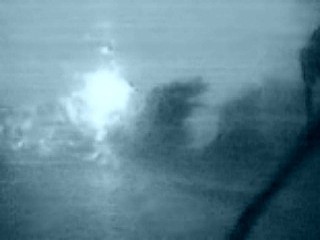
Before sunrise on October 11, 1990 heading westward through Sarasota county on the Florida west coast, the main convection is penetrated east of the storm's eye. In this picture, photographed using a flash of lightning at about 5:00 AM, shows the torrential rains and winds gusting over 70 MPH as depicted by the trees. The bright flash in the picture is a power flash as a powerline is taken out by the storm. This region of deep convection near the storm's core is known as a convective chimney or primary energy cell. |

|
Inside the eye of tropical storm Marco along the beach in Sarasota at sunrise on October 11, 1990. Winds here are calm and the blue sky can be seen through the storms eye as the sun rises. A WC 130 Hurricane Hunter Air Force plane was also circling overhead before this picture was taken. The deep convection is behind me as this view is looking south. |
HTML File "marco90.htm" - Developed By Chris Collura

My Contact Information Is Given In The Graphic Above
To Prevent SPAM And Abuse - The EMAIL Banner Above Only Links To My Information Page
For My EMAIL - You Will Need To Take It Down And Enter It In Your EMAIL Package
To Return To The HOME Page Of This Site Click The "INDEX.HTM" Link Here!