
| This area shows pictures taken from the interception of the weak circulation center of tropical storm Jerry on August 23, 1995 in Palm Beach County, Florida. The tropical storm had maximum winds of about 45 MPH as it made landfall in Palm Beach County. The biggest effects from this storm were extremely heavy rains. Some pictures of the center of TS Jerry can be seen in this area of my web site. |
|
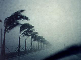
This picture was taken in Palm Beach County, Florida, on August 23, 1995. Strong SW winds and torrential rains pummel the area as the center of tropical storm Jerry makes landfall. This storm had 45 MPH sustained winds, with some gusts to 60 MPH, as shown here. The storm also dumped at least 10 inches of rain in less than 24 hours. The developing storm weakened after making landfall over central Florida. This picture was taken under the main convective cell near the center of the storm. |
|
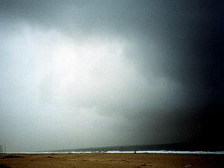
The winds let up a bit and clouds become thinner in the center of tropical storm Jerry as it comes ashore in Palm Beach County, Florida during the afternoon of August 23, 1995. Here, the winds are light from the south with only light rain falling. This is the very beginning of a subsident (sinking air) region that occurs in the centers of warm-cored (tropical) cyclones. The main convective "chimney", which surrounds this region, is to the right of this picture (which is looking NE). At this time, the storm had maximum sustained winds of 45 MPH and was intensifying up until landfall (it was only a 35 MPH depression 4 hours earlier). |
HTML File "jerry95.htm" - Developed By Chris Collura
To Return To The HOME Page Of This Site Click The "INDEX.HTM" Link Here!