
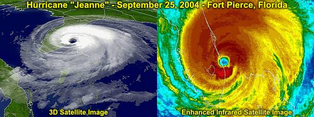
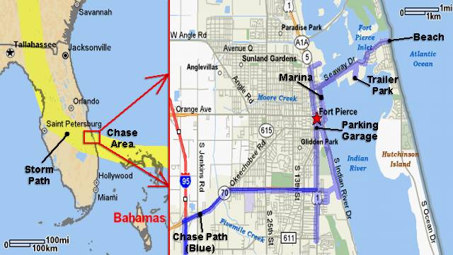
| This area shows pictures taken from the observations of yet another category-three hurricane Jean in Fort pierce, Florida (Yes, Fort Pierce - The same city ravaged by hurricane Frances just three weeks prior). This storm packed 120-MPH sustained winds with higher gusts as it made landfall very close to the same location as Frances did. As with many other storms during this exceptionally active season, this storm began as a tropical disturbance that moved off Africa. The storm moved over Hispanola (Haiti and the Dominican Republic) as a minimal hurricane and caused flash floods that killed over a thousand people in Haiti alone. The storm weakened and meandered north of the caribbean and even did a "loop" in the weak steering flow. Finally, the storm locked into the flow of a building high-pressure area and began moving west again, gaining strength. Hurricane Jeanne continued west and made landfall in East-Central Florida during the night of September 25-26, 2004. The storm was intercepted in Fort Pierce, Florida with winds over 120-MPH and a central pressure measured in the northern portion of the 40-mile wide eye at 954 MB. This hurricane interception also included extreme storm surge footage, winds gusting over 120-MPH, and about an hour wait in lighter winds while taking measurements inside the northern edge of the eye of the storm near Fort Pierce. The eyewall weather was spent in a reinforced parking garage inwhich portions of became an incredible wind tunnel! The entire chase was from September 25 through September 26, with about 280 total miles logged. Note - This page may take a while to load on some SLOWER connections! |
| CHASER NAME | HOME CITY | CALLSIGN | OCCUPATION |
| CHRIS COLLURA | MIRAMAR, FL | KG4PJN | COMPUTER ANALYST |
| DOUG KIESLING | MINNEAPOLIS, MN | N/A | BNVN PRESIDENT |
| JASON FOSTER | BALTIMORE, MD | N3PRZ | ARCHITECT |
| JEFF GAMMONS | WPB, FL | KG4PGA | PHOTOGRAPHER |
The participant(s) below are not from the former "Weathervine", SKY-CHASER, or BNVN chase team(s) but did actively participate in our storm research efforts and deserve appreciation for their great help and severe weather expertise.
| CHASER NAME | HOME CITY | CALLSIGN | OCCUPATION |
| JIM EDDS | FLORIDA KEYS | KG4TBE | PHOTOGRAPHER |
|
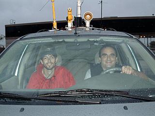
Here is a picture of the front of my chase vehicle, a 2004 Ford Focus, with equipment on top. I am driving and Jason Foster (N3PRZ) is in the passenger seat. This was before hurricane Jeanne was moving into Fort Pierce. |
|
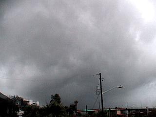
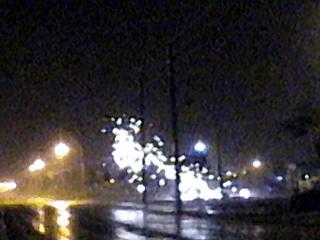
Increasing speed and directional shear in the low levels allow for some small rotating updrafts to develop ahead of the hurricane in its forward-right side. A small HP supercell, smaller and shallower than its springtime Great Plains cousins, develops near Fort Pierce in this picture and races southward. Note the "RFD Slot" to the far left and slight inflow / updraft banding (right and towards the center of picture). A radar-indicated tornado warning was issued for this storm shortly after this picture was taken. This is why tornado watch boxes are issued for the areas affected by the right-front quadrant of a tropical cyclone. |
|
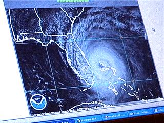
Here is a picture of Jeff Gammon's (KG4PGA) laptop computer with an all-to-familiar satellite image of major hurricane "Jeanne" bearing down on the East-Central Florida coast, right were we were at (and wanted to be) at the time! |
|
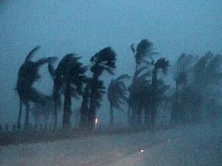
Some palm trees thrash in the twighlight near the Fort Pierce boat ramp as hurricane Jeanne's stronger winds move in. |
|
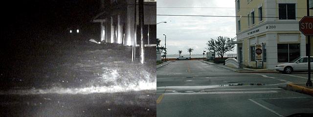
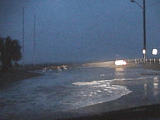
Storm surge starts to overrun the sand dunes just south of Fort Pierce Inlet during the evening prior to arrival of the core of the hurricane and spills into the street (time to go). |
|
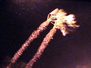
Here is a picture of two tall palm trees bending in near hurricane force winds just after dark along highway US 1 in Fort Pierce, Florida. |
|
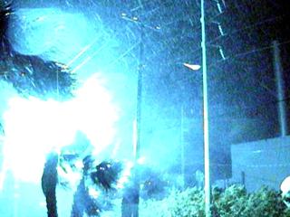
This is a bright power flash caused by strong winds taking out powerlines. The powerlines either touch together or ground out causing a short circuit and tremendous power arc. This is near the Fort Pierce power plant. |
|
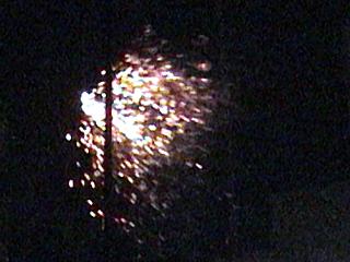
A second or two after the above picture, a shower of sparks flies across the street after the power flash melts the wires. |
|
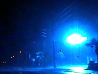
This is another bright power flash along highway US 1 in Fort Pierce as strong winds taking out more powerlines. |
|
A second or two after the above picture, another shower of sparks flies across the street after the power flash melts the wires. |
|
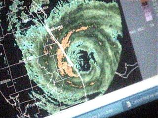
Now hunkering down in a reinforced concrete parking structure, Jeff's laptop computer paints an ominous eyewall image as he pulls down some last data frames from the Melborne, FL radar site. The meanest and reddest portion of the eyewall is crossing the coast at our location (Fort Pierce) on the radar image. |
|
The parking garage entrance to the roof (to the left in this picture) allowed for some eyewall winds to ram through the structure, reaching at least 120-MPH. In this picture, the violent (sideways) rain can be seen blowing from left to right. This actually became a "wind tunnel" allowing some daring members of our chase team to sample category-three winds! |
|
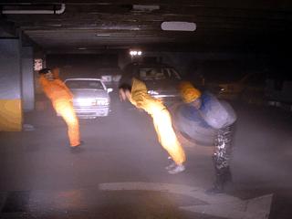
Here is a picture (video frame-grab), taken with the video camera enclosed in the "surgecam" waterproof case, of Doug Kiesling, Jim Edds, and Jason Foster being blasted by winds over 100 MPH inside a Fort Pierce parking garage. The winds entered the entrace to the top level of the garage roof creating a wind-tunnel effect. Note Doug's orange raincoat (leftmost person) tearing by the force of the wind. |
|
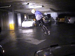
Hurricane chaser Jim Edds (KG4TBE) gets blasted by 120-MPH winds in the parking garage. Jumping into the air caused the wind to literally pick you up and blow you back. Jim is a couple of feet off the floor in this picture! |
|
Here is a another picture of Doug Kiesling, Jim Edds, and Jason Foster being blasted in the Fort Pierce parking garage just ahead of the garage top level entrance. Winds before the eye were out of the north. |
|
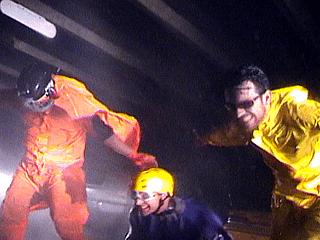
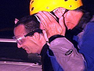
Check out the faces of myself and Jim Edds (the one with the yellow crash helmet) in this picture taken by Jeff Gammons. Note the distortion of my face by winds gusting near 120 MPH. |
|
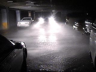
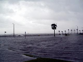
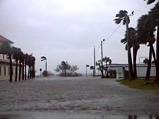
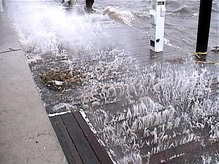
Storm surge severely floods downtown Fort Pierce during the height of hurricane Jeanne. Note that the waves in this picture are breaking across a street and the front of buildings! Just moments earlier, we were driving along this street (Indian River Drive) that is now under many feet of salt water. Winds here are also gusting over 115 MPH. |
|
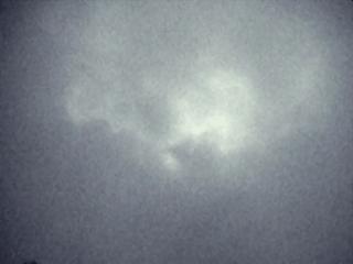
Here is a picture of breaks in the clouds in the eye of hurricane Jeanne, revealed by a full moon. Winds here were less than 20-MPH with NO rain. We were in the northern part of hurricane Jeanne's eye. |
|
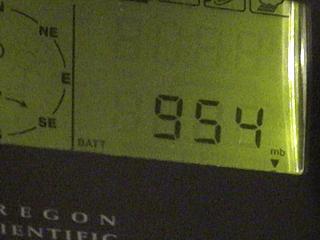
Barometric pressure is lowest in the eye of the storm. In this picture, the barometer of my Weatherlab weather station (Oregon Scientific WM-918) bottoms-out at 954 MB. The relative calm of Jeanne's eye was soon replaced by 115-MPH+ winds from the south. |
|
Daylight the following day only revealed the extent of the damage and flooding. In this picture, a parking lot and church near the waterfront are flooded by 5 to 10 feet of salt water, which is slowly retreating after the storm. |
|
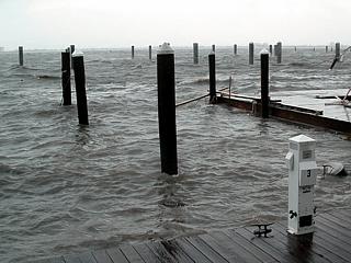
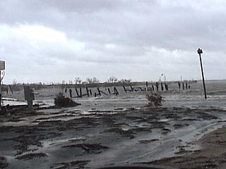
The Fort Pierce marina also was a major target for hurricane Jeanne. Severely damaged in Frances three weeks prior, whatever docks and boats were spared simply disappeared in Jeanne. Note that there are only pilings in this picture, no floating docks and no boats! |
|
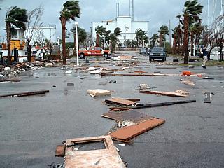
The parking lot at the Fort Pierce marina was strewn with boat debris and supplies after hurricane Jeanne's passage. Note that most of the debris is teak (wood used on boats), seaweed, and boating supplies such as fuel cans and tools. |
|
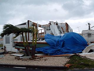
Here is a picture of severe damage to a mobile home in a trailer park that was also damaged by Frances a few weeks prior to being "finished off" by hurricane Jeanne. |
|
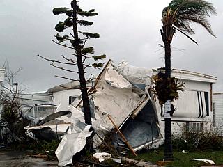
Here is another picture of major structural damage and tree damage after the passage of hurricane Jeanne in a Fort Pierce trailer park. |
|
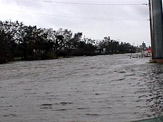
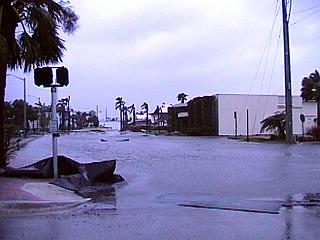
Severe street flooding in Fort Pierce near Indian River drive. This flooding is BOTH fresh rainwater and salt-water storm surge. |
|
Here is another picture of severe street flooding in Fort Pierce the morning after hurricane Jeanne due to storm surge. |
|
Here is another picture of severe street flooding in Fort Pierce from the storm surge. Water like this often takes time to recede. |
|
This is the picture of the south side marina and dockage area of the trailer park in Fort Pierce near the beach causeway. The marina and docks have been totally destroyed. |
|
Huge waves overtake the remnants of the Fort Pierce Marina and smash under the dockings that were spared. |
|
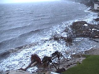
Here is a picture of the Indian River (Fort Pierce Bay). This is NOT the ocean, as one may think from the size of the waves. Water level is still high and destructive hours after the storm. Note the damage along the bayfront. |
HTML File "jean04.htm" - Developed By Chris Collura
To Return To The HOME Page Of This Site Click The "INDEX.HTM" Link Here!