
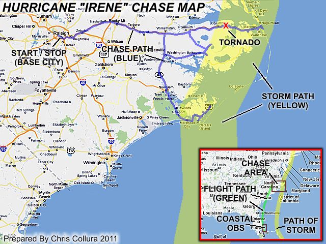
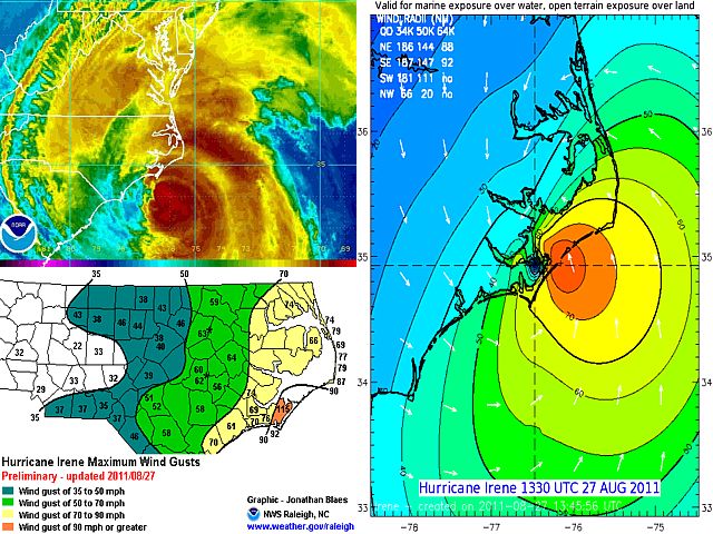
| This area shows the interception of hurricane "Irene" in late August of 2011, particularly from August 25 through August 28, with the main observations being August 25 (in Florida) and August 27 (in North Carolina). Irene originated from a tropical wave that came off of Africa (Cape Verde system) and developed just east of the Windward Islands. It became a tropical storm near Saint Croix and intensified as it passed over Puerto Rico on August 22. The storm became a hurricane north of the Dominican Republic on August 23 and entered the Bahamas, intensifying to major hurricane status on the 24th with winds from 115 to 120 MPH. Hurricane Irene moved over the Bahamas as a major hurricane on August 24th and 25th as it made it's recurve to the north during the latter part of that time frame. Large and destructive swells affected the east coast of Florida, and were not blocked very well by the Bahamas "wave shadow". On August 26, the storm weakened slightly (to 110 MPH) as it headed due north, taking aim on the North Carolina coast. Hurricane Irene made landfall near Cape Lookout, North Carolina early on August 27 as a borderline Category 1 / 2 storm with winds near 100 MPH. Irene continued north that same day across the Pamlico Sound of NC and partially re-emerged near the Virginia / North Carolina coasts during the evening of August 27, with winds near 85 MPH. As a weakening hurricane, Irene continued north, skirting the coast, and accelerated into the vicinity of New York on August 28. The storm weakened to a tropical storm later that day, and became extra tropical over Maine on the 29th. Hurricane Irene caused at least 43 deaths and over 10 billion dollars in damage. In this chase log, my interception and observations of hurricane Irene is shown in detail (in Florida and North Carolina). Note - This page may take a while to load on some SLOWER connections! |
| CHASER NAME | HOME CITY | CALLSIGN | OCCUPATION |
| CHRIS COLLURA | SUNRISE, FL | KG4PJN | COMPUTER ANALYST |
| JASON FOSTER | BALTIMORE, MD | N3PRZ | ARCHITECT |
| MARK ELLINWOOD | BALTIMORE, MD | N/A | STUDENT |
The list above shows personnel who actively participated in this chase, including myself. After observing the effects of the hurricane locally in Florida (mainly high surf and rain squalls) on August 25, I flew into Raleigh, North Carolina late on August 26 to make the primary target near Morehead City by early August 27. I wrapped up the intercept late on the 27th near Nags head and met up with Jason Foster (and his chase partner Mark Ellinwood) near Columbia, NC after they had some car trouble with their vehicle. They shared my ride back to Raleigh, NC for the night. I flew back to FL on the morning of August 28 and Jason and Mark rented a car and drove back to Maryland that same day with arrangements to have their vehicle repaired later.
|
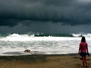
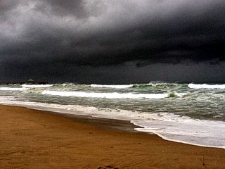
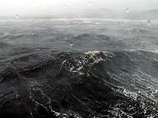
Hurricane Irene's closest approach to south Florida was during the afternoon of August 25 when it was over the Island of Abaco in the Bahamas, a bit less than 200 miles to the east. The western portions of this very large tropical system still affected the east coast of southern Florida, particularly Palm Beach and northern Broward Counties. In this picture, very large swell-waves from the ESE have made it through the New Province channel of the Bahamas, which normally block hurricane swells from reaching south Florida. The dark shelf cloud in this picture (taken near Deerfield Beach, FL) is associated with an outer feeder band of hurricane Irene, and contained very heavy rains and wind gusts to 50 MPH. |
|
Here is another picture of the hurricane surf affecting Deerfield Beach, FL with the ominous rain band looming overhead and about to move onshore. The strong southeast swell, up to 12 feet in height, is also causing beach erosion. |
|
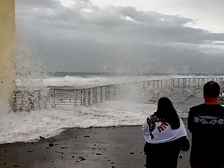
Spectators watch the crashing waves on the north jetty at Boynton Inlet near Boynton Beach in Palm Beach County, FL. This is just after a rogue wave slammed the jetty sweeping people off their feet, and injuring at least five of them. |
|
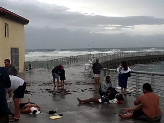
Dazed and confused injured people awaiting help from lifeguards on the north jetty after a large rogue wave swept them off their feet. |
|
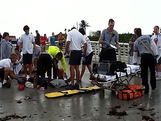
Paramedics arrive and place the most seriously injured victims of the rogue wave on stretchers and prepare them to be airlifted to a hospital in Palm Beach County. The most serious injuries were a broken neck and severe blunt trauma as the wave pushed them into rocks / structures near a sand pumping station on the north side of the jetty. |
|
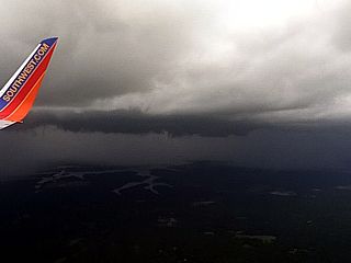
Here is a picture taken from a Boeing 737 on final approach into Raleigh-Durham Airport in North Carolina during the late afternoon of August 26. The sky to the southeast is ominous with an outer feeder band affecting the southern portions of the Raleigh area. |

|
Here is a picture of my vehicle in a parking lot outside of a church near Smyrna, NC, which is east of Beaufort along Highway 70 as the worst conditions of hurricane Irene move in after sunrise. Winds here are hurricane forced and gusting near 90 MPH. |
|
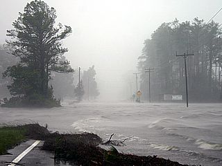
This is the view looking east of Smyrna, NC alogn Highway 70, now impassible with rising storm surge water and winds gusting over hurricane forced. |
|
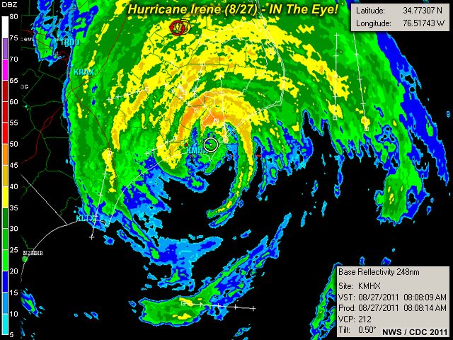
The calm eye of hurricane Irene passes over, and the winds die down quickly to near calm. The water level, however, remains chaotically high in the eye of a hurricane (just without the whipping winds). I measured 970 mb at this time, while the NHC and a automated station just to my SW reported a pressure of 952 mb. |
|
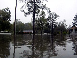
Here is a picture of another flooded residence near Smyrna, NC with a mirror-like calm water reflecting the sky in the calm eye of hurricane Irene. The eye was very calm, but not visually clear as a low stratus deck / drizzle persisted inside the eye of the hurricane. |
|
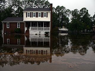
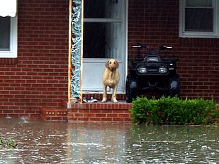
A golden retreiver dog waits patiently on the stoop of a flooded residence between Smyrna and Beaufort. Light drizzle is falling, but this was still in the calm eye of hurricane Irene. Flooding (from both salt water / storm surge as well as fresh water from well over a foot of rain) was very severe and the main cause of devastation from this storm, aside from wind gusts over 100 MPH. |
|
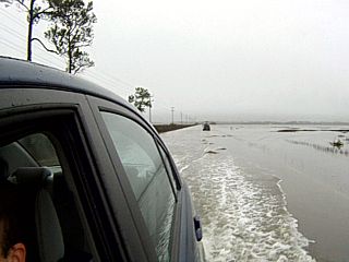
Here is a picture of myself and my vehicle trudging through miles of flooded roadway enroute to leave the Beaufort, NC area and head back north along Highway 70. This was the most un-nerving part of the hurricane chase. At one point, water was coming OVER the front hood of the vehicle! |
|
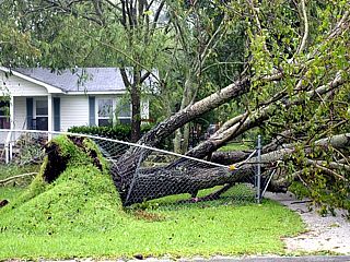
A large tree was blown down and on top of a fence, destroying it, near Highways 17 and 70 on the western side of hurricane Irene. Winds were very strong from the north after leaving the calm eye of hurricane Irene, and caused many downed trees / powerlines along Highway 17. |
|
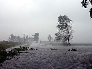
Here is a picture of some severe fresh water flooding in the farming areas in and around Highway 264 and near Pantego, NC. The attempt was to travel back north and east towards Highway 264 and eventuially Highway 64 for a "second" intercept of hurricane Irene's core on the north side of Pamlico Sound. This trip was not easy, with many detours around flooded roads and downed trees. |
|
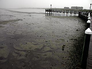
Here is a picture of a marina / dock area on the north side of the Pamlico Sound and west side of Nags Head, NC. With winds blowing near hurricane-forced from the southeast, the flow here is offshore, and resulting in a NEGATIVE storm surge (water pushed OUT into the bay, rather than onshore). The negative surge is similar to a pre-tsunami "drawback" of water, exposing the bare bottom of the bay, with even some flopping fish / tilted-boats without any water! |
|
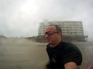
Weather Channel meteorologist Mike Sidell stands in hurricane-forced winds gusting near 80 MPH at the beach in Nags Head, North Carolina as the eye of hurricane Irene passes just to the west. |
|
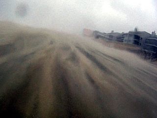
Here is a view of the sand-blasting effects at the beach in Nags Head, NC. Winds are racing from the southeast ahead of Hurricane Irene in the Pamlico Sound just SW of me. This sand causes physical pain, like many needles, and even leaves small cuts in your exposed skin. |
|
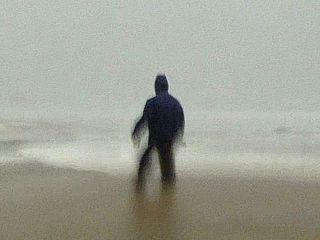
Here is a picture of myself being blasted by hurricane forced SE winds in Nags Head, NC along the beach. |
|
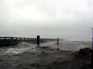
Large waves in the Pamlico Sound and just north of the Highway 64 bridge. The unique view is looking down from the north side of the causeway bridge in 80 MPH winds. |
|
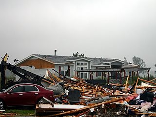
Hurricane Irene spawned a few tornadoes during the late night and early mornig hours of August 26-27. One of the strongest of the tornadoes caused extensive damage east of Columbia, NC along Highway 64. The destructive tornado was caused by a TCMS (tropical-cyclone mini-supercell) embedded in a feeder band ahead of the storm's forward-right quadrant. Normally these supercells, and tornadoes associated with them, are weaker than their spring-Midwestern cousins ... But in this case, there appears to be an exception to that. |
|
More large waves near Manteo, NC and along the Pamlico Sound crashing into a jetty. Note the downed powerline to the left and high water level nearly overtopping the Highway 64 causeway. |
HTML File "irene11.htm" - Developed By Chris Collura
To Return To The HOME Page Of This Site Click The "INDEX.HTM" Link Here!