
| This area shows pictures taken from the interception and observation of hurricane Igor in the island of Bermuda during the period of September 18-21, 2010. This tropical cyclone was an intense Cape Verde type system, originating from a tropical disturbance over Africa, which at one point reached strong category-4 (155 MPH) strength while over the tropical Atlantic. The storm recurved out to sea and weakened to category one (85 MPH winds), with the center passing just west of Bermuda during the night of September 19-20. Igor had an extremely large wind field of hurricane forced winds, with a massive gale (tropical storm forced) wind envelope surrounding that. Bermuda, being the only land affected by Igor, was also exposed to the right front quadrant of the hurricane core, with gusts on some of the higher points over 101 Knots (116 MPH). To chase this hurricane, it required a last-minute flight out of Fort lauderdale, Florda and to Bermuda (connecting in Atlanta) on September 18. I arrived in Bermuda just before the airport closed with 30-40 MPH winds already affecting the area. The main interccepts / observations were on September 19 and 20, with much of the hurricane conditions arriving on the 19th long before dark. High waves and some minor wind damage was noted, with many boats damaged / run aground. The airport re-opened on the 21st, and I returned to Florida later that day. |
| CHASER NAME | HOME CITY | CALLSIGN | OCCUPATION |
| CHRIS COLLURA | SUNRISE, FL | KG4PJN | IT CONSULTANT |
| PAUL MICHELSON | NEWARK, NJ | N/A | IT MANAGER |
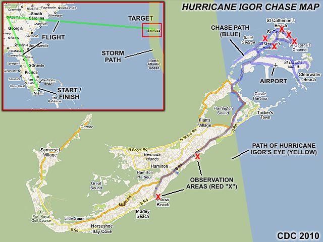
The graphic above is a chase map for the interception of hurricane Igor in Bermuda. This intercept was an international chase, requiring leaving the United States via a flight from (and returning to) Fort Lauderdale, Florida to Bermuda (with a connection in Atlanta, GA). My arrival was about 2:30 PM AST on Saturday, September 18, only an hour before the airport was closed. Once on the island, choosing an area was important as transportation there is limited (you CANNOT rent a car in Bermuda). St George was my "base" there (at Anne Nea's guesthouse) and was within walking distance of the east-facing beaches and also east-most in the event hurricane Igor passed east of the island. The south shore (such as Elbow Beach) required a cab ride before conditions deteriorated. I was also able to get a ride around town after the storm - Thanks to two great locals that myself and chaser Paul M ran into near Tobacco Beach (thanks to all who made this happen). Bermuda is a very diffucult place to chase in. The yellow swath in the diagram shows the path of the storm core (pressure center) across Bermuda. The blue lines are the chase / observation "tracks".
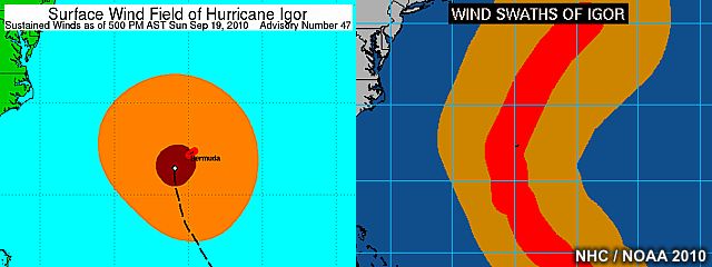
In the graphic above, we see an image of the surface wind field of hurricane Igor, just before the core windfield affected Bermuda on September 20 to the left as well as the wind "swath" of the storm to the right (images courtesy of the National Hurricane Center). The immense size of hurricane Igor's wind envelope (with the tropical storm forced winds alone extending across a diameter of over 850 miles) subjected Bermuda to a long period of strong winds and high waves. The storm also weakened from category 2 to category 1 because of the large sinze of the storm upwelling water ahead of it (common with such large hurricanes). The storm center also "jogged" west a bit, placing Bermuda in the dangerous right-side of the storm.
|
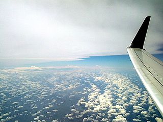
Here is a picture of the marginal area (western edge of the hurricane) viewed from about 35,000 feet while en-route to Bermuda (the flight was from from Atlanta, GA in the United States). The banding in the lower levels and distinct cirrus "shield" can be seen in this picture. The view is looking southeast while over the ocean roughly 200 miles west of Bermuda. Tremendous southeasterly swells could also be seen looking down from this vantage point (exceeding 20 feet in height). |
|
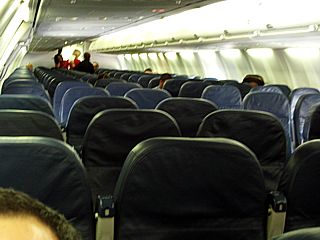
This is a view of the inside of the plane (a Boeing 737) en-route to Bermuda from Atlanta, GA in the US. This is it, a mere handful of passengers and crew are on the plane! When traveling to a region affected by a hurricane, 99% of the people are moving OUT (not into) of the "target" area. Sometimes flights this empty are not cost-effective and are simply cancelled. Luckily (for me) this one wasn't. |
|
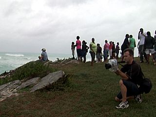
Once in Bermuda, the first are of observation was Elbow Beach, where many storm chasers and locals gathered to observe the huge waves crashing into the rocks (the beach is below limestone bluffs). I beleive that is George Kouranis from Toronto, Canada taking pictures to the right? A southeast swell, about 20 to 30 feet high, was breaking miles offshore. |
|
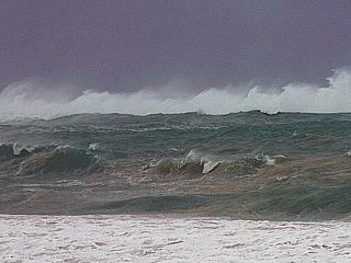
This is a view of the ocean to the southeast of Elbow Beach a day before the arrival of hurricane Igor (late on Saturday, September 18). The waves (southeast swell) breaking on the reef (about a mile out) are at least 30 feet high. |
|
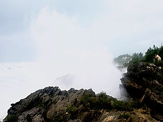
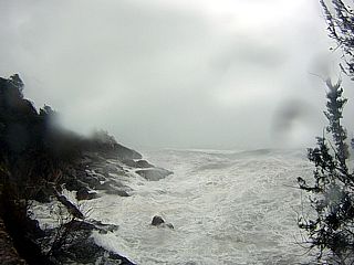
Huge waves crash into the limestome bluffs near Elbow Beach on the south shore of Bermuda. The violent hurricane surf (southeast swell at least 30 feet high) preceding the storm crashes into the rocks sending spray nearly 100 feet in the air. Chaser Jeff Piotrowski (taking pictures) is drawfed to the far right. |
|
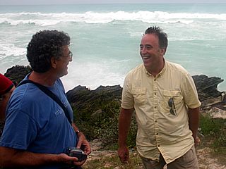
Here is a picture of hurricane chasers Paul M (left) and Jeff Piotrowski (right), each from New Jersey and Oklahoma, respectively. The last time I saw Jeff Piotrowski was in South Dakota in May 2010 ... Showing how numerous storm chasers can "converge" in one area regardless of location. At least 7 veteran storm chasers went to Bermuda to chase hurricane Igor. |
|
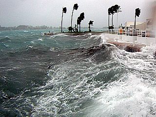
Large waves better the relatively protected lagoon near the main center of St George. This lagoon is roughly a mile or so across, but is suseptible to storm surge (it is connected to the ocean by inlets) and wave action when winds exceed 70 MPH. |
|
Here is a picture of the hurricane surf conditions on the east-facing areas east of Tobacco Bay in Bermuda as hurricane conditions arrived on the island on September 19 (Sunday). Huge wind-driven waves and spray make the normally tranquil ocean white. |
|
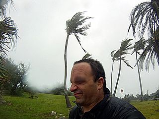
This is a picture of myself with palm trees blowing (taken from a waterproof GoPro Hero camera) as hurricane forced winds arrived at the island. |
|
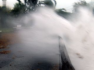
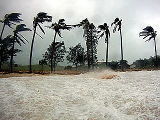
Large waves and storm surge, driven by wind gusts exceeding 80 MPH, crash over the roadway on the eastern side of Bermuda east of Tobacco Bay. |
|
Here is a view of the beach near St Caterine's Fort as hurricane conditions drive a storm surge and high waves with debris to the roadway. |
|
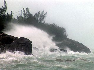
This is another pciture of some of the limestone bluffs near Tobacco Bay as huge waves crash against the rocks sending spray high into the air. |
|
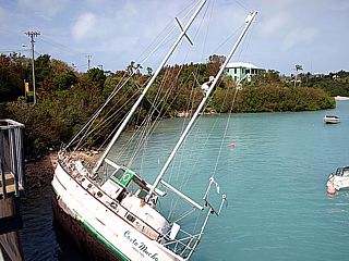
This is one of several large sailboats that came to rest on the edge of the St Georges lagoon. This large boat jammed itself against a small drawbridge during the height of the storm on September 19-20. |
|
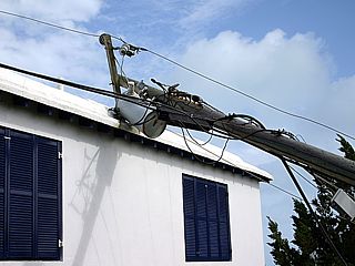
Here is a downed power pole and transformer that crashed down on a house near St Davids. |
|
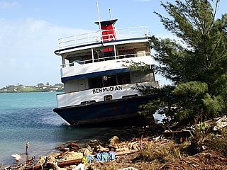
Here is a picture of a large ferry boat that washed ashore near the St Davids dockyard. |
HTML File "igor10.htm" - Developed By Chris Collura

My Contact Information Is Given In The Graphic Above
To Prevent SPAM And Abuse - The EMAIL Banner Above Only Links To My Information Page
For My EMAIL - You Will Need To Take It Down And Enter It In Your EMAIL Package
To Return To The HOME Page Of This Site Click The "INDEX.HTM" Link Here!