
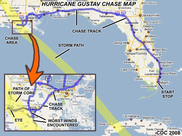
| This area shows pictures taken from the interception and observations of hurricane Gustav in southwestern Louisiana from August 31 through September 2, 2008. Gustav was a major hurricane with sustained winds ranging from 110 to 115 MPH as it made landfall during the mid-morning of September 1, 2008 and was intercepted near Houma, Louisiana near the Terrebonne / Bayou Parishes. Gustav formed as a typical Cape Verde disturbance off the African coastline and became a strong tropical depression, then a strong tropical storm (very quickly) in the Eastern Caribbean. The storm then began a tumultous track across the southwestern portions of Haiti (where it briefly became a hurricane), then across Jamaica. The storm continued northwest and re-gained hurricane strength near the Cayman Islands on August 29. Gustav then began it's track towards Cuba, while explosively deepening to an inpressive 150-MPH storm with a central pressure of 938 MB. The storm crossed Cuba early on August 30 and emerged into a rather less-favorable environment in the Gulf of Mexico. On August 31, the storm continued to the NW, and strengthened from 100-MPH (lost from its pass over Cuba) back to 120-MPH. Gustav continued to the NW on September 1, making landfall near the Terraboone Parish in Louisiana at about 10 AM CDT with 110-MPH winds and a central pressure of 957 MB. Gustav continued inland, and weakened near Baton Rouge to a category 1 storm, then weakened to a depression a day later on September 2 to a tropical depression (dissapating over SW Arkansas that same day). The chase went very well, leaving Miami early on August 31 and arriving in the primary target (Morgan City, LA) by near midnight (Sept 1). The intercept was for most of the day on September 1, with a return to Miami on September 2. Extensive damage was observed near the landfall point with penetration into the calm eye of the storm documented. Note - This page may take a while to load on some SLOWER connections! |
| CHASER NAME | HOME CITY | CALLSIGN | OCCUPATION |
| AARON DEBRUIN | GAITHERSBURG, MD | KB3RAE | STUDENT |
| CHRIS COLLURA | MIRAMAR, FL | KG4PJN | COMPUTER ANALYST |
| JASON FOSTER | GAITHERSBURG, MD | N3PRZ | ARCHITECT |
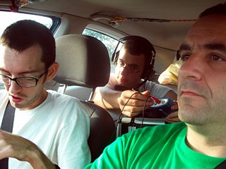
The list above shows personnel who actively participated in this chase, including myself. Jason Foster was my back-up driver and chase partner, and Aaron DeBruin was a storm-chase apprentice who was a ride-along with us. Aaron is also a meteorology student. The chase vehicle was a 2007 Ford Focus. Jason and Aaron flew into Miami and met up with myself on August 30, and left for the target (SW Louisiana) area very early on August 31. The main chase was September 1, with a wrap up and overnight stay in Pensacola, Florida dropping Aaron off at theairport there, and with Jason and myself returning to Miami on September 2. Jason stayed in Miami a day later on September 3 but returned to Maryland on september 4.
|
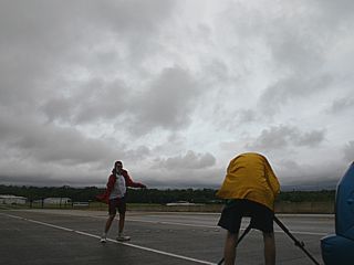
Here is a picture of myself (to the far right) and my hurricane chasing group. We traveled from Miami to Louisiana in rather cramped quarters with gear and equipment in my 2007 Ford Focus. To the far left is Jason Foster (N3PRZ) and in the rear seat is Aaron DeBruin (KB3RAE). We are actually streaming audio and some video via Sprint / AT&T wireless internet! |
|
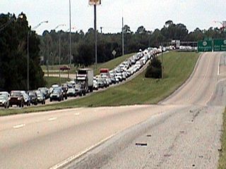
Here is a picture of Interstate 10 west of Pascagoula, Mississippi a day before Hurricane Gustav's arrival on August 31, 2008. The impressive evacuation traffic jam is on the eastbound lanes, headed away from the landfall area of the storm, especially New orleans, where two MILLION people were evacuated. Note our west-bound route, without a single vehicle headed west, to the right. Law enforcement and other storm chasers made up most of the scant traffic headed INTO the "danger area". |
|
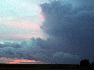
This is one of the tornado-warned "mini" supercell storms ahead and to the right of hurricane Gustav near Vacherie, Louisiana during the evening of August 31, 2008. The storm here is called a TCMS (Tropical-Cyclone Mini-Supercell) and if you look closely (bottom of picture) at the storm base you may see the funnel clouds associated with the updraft base of this small supercell (developing in one of the outer feeder bands of hurricane Gustav). |
|
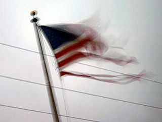
A flag becomes tattered during the on-set of hurricane-forced winds in Houma, Louisiana just after sunrise. |
|
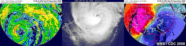
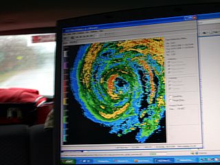
Looking at the radar image, the ominous "doughnut" of hurricane Gustav's core appears on the NWS radar site. The eye is clearly visible. |
|
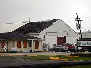
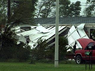
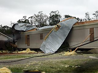
Many structures near Houma, Louisiana (in the Terrabonne Parishes) suffered extensive damage, such as a roof completemy torn off this building. Winds gusting near 110-MPH were encountered in teh eyewall of hurricane Gustav as it made landfall during the late-morning of September 1, 2008. |
|
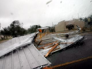
In this picture, debris and mangled metal / roof material can be seen sliding across the highway south of Houma, Louisnaia. I do NOT recommend driving through a hurricane like this without experience (and luck). |
|
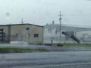
Sheet metal flies through the air on the south side of Houma, Louisiana as hurricane Gustav's eyewall comes into the area with 110-MPH winds. |
|
Here is a picture of some more mangles sheet metal in a trailer park to the south of Houma, Louisiana. damage to mobile homes in this area was extensive. |
|
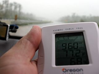
The barometric pressure was continually monitored throughout the chase of Gustav. In this picture, near the eye of the hurricane, a low pressure of 960 MB can be seen. The lowest pressure encountered was 959 MB, also inside Gustav's eye. |
|
Jason Foster and Aaron DeBruin experience the calm winds and brighter skies inside the eye of hurricane Gustav near Morgan City, Louisiana. |
|
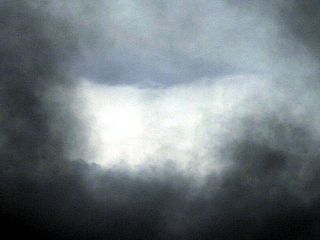
Looking up at the edge of hurricane Gustav's eye, a brief break in the lower clouds reveals the distinct curved eyewall and patch of blue sky overhead! The curve of the eyewall forms a portion of the "stadium effect" that is noted frequently by hurricane-hunter aircraft. |
|
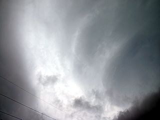
Another interesting feature noticed inside the eye of hurricane Gustav was this spiral cloud formation (to the center and right of this picture). Note the striations of the rotating cloud, and clear "slot" / swirl to its left. This was actually a portion of the convective "chimney" of the storm, which is essentially a large thunderstorm updraft with an attendant meso-vortex extending into the eye of the storm, creating the striated "supercell-like" appearance. |
|
The second half of hurricane Gustav (on the southern side of the eye) was not as bad as the first half, mainly because the storm was over land and weakening. In this picture, a roof from a mobile home lays on its side with severe structural damage from the previous winds, which were gusting over 100-MPH. |
|
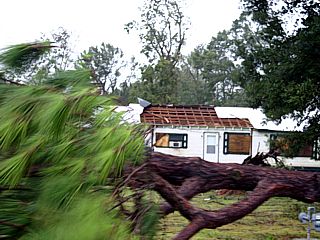
Here is another picture of a mobile home damaged beyond repair, with no roof, and a large tree felled in the foreground. Many trees and power poles were felled by hurricane Gustav in the Houma / Morgan City area, making some roads impassable. |
|
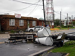
This is a picture of one of many downed power poles and transformers near morgan City, Louisiana as the storm was winding down. Downed powerlines were a continuous driving hazard during and after hurricane Gustav. |
|
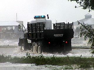
This picture was taken near Gufport, Mississippi after the storm (but still with 40-50 MPH on-shore winds), with Highway 90 under water and a police emergency vehicle making its way east through the storm surge, which was a s high as 14 feet during the height of the storm. Fortunately, New Orleans saw less of an effect from hurricane Gustav than hurricane Katrina, 3 years prior. We were not able to spend much time after the storm in these area due to a curfew. |
|
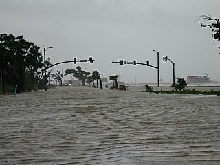
Here is another picture, looking east toward Gulfport along Highway 90, and the severe flooding of the storm surge caused by hurricane Gustav. |
|
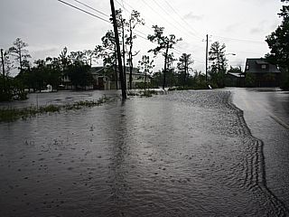
The storm surge from the Gulf of Mexico was able to penetrate quite a distance inland near Gulfport and St Louis Bay, causing extensive flooding. |
|
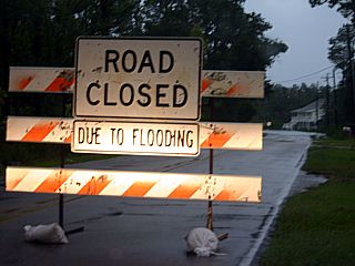
Here is a picture of a road (leading out of the western sections of Gulfport to Interstate 10) that was rendered impassible from storm surge flooding. The flood can be seen father up the road, beyond the road closure signs. About 2 million people needed to be evacuated from New Orleans and adjacent areas because of the fear of the deadly flooding associated with hurricanes. |
HTML File "gustav08.htm" - Developed By Chris Collura
To Return To The HOME Page Of This Site Click The "INDEX.HTM" Link Here!