
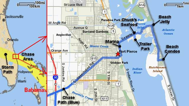
| This area shows pictures taken from the observations of strong category-two hurricane Frances in East-Central Florida in Saint Lucie County. The storm, originally a tropical disturbance that moved off Africa, formed in the tropical Atlantic, crossed the Bahamas, then moved extremely slowly into the East-Central Florida coast. At one point, the storm was a strong and very large category-four hurricane with 145-MPH winds, but weakened to 105-MPH as it made landfall on Saturday and Sunday, September 4-5, 2004. The central pressure at time of eye interception was measured at about 960 MB with a very large eye nearly 70 miles across. This hurricane interception included a long wait through gradually increasing winds which climaxed at over 110-MPH with higher gusts. The storm was moving WNW at less than 5-MPH so a long period of wind, rain, and storm surge was observed with the storm (surge being the main goal for documentation). The entire chase was from September 3 through September 5, with about 285 total miles logged. Note - This page may take a while to load on some SLOWER connections! |
| CHASER NAME | HOME CITY | CALLSIGN | OCCUPATION |
| CHRIS COLLURA | MIRAMAR, FL | KG4PJN | COMPUTER ANALYST |
| DOUG KIESLING | MINNEAPOLIS, MN | N/A | BNVN PRESIDENT |
| JASON FOSTER | BALTIMORE, MD | N3PRZ | ARCHITECT |
| JEFF GAMMONS | WPB, FL | KG4PGA | PHOTOGRAPHER |
The participants below are not from the former "Weathervine", SKY-CHASER, or BNVN chase team(s) but did actively participate in our storm research efforts and deserve appreciation for their great help and severe weather expertise.
In addition to our immediate chase teams and other accomplices, a film crew from Germany also accompanied us during part of the chase.
| CHASER NAME | HOME CITY | CALLSIGN | OCCUPATION |
| JIM EDDS | FLORIDA KEYS | KG4TBE | PHOTOGRAPHER |
| MARK RACKLEY | FLORIDA KEYS | N/A | DIVE INSTRUCTER |
| SCOTT BLAIR | LITTLE ROCK, AR | KD5KOW | STUDENT |

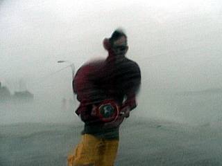
The graphic above is simply a before, during, and after documentation pictures of what 105-MPH winds can do to a poncho-type vinyl raincoat. The first picture is the blue poncho intact, with the "Shamu" logo on it from Seaworld in Orlando, FL. The second picture is myself wearing this same poncho in strong category-two hurricane forced winds as Frances was making landfall in Fort Pierce Inlet. The second photo was taken by Jeff Gammons as a German film crew also was filming me standing nearly sideways. I can remember the coat flapping so violently and pieces flying off of it! The third picture is what is left of the tatttered poncho. We even opened an umbrella in the winds and it simply exploded.
|
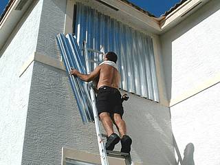
Hurricane Frances was a storm which threatened most of the Florida east coast. Before intercepting the hurricane, preparations first needed to be done to my home, including the daunting task of shuttering up sixteen windows. |
|
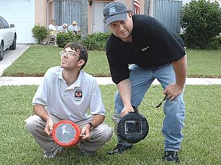
Here is a picture of Jason Foster (N3PRZ) holding another version of the "surgecam" water housing to the left as Doug Kiesling with BNVN shows his plastic enclosure for his larger Sony VX 2100 camcorder. |
|
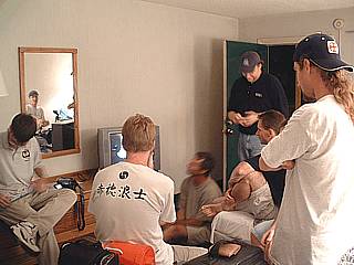
There was our immediate chase group, Jeff Gammons (KG4PGA), Myself, Jason Foster (N3PRZ), Jim Edds (KG4TBE), and Doug Kiesling, plus several others including a German documentary firm, Scott Mcfarland, Scott Blair, and Dave Lewison to name a few. After just being on channel 12 news, our group watches the news and hurricane information in the motel room. |
|
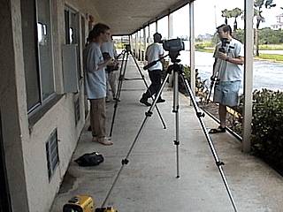
Some members of the large chase group filmed the storm from the motel off highway 70 near Interstate 95. Here some chasers set up there equipment for the first rain bands ahead of hurricane Frances. |
|
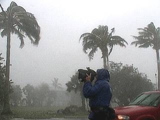
A member from the German documentary group films some whipping palm trees during the first portions of hurricane Frances at Fort Pierce Beach. |
|
During the first half of Frances, stiff northerly winds of hurricane force blow the palms along Fort Pierce Beach. |

|
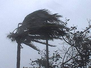
Palm trees continue to blow strong with winds gusting near 90-MPH at out motel along highway 70 during the SECOND HALF of hurricane Frances. This was the second full day of hurricane conditions. Note the palms are showing a southerly wind, as the view is to the east. |
|
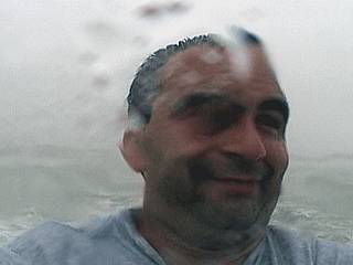
Taken with the "surgecam" weatherproof video camera case, a self portrait of myself in 100-MPH winds on Fort Pierce Beach clearly shows its effects on my face. At times, it felt as if your skin would be ripped by the rain, wind, and spray. My raincoat was literally ripped off me and torn to pieces by these winds! |
|
Here is Jason Foster running past me at the south side of Fort Pierce Inlet as he holds another "surgecam" video camera case I built for him and Doug. Winds here are about 75-MPH gusting to near 100. |
|
This is another picture of Jason Foster taking wind measurements while parked at Fort Pierce Inlet Park on the south side of Fort Pierce Inlet. He measured a wind here of about 80-MPH. |
|
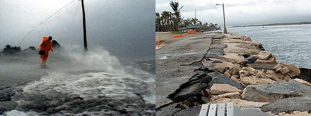
Wind gusts to near 100-MPH blast the south side of Fort Pierce Inlet during the onset of hurricane Frances. Doug Kiesling is the one in the orange raincoat. One member of the German documentary group is in the background. Note the storm surge and power lines to the jetty lights coming down. |
|
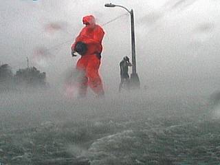
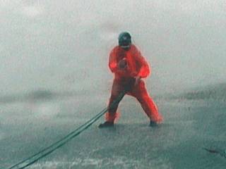
Doug Kiesling testing his "rope trick" in 100-MPH wind gusts. He made a "harness" out of some climbing rope and quick-release connectors and tied one end to an anchored bench on the Fort Pierce south jetty as Jim Edds (out of frame to the left) and myself filmed. The purpose of this safety rope to to allow exposure to winds that would bowl a man over otherwise. |
|
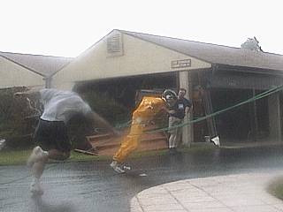
Here is another picture of Doug's "rope trick" being put to the test near some beachfront condominiums on the Fort Pierce oceanfront. Winds here are sustained over 90-MPH with gusts well over 100-MPH. Jason Foster is in the yellow raincoat and crash helmet harnessed up to the ropes. Note the angle he is leaning at. I am in the foreground, getting knocked down and Doug Kiesling is against the far wall (both of us, except for Jason, were out of the "wind-tunnel core"). |
|
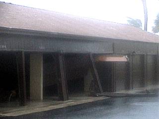
Damage to private garages near beachfront condominiums on the Fort Pierce oceanfront. One garage door is actually coming apart in this video frame image, with winds over 100-MPH. |
|
Not your ordinary day at the beach, trust me. The winds here are sustained at 90 to 100-MPH as the "bar" (outer portion of the main storm eyewall) reaches our location. Note the wind-whipped sand streaming from left to right. If you put your hand into this stream of sand for a few seconds, it came out with small cuts on it. We are taking pictures in the "burble", which actually allowed a small puddle to even form (lower right), caused by the beachfront stairs, which prevented us from being sand-blasted alive. |
|
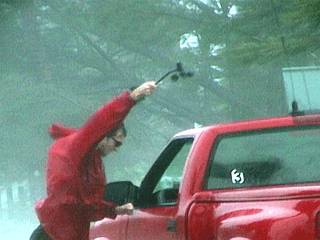
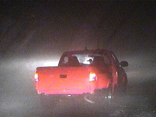
Jason Foster (N3PRZ) loses a belt in his pickup truck and is stranded. Ofcourse, he was not alone, and we picked him up. Winds here are sustained near 105-MPH with higher gusts. ALWAYS use the "buddy system" when chasing a hurricane! |
|
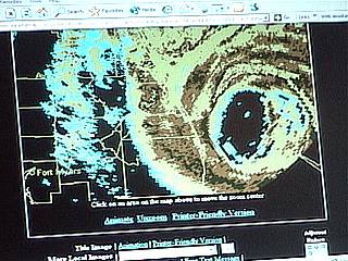
An ominous picture of the storm radar appears on Doug Kiesling's mobile internet connected laptop (special thanks to Sprint and its exceptional performance in this situation). Note the large black elliptical area just southeast of our position, that is the large eye of the storm. As the eye passed south of us, winds dropped to about 50-MPH, and we left the barrier island for the mainland for safety. We later went south into the eye to measure a central pressure of 960 MB, in calm winds, and even saw some moonlight peeking through the clouds! |
|
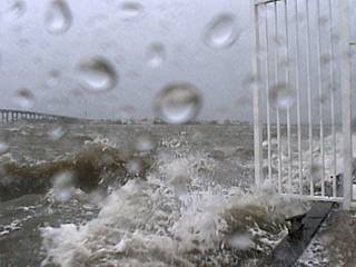
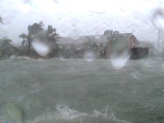
In the main eyewall of hurricane Frances, sustained winds of 105-MPH were felt after dark. This picture was taken out the driver side of my chase vehicle (note the mirror in the lower right part of the image) while sitting near the eastern side of the Fort Pierce Beach causeway. The water on the ground is a few inches deep, and coming from a nearby marina, flowing UPHILL driven by at least 105-MPH winds. Maximum surge was about 8 feet above normal. Soon after this picture, winds gegan easing a bit as the northern part of the eye brushed by, that's when we all left the barrier islands. |
|
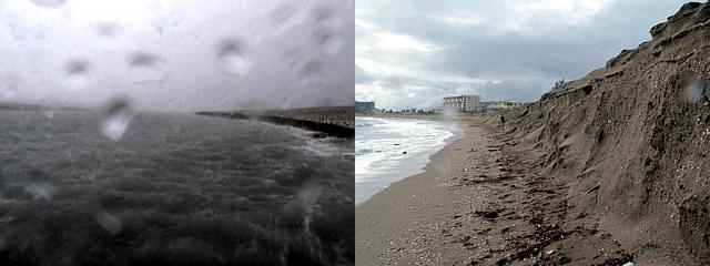
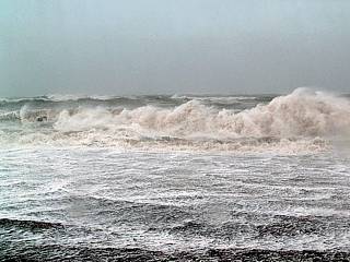
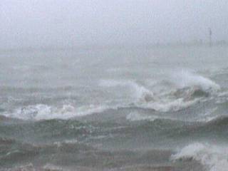
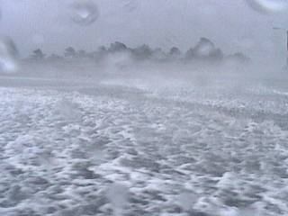
A violent hurricane surf pounds Fort Pierce beach just south of the inlet as hurricane Frances moves closer. Conditions here were winds over 60-MPH, gusting to about 80, with sand blowing so hard it literally was able to cut skin. The waves, breaking miles out, were over 25 feet. |
|
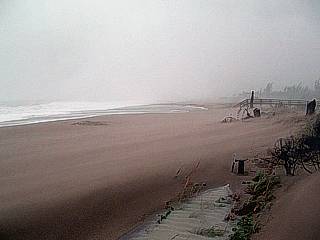
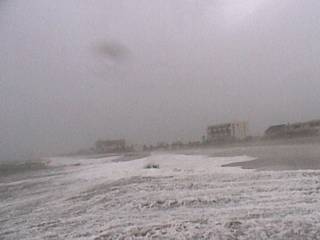
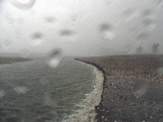
Here is another view down the beach in Fort Pierce towards the south as run-up (beach-ward flow of whitewater from breaking waves) covers most of the beach. Note how severely the beach is being eroded, and this is only the initial part of the storm! |
|
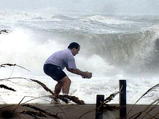
This is an "action shot" of myself standing near the surfline in front of the pounding hurricane surf filming the runup onto Fort Pierce beach. Jeff Gammons took this picture. |
|
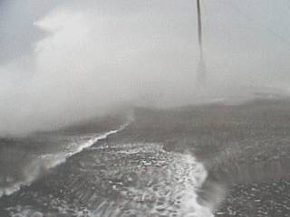
The tides are now running about 5 feet above normal, and winds are sustained near 70-MPH. The beach is completely under water, with run-up reaching the dunes. |
|
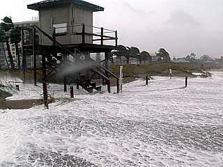
This picture shows the storm surge and run-up under the lifeguard stand at Fort Pierce Beach. |
|
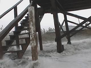
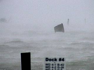
Here a large channel has been eroded into Fort Pierce beach just south of the inlet and jetty. this was strange because the beach was underwater farther south and water seemed to flow northward creating a river of water pouring back over the jetty and into the inlet. Winds here are 75-MPH with gusts near 100. The "surgecam" allowed this type of photography and video without damage to equipment. |
|
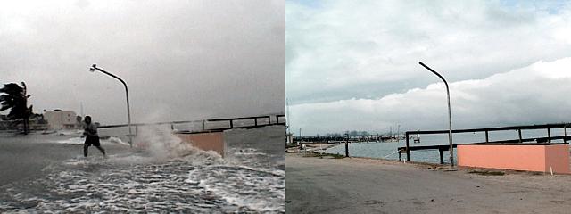
Waves batter the docks at the Fort Pierce Marina during the start of hurricane Frances. The waterproof "surgecam" case worked well to get this picture. |
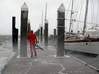
|
Before the marina was destroyed, we ventured out on the floating docks to get some active footage of the storm. Doug Kiesling is in the orange raincoat. |
|
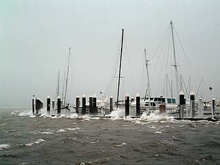
Fort Pierce Marina during the first part of hurricane forced winds as hurricane Frances began pusing ashore in Fort pierce. |
|
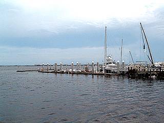
Taken from the same place as the above picture, a couple of days later when winds and seas returned to normal, the Fort Pierce marina reveals major damage with docks, pilings damaged, and boats sunk or destroyed. |
|
A chunk of roofing material becomes airborne then gets blown out into the bay (Indian River) south of the Fort Pierce Beach causeway. The roof debris actually skipped and flew over the water until it was out of sight. |
|
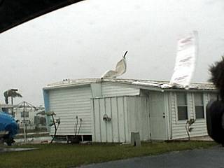
A large portion of a roof gets ripped off a mobile home in a trailer park off the Fort Pierce Beach causeway as winds gust over 80-MPH in hurricane Frances. |
|
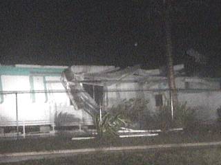
Here is another picture, taken at night, of another mobile home losing its roof to 100-MPH wind gusts. This storm lasted nearly 48 hours from start to finish, so once hurricane conditions set in, they continued for nearly two days! |
|
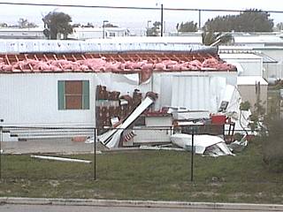
Here is a picture of a mobile home with its roof completely ripped off. This picture was taken from the end of the bridge of the Fort Pierce Beach causeway. |
|
With winds over 80-MPH, the bay (Indian River) is whipped into a frenzy by the strong winds with battering waves. |
|
Here is a video picture (frame-grab) of Fort Pierce Beach underwater while being whipped by winds near 100-MPH. The view is to the west. |
|
Taken from the same place as the above picture, here is the view to the east on Fort Pierce Beach as winds gust to near 100-MPH. Note the spray and foam in the air. All these "action" storm surge shots have been made possible by the "surgecam" video camera housing! |
|
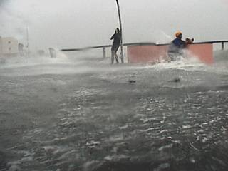
Storm surge covers a bayfront business and US Coast Guard station as hurricane forced wind prevailed. Jim Edds is taking video to the right, in a modified underwater camera housing. My video camera is in my casing, the 'surgecam", and was used to take this shot. Water hear is at least 5 feet above normal, and you could actually see fish swimming besides our feet! |
|
Here is another picture of the storm surge flooding taken from out on a dock looking back towards the US Coast Guard station. |
|
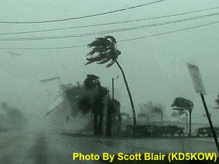
Here is a video frame-grab of the roof of Chuck's Seafood Restaurant being ripped off and flying through the air during an intense feeder band. The roof is flying from right to left. This picture was taken by storm chaser Scott Blair (KD5KOW) and used with permission. |
|
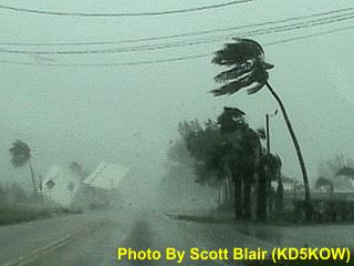
This is another picture of the roof of Chuck's Seafood Restaurant landing on the left side of the road (Fort Pierce Causeway). The picture was taken by storm chaser Scott Blair (KD5KOW) and used with permission. |
|
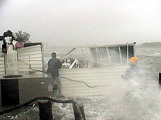
Chucks Seafood Restaurant along the Fort Pierce beach causeway takes a battering from the hurricane-forced winds and storm surge as Jeff gammons, left and Jim Edds, barely visible in the spray to the right, watches. The roof was ripped off this part of the restaurant and deposited over 150 feet downwind across the street. This part of the restaurant was there since 1971. |
|
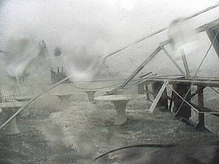
This is another picture of the 1971 addition to Chuck's Seafood Restaurant being flooded and ripped apart. Once again, the "surgecam" camcorder housing allowed these grim images to be taken as Frances continued to lash Fort Pierce with winds over 105-MPH. |
|
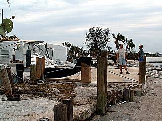
Here is Chuck's Seafood Restaurant after the storm on the Fort Pierce causeway. Note that the waterfront addition to the restaurant has been completely scoured off its slab by the winds and storm surge. |
|
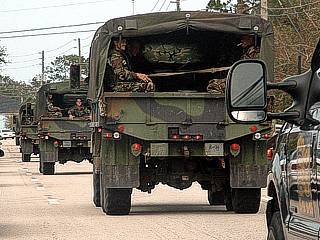
The US Army National Guard convoys into the hardest hit areas in Fort Pierce along highway 70 to bring supplies, maintain order, and provide disaster relief to those affected. |
|
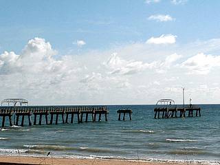
Exceptionally large swells and storm waves battered Florida for a long period of time as hurricane Frances passed over. In this picture, taken a few days after the storm, shows the Lake Worth municiple fishing pier that was seriously damaged by waves in excess of 15 feet during the storm. |
HTML File "franc04.htm" - Developed By Chris Collura
To Return To The HOME Page Of This Site Click The "INDEX.HTM" Link Here!