
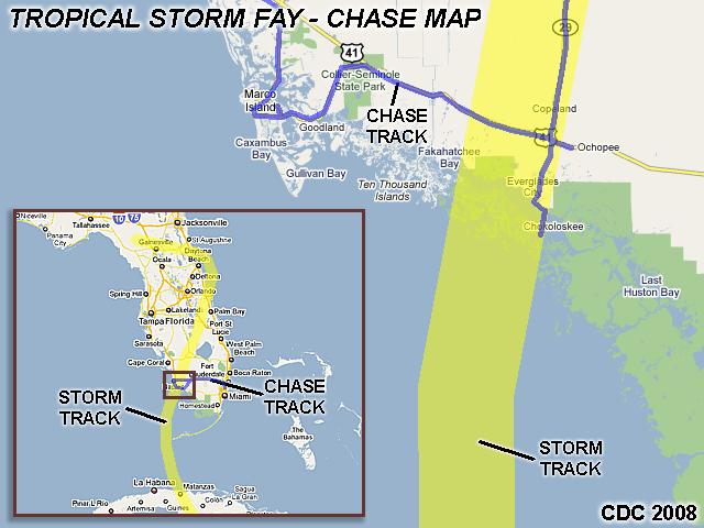
| This area shows pictures taken from the observations of strong tropical storm Fay in southwestern Florida panhandle in Collier County. The storm, was a tropical cyclone that originated from a disturbance that came off Africa and crossed the tropical Atlantic and formed into a tropical depression, then a tropical storm near Hispanola. The storm crossed the Dominican Republic, headed west, then turned northwest across Cuba and into the Florida Straits on August 18, 2008. The storm fluctuated in intensity as it was interacting so many times with land. The storm passed near Key West, Florida late in the day on August 18, strengthened to a strong tropical storm, then made landfall near Everglades City during the early morning of August 19. The storm had sustained winds of 60-65 MPH and a central pressure of 986 MB at landfall and over west-central Florida. The storm was intercepted from Marco Island to south of Everglades City, where 60-MPH winds and a storm surge of 5-feet, or more, was observed. The calm "eye" of the storm was also experienced, where a pressure measurment of 987 MB was taken. Fay had torrential rains and thunderstorms in its core. Some tree damage, power outages, and severe flooding (from both rainfall and storm surge) was noted. Total mileage logged was 322 miles. Tropical storm Fay intensified a bit later on the 19th AFTER making landfall OVER land (Florida). This area will be updated once this event is through. Note - This page may take a while to load on some SLOWER connections! |
| CHASER NAME | HOME CITY | CALLSIGN | OCCUPATION |
| CHRIS COLLURA | MIRAMAR, FL | KG4PJN | COMPUTER ANALYST |
|
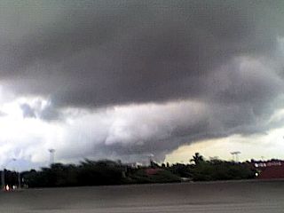
Here is a picture of a TCMS (Tropical Cyclone Mini-Supercell) along and ahead one of the feeder bands of tropcial storm Fay on August 18, 2008. These are thunderstorm cells with shallow mesocyclones and have the potential of producing tornadoes in the forward-right quadrant (right side) of a tropical cyclone. The view here is to the west, and the tornado-warned (radar indicated) cell is moving to the right (north). The unmistakable clear-slot of a rear-flank downdraft can be seen (center) with a lowering / wall cloud behind it (lower-center). Low-level shear in this region of a tropical system allows rotating storms to develop if there is enough instability (usually in the feeder / spiral bands). |

|
Here is a picture of myself resting in my chase vehicle (and trying to get some rest) before the arrival of tropical storm Fay in Marco Island, Florida. Just included this picture to show you how a hurricane / tropical chase is. There is usually either no time / no open place to stay at a hotel, and sleeping in the car / taking short naps is all you can do if you get tired. This is why many of those who chase tornadoes will not chase a hurricane because of the "roughing it" and discomfort factor. |
|
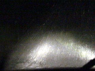
Torrential rains associated with the core of tropical storm Fay, driven by wind gusts of near 65-MPH, herald the arrival of the storm near Marco Island. The rains here are in the inner convection around the storm center and this thunderstorm convection is called the "hot towers" (convective chimney) of the tropical cyclone. |
|
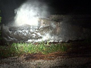
Waves batter a sea wall / dock at the southern tip of Chokowloskee as winds increase to about 60-MPH from the east and southeast. Chokowloskee is a small island and fishing town just south of Everglades City in SW Florida in the "Ten Thousand Islands" mangrove region. |
|
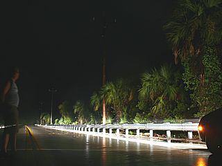
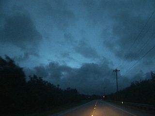
A period of calm is experienced in the circulation center of tropical storm Fay on Highway 41 between Everglades City and Marco Island. In this picture, the trees are still and an eerie fog hangs in the air. Pressure is at its lowest here, and was measured at 987 MB. The strong winds are all around this calm "eye" of the storm. The calm area was roughly 5 miles wide (small). |
|
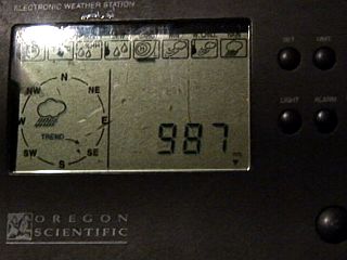
Here is a picture of my Oregon Scientific console showing the barometeric pressure in the center of tropical storm Fay. Here it shows 987 MB in the storm center at about 5:45 AM, which was after the 5 AM advisory from the National Hurricane Center relayed 989 MB from an aircraft. The storm was starting to strengthen over land, obviously, and would later drop one more MB to 986 MB over the warm swamps. |
|
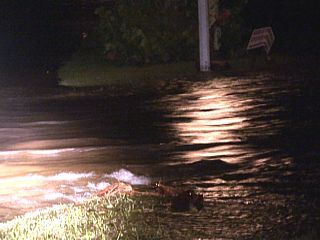
The storm center has now made landfall, and any position to the east of its calm center yielded 60-65 MPH winds, which were now changed to an on-shore flow, which is from the southwest. Back in Everglades City, a torrent of Gulf water, backing up from the Chokowloskee bay, spills into the town and covers the roadways. This road (Copeland Avenue) was high and dry at 5:45 AM, at 6:00 AM it looked like this! About 3-4 feet of water, or more, flooded Everglades City within mere minutes once the storm core was onshore. |
|
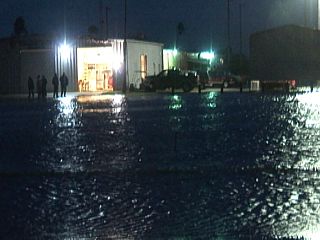
Here is another picture of flooding in Everglades City near Datura and Copeland. The water is rising fast and is inundating houses and businesses. Fortunately, many homes in this area are built high on stilts / pilings just for this reason (major flood risk). |
|
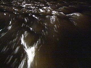
Here is another view of how fast the knee to waist-deep water was flowing past me as the storm surge was racing into Everglades City. I am standing on the median of Copeland Avenue in waist-deep water. This was just before I retreated and left the Island. I heard this was a "10-minute" surge, where it later rushed out shortly after. |
|
This picture is a long exposure of the sky near the intersection of I-75 and highway 29 near Immokolee and east of Naples, Florida. This is just south of the edge of the calm center of tropical storm Fay. The clouds thin a bit, and pre-dawn twilight / moonlight can be seen through the center (or "eye" like feature) of tropical storm Fay. Fay actually continued to strengthen while OVER land, which is unusual, developing an eye and increasing in intensity due to the warm swamp / flat land and favorable upper air conditions. |
|
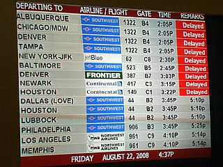
With tropical storm Fay over Florida, and a wide swath of weather, thunderstorms, wind, and rain surrounding the storm, many flights at Fort Lauderdale airport were severely delayed (for more than 1 hour). Frustrated air travelers had to deal with arriving at the airport and seeing the "red" messages on their flights, or, if it was not "red", it left at least an hour or two later than the flight was supposed to. |
|
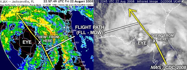
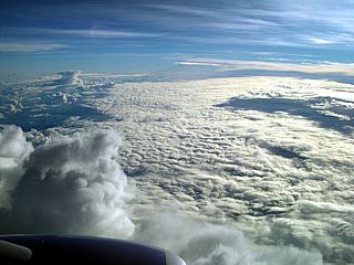
This picture was taken from flight 2129 (FLL to MDW) while over northern Florida (in the position denoted in the diagram at the top of this section above) and at an altitude of 38,000 feet. The un-mistakable circulation center of tropical storm Fay becomes apparent as we break out of heavy cirrus clouds and light turbulence and are greeted with this clear and perfectly smooth air. The center of the storm is cloud filled in the lower levels (because it's over land), and is marked by the "swirl" in the lower clouds to the middle-right side of this picture. Deep (thunderstorm) convection surrounds this clear "eye" with a large convective cell just to the lower-left in the picture. The view is to the southwest, and there is a "break" in the convection around the storm, which also matches perfectly to the "break" in the annotated radar diagram above. |
|
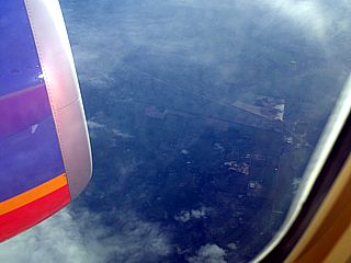
Looking nearly straight down there is actually a break in the lower clouds, offering a view of the ground. One on the ground would experience near calm winds with blue sky (and possibly a 737-400 jet plane - US) peeking through! |
|
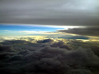
The large clearing of the center of Fay is crossed in about 10-15 minutes. The stronger convection is on the northern (forward-right) side of the westward-moving storm. A thunderstorm anvil from the "hot towers" associated with Fay is much higher that we are. This a part of the weakening central-dense-overcast (CDO) of the storm, and a portion of this often obscures part of the eye. We are at 38,000 feet, and the CDO / primary cirrus shield is as high as 60,000 feet. The view is to the SSW, and we are already past the calm "eye" and over the convection already. Turbulence is starting, and will last another 20 minutes. |
|
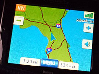
Here is a picture of a hand-held GPS showing our location relative to northern Florida, headed to the NW at 534 MPH. This is about the time we were "leaving" the "eye" of tropical storm Fay. |
HTML File "fay08.htm" - Developed By Chris Collura
To Return To The HOME Page Of This Site Click The "INDEX.HTM" Link Here!