This area shows pictures taken from the interception and penetration of hurricane Andrew in southern Dade county in Florida on August 24, 1992. This storm formed in the Atlantic and moved through the Bahamas before smashing ashore south of Miami during the wee hours of the morning. Lack of light limited photography of the storm eyewall. The storm produced winds sustained at 165-MPH with gusts near 200-MPH. Highest winds in the chase area were gusts to 168 MPH. Andrew, originally a category 4 storm and upgraded 10 years later by the National Hurricane Center in late 2002 to a category 5, caused at least 25 BILLION dollars in damages, the costliest natural disaster in United States history (until hurricane Katrina struck the Gulf coast in 2005)!


PICTURES OF HURRICANE ANDREW CHASE

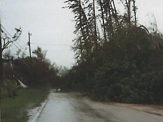
Trees block a roadway in South Kendall, Florida on the morning of August 24, 1992. The chase required a hunker down in a shelter when the worst part of the storm came by. The picture above was while trying to drive out of the disaster area. The hurricane is still in progress with winds over 75 MPH and torrential rains while this picture was taken.
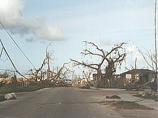
A street in Homestead, Florida on August 25, 1992. This was one day after Hurricane Andrew passed through this area with 165 MPH sustained winds. Damage is extensive, comparable to that of a strong tornado 20 miles wide!
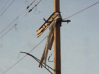
In Homestead, Florida on August 25, 1992, debris lies hung in the powerlines and utility poles along Highway US 1. During the hurricane eyewall one day earlier, the air literally became filled with flying debris at aircraft speeds. These "missles" are capeable of destroying everything in their path.
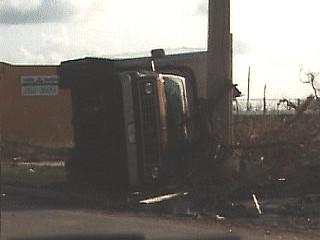
A utility truck comes to rest on its side along Highway US 1 in Homestead, Florida on August 25, 1992. The truck tumbled across the highway during the 165 MPH winds in the storm and slammed into the concrete utility pole.
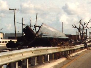
A mangled tractor trailer lies on the median of Highway US 1 in Homestead, Florida on August 25, 1992. The truck was literally launched by at least 165-MPH winds and carried for some distance before coming to rest on the median barrier.
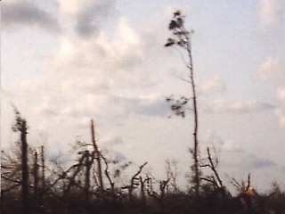
After hurricane Andrew a forest lies nearly completely leveled in Homestead, Florida on August 25, 1992. The forest was along Highway US 1 in a heavily wooded area. Nearly every tree was knocked down by the category-5 forced hurricane winds. In some places, you could actually see the horizon through the downed trees!
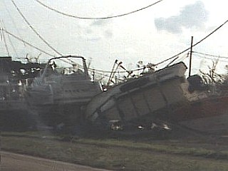
Along Highway US 1 in Homestead, Florida on August 25, 1992. Boats lie wrecked on the west side of the street, probably pushed from a marina by the 18 foot storm surge.


INTERESTING FACTS ABOUT HURRICANE ANDREW

  • Hurricane Andrew was what hurricane specialists call a "Super Hurricane". This is a hurricane with outrageously extreme sustained wind speeds. In hurricane Andrew, sustained winds were officially rated at category 5 strength on the Saffir Simpson scale of 1 to 5, with winds near 165 MPH!


  • This hurricane was ever so close to not even becoming a hurricane and / or staying out at sea. Just days before tearing across the Bahamas and Florida, Andrew was weakening (only 40 MPH tropical storm) in response to an upper trough while north of Puerto Rico. Had this trough been only slightly stronger, Andrew would have dissipated or curved out to sea. Instead, the trough weakened, and Andrew resumed moving to the west and intensified explosively.


  • Until hurricane Katrina in 2005, hurricane Andrew was the costliest natural disaster in recorded US history. Estimates still show that losses were over 25 Billion US Dollars. Aside from nearly 30 deaths, Andrew caused many "secondary" effects such as failed businesses (especially insurance), federal expenses (military personnel, disaster relief), increased costs of living, even social problems among victims of the storm such as looting and fraudulent business practices.


  • This hurricane actually made three landfalls, ofcourse the most obvious one is in southern Miami-Dade county in Florida. Before Florida, Andrew made a temporary landfall across a small island in the Bahamas. After Florida, it re-emerged over the Gulf of Mexico, intensified again, and struck Louisiana.


  • The winds around the eye of hurricane Andrew at its peak intensity were very similar to those in a strong tornado. Large tornadoes have smaller vortices called "suction vortices" rotating around the main circulation. The eye wall of hurricane Andrew also had sub-vortices, called "mini swirls". Dr Fujita dicovered both sub vortex types with large tornadoes in the US Great Plains and studying damage patterns after Andrew. These sub vortices are why some houses had minor damage next to ones totally demolished during Andrew.


  • Like tornado wind estimates and damage patterns, hurricane Andrew's peak winds were not physically measured. All possible wind speed indicators broke BEFORE Andrew's peak winds arrived, so a lengthy period of damage analysis was done. Evidence showed that wind speeds in Andrew's core were sustained around 165 MPH, with gusts well over 200-MPH, over a football field a second!


  • Hurricane Andrew actually had what hurricane experts call a "double eye wall". This is literally one eye about 8 miles wide inside a larger one about 25 miles wide. The strongest winds are in the inner eye wall that surrounds the calm center of the storm. The outer eyewall has weaker winds than the inner wall but stronger winds than those found in the space between the outer and inner walls.


  • Just prior to landfall in Florida, Andrew crossed the 90 degree waters of the Gulf Stream current east of Florida. At the same time, the high-altitude cloud tops of Andrew's core cooled during the night, causing the updrafts within to increase. The storm undergone "explosive deepening" with central pressure falls in the 3-mb per hour range! This is probably what lead to the original "under estimation" of Andrew as a category-4 hurricane.


  • Wind pressures in such a storm cause damage from "aerodynamic drag" on structures. At 120-MPH, drag force is about 60 pounds per square foot. At 240-MPH, it is four times, or 240 pounds. With peak gusts in Andrew over 200-MPH, drag forces of at least 200 pounds per square foot were possible. That means that a 4x8 foot door in such winds creates a drag force of 6,400 pounds (over 3 tons)! Imagine the 100 foot wide by 20 feet high side of a building?


  • Hurricane Andrew was rated a category-5, which means it had sustained winds near 165-MPH. In tornadoes, there is also a scale called the Fujita scale. Tornadoes, however, are measured by peak gusts, not sustained winds. Peak gusts in Andrew exceeded 200-MPH, in a tornado, such a gust would rate it a strong F3 (on a scale from 0 to 5) to maybe a borderline F4. Such tornadoes are the mile-wide "monsters" we rarely see in the Great Plains. Imagine such a tornado 20 miles wide? That's basically the damage seen in Andrew's 20 mile wide eye wall.


  • Unfortunaetly, Andrew was a storm that brought out the worst in some ill-hearted people. One example was a charge of $15 dollars for a bag of ice in the "disaster area" of Andrew. Another was an individual who claimed $6,000 for damaged to her home and used it for cosmetic surgery instead. The insurance paid for the damage, claimed as damage from Andrew, was in fact, not caused by the storm. There also were many instances of people running into damaged stores and stealing merchandise (looting) before the US Army stepped in to restore order.


  • HTML File "andrew92.htm" - Developed By Chris Collura

    To Return To The HOME Page Of This Site Click The "INDEX.HTM" Link Here!