
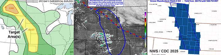
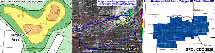
| This section is for storm chases done in the central / Midwestern United States during the year of 2025. This includes all storm chasing activities (including any major chase "expeditions") during the year of 2025 in the central USA (aka "Tornado Alley"). For 2025, all chases in the central USA will be logged in this section, with many of the chases being possible "spot" chases / major severe weather "setups" chased. Here you should find many pictures of lightning, tornadoes, hail, strong winds, along with many severe thunderstorm elements. Keep in mind that this chase log is scientific evidence and portrays my on-going storm chasing research. It has been placed on this page for easy reference and meteorological interests. Please do not plagiarize or copy this document to other sites for distribution. Note - This page may take a while to load on some SLOWER connections! |
STORM CHASING - CENTRAL UNITED STATES - 2025 CHASE LOG
| CHASER NAME | HOME / BASE CITY | CALLSIGN | CHASE DATES | OCCUPATION |
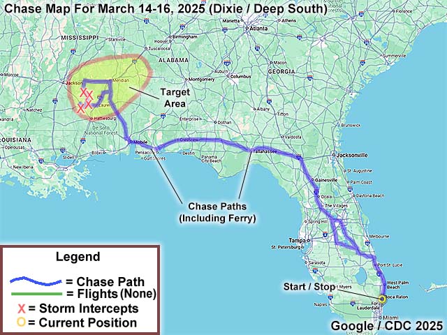
| CHRIS COLLURA | DEERFIELD BEACH, FL | KG4PJN | 3-14 TO 3-16 | IT CONSULTANT |
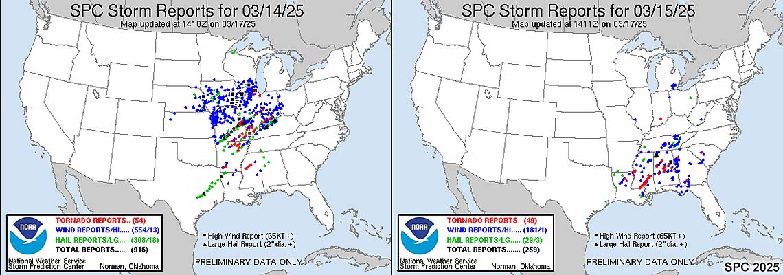
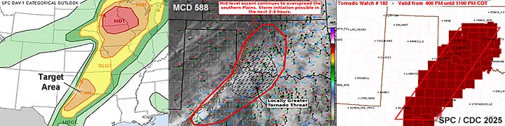
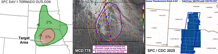
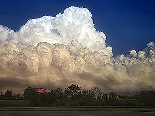
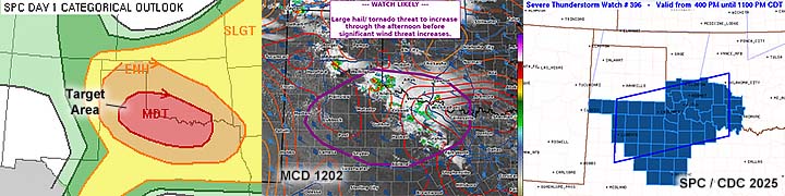
1. March 15, 2:00 PM - Interception and observation of a severe and tornadic thunderstorm near Raleigh, Mississippi in Smith County, and near SR 18 and SR 35. The storm was a small HP supercell on the northeastern side of a cluster of severe and tornadic storms. The storm core was not directly penetrated, and a large wall cloud / strong rotation was noted on the SW side of the storm as it passed Raleigh. Rapidly rotating scud and a possible weak and brief tornado was noted with the passage of this storm before it moved northeast and weakened. Heavy rain, 40 MPH winds, and occasional lightning was also noted with this storm. Conditions causing the storms were modest surface heating, a strong low pressure trough / confluence, and a powerful upper trough. Documentation was digital stills and HD video. A 2022 Jeep Renegade was used in this chase. A PDS (particularly dangerous situation) tornado watch was in effect for the area until 6 PM CDT.
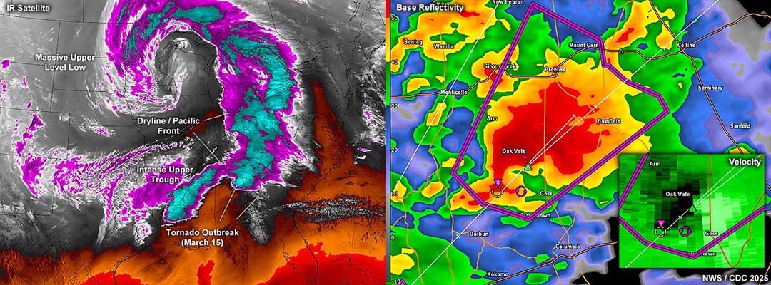
2. March 15, 3:00 PM - Interception and observation of an extremely severe and tornadic thunderstorm from Covington to Smith counties from near Collins and northeastwards towards Taylorsville, Mississippi via Highway 84 and SR 37 through Hot Coffee (yes, there is a tiny Mississippi town with that name)! The storm was a powerful HP storm, which is the same storm that caused a tornado to devastate Tylertown and later cause damage in Taylorsville. The storm was first observed near Collins, with a brief view of a wedge tornado looking SW from near the Highway 84 and 49 intersection. The large, fast moving tornado was highly rain-wrapped. And was noted passing Highway 49. Heading back east on Highway 84, a view of a wedge tornado was visible at times, with an intense RFD clear slot, and striated storm updraft with a very low cloud base. The tornado was encountered again, albeit low contrast, south of (and before it hit) Taylorsville looking north on SR 37, which was blocked from downed trees. The storm core was not penetrated. Heavy rain, 60 MPH winds, and frequent lightning was also noted with this storm. Conditions causing the storms were modest surface heating, a strong low pressure trough / confluence, and a powerful upper trough. Documentation was digital stills and HD / 4k video. A 2022 Jeep Renegade was used in this chase. A PDS (particularly dangerous situation) tornado watch was in effect for the area until 6 PM CDT.
3. March 15, 3:30 PM - Interception and observation of another very severe and tornadic thunderstorm east of Collins, Mississippi in Covington County along Highway 84 and near SR 37. The storm was a powerful HP storm. A possible rain-wrapped tornado was observed with this storm, before it weakened as it headed towards Smith County. The storm core was not penetrated. Heavy rain, 50 MPH winds, and frequent lightning was also noted with this storm. Conditions causing the storms were modest surface heating, a strong low pressure trough / confluence, and a powerful upper trough. Documentation was digital stills and HD / 4k video. A 2022 Jeep Renegade was used in this chase. A PDS (particularly dangerous situation) tornado watch was in effect for the area until 6 PM CDT.
4. March 15, 4:00 PM - Interception, indirect penetration, and observation of a very severe and tornadic thunderstorm from Calhoun to Clarke County, Mississippi, from near Calhoun along Highway 84, and towards Pachuta near I-59 and SR 18. A large tornado was first observed when this storm was encountered, once again rapidly rain-wrapping as the storm was a powerful and dangerous HP supercell. The tornado continued northeast and the area to its SE near Pachuta was encountered along I-59 in torrential rains. The storm core was not directly penetrated. Heavy rain, winds over 60 MPH, and frequent lightning were encountered with this storm. Conditions causing the storms were modest surface heating, a strong low pressure trough / confluence, and a powerful upper trough. Documentation was digital stills and HD / 4k video. A 2022 Jeep Renegade was used in this chase. A PDS (particularly dangerous situation) tornado watch was in effect for the area until 6 PM CDT.
This concludes the chase log for the SE and Deep South USA (including chases in Mississippi) chase trip for March 14-16, 2025. The summary includes a total of 4 observations, out of which there were 4 severe thunderstorms. A total of 4 tornadoes were observed from these severe storms, at least one of them significant. The main chase vehicle conducting this chase a 2022 Jeep Renegade. This information was prepared exclusively for the National Weather service and the team of Skywarn storm spotters.
|
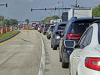
Crazy traffic during the afternoon of March 14, 2025. This was trying to get around the Orlando area, with the entire FL Turnpike closed due to multiple accidents. This is Highway 27 through Haines City. |

|
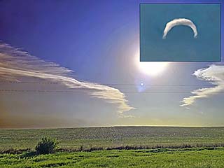
Sun-dog observed while heading northwest through northwestern Florida before sunset. The high clouds are the fringes of the massive upper level disturbance over the central USA. |
|
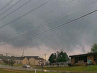
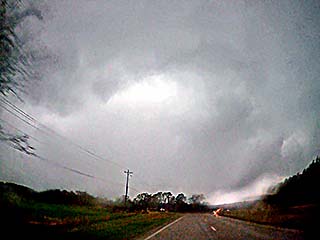
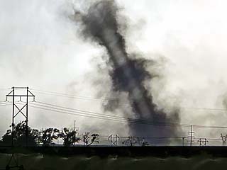
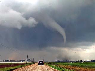
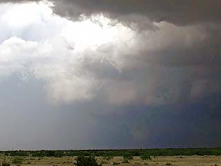
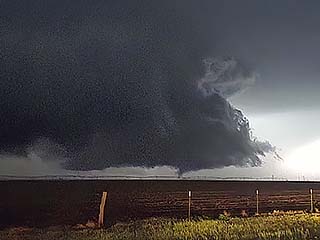
Weak / brief tornado (lower right) forms near Raleigh, Mississippi during the early afternoon of March 15. This was brief and caused little or no damage. The view is to the southeast. |
|
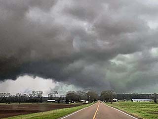
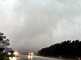
A powerful supercell, with large tornado (barely visible near the lower-center of the picture), approaches Collins, Mississippi around 3 PM. This is the same storm that caused major damage and fatalities in Tylertown. The view is to the southwest. |
|
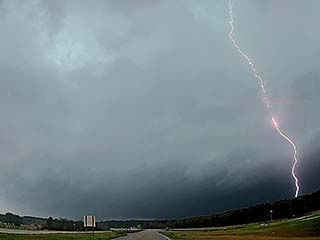
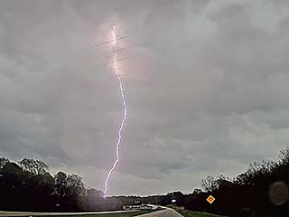
Frequent lightning with a large CG strike, with the large tornado (left edge over roadway near picture center) to the southwest near Collins. |
|
Limited view of wedge tornado partially hidden by the trees east of Collins, Mississippi and north of Highway 84. Note the powerful RFD to the left. The view is to the north. |
|
Another view of the large tornado between Collins and Taylorsville from the intersection of Highway 84 and SR 35. The view is to the northwest. |
|
Tornado, slightly right of center of picture, moves NNE into Smith County and will soon cause damage in Taylorsville. The view is to the NNW along SR 35 north of Hot Coffee. |
|
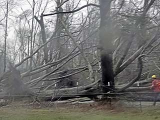
Downed trees in Smith County near SR 35. This tree damage also blocked the roadway. |
|
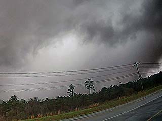
Another supercell with weakening tornado near Collins. This was another HP supercell that "trained" after the one that went from Tylertown to Taylorsville. The view is to the north and northwest. |
|
Large CG lightning strike east of Calhoun and west of Laurel, Mississippi near Highway 84. The view is to the ENE. |
|
Developing tornado with yet another intense HP supercell near Calhoun. The view is to the southwest, with the multi-vortex tornado developing to the far right. RFD and rain-wrap is to the left. |
|
Calhoun tornado rapidly becoming rain-wrapped. The view is to the west. |
|
Zoomed in shot of the Calhoun tornado, now very poorly contrasted with rapidly moving sheets of rain (from left to right). The view is to the west. |
|
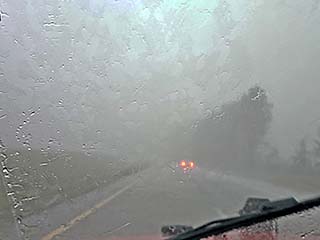
Penetrating extremely heavy rains and strong winds in Clarke County, Mississippi near Pachuta along I-59. There was still a tornado at this point, but it was rain-wrapped and I am in the wet RFD. |
|
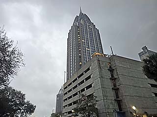
Passing downtown Mobile, Alabama late in the day, and near I-10. Beautiful new sky scrapers grace the Mobile skyline under a dreary steel-gray sky. |
|
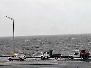
Minor coastal flooding off I-10 east of Mobile on the bay, due to strong southerly winds late in the day on March 15. |
|
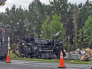
March 16 involved a trip back home from Tallahassee, Florida. Some storms over NW Florida caused major accidents and traffic delays, once again, along I-75 near Gainesville. Here an RV suffered a major wreck. |
|
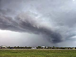
A marginally severe MCS looms west of Stuart, Florida north of the FL Turnpike. These storms were caused by the southern edge of a cold front / outflow that pushed off the eastern US coast. |
|
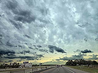
View leaving the mess of storms and clouds looking south while nearing Martin and Palm Beach County, Florida. High pressure aloft, usually south of Florida and over the Caribbean, often prevents extremely severe weather from the central USA from nearing south Florida - Instead moving north and east. |
| CHASER NAME | HOME / BASE CITY | CALLSIGN | CHASE DATES | OCCUPATION |
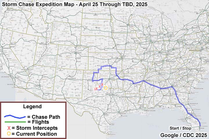
| CHRIS COLLURA | DEERFIELD BEACH, FL | KG4PJN | 4/25 TO 6/27 | IT CONSULTANT |
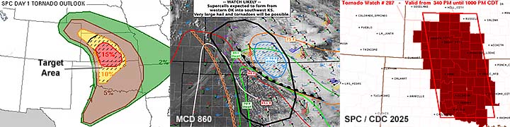
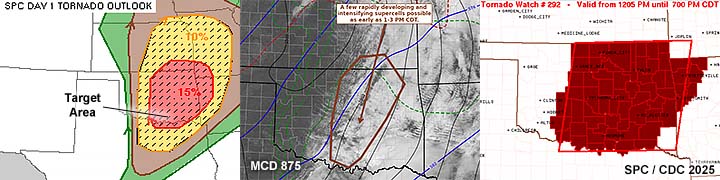
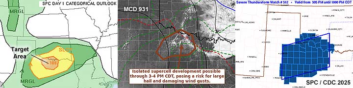
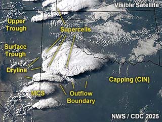
1). Apr 28, 6:00 PM - Observation of a severe thunderstorm from west of Vernon, Texas, near Highway 287 in Wilbarger County, and northeastward to near Tipton, Oklahoma just west of Highway 183 and SR 5 in Tillman County. The storm was an LP supercell storm, which initiated and split west of Vernon, and accelerated across the Red River with both splits becoming elevated and weakening. The storm contained golfball sized hail but the core was not penetrated. Frequent lightning and 30 MPH winds were experienced east of the storm, which had a supercell appearance during its early stages. Conditions causing the storms were surface heating, a dryline, low pressure trough, and an upper trough. Documentation was digital stills and HD video. A 2022 Jeep Renegade was used to chase the storm. A tornado watch was also valid for the area until 11 PM CDT.
2). Apr 28, 8:30 PM - Observation of a severe thunderstorm from near Odelle and White City in Wilbarger County, Texas and just south of the Red River near Highway 283. The storm was an LP supercell storm on the south end of a cluster of strong and severe storms. This storm was highly sheared, and had a striking visual appearance at dusk. The core (containing nickel to golfball sized hail) was not penetrated. Occasional lightning and shifting winds were also noted under the storm, with a rotating wall cloud / brief funnels observed. Conditions causing the storms were surface heating, a dryline, outflow boundary, low pressure trough, and an upper trough. Documentation was digital stills and HD video. A 2022 Jeep Renegade was used to chase the storm. A tornado watch was also valid for the area until 11 PM CDT.
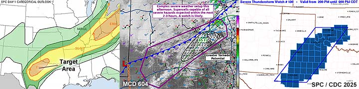
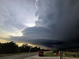
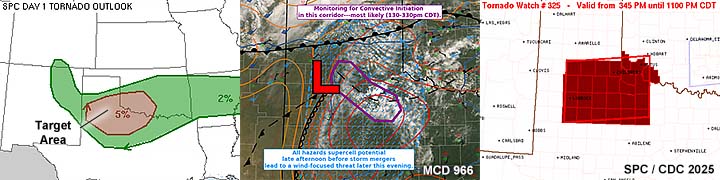
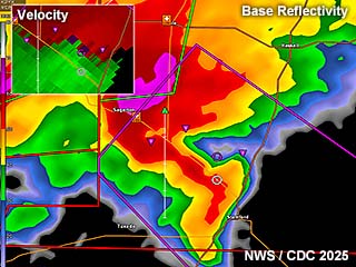
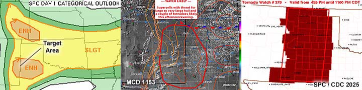
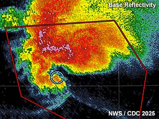
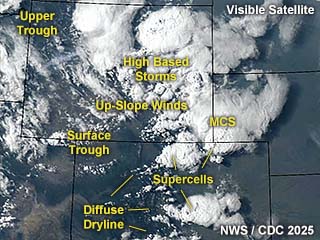
3). Apr 29, 5:00 PM - Observation and penetration of an extremely severe and tornadic thunderstorm in Stonewall County, Texas near Highway 83 north of Aspermont / Highway 380, and later on followed through Seymour, Texas by dusk. This storm was a powerful classic to HP supercell storm and was part of a cluster of severe storms and supercells. The storm was first observed with an impressive updraft, with a large bowl shaped lowering (some brief spin ups were barely visible underneath) that quickly became occluded. The storm was allowed to cross the road. Strong rotation was observed north of an RFD clear slot, with hail up to baseball sized along the roadside. Heavy rains, frequent lightning, and 50 MPH winds were encountered, despite the storm core (with hail sizes reported up to a staggering 5") not being penetrated at the time. Later on, after intercepting a tornado from the next storm (see entry below), I followed this storm back along Highway 277 to near Seymour. The storm had a large, rain-wrapped tornado (on radar) at the time. Extremely torrential rains, large hail, frequent lightning, and winds gusting probably over 100 MPH (probably wet RFD / embedded tornado) were observed in this area. Some structural damage to some buildings was noted, powerlines blown down, and some semi trailers were blown over along Highway 277. Conditions causing the storms were surface heating, a near stationary frontal boundary, low pressure trough, and an upper trough. Documentation was audio, digital stills, and HD video. A 2022 Jeep Renegade was used to chase the storm. A severe thunderstorm watch was initially valid for the area until 9 PM CDT, followed by a tornado watch valid until 1 AM CDT the next day.
4). Apr 29, 5:30 PM - Observation and penetration of an extremely severe and tornadic thunderstorm in Stonewall County, Texas near Highway 83 north of Aspermont / Highway 380. This storm was a powerful HP supercell storm and was developing southwest of the former tornadic storm mentioned in the entry above. I waited for the storm to approach and cross Highway 83, positioning myself so that the rain hook goes south of me and core passes north, placing me into the tight notch area of the storm (so called "bear's cage"). In this area, relatively rain free, a brief tornado, fully condensed was noted to my southeast, before 60+ MPH northerly winds and horizontal rain closed in. Large hail to 1" and frequent lightning was also noted with this storm. Fortunately, this ocurred over open rural country, so no damage was observed. I left this storm heading back south and east to catch the original storm re-intensifying and approaching Seymour (see entry above). Conditions causing the storms were surface heating, a near stationary frontal boundary, low pressure trough, and an upper trough. Documentation was audio, digital stills, and HD video. A 2022 Jeep Renegade was used to chase the storm. A severe thunderstorm watch was valid for the area until 9 PM CDT.
5). Apr 30, 6:30 PM - Observation of a strong to severe storm from Leon to Stonewall Counties, Texas, from near I-45 and buffalo and east to north of Crockett near Highway 287. The storm was a small classic / HP supercell storm that formed south of a massive cool pool of an MCS to the north. The storm produced some hail (core not penetrated), frequent lightning, 40 MPH winds, and heavy rain. A rotating wall cloud was noted with this storm north of Buffalo before the cool air from the outflow to the north undercut the storm. Conditions causing the storms were surface heating, a dryline to the west, outflow boundary, low pressure trough, and an upper trough. Documentation was digital stills. A 2022 Jeep Renegade was used to chase the storm. A severe thunderstorm watch was valid for the area until 8 PM CDT.
6). May 4, 2:30 PM - Observation and penetration of a severe thunderstorm northeast of Carlsbad, New Mexico near Eddy and Lea Counties on Potash Mines Road north of Highway 62. The storm was a high-based classic supercell storm, developing and moving northeastward across these remote areas. Occasional lightning, heavy rains, 40 MPH winds, and hail penny to quarter sized was observed near the core of this storm. Conditions causing the storms were surface heating, a dryline to the west, up-slope wind flow, low pressure trough, and an upper trough. Documentation was digital stills and HD video. A 2022 Jeep Renegade was used to chase the storm. A severe thunderstorm watch was also valid for the area until 9 PM MDT.
7). May 4, 6:00 PM - Observation of a severe thunderstorm in Winkler County, Texas along SR 18 south of Kermit. The storm was a high-based LP supercell. Occasional lightning, light rain, 35 MPH winds, and small hail was observed with this storm. The main core was not penetrated. Conditions causing the storms were surface heating, up-slope wind flow, low pressure trough, and an upper trough. Documentation was digital stills and HD / 4k video (time-lapse). A 2022 Jeep Renegade was used to chase the storm. A severe thunderstorm watch was also valid for the area until 10 PM CDT.
8). May 4, 8:00 PM - Interception and observation of a very severe thunderstorm in Loving County, Texas from near Mentone along SR 302 and to the west of Kermit in Winkler County. The storm was a powerful classic supercell. The core of this storm was not penetrated (hail probably to baseball sized). The storm was also producing frequent lightning. Inflow winds southeast of the storm were gusting over 50 MPH. The storm also had a very striking visual appearance, with inflow banding, striations, and a "stacked plates" effect visually. Conditions causing the storms were surface heating, a dryline retreating to the west, up-slope wind flow, low pressure trough, and an upper trough. Documentation was digital stills and HD / 4k video (including time-lapse). A 2022 Jeep Renegade was used to chase the storm. A severe thunderstorm watch was also valid for the area until 10 PM CDT.
9). May 5, 5:00 PM - Observation and penetration of a severe thunderstorm north of Odessa, Texas in Ector County and near Highway 385 and SR 338. This storm was a classic supercell storm. The storm produced mainly hail, with penny sized hail (probably larger farther north) noted in the core north of Odessa. The storm also produced occasional lightning, heavy rains, and 50 MPH winds. The storm also had a pronounced rain-free base, and small wall cloud, before being under cut by outflow moving NE to SW. Conditions causing the storms were surface heating, boundary interactions, low pressure trough, and an upper trough. Documentation was digital stills and HD video. A 2022 Jeep Renegade was used to chase the storm. A tornado watch was also valid for the area until 9 PM CDT.
10). May 6, 11:00 AM - Observation and penetration of a severe thunderstorm from near Rosebud, Texas in Falls County and near SR 53 and southeastwards towards Calvert along SR 6 in Robinson County. This storm (HP supercell) was formerly tornado warned, very early in the day, and got absorbed in an MCS storm cluster / line moving in from the west. Conditions encountered were 60 MPH winds, heavy rains, occasional lightning, and small hail. A rain-wrapped QLCS tornado near Cameron took aim on Calvert, but dissipated before reaching that location near SR 6. Conditions causing the storms were surface heating, boundary interactions, low pressure trough, and an upper trough. Documentation was digital stills and HD video. A 2022 Jeep Renegade was used to chase the storm. A tornado watch was also valid for the area until 9 PM CDT.
11). May 14, 7:00 PM - Observation and penetration of a very severe and tornadic thunderstorm from south of North Platte (near Wellfleet), Nebraska and Highway 83 in Lincoln County and westward near I-80 to the south of Hershey. The storm was a merger of two supercell storms, with the western storm becoming tornadic. A persistent land-spout was observed south of Hershey, which lasted at least a half hour. Large hail to golfball sized was also encountered with the storm core(s). Another large funnel was also noted north of the land-spout in the notch of the supercell west of North Platte, with the land-spout tornado descending from the flanking line. The storm also had a striking visual appearance (stacked plates effect). Frequent lightning and heavy rain was also encountered. No damage was observed since the tornado remained over rural areas. Conditions causing the storms were surface heating, boundary interactions, a dryline, low pressure system, and an upper trough. Documentation was digital stills, audio, and HD / 4k video. A 2022 Jeep Renegade was used to chase the storm. A severe thunderstorm watch was also valid for the area until 11 PM CDT.
12). May 16, 4:30 PM - Interception and indirect penetration of an extremely severe and tornadic thunderstorm from near Bell City in Stoddard County and west of Sikeston, Missouri in Scott County, from west of Highway 61 and west of I-55. The storm was a classic cyclic supercell, and was first encountered near and south of Bell City. The storm was eventually followed through Cairo, Illinois via I-57 and SR 286 and as far as Peducah, Kentucky (terrain is challenging there with trees and the tributaries of the Ohio / Mississippi river confluences. The storm produced at least two tornadoes while it was being observed in Scott County. One tornado was a dusty multi-vortex tornado southeast of Bell City, then another large cone to the north of Sikeston. These tornadoes caused downed trees, and structural damage to a home and farm structures. The storm also produced hail to 1” (core was not penetrated directly), heavy rains, winds well over 70 MPH (especially RFD), and frequent lightning with close hits. The storm also had a striking visual appearance, with striated updraft and impressive RFD clear slot with the tornado visible below it. Conditions causing the storms were surface heating, boundary interactions, a pacific cold front, low pressure trough, and an upper trough. Documentation was digital stills, audio, and HD / 4k video. A 2022 Jeep Renegade was used to chase the storm. A tornado watch was also valid for the area until 7 PM CDT.
13). May 16, 6:30 PM - Interception and observation of a severe and tornadic thunderstorm from west of Mounds in Pulaski County, Illinois and west of I-57 and near Old US 51. This storm was another supercell storm, which was initially classic mode, then evolved to HP. Visibility was poor given the wooded terrain, but a brief view of a weak tornado becoming rain-wrapped was noted. No damage was observed. The storm also produced an eerie “tornado fog” west of Mounds. The storm also produced some small hail, as the core was not directly penetrated. Heavy rains, 60 MPH winds, and extremely frequent lightning with numerous close hits was also encountered. Conditions causing the storms were surface heating, boundary interactions, a pacific cold front, low pressure trough, and an upper trough. Documentation was digital stills and HD / 4k video. A 2022 Jeep Renegade was used to chase the storm. A tornado watch was also valid for the area until 7 PM CDT.
14). May 17, 7:00 PM - Observation of a strong thunderstorm between Clinton and Elk City, Oklahoma and south of I-40 in Washita County. The storm was a short-lived, highly sheared LP supercell storm, which quickly weakened. The storm produced some hail but the core was not penetrated. The storm had an anticyclonic updraft - Confirmed with time-lapse - Before weakening via down-scaling and becoming elevated. Conditions causing the storms were surface heating, a warm front, dryline to the west, low pressure trough, and an upper trough. Documentation was digital stills and 4k video (time-lapse). A 2022 Jeep Renegade was used to chase the storm. A tornado watch was also valid for the area until 7 PM CDT.
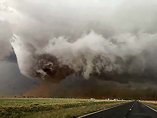
15). May 18, 6:00 PM - Interception and direct penetration of an extremely severe and tornadic thunderstorm from just southeast of Higgins, Texas, and northeastward past Arnett, Oklahoma, mainly along and near Highway 60 from Libscomb (TX) to Ellis County (OK). The storm was a powerful cyclic (LP / classic) supercell storm. The storm produced at least 5 tornadoes, all of which were observed, including a significant one at close-range barely missing Arnett. Tree damage was noted with this storm, as well as some ground scouring. Giant hail was encountered with this storm, with stones up to 3 inches, damaging the vehicle windshield with the tornado in progress west of Arnett. 60+ MPH RFD winds were also encountered, along with moderate rain and frequent lightning. The storm eventually evolved to LP mode from near Arnett to west of Sharon, and subsequently weakened via down-scaling near dusk. Conditions causing the storms were surface heating, a dryline, a warm front, low pressure trough, and strong upper trough. Documentation was digital stills, audio, and HD / 4k video. A 2022 Jeep Renegade was used to chase the storm. A tornado watch was also valid for the area until 10 PM CDT.
16). May 19, 5:00 PM - Observation and penetration of strong to severe thunderstorms from near Love County, Oklahoma and southward to near Gainseville in Cooke County, Texas near and west of I-35 and south of Highway 70 near the Red river. This storm was an MCS storm cluster with some supercell storms embedded in / ahead of it. These storms were outflow dominated Conditions encountered were 60 MPH winds, heavy rains, frequent lightning, and hail to 1". Conditions causing the storms were surface heating, a dryline, front / boundary interactions, low pressure trough, and an upper trough. Documentation was digital stills and HD / 4k video. A 2022 Jeep Renegade was used to chase the storm. A tornado watch was also valid for the area until 7 PM CDT.
17). May 22, 6:00 PM - Interception and observation of a very severe thunderstorm from near Wichita County, Texas and Highway 281, and south and southeast towards Palo Pinto County north of I-20 west of SR 337. The storm was a long-track classic to LP supercell storm. Rotating all clouds and funnels were noted with this storm, but no tornadoes touched down. The storm core, not penetrated, had hail exceeding 2". Other conditions encountered were light rain, 50 MPH winds, and hail to nickel sized. Frequent lightning was also observed. This supercell also had a striking visual appearance, especially late in its evolution. With a "stacked plates" presentation. Time-lapse video also revealed anticyclonic (clockwise) rotation on the south couplet of the storm low-level mersocyclone, with a well developed RFD north of that. The mid level rotation was cyclonic. Conditions causing the storms were surface heating, outflow boundary, stationary front, low pressure trough, and an upper trough. Documentation was digital stills and HD / 4k video. A 2022 Jeep Renegade was used to chase the storm. A severe thunderstorm watch was also valid for the area until 10 PM CDT.
18). May 24, 9:30 PM - Interception and observation of a severe thunderstorm northwest of Strong City in Roger Mills County, Oklahoma and south of Roll along Highway 283. The storm was a classic supercell storm, developing at dusk, and briefly intensifying after dark. The storm eventually weakened via down-scaling. The storm core was not penetrated. Frequent lightning was also observed with this storm, as well as an RFD slot and briefly rotating wall cloud / notch area. Conditions causing the storm was surface heating, a dryline, stationary / warm front, low pressure trough, and an upper trough to the west. Documentation was digital stills and HD / 4k video. A 2022 Jeep Renegade was used to chase the storm. A tornado watch was also valid for the area until 4 AM CDT the next day.
19). May 25, 5:00 PM - Interception and indirect penetration of an extremely severe and tornadic thunderstorm from near SR 70 and Highway 62 in Matador in Motley County, Texas and points south and east along Highway 83 to Dickens and Guthrie in King County. The storm was a powerful classic to HP supercell storm. The storm had an area of rotation noted west of Roaring Springs, with a near touch-down there (no tornado). A poor contrast and brief view of a possible cone tornado, with wet RFD slot, was noted between Dickens and Guthrie looking northward on Highway 82. Conditions encountered were heavy rain, frequent lightning, 60 MPH winds, and hail to 1". The main core was not penetrated - Which contained hail exceeding 5" (and a storm top of 63,000 feet)! Conditions causing the storm was surface heating, a stationary front / outflow boundary, low pressure trough, and an upper trough. Documentation was digital stills and HD / 4k video. A 2022 Jeep Renegade was used to chase the storm. A tornado watch was also valid for the area until 11 PM CDT.
20). May 25, 7:30 PM - Interception and direct penetration of a very severe and tornadic thunderstorm from near Aspermont along Highway 380 in Stonewall County, Texas and southeast to near SR 6 and Highway 277 in Haskell County near Stamford. The storm was a powerful HP storm developing on the south end of a cluster of severe storms and supercells, and initially was outflow dominant. The core was penetrated northwest of Sagerton, with completely horizontal / violent rain, frequent lightning, hail to 1.5", and winds gusting over 70 MPH. The storm approached Jones and Haskell counties near Stamford, and a leading-edge mesocyclone was noted there. Another core-punch was executed just west of Stamford, with a brief tornado observed concurrent with a gustnado and well-defined RFD / notch. Winds in this area gusted near 100 MPH, with blowing dust, torrential rains (from the RFD hook), hail to 1", and frequent lightning with close hits. The tornadic area became embedded in the line of storms as evolution to an MCS occurred as the storm was between Avoca and Stamford. Conditions causing the storm was surface heating, a stationary front / outflow boundary, low pressure trough, and an upper trough. Documentation was digital stills and HD / 4k video. A 2022 Jeep Renegade was used to chase the storm. A tornado watch was also valid for the area until 11 PM CDT.
21). May 26, 5:00 PM - Observation and indirect penetration of an extremely severe and possible tornadic thunderstorm from its point of initiation just southeast of San Angelo, Texas in Tom Green / Schleicher counties and Highways 277, 190, and 83. The storm was followed southeast past Menard and to Mason via Highway 87, and as far as Fredericksburg in Gillespie County. The storm was a classic supercell that evolved to HP mode. The core was not directly penetrated, except for strong RFD / former embedded tornadic winds near Cherry Springs. A possible tornado was observed when the storm was northwest of Menard. The storm evolved to HP after that, with hail almost 6" confirmed after passage of the storm core (the ICECHIP research team). Other conditions encountered were torrential rains, 1" hail, 70+ MPH winds, and very frequent lightning with numerous close hits (researcher Reed Timmer reported that his vehicle was hit by lightning). The storm mainly stayed over rural areas. Conditions causing the storm was surface heating, a quasi-stationary outflow boundary, low pressure trough, and an upper trough. Documentation was digital stills and HD / 4k video. A 2022 Jeep Renegade was used to chase the storm. A tornado watch was also valid for the area until 10 PM CDT.
22). May 27, 5:00 PM - Interception and penetration of severe thunderstorms southwest of Fort Stockton, Texas in Brewster County and northwest of Marathon along Highways 90 and 67. The storms were a cluster of supercell storms. Conditions encountered were heavy rain, occasional lightning, 60 MPH winds, and hail to 1". Conditions causing the storms were surface heating, up-slope wind flow, a low pressure trough, and a departing upper trough. Documentation was digital stills and HD / 4k video (including time-lapse). A 2022 Jeep Renegade was used to chase the storm. A severe thunderstorm watch was also valid for the area until 11 PM CDT.
23). May 28, 4:30 PM - Interception and observation of a severe thunderstorm near Lycan Colorado in Baca County and west of Johnson City in Kansas (Stanton County) along SR 89. The storm was a supercell storm on the northeast side of a large cluster of strong and severe storms. Looking southeast an area of rotation and brief funnel cloud was observed. The core was not penetrated and the storm complex was abandoned for another storm farther north. Winds of 30 MPH, occasional lightning, and light rain was also encountered. Conditions causing the storm was surface heating, up-slope wind flow, a warm front, low pressure trough, and an approaching upper trough. Documentation was digital stills and HD / 4k video (including time-lapse). A 2022 Jeep Renegade was used to chase the storm. A tornado watch was also valid for the area until 9 PM MDT / 10 PM CDT.
24). May 28, 5:30 PM - Interception and indirect penetration of a severe thunderstorm between Sheridan Lake and Cheyenne Wells, Colorado near Highway 385 and SR 96 in Kiowa County. The storm was a supercell storm moving southeastward, but was just north of a warm frontal boundary. The storm had strong rotation, and a funnel with dust was observed near Cheyenne Wells. The storm was outflow dominant, and on the cool side of the warm front. It was HP in nature and in poor visibility (fog and low base). Conditions encountered were occasional lightning, 60 MPH winds, hail to 1”, and very heavy rains. Conditions causing the storm were surface heating, a warm front, low pressure trough, and an upper trough. Documentation was digital stills and HD / 4k video (including time-lapse). A 2022 Jeep Renegade was used to chase the storm. A tornado watch was also valid for the area until 9 PM MDT / 10 PM CDT.
25). June 2, 5:00 PM - Interception and observation of a very severe thunderstorm near Kimball County, Nebraska off I-70 and west of SR 71 (west of Sidney). The storm was a powerful supercell storm, albeit HP in nature and outflow dominant. The core of this storm was not directly penetrated. Conditions observed were light rain, small hail, frequent lightning, and 40 to 50 MPH winds. The storm had a striking visual appearance as well, with a multi-tiered gust front noted with the RFD surge, with rotating wall cloud. Conditions causing the storm were surface heating, post-frontal up-slope wind flow, a low pressure area, and an upper trough / low. Documentation was digital stills and HD / 4k video (including time-lapse). A 2022 Jeep Renegade was used to chase the storm. A severe thunderstorm watch was also valid for the area until 8 PM MDT / 9 PM CDT.
26). June 2, 6:30 PM - Observation and penetration of a very severe thunderstorm in Weld and Logan counties, Colorado near SR 71 and SR 14. The storm was a powerful LP to classic supercell storm. The core of this storm was penetrated late in its life cycle near Sterling and along I-76. Conditions observed were heavy rain, hail to 1.5", frequent lightning, and 60 MPH winds. The storm had a striking visual appearance as well, especially during its early stages over Weld County, with a "mothership" / "stacked-plates" presentation. A wall cloud with pronounced RFD clear-slot and large funnel / brief tornado observed near Stoneham off SR 14. The "bears cage" of this storm was entered, with rotating rain / hail all around with the wall cloud / funnel in the enclosed rain-free area. The storm became HP near Sterling, then evolved to a bow segment and weakened afterwards. Conditions causing the storm were surface heating, post-frontal up-slope wind flow, a low pressure area, and an upper trough / low. Documentation was digital stills and HD / 4k video (including time-lapse). A 2022 Jeep Renegade was used to chase the storm. A severe thunderstorm watch was also valid for the area until 8 PM MDT / 9 PM CDT.
27). June 2, 9:30 PM - Penetration of a strong thunderstorm northeast of Brush, Colorado in Morgan County along I-76 and near Hillrose. The storm was an intense elevated (over cool pool) line / bow segment north of a supercell west of Akron to the south. This storm had very heavy rains, small hail, 40 MPH winds, and very frequent lightning. Conditions causing the storm were surface heating, post-frontal up-slope wind flow, a low pressure area, and an upper trough / low. Documentation was digital stills. A 2022 Jeep Renegade was used to chase the storm. A severe thunderstorm watch was also valid for the area until 8 PM MDT / 9 PM CDT.
28). June 4, 7:30 PM - Observation and penetration of a severe thunderstorm from southeast of Santa Rosa in Guadalupe County, New Mexico along SR 91 south of I-40 and eastward to near House in Quay County and near SR 156. The storm was an LP to classic supercell storm. Conditions encountered were large hail (exceeding 1"). which covered the ground at times - Especially in Quay County. The core of the supercell was penetrated twice. Frequent lightning, heavy rains, and 60 MPH winds were also encountered. Conditions causing the storm were surface heating, post-frontal up-slope wind flow, a low pressure trough, and an upper trough. Documentation was digital stills and HD / 4k video (including time-lapse). A 2022 Jeep Renegade was used to chase the storm. A severe thunderstorm watch was also valid for the area until 11 PM MDT / 12 AM CDT.
29). June 4, 9:30 PM - Observation of a very severe and possibly tornadic thunderstorm south of Adrian and southwest of Vega, Texas in Oldham County and near SR 214. The storm was an HP supercell evolving to a powerful bow segment. The core was not penetrated, which had large hail and destructive winds. The lightning from this storm was continuous and spectacular - Illuminating the impressive structure of the storm, with an RFD gust front and striated updraft and wall cloud. A brief tornado was observed under the wall cloud in the storm notch looking northwest from south of Adrian before hastily bailing east away from the storm. Moderate rain, 50 MPH winds, and small hail was also encountered. Conditions causing the storm were surface heating, post-frontal up-slope wind flow, a low pressure trough, and an upper trough. Documentation was digital stills and HD / 4k video (including time-lapse). A 2022 Jeep Renegade was used to chase the storm. A severe thunderstorm watch was also valid for the area until 11 PM MDT / 12 AM CDT.
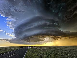
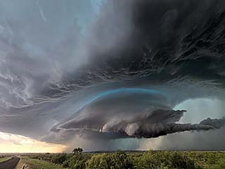
30). June 5, 5:30 PM - Interception, observation, and indirect penetration of an extremely severe and powerful tornadic thunderstorm from near Bailey and Cochran Counties, Texas, near and along SR 114, and east past Morton and eventually into Lubbock. This storm was a violent cyclic supercell, mainly classic, and evolved to HP later in its life-cycle. The main core of this storm was not directly penetrated. At least 10 tornadoes were observed with this storm. The first few were looking west towards Causey, New Mexico from Bailey County, Texas. Then a major storm cycle northwest and north of Morton caused a few more tornadoes, ranging from small dust swirls under a funnel to a massive wedge tornado - loaded with red dust - west of Morton, Texas with a satellite tornado going around it! This wedge passed north of Morton, and was observed from close range (quarter mile or less) on SR 214. In this area, 70 MPH RFD winds were encountered, with debris blowing across the road looking north. An audible roar could be heard. Baseball sized hail was also noted at this time. The storm was observed again northwest of Levelland, and eventually eastward into Lubbock. On the NW side of town, just south of Shallowater and west of Highway 84, the storm was HP but I was offered a view into the notch of the storm. Light (despite the sun not setting in at least another hour) was low, almost like chasing a storm at night. A few dusty tornadoes were noted (very poor contrast) looking west from this area. Finally, power flashes appeared to my SW, and a large wedge tornado appeared before becoming rain wrapped by 7:30 to 8 PM CDT. Fortunately the supercell weakened substantially before going over Lubbock. The storm went from HP to a bow segment at dusk, and continued southeast. Other conditions observed were torrential rains, frequent lightning, 70 MPH wind gusts and additional hail to 1". Wind damage and flash flooding was also observed. Conditions causing the storm were surface heating, a warm front, low pressure trough, dryline, and an upper trough. Documentation was digital stills and HD / 4k video (including time-lapse). A 2022 Jeep Renegade was used to chase the storm. A tornado watch was also valid for the area until 11 PM CDT.
31). June 6, 5:30 PM - Observation and penetration of an extremely severe and tornadic thunderstorm from near Cochran County, Texas near SR 125, and east and southeast past Whiteface and Sundown to near Terry County and Lakeview / Slide near Highways 62 and 87 and eventually along Highway 380 in Lynn County. The storm was followed from initiation (just west of the Texas / New Mexico border south of Bluit). The storm began evolving to classic with wall-cloud formation between Bledsoe and Whiteface, and became tornadic from there and eastwards towards Sundown. The storm became HP near Slide (Terry County) and evolved to a powerful bow segment eastward past Highway 87. This supercell was also cyclic. At least 4 tornadoes were observed with this storm, including a multi-vortex broad tornado near Whiteface, and a thin rope northwest of Sundown. This supercell picked up a lot of dust, staining the sky an eerie red color - Near the storm core, where hail exceeding 2" was observed smashing into the road ahead of the chase vehicle. The storm also had a striking visual appearance, especially when viewed from the east during its HP stages, with a "stacked plates" presentation. Torrential rains, 60+ MPH winds, and frequent lightning (with some close hits) was also encountered. Conditions causing the storm were surface heating, a stationary outflow boundary, low pressure trough, dryline, and an upper trough. Documentation was digital stills and HD / 4k video (including time-lapse). A 2022 Jeep Renegade was used to chase the storm. A tornado watch was also valid for the area until 11 PM CDT.
32). June 7, 5:30 PM - Interception and direct penetration of a severe thunderstorm from northwest of Grenville in Union County, New Mexico and Highway 87 and SR 453, and points southeastwards to near Hayden and SR 402 / 102. The storm was an LP to classic supercell storm, followed from its point of initiation near Des Moines and southeastwards to just west of the TX / NM border. Large hail to 1.25" was encountered with the core of this storm south of Grenville and near Hayden. Hail covered the ground in some cases, with the landscape and roadway becoming "winter like" (white). The storm also had 60 MPH winds, heavy rain, and frequent lightning with close hits. A rotating wall cloud was also noted with this storm. Conditions causing the storm were surface heating, up-slope wind flow, a low pressure trough, and an upper trough. Documentation was digital stills and HD / 4k video (including time-lapse). A 2022 Jeep Renegade was used to chase the storm. A severe thunderstorm watch was also valid for the area until 9 PM MDT / 10 PM CDT.
33). June 7, 8:00 PM - Interception and direct penetration of a severe thunderstorm from south of Miera in Union County, New Mexico and SR 102, and points southeastwards to near Nara Visa in Quay County and SR 402 / Highway 54. The storm was an LP to classic supercell storm, Large hail to 2" was encountered with the core of this storm between Bueyeros and Hayden. This storm also had an incredible visual presentation, with a "stacked plates" (or "mothership") appearance, especially during its LP and later stages. A rotating wall cloud, RFD, and brief funnel was also observed. Other conditions encountered were 60 MPH winds, light to moderate rain, and frequent lightning with close hits. Conditions causing the storm were surface heating, up-slope wind flow, a low pressure trough, and an upper trough. Documentation was digital stills and HD / 4k video (including time-lapse). A 2022 Jeep Renegade was used to chase the storm. A severe thunderstorm watch was also valid for the area until 9 PM MDT / 10 PM CDT.
34). June 8, 5:00 PM - Observation and penetration of an extremely severe and possible tornadic thunderstorm from south of Highway 287 in Armstrong County (near Claude and Clarendon), and points southeast past Peducah from SR 70 and Highway 62 through Cottle County, Texas. The storm was a powerful classic to HP supercell storm. The core of this storm had hail exceeding 4" and 100 MPH winds. The core was penetrated near Peducah as the storm was weakening, and 60 MPH winds and hail to golf-ball sized observed there, shredding trees and covering the ground near a tractor shop. While passing between Lakeview and Estelline from near the Red River and Highway 86, the core was indirectly penetrated, with powerful wet RFD winds of up to 80 MPH, 2" hail, horizontal heavy rains, and frequent lightning (with some close hits). A possible brief tornado was observed in low contrast while looking into the HP notch of the storm, with exceptional visual structure ("stacked plates" / "mothership") on the eastern side of the supercell. The storm eventually evolved to a large bow segment, producing winds over 60 MPH over a wide swath, and extremely frequent lightning, and was tracked until near Seymour off Highway 82 in Baylor County. Conditions causing the storm were surface heating, a dryline, a low pressure trough, and an upper trough. Documentation was digital stills and HD / 4k video (including time-lapse). A 2022 Jeep Renegade was used to chase the storm. A PDS (particularly dangerous situation) severe thunderstorm watch was also valid for the area until 11 PM CDT.
35). June 13, 2:30 PM - Observation and indirect penetration of strong to severe thunderstorms from near Chugwater in Platte County, Wyoming, and northward on I-25 to near Glendo. These storms were a multi-cell line / cluster of strong and severe storms. Conditions encountered were heavy rains, frequent lightning, 60 MPH winds, and small hail to nickel sized. Conditions causing the storm were surface heating, up-slope wind flow, a low pressure trough, and an upper trough. Documentation was digital stills. A 2022 Jeep Renegade was used to chase the storm. A severe thunderstorm watch was also valid for the area until 10 PM MDT.
36). June 13, 8:00 PM - Interception and penetration of a severe thunderstorm north of Gillette, Wyoming in Campbell County and near SR 16 and east of Highway 16. The storm was one of two LP supercell storms developing in the late afternoon / early evening. The storm had a striking visual appearance before down-scaling. Conditions encountered were heavy rains, frequent lightning, 50 MPH winds, 1" hail. Conditions causing the storm were surface heating, up-slope wind flow, a stationary front, low pressure trough, and an upper trough. Documentation was digital stills. A 2022 Jeep Renegade was used to chase the storm. A severe thunderstorm watch was also valid for the area until 10 PM MDT.
37). June 14, 4:30 PM - Observation of a strong thunderstorm in Campbell County, Wyoming from near Bill and south of Wright and near SR 59. The storm was a high-based LP storm, which undergone down-scaling afterwards. The core was not penetrated. A wall cloud was observed with this storm before it weakened. Other conditions encountered were 40 MPH winds, light rain, and frequent lightning. Conditions causing the storm were surface heating, up-slope wind flow, a low pressure trough, and an upper trough. Documentation was digital stills and time-lapse 4k video. A 2022 Jeep Renegade was used to chase the storm. A severe thunderstorm watch was also valid for the area until 10 PM MDT.
38). June 15, 4:30 PM - Interception, indirect penetration and observation of severe thunderstorms in Morgan County, Colorado near SR 71 and Highway 34. The storm was part of two high-based supercells that merged into a multi-cell cluster. A possible land-spout tornado was observed under an updraft base to the west of Brush with the west-most supercell. Other conditions observed were frequent lightning, heavy rain, small hail, and 40 MPH winds. Conditions causing the storms were surface heating, up-slope wind flow, a low pressure trough, and an upper trough. Documentation was digital stills and HD / 4k video. A 2022 Jeep Renegade was used to chase the storm. A severe thunderstorm watch was also valid for the area until 11 PM MDT (12 AM CDT the next day).
39). June 15, 7:30 PM - Observation and indirect penetration of severe thunderstorms from along I-76 near Julesburg in Sedgwick County, Colorado, and eventually into Ogallala, Nebraska in Keith County. The storm was a powerful line-segment / multi-cell bow with a high base. The leading edge had a multi-tiered shelf cloud, and striations were noted in an updraft near Julesburg. I stayed ahead of the bow segment, until I got to Ogallala. There, winds exceeding 60 MPH were observed with the passage of the gust front. Small hail, frequent lightning, and heavy rain was also observed. Conditions causing the storms were surface heating, up-slope wind flow, a low pressure trough, and an upper trough. Documentation was digital stills and HD / 4k video (including time-lapse). A 2022 Jeep Renegade was used to chase the storm. A severe thunderstorm watch was also valid for the area until 11 PM MDT (12 AM CDT the next day).
40). June 16, 7:30 PM - Observation and penetration of an extremely severe and tornadic thunderstorm in Lincoln County, Nebraska to the northwest of Wellfleet and Highway 83, and near and south of SR 23. The storm was a violent cyclic LP to classic supercell storm. At least 4 tornadoes were observed with this storm, with the last one being a significant slow-moving stove-pipe which remained on the ground for at least 20 minutes. Hail to baseball sized was also encountered north of the tornadoes on SR 23, with another shattered left windshield as a result. The first tornadoes were under an LP supercell base, with no visible RFD, and looked like a funnel with dust swirl under it. At one point a second tornado was observed west of the main one. Then next two were elephant trunk tornadoes, and finally the stove-pipe. The tornadoes did not hit any major structures, and remained over rural areas. Some ground scouring, debarked trees, and snapped powerlines were observed after the main last tornado roped out. A wooded area also was completely stripped to bare tree stumps. Other conditions encountered were frequent lightning with many close hits, light to moderate rain, and 60 to 70 MPH winds (mainly RFD). This storm also had a very striking visual appearance, with a "stacked-plates" or "mother-ship presentation. The RFD cut came in during the latter parts of the storm cycle, with evolution to classic mode and rope-out of the large tornado. Conditions causing the storms were surface heating, a stationary frontal boundary, low pressure trough, and an upper trough. Documentation was digital stills and HD / 4k video (including time-lapse). A 2022 Jeep Renegade was used to chase the storm. A severe thunderstorm watch was also valid for the area until 11 PM CDT.
41). June 16, 10:30 PM - Penetration of severe thunderstorms between Atwood and Colby, Kansas along SR 25 in Rawlins County. The storms were part of a multi-cell cluster of strong and severe storms. Extremely frequent to continuous lightning was observed with these storms, as well as nickel-sized hail, heavy rains, and 60 MPH winds. An unusual heat burst was also encountered with a dry downdraft from one of these storms north of Atwood, Kansas with temperatures going from the low 80s to low 90s (unusual for late night). Conditions causing the storms were surface heating, a low pressure trough, and an upper trough. Documentation was HD / 4k video. A 2022 Jeep Renegade was used to chase the storms. A severe thunderstorm watch was also valid for the area until 11 PM CDT.
42). June 17, 8:00 PM - Observation, interception, and penetration of a very severe and tornadic thunderstorm from Beaver County, Oklahoma near Elmwood and Highway 412, then south and east into Lipscomb County, Texas near Higgins and Highways 83 and 60 and west of Highway 283 in Oklahoma. The storm was a classic to high-precipitation supercell, with a very striking visual appearance, especially during its early stages. The storm evolved to HP as it reached Lipscomb county, and a large tornado was observed in the "bear's cage" of the HP storm south of Higgins at roughly 8 PM. Other conditions encountered were frequent lightning, hail to 2", violent (horizontal) rain, and winds gusting near 100 MPH (especially RFD). Tree damage was common with this storm, which fortunately remained over open rural areas. Conditions causing the storm was surface heating, a low pressure area, frontal boundary / dry-line interactions, and an upper trough. Documentation was digital stills, audio, and HD / 4k video (including time-lapse). A 2022 Jeep Renegade was used to chase the storms. A tornado watch was also valid for the area until 10 PM CDT.
43). June 18, 6:30 PM - Observation of a severe thunderstorm from southeast of Lawton and south of Pumpkin Center, Oklahoma in Comanche County along SR 65 and between SR 7 and SR 53. The storm was a classic supercell storm, albeit with broad rotation. The core of the storm, containing 60 MPH winds and 2" hail, was not penetrated. Other conditions observed were light rain, frequent lightning, and 40 MPH winds. The storm had a striated visual appearance during its intense phase before down-scaling, with rotating wall cloud (brief funnel noted) and RFD clear slot. Conditions causing the storms were surface heating, a stationary frontal boundary, a low pressure trough, and departing upper trough. Documentation was digital stills and HD / 4k video (including time-lapse). A 2022 Jeep Renegade was used to chase the storm. A severe thunderstorm watch was also valid for the area until 10 PM CDT.
44). June 20, 8:30 PM - Observation and indirect penetration of an extremely severe, violent, and tornadic thunderstorm near Spiritwood in Stutsman County, North Dakota, east of Jamestown and I-94, and to near Hastings on SR 1 in Barnes County. The storm was a classic and cyclic supercell, which started out LP and evolved to HP late in its life-cycle. At least four tornadoes were observed with this storm, starting with dust under a rotating cloud base / wall cloud, to a possible violent stove-pipe / wedge tornado near Spiritwood. Two additional tornadoes were observed southeast into Barnes County, one a highly-visible cone / elephant trunk tornado, and a large, partially rain wrapped tornado near Hastings. Major structural damage was observed with these tornadoes, including at least one home destroyed. The core of this storm, with 3" hail, was not penetrated. Other conditions encountered were heavy rains, winds gusting over 70 MPH (possible near 100 MPH in RFD), hail to 1", and frequent lightning with close hits. The supercell had a highly striated, and intimidating, visual appearance as well. Conditions causing the storm was surface heating, a stationary / warm frontal boundary, a low pressure trough, and upper trough. Documentation was digital stills, audio, and HD / 4k video (including time-lapse). A 2022 Jeep Renegade was used to chase the storm. A tornado watch was also valid for the area until 3 AM CDT the next day.
45). June 20, 10:30 PM - Observation and penetration of an extremely severe, violent, and tornadic thunderstorm in Cass and Ransom Counties, North Dakota, near Enderlin and Lisbon, from SR 46 / 32 and eastward on CR 27 eastwards. This after-dark supercell (during its encounter) was a cyclic and powerful classic to HP supercell. Large hail to golf-ball sized was encountered west of Enderlin before heading south on SR 32 into Lisbon. Powerful inflow winds was noted in this area, to 60 MPH, giving way to RFD winds. While heading east on CR 27 east of Lisbon and looking north towards Enderlin, a large wedge, possibly violent, tornado could barely be seen (illuminated by lightning). The storm also had an incredible visual structure, with tilted "slinky" and striated updraft, inflow bands, and RFD cut. Lightning was continuous with this supercell storm, and some close hits were observed. Heavy rain was also encountered during the risky core-punch of this storm west of Enderlin. Unfortunately, this storm caused major damage and two fatalities in Enderlin. A powerful derecho caught up with, and undercut this storm by about 11:30 PM CDT. 60 MPH winds, small hail, frequent lightning, and torrential rains were encountered with this version of the storm south of Fargo, albeit without a tornado threat. Conditions causing the storm was surface heating, a stationary / warm frontal boundary, a low pressure trough, and upper trough. Documentation was digital stills, audio, and HD / 4k video (including time-lapse). A 2022 Jeep Renegade was used to chase the storm. A tornado watch was also valid for the area until 3 AM CDT the next day.
46). June 22, 7:00 PM - Interception and indirect penetration of a very severe and tornadic thunderstorm from Marshall to Woods counties, Minnesota from near Holt and eastward to the northwest of Grygla, and near SR 89 and well north of SR 1 in heavily wooded terrain. The storm was a classic to HP supercell storm. The storm had a striking visual appearance, with low-level striations, RFD cut and full occlusion, and gust front. A multi-vortex tornado was noted to the northwest of Grygla in Woods County, tossing and downing trees. The core was not directly penetrated. Conditions encountered were sporadic lightning, heavy rains, and 60 MPH winds. The storm eventually evolved to an MCS / storm cluster of strong and severe storms, and moved across the international border into Canada near Beudette by evening. Conditions causing the storm was surface heating, a warm front, approaching cold front, a low pressure area, and an upper trough. Documentation was digital stills and HD / 4k video (including time-lapse). A 2022 Jeep Renegade was used to chase the storm. A tornado watch was also valid for the area until 10 PM CDT.
This concludes the chase log for the central US Plains for the main chase "expedition" of 2025 starting April 25 and ending on June 27, 2025. The summary includes a total of 46 observations, out of which there were 43 severe thunderstorms and 2 strong thunderstorms. Out of these thunderstorms, at least 44 possible tornadoes were observed, with 13 being significant. The main chase vehicle conducting this chase was a 2022 Jeep Renegade. All entries for the logs above are for the local time zone unless otherwise noted. This information was prepared exclusively for the National Weather service and the team of Skywarn storm spotters.
|
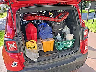
Packing up my vehicle prior to departure from South Florida on April 25. |
|
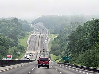
View heading west through Alabama on I-22 during the morning of April 26 (after spending the night of April 25 in Atlanta, Georgia). |
|
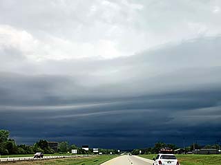
View of gust front of a non severe storm while entering Oklahoma on I-40 during the afternoon of April 26. |
|
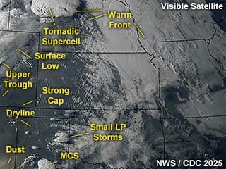
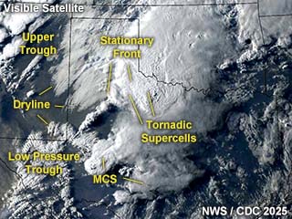
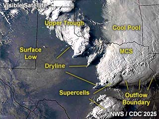
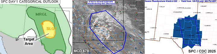
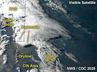
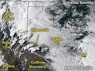
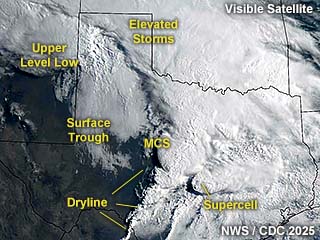
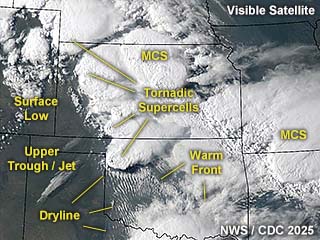
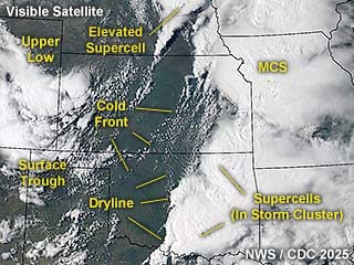
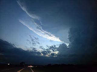
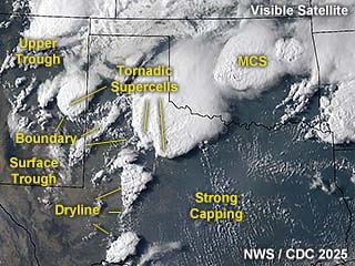
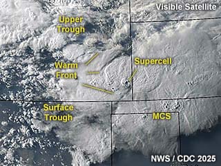
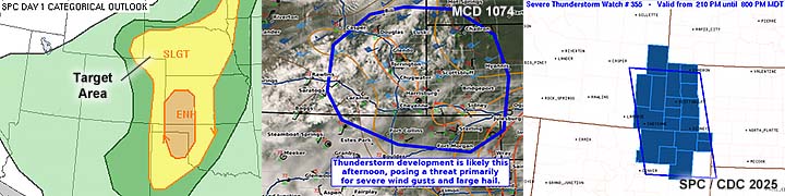
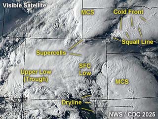
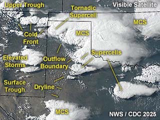
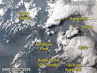
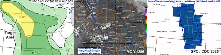
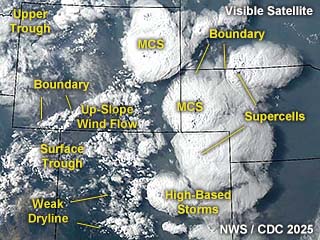
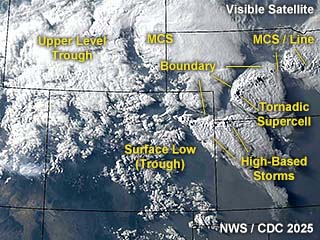
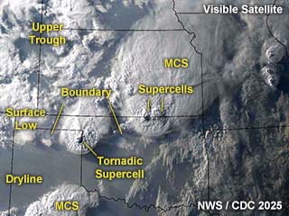
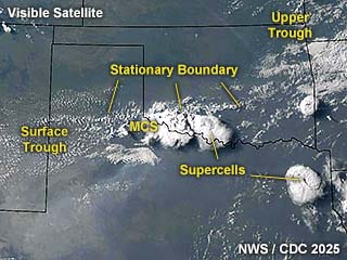
This is an annotated visible satellite just after 23z on April 27. A complicated and large severe weather setup stretches north to south on the left side of the image, with the only tornado-producing (cyclic supercell) storm of the day in the far north over north-central Nebraska. |
|
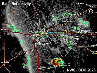
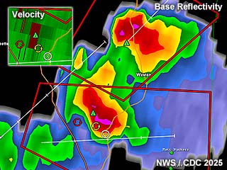
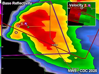
Base refelectivity image out of Amarillo around 6 PM CDT showing storms attempting to initiate southeast of Amarillo. This was in an extremely unstable atmosphere but a "capping" inversion prevented storms from being established (and eventually producing tornadoes given the strong shear in place). |
|
View of small LP supercell attempting to develop near Groom, Texas before being supressed by the strong cap, ending the chase day as a "bust". |
|
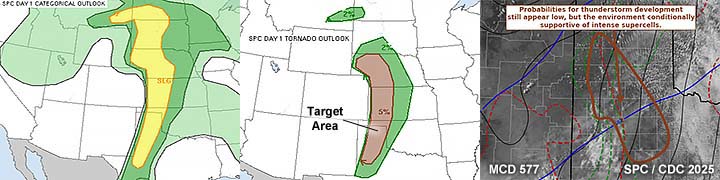
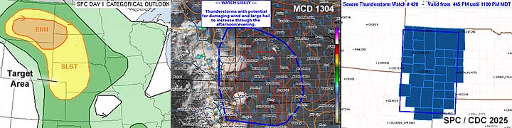
This is an annotated visible satellite just around 1z on April 29 showing the synoptic environment over the target area. Note the overshooting top lit by the dusk sunlight! |
|
Base refelectivity image out of Frederick, Oklahoma around 9 PM CDT showing storms, including a tornado-warned supercell, near the Red River. |

|
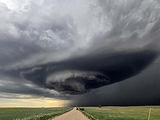
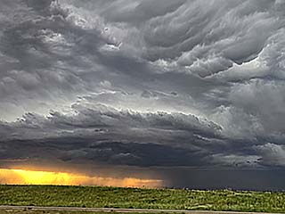
View of a tornado-warned LP supercell between Altus, Oklahoma and Vernon, Texas at dusk with incredible storm structure. |
|
This is an annotated visible satellite just around 0z on April 30 showing the synoptic environment over the target area. Supercell storms are developing over the Texas Caprock and hill country. |
|
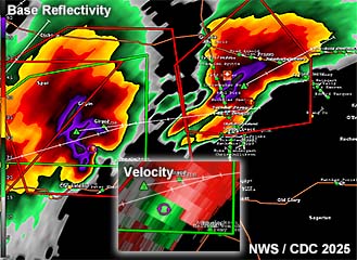
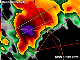
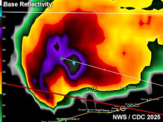
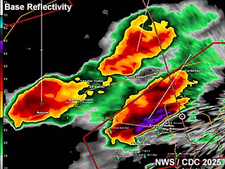
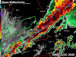
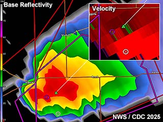
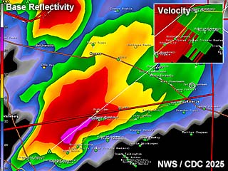
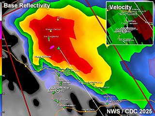
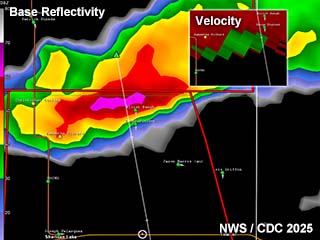
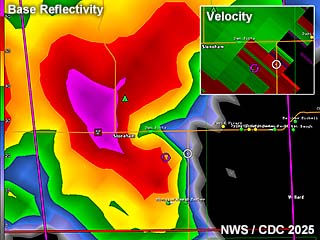
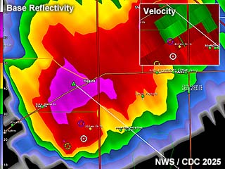
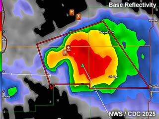
Base reflectivity image out of Dyess AFB in Texas around 5 PM CDT showing storms, including two tornado-producing storms north of Aspermont, Texas. The Doppler velocity is to the bottom center, and is for the supercell storm to the left in the image. |
|
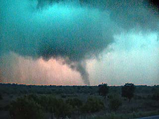
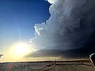
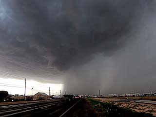
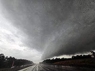
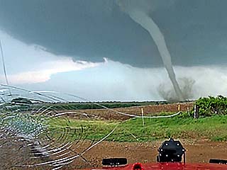
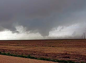
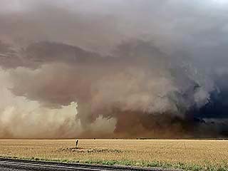
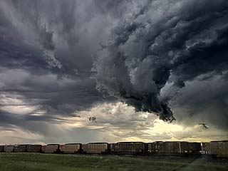
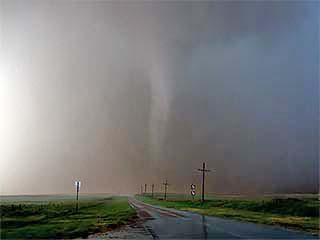
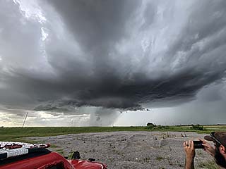
View of a brief tornado associated with a powerful HP supercell storm north of Aspermont, Texas at around 5 PM CDT. The view is to the south and I am inside the "bear's cage" of the supercell. |

|
Very large hail was produced by this supercell, exceeding baseball sized. This stone has melted considerably. |
|
This is an annotated visible satellite just around 0z on May 1 (evening of April 30) showing the synoptic environment over the target area. Supercell storms are developing ahead of a dryline and south of a large MCS over NE Texas. |
|
Base reflectivity image out of Fort Cavasos in Texas just before 7 PM CDT showing a supercell storm near Buffalo, Texas on the south end of a larger MCS. |
|
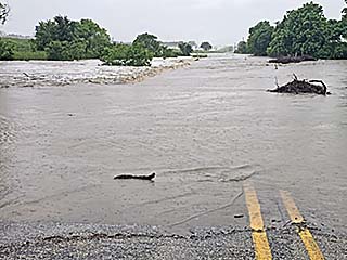
Severe flash flooding south of Gainesville, Texas off I-35 during the morning of April 30. |
|
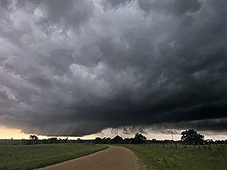
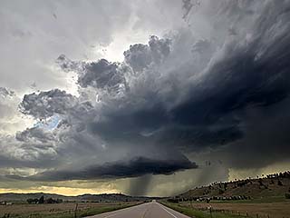
Rotating wall cloud north of Buffalo, Texas from a supercell storm late in the day on April 30. |
|
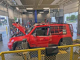
Vehicle maintenance (oil change) while in Plano, Texas on May 2, 2025. |
|
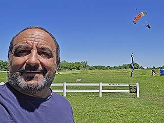
Skydiving at Skydive Spaceland (Dallas) near Whitewright, TX on May3. |
|
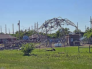
Damage from storms a few days prior near Seymour, Texas while driving from the Dallas area to Lubbock. |
|
This is an annotated visible satellite just around 0z on May 5 (evening of May 4) showing the synoptic environment over the target area. Supercell storms are developing in SE New Mexico and far western Texas in up-slope wind flow. |
|
Base reflectivity image out of Midland, Texas at roughly 8 PM CDT showing a supercell storm west of Kermit, Texas. |
|
Intense high-based supercell storm west of Kermit, Texas late in the day on May 4. |
|
This is an annotated visible satellite just around 22z on May 5 showing the synoptic environment over the target area. Supercell storms are developing from SE New Mexico into far western Texas near a dryline and outflow boundary. |
|
Base reflectivity image out of Midland, Texas at roughly 5 PM CDT showing a storm cluster near Midland, Texas. |
|
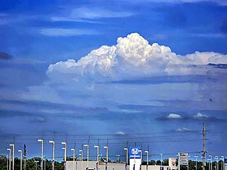
One of several supercells that produced large hail during the afternoon of May 5. This one has a stout updraft base just north of Odessa, Texas. The view is to the west. |
|
This is an annotated visible satellite just around 1330z on May 6 showing the synoptic environment over the target area. A complicated and messy convective scenario is evolving from central to eastern Texas. |
|
Base reflectivity image out of central Texas at roughly 4:30 PM CDT showing a storm cluster near Midland, Texas. |
|
View of gust front associated with the MCS passing by I-45 north of Willis, Texas on May 6. The view is to the southwest. |
|
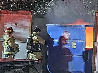
The period on and from May 7th through the 13th was down time, with little activity expected until after May 13. In this picture, firefighters are responding to a dumpster file in a Texas hotel parking lot. |
|
This is an annotated visible satellite just around 0z on May 15 (evening of May 14) showing the synoptic environment over the target area. Multiple boundaries and a moisture axis are providing support for storms, especially in SW Nebraska. |
|
Base reflectivity image out of SW Nebraska at roughly 7:00 PM CDT showing at least two supercell storms to the south and west of North Platte, Nebraska. A small tornado is being produced by the leftmost storm in the image. |
|
Close view of land-spout tornado / debris cloud on the ground to the southwest of Hershey, Nebraska during the early evening of May 14. |
|
May 16 was strictly a travel day with a long trip from Grand Island, Nebraska into Saint Louis, Missouri anticipating a major storm outbreak on May 17. I did not chase the high probabilities in MN / WI but caught this view of towering cumulonimbus clouds along the dryline - Which is rare this far east. The view is SE from northwest of Saint Louis. |
|
This is an annotated visible satellite at around 23z May 16 showing the synoptic environment over the target area. A potent upper level system is producing a powerful jet stream over a cold front interacting with a convergence area near extreme S IL and into KY. |
|
Base reflectivity image out of Peducah, Kentucky at roughly 3:00 PM CDT showing two tornado-warned supercell storms approaching from the west over SE Missouri. The southern storm would produce at least three tornadoes along a long track. |
|
View of a tornado with debris cloud on the ground to the west of Sikeston, Missouri during the late afternoon of May 16. |
|
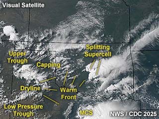
This is an annotated visible satellite at around 22z May 17 showing the synoptic environment over the target area. Another upper level system is approaching from the west, with a supercell (currently splitting in this image) south of OKC along the warm front. |

|
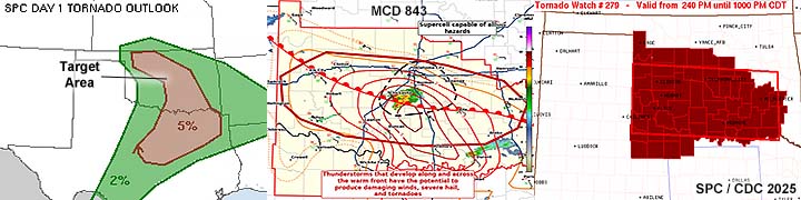
Base reflectivity image out of Oklahoma City at roughly 5:00 PM CDT showing a splitting supercell storm south of Oklahoma City, Oklahoma. The right split (bottom in image) would produce a brief tornado near Pauls Valley. |
|
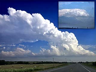
View of highly-sheared LP storm that tried to develop west of Clinton, Oklahoma during the afternoon of May 17. The view is to the south. The upper-right inset is a distant view of a tornado warned supercell to the SE near Pauls Valley. |
|
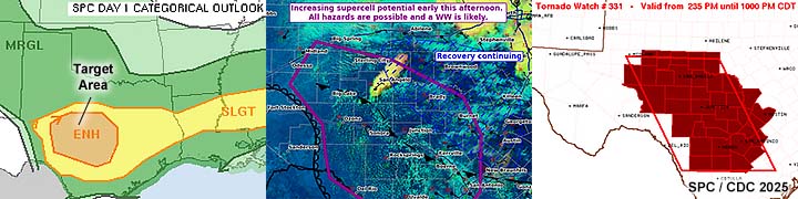
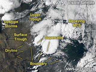
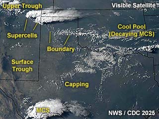
This is an annotated visible satellite at around 23z May 18 showing the synoptic environment over the target area. Tornadic supercells stretch from SW Nebraska through northwestern Oklahoma. |
|
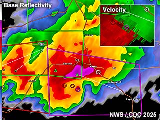
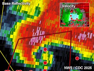
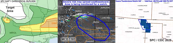
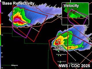
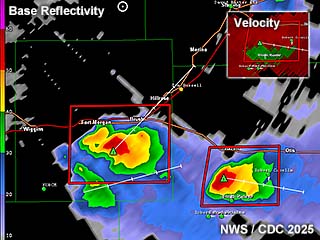
Base reflectivity image for west-central Oklahoma (Vance AFB radar) at roughly 5:30 PM CDT showing a tornadic supercell near Arnett, OK. The Doppler velocity is in the upper-right inset. This is about the time a powerful tornado was forming near Arnett. |
|
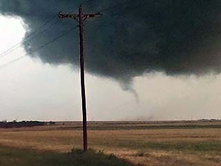
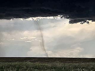
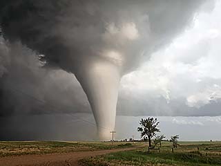
Incredible view of a strong tornado barely missing Arnett, Oklahoma during the early evening of May 18. Note the smashed windshield - Hail was larger than baseballs with this storm! The view is to the SE. |
|
This is an annotated visible satellite at around 22z May 19 showing the synoptic environment over the central USA. |
|
Base reflectivity image for near the Red River in Texas and south-central Oklahoma (Frederick radar) at roughly 4 PM CDT showing a tornado-warned supercell west of I-95. The Doppler velocity is in the upper-right inset. |

|
View of "whales mouth" on the back side of a powerful gust front (tornado warned storm) passing over Love County near the Red River late in the day on May 19. The view is to the south. |
|
May 20 and 21 was down time spent in Moore, Oklahoma. I was able to get the windshield changed out, and visited the Tim Samaras memorial in El Reno as well. |
|
This is an annotated visible satellite at around 0z May 23 (evening of May 22) showing the synoptic environment over Texas and surrounding areas. Note the long-track supercell moving southeast between Wichita Falls and Palo Pinto County. |
|
Base reflectivity image for near Palo Pinto County in Texas (Dyess AFB radar) at roughly 6 PM CDT showing a long-tracked supercell moving S and SE. The Doppler velocity is in the upper-right inset. |
|
View of powerful updraft of down-scaling supercell near Palo Pinto, Texas with incredible striations and structure during the evening of May 22. The view is to the north. |
|
May 23 was a down day dur to work requirements and not wanting to drive all the way to Colorado. This is a distant storm looking east from Stillwater late in the day on May 23. The view is to the east. |
|
This is an annotated visible satellite at around 1z May 25 (evening of May 24) showing the synoptic environment over Texas and surrounding areas. Supercells are struggling to develop over west-central Oklahoma. |
|
Base reflectivity image for western Oklahoma in Texas (Vance AFB radar) at roughly 9:30 PM CDT showing two supercells are struggling to develop. |
|
View of developing supercell between Elk City and Arnett, Oklahoma at dusk on May 24. The view is to the west. |
|
This is an annotated visible satellite at around 23z on May 25 showing the synoptic environment over west Texas and surrounding areas. |
|
Base reflectivity image (Dyess AFB radar) at roughly 7:30 PM CDT showing an HP supercell that produced a weak tornado. The Doppler velocity is in the upper-left inset. |
|
View of brief tornado to the west of Stamford, Texas during the evening of May 25. The view is to the northwest. |
|
This is an annotated visible satellite between 21 and 22z on May 26 showing the synoptic environment over west Texas and surrounding areas. A powerful supercell is intensifying southeast of San Angelo, Texas. |
|
Base reflectivity image (Dyess AFB radar) at roughly 5:30 PM CDT showing a powerful HP supercell between Mason, Texas. The Doppler velocity is in the upper-right inset. |
|
Possible developing tornado (lower right in photo) to the northwest of Menard, Texas before evolving from classic to HP supercell mode during the afternoon of May 26. The view is to the north. |

|
This is an annotated visible satellite at around 22z on May 27 showing the synoptic environment over Texas and surrounding areas. |

|
Base reflectivity image (Midland / Odessa radar) at just before 5 PM CDT showing small supercells forming in the up-slope regime southwest of Fort Stockton, Texas. |
|
View of hail up to 1" covering the roadway west of Marathon, Texas during the late afternoon of May 27. |
|
This is an annotated visible satellite around 0z on May 29 (evening of May 28) showing the synoptic environment over Colorado and surrounding areas. A supercell can be seen in eastern Colorado, but is elevated atop a warm front. |
|
Base reflectivity image (Goodland, Kansas radar) at roughly 5:30 PM CDT showing a supercell approaching Sheridan Lake, Colorado. The Doppler velocity is in the upper-right inset. |
|
Powerful area of rotation with a supercell storm south of Cheyenne Wells, Colorado during the afternoon of May 28. Funnel can be seen with blowing dust. The view is to the north and northwest. |
|
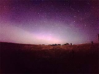
The period on and from May 29th through June 2nd was down time, with low-level activity expected. In this picture, I got a brief glimpse of an aurora (looking north) in north-central Nebraska after midnight on June 1 as a geomagnetic storm was winding down. |
|
This is an annotated visible satellite around 0z on June 2 (evening of June 1) showing the synoptic environment over the central high plains. The target area is in an up-slope wind regime near and south of the WY / CE / NE borders. |
|
Base reflectivity image (Denver, Colorado radar) just after 6:30 PM MDT showing a powerful supercell over Stoneham in NE Colorado. The Doppler velocity is in the upper-right inset. |
|
View of rapidly intensifying LP / classic supercell storm over Weld County, Colorado during the evening of June 2. The view is to the west. |
|
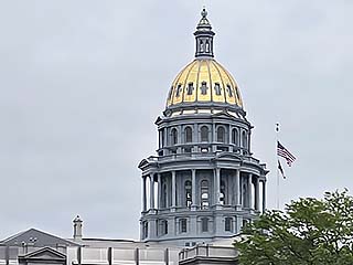
June 3 was an off day (did not want to travel way back down to southern OK overnight for marginal setup). I spent much of this time working full-time on projects for my remote IT job. This is a view of the Capitol Building in downtown Denver. |
|
This is an annotated visible satellite around 1z on June 5 (evening of June 4) showing the synoptic environment over Texas and New Mexico. The target area is in an up-slope wind regime near Santa Rosa, New Mexico and eastward into the TX Panhandle. |
|
Base reflectivity image (Amarillo, Texas radar) just before 9:30 PM CDT showing a powerful HP supercell / bow south of Adrian, Texas. The Doppler velocity is in the upper-right inset. |
|
View of brief tornado associated with an HP supercell evolving to a powerful bow segment after dark on June 4 near Adrian, Texas. The view is to the northwest. |
|
This is an annotated visible satellite around 22z on June 5 showing the synoptic environment over Texas and New Mexico. The target area (along warm front / boundary) is west of Lubbock and near the New Mexico border. |
|
Base reflectivity image (Lubbock, Texas radar) around 5:30 PM CDT showing a tornadic supercell near Morton, Texas with incredible TVS / debris ball presentation. The Doppler velocity is in the upper-right inset. |
|
View of powerful wedge tornado, under incredible storm structure and with red dust, with satellite tornado left of it, northwest of Morton, Texas during the afternoon of June 5. The view is to the northwest. |
|
This is an annotated visible satellite around 22z on June 6 showing the synoptic environment over Texas and New Mexico. The target area (along an outflow) is again from west of Lubbock and near the New Mexico border. |
|
Base reflectivity image (Lubbock, Texas radar) around 7:30 PM CDT showing a tornadic supercell near Whiteface, Texas with another tornadic / hook echo presentation. |
|
View of broad multi-vortex tornado, near Whiteface and northwest of Sundown, Texas during the afternoon of June 6. A sub vortex with dust on the ground can be seen to the far left. The view is to the northeast. |
|
This is an annotated visible satellite around 0z on June 8 (evening of June 7) showing the synoptic environment over Texas and New Mexico. The target area is in northeastern New Mexico with two supercells on-going there. |
|
Base reflectivity image (Lubbock, Texas radar) around 6:30 PM MDT (7:30 PM CDT) showing two supercells over Union County, New Mexico. The Doppler velocity (from the tornado-warned storm on the NW) is in the upper-right inset. |
|
Incredible view of an LP supercell over Union County in northeastern New Mexico during the early evening of June 7. The view is to the west. |
|
This is an annotated visible satellite around 23z on June 8 showing the synoptic environment over Texas. The target area was southeast of Amarillo and into NW Texas. The only major tornadoes would form far to the NW side of this setup (western OK panhandle and TX). |

|
Base reflectivity image (Frederick, OK radar) around 4:30 PM CDT showing a powerful supercell near Hall County, Texas. The Doppler velocity is in the upper-right inset. |
|
Incredible view of classic to HP supercell near Lakeview, Texas near the Red River during the early late afternoon of June 8. A possible brief tornado is barely visible below the center of the picture. The view is to the southwest. |

|
The period on and from June 9th to the 12th was down time, with not much storm activity expected. This is one of the "gaming" machines at a hotel in North Platte, Nebraska. |
|
This is an annotated visible satellite around 1z on June 14 (evening of June 13) showing the synoptic environment over the central and northern high plains. The target area is in an up-slope wind regime from SE to NE Wyoming. |
|
Base reflectivity image (Rapid City, South Dakota) just before 8 PM MDT showing two LP supercells north of Gillette, Wyoming. The subtle Doppler velocity is in the upper-left inset. |
|
View of LP supercell north of Gillette, Wyoming during the evening of June 13. The view is to the north. |
|
This is an annotated visible satellite around 0z on June 15 (evening of June 14) showing the synoptic environment over the central and northern high plains. Storms are blossoming from SE to NE Wyoming in up-slope wind flow. |

|
Base reflectivity image (Riverton, Wyoming) around 4:30 PM MDT showing an LP supercell nearing Campbell County, Wyoming. The subtle Doppler velocity is in the upper-right inset. |
|
View of wall cloud associated with an LP supercell southwest of Bill, Wyoming during the evening of June 14. The view is to the west. |
|
This is an annotated visible satellite around 0z on June 16 (evening of June 15) showing the synoptic environment over Wyoming, Colorado, and Nebraska. Obviously a very complex convective environment is underway, making forecasting such a setup nearly impossible. |
|
Base reflectivity image (Cheyenne, Wyoming) around 4:30 PM MDT showing a two high-based supercells near Morgan County, Colorado. The subtle Doppler velocity is in the upper-right inset. |
|
Not sure if this is a thin land-spout tornado or just an unusual rain shaft. You decide. This was near Brush, Colorado on the late afternoon of June 15. The view is to the west. |
|
View of intense rotation and mammatus associated with a high-based supercell storm within a bow segment northwest of Julesburg near sunset. The view is to the northwest. |
|
This is an annotated visible satellite around 1z on June 17 (evening of June 16) showing the synoptic environment over Colorado and Nebraska. A powerful tornadic supercell is on-going over west-central to SW Nebraska. |
|
Base reflectivity image (North Platte, Nebraska) just after 7:30 PM CDT showing a tornado-producing cyclic LP to classic supercell over Lincoln County, Nebraska. The strong Doppler velocity is in the upper-right inset. |
|
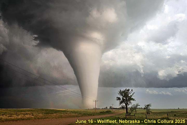
Large stove-pipe tornado fully planted south of SR 23 and west of Wellfleet during the late afternoon of June 16. The view is to the southeast. |
|
This is an annotated visible satellite around 1z on June 18 (evening of June 17) showing the synoptic environment over the Texas panhandles and surrounding areas. A powerful tornadic HP supercell is on-going over the northeastern Texas panhandle and into extreme west-central Oklahoma. |
|
Base reflectivity image (Vance AFB, Oklahoma) around 8 PM CDT showing a tornado-producing HP supercell near Higgins, Texas. The strong Doppler velocity is in the upper-right inset. |
|
Tornado becomes visible inside the "bear's cage" of an HP supercell south of Higgins, Texas during the early evening of June 17. Extreme winds and large hail were wrapping around this tornado. The view is to the northeast. |
|
This is an annotated visible satellite around 0z on June 19(evening of June 18) showing the synoptic environment over the Oklahoma target and surrounding areas. |
|
Base reflectivity image (Frederick, Oklahoma) around 6:15 PM CDT showing a supercell over Comanche County, Oklahoma. |
|
Supercell storm developing to the southeast of Lawton, Oklahoma during the late afternoon of June 18. The view is to the north. |
|
June 19th was a long re-position from Stillwater, Oklahoma to Sioux Falls, South Dakota with little storms expected. However, a tornado warned supercell looms west of me while in east-central Nebraska, with a horseshoe vortex also observed! |
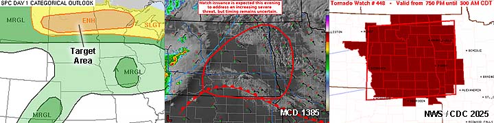
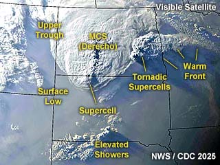
|
This is an annotated visible satellite around 2z on June 21 (evening of June 20) showing the synoptic environment over North Dakota and surrounding areas. Two powerful tornadic supercells are on-going ahead (east) of a derecho (MCS with straight-line winds). |
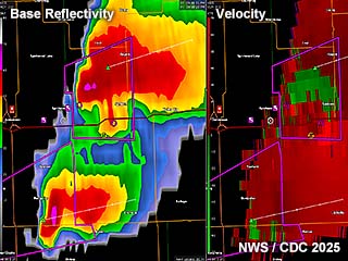
|
Base reflectivity image (Fargo, North Dakota) at just before 10 PM CDT showing two powerful tornadic supercells from Stutsman to Ransom Counties, North Dakota. Doppler velocities are in the right panel. |
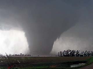
|
Large (possibly violent) tornado to the northwest of Spiritwood in Stutsman County, North Dakota during the early evening of June 18. The view is to the northwest. |
|
June 21st was an off day spent in Fargo, North Dakota for vehicle maintenance and attending mass during the afternoon. No storm chase prospects were present for this day. In this picture, I am enjoying a 22oz steak at their local steakhouse. |
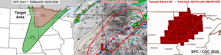
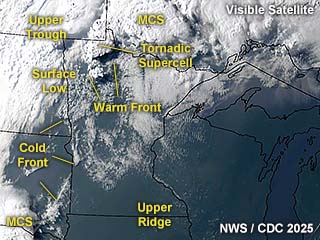
|
This is an annotated visible satellite around 0z on June 23 (evening of June 22) showing the synoptic environment over North Dakota and Minnesota. A tornado-producing supercell in far northwestern to northern Minnesota. |
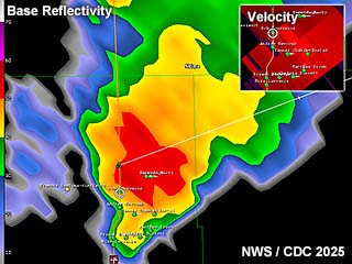
|
Base reflectivity image (Fargo, North Dakota) at around 7 PM CDT showing a tornadic supercell northwest of Grygla, Minnesota. Doppler velocities are in the upper-right inset. |
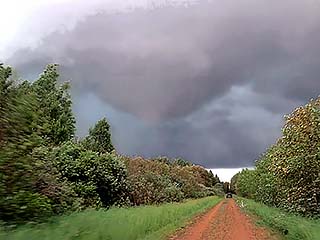
|
View of tornado through the trees in challenging chase terrain northwest of Grygla, Minnesota during the early evening of June 22. The view is to the east and northeast. |
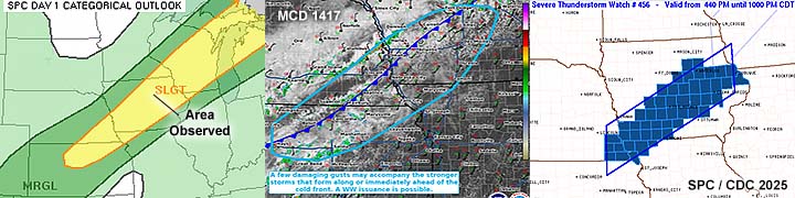
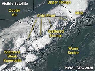
|
This is an annotated visible satellite around 21z on June 23 showing the synoptic environment over the American Midwest. This active pattern is due to a cold front and severe threat is not as high as previous days. |
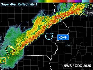
|
Base reflectivity image (Davenport, Iowa) at just before 8 PM CDT showing a squall line of strong thunderstorms crossing east-central to eastern Iowa. |
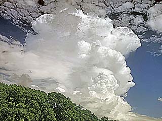
|
View of stout "popcorn" type shower / thunderstorm near Waterloo, Iowa during the afternoon of June 23. Note the storm is more "vertical" and not highly sheared as with previous storms - Denoting upper air support for severe weather is not coupled with the surface features anymore. The view is to the northeast. |
|
The period on and from June 24th to the 27th were strictly travel days. This is where I drove from Iowa / Illinois and eventually into South Florida. Here is the Florida state-line sign off I-75. |
HTML File "mwcl2025.htm" - Developed By Chris Collura

My Contact Information Is Given In The Graphic Above
To Prevent SPAM And Abuse - The EMAIL Banner Above Only Links To My Information Page
For My EMAIL - You Will Need To Take It Down And Enter It In Your EMAIL Package
To Return To The HOME Page Of This Site Click The "INDEX.HTM" Link Here!