
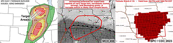
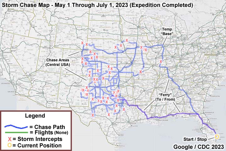
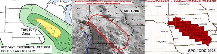
| This section is for storm chases done in the central / Midwestern United States during the year of 2023. This includes all storm chasing activities (including any major chase "expeditions") during the year of 2023 in the central USA (aka "Tornado Alley"). For 2023, all chases in the central USA will be logged in this section, with many of the chases being possible "spot" chases / major severe weather "setups" chased. Here you should find many pictures of lightning, tornadoes, hail, strong winds, along with many severe thunderstorm elements. Keep in mind that this chase log is scientific evidence and portrays my on-going storm chasing research. It has been placed on this page for easy reference and meteorological interests. Please do not plagiarize or copy this document to other sites for distribution. Note - This page may take a while to load on some SLOWER connections! |
STORM CHASING - CENTRAL UNITED STATES - 2023 CHASE LOG
| CHASER NAME | HOME / BASE CITY | CALLSIGN | CHASE DATES | OCCUPATION |
| CHRIS COLLURA | DEERFIELD BEACH, FL | KG4PJN | 4/3 TO 4/5 | IT CONSULTANT |
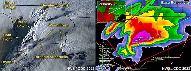
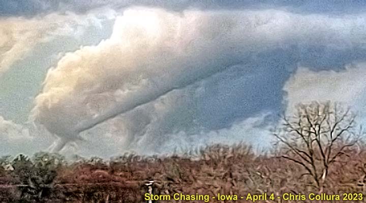
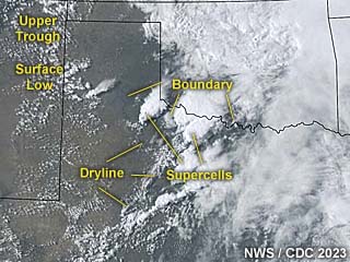
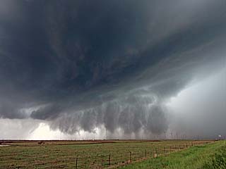
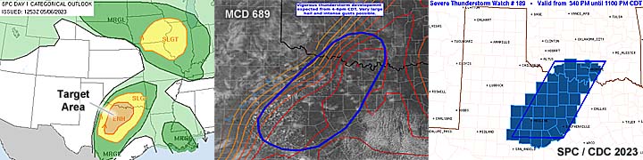
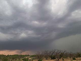
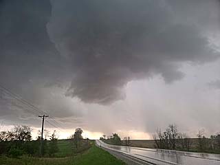
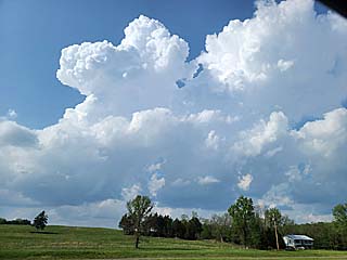
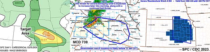
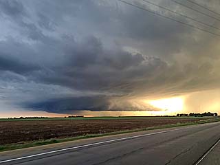
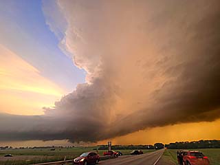
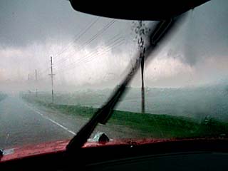
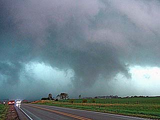
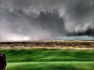
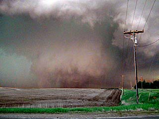
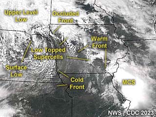
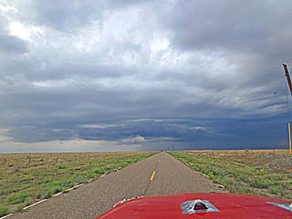
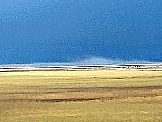
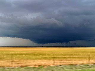
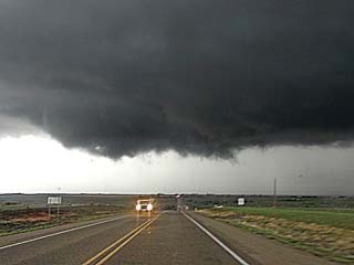
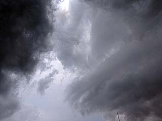
1). April 4, 7:00 PM - Interception and observation of an extremely severe (and tornadic) thunderstorm from Marion County near Knoxville / Pleasanton, Iowa and north and east towards Poweshiek County and along SR 92 / 12 and eventually towards SR 102 and Highway 63. The storm was a classic supercell storm, intercepted from the east long-range. A large elephant-trunk / rope tornado was encountered once close to the supercell storm, which listed rapidly northeast and dissipated near Lake Red Rock. A second, and larger possible tornado was also observed near Sully and Pella looking northeast after dark. The storm core was not penetrated, and hail hail up to 3". Rain, strong winds, and frequent lightning was observed with this storm as well. The storm had an impressive visual appearance, with RFD clear slot and striated updraft. Conditions causing the storm were surface heating, a low pressure area, warm front, and powerful upper-trough. Documentation was digital stills and HD video. A 2023 Hyundai Santa Fe was used to chase the storm. A tornado watch was in effect for the area until 10 PM CDT.
2). April 4, 9:00 PM - Indirect penetration of severe thunderstorms from east of Altoona, Iowa along I-80 in Polk County. These storms formed a line ahead of an advancing cold front well after dark, some with rotation (embedded supercells). Conditions encountered were 50 MPH winds, small hail, very heavy rains, and frequent lightning. Conditions causing the storm were a low pressure area, cold front, and upper-trough. A 2023 Hyundai Santa Fe was used to chase the storms. A tornado watch was in effect for the area until 10 PM CDT.
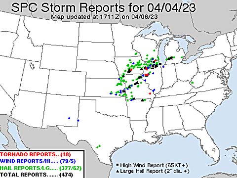
This concludes the chase log for a quick chase trip to the central United States and Midwest (mainly Iowa) for April 3 to 5, 2023. The summary includes a total of 2 observations, out of which was 2 severe thunderstorm. Out of these thunderstorms, 2 tornadoes were observed. The main chase vehicle conducting these chases was a 2023 Hyundai Santa Fe (rental). Total mileage was 892 miles. This information was prepared exclusively for the National Weather service and the team of Skywarn storm spotters.
|
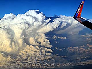
This is a view of severe thunderstorms from high altitude over Alabama on April 3, while flying from Fort Lauderdale, Florida to Kansas City, Missouri. Some of these storms produced tornadoes as well. |

|
View of Kansas City just before landing at MCI (Kansas City International Airport) during the evening of April 3. |
|
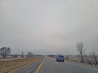
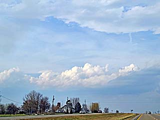
Starting the day out near Iowa City, Iowa with cool temperatures in the mid 50's and drizzle. This is north of the warm front on April 4. |
|
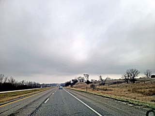
South of Iowa City and towards Mount Pleasant on I-380, the warm front boundary is reached, with clearing to the south and warming temperatures by afternoon. |
|
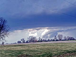
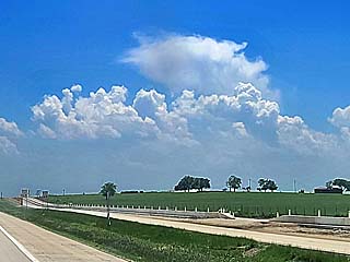
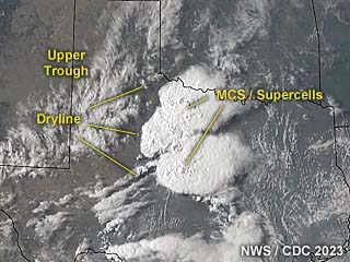
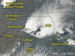
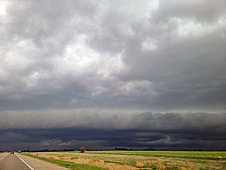
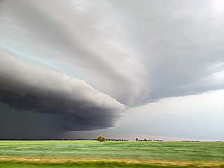
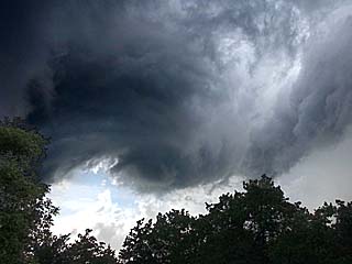
Looking north west of Mount Pleasant, and in warm temperatures in the upper 80's, the clouds along the warm front can be seen. Some storms are developing from this area, but racing eastward into Illinois. Not wanting to play "catch-up" with those storms, not to mention a time-consuming crossing of the Mississippi River, I opted to head west to the second target area south of Des Moines. |
|
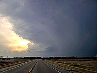
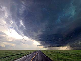
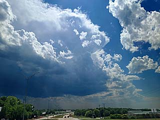
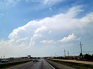
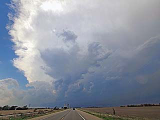
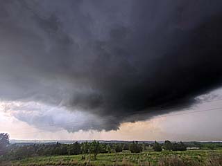
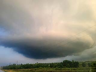
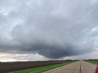
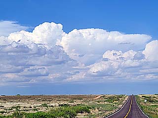
Looking west along SR 92 and headed towards Marion County, Iowa, a "tail-end" supercell can be seen looming over the horizon. This is the storm being targeted at roughly 6:30 PM CDT. The view is to the west near Sigourney, Iowa. Note the impressive anvil blow-off - This storm was along the "triple-point" and warm front near the surface low, and experienced nearly 200 MPH of bulk wind shear from the low levels to 10km altitude (east winds at 35 Kts near surface 925 mb and WSW at 150 Kts with jet stream at 250 mb level)! |
|
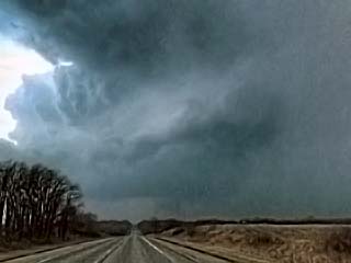
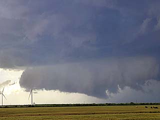
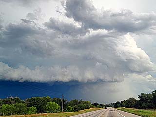
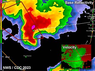
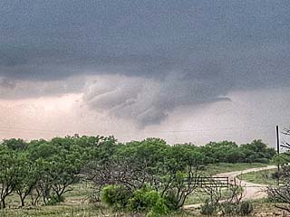
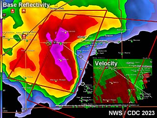
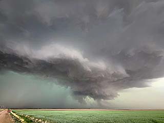
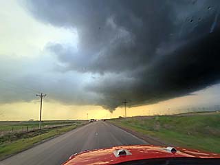
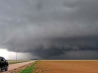
Closer in to the Marion County supercell, which is now tornado warned just before 7 PM CDT. The view is to the west, and a developing tornado (and wall cloud) under the storm can be seen in the lower portion of the picture, just right of the roadway. The hail core, with hail to 3", is to the right. |
|
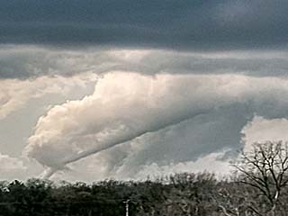
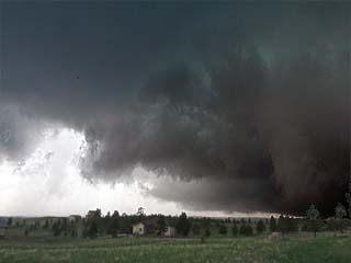
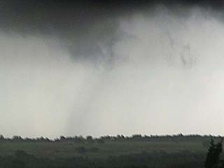
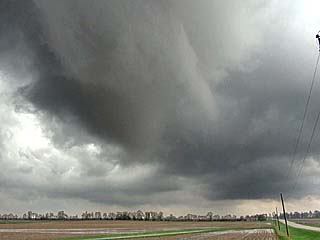
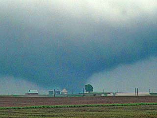
View of rope tornado looking WNW out of the Knoxville / Pleasanton area in Marion County, Iowa at roughly 7 PM CDT. |
|
Another closer view of the rope tornado. This was highly stretched in an environment of extreme wind shear and rather limited low-level moisture. The view is to the WNW. |
|
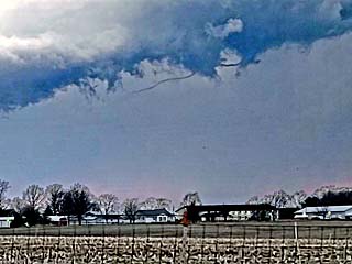
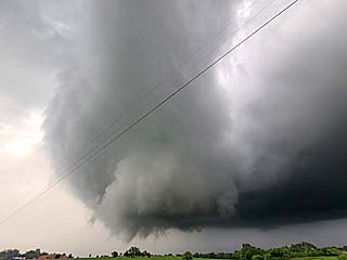
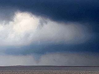
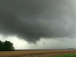
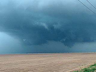
Tornado ropes out completely and dissipates as RFD (rear flank downdraft) occludes north of Pleasanton. The view is NW. |
|
Small funnel and occluded mesocyclone near Lake Red Rock. |
|
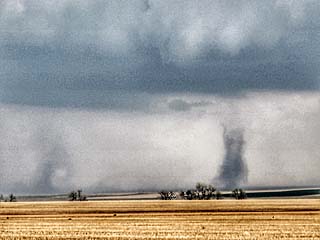
The storm quickly cycles up again, and produces another possible tornado (at least a rapidly developing wall cloud) near Sully, Iowa before 8 PM. The image has been brightened as it was getting dark, and the view is to the NE from near Pella, Iowa. This storm was moving NE at 50 to 60 MPH, so there was little chance of catching it at this point. |
|
Highly enhanced (after dark) view of a possible large tornado from near Sully, Iowa. This was another confirmed (wedge?) tornado, fortunately, over open country, but few chasers were on it. The view is to the NE, and I quickly lost sight of it after this and ended the chase. |
|
A typical farmstead in southern Iowa west of I-35 while driving from Des Moines to Kansas City on a clear day behind the cold front on April 5. |

|
A flag flies half-mast north of Kansas City honoring those lost in the USA the past month, including the previous tornado outbreaks. |
|
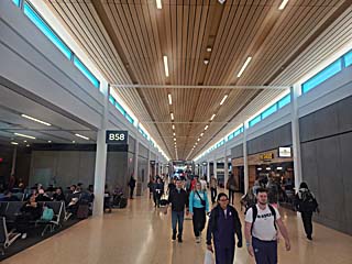
View of the new terminal building (while waiting to board my flight back to Florida) in Kansas City International airport (MCI) which just opened in March 2023. Travel to (and from) Florida was very busy (and expensive) due to Spring Break. |
| CHASER NAME | HOME / BASE CITY | CALLSIGN | CHASE DATES | OCCUPATION |
| CHRIS COLLURA | DEERFIELD BEACH, FL | KG4PJN | 5/1 TO 7/1 | IT CONSULTANT |
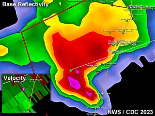
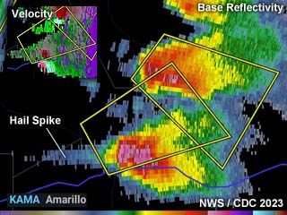
1). May 4, 4:00 PM - Interception and observation of a very severe thunderstorm to the southwest of Crowell, Texas in Foard County, and near SR 6 and south of Highway 70. The storm was a classic to HP supercell storm. This storm exhibited a striking visual appearance, with inflow bands and striations. A rotating wall cloud was also observed on the southwest side of this storm. The core was not directly penetrated, and contained baseball sized (or larger) hail. In addition to strong rotation on the storm, 50 MPH winds, frequent lightning, heavy rains, and hail up to 3/4" was encountered. Surface heating, a dryline / boundary interactions, a low pressure area, and upper trough caused the storm. Documentation was digital stills and HD video. A 2022 Jeep Renegade was used to chase the storm. A tornado watch was valid for the area until 9 PM CDT.
2). May 4, 6:30 PM - Interception and observation of a severe thunderstorm near Peducah, Texas in Cottle County, and near Highways 70 and 83. The storm was a LP to classic supercell storm. This storm also exhibited a striking visual appearance, with inflow bands and striations. A wall cloud was also observed on the southwest side of this storm. The core was not directly penetrated, and contained large hail. Conditions observed were 40 MPH winds, occasional lightning, and moderate rains. Surface heating, a dryline / boundary interactions, a low pressure area, and upper trough caused the storm. Documentation was digital stills and HD video. A 2022 Jeep Renegade was used to chase the storm. A tornado watch was valid for the area until 9 PM CDT.
3). May 5, 4:00 PM - Observation of a developing severe thunderstorm in Wise County, Texas near Bridgeport and Highway 380. The storm was an LP to classic supercell storm with a high base. The storm also was producing large hail. The core was not penetrated. Other conditions encountered were 40 MPH winds, light rain, and occasional lightning. Conditions causing the storm were surface heating (around 100 degrees F at the surface!), a stationary outflow boundary, and a weak upper trough. Documentation was digital stills. A 2022 Jeep Renegade was used to chase the storm. A severe thunderstorm watch was valid for the area until 10 PM CDT.
4). May 5, 5:30 PM - Observation and indirect penetration of a severe thunderstorm storm south of Comanche, Texas in Comanche County, and near SR 16. The storm was part of a multi-cell cluster of strong and severe storms, some containing large hail. The cores were not directly penetrated. Conditions encountered were heavy rains, lightning, 40 MPH winds, and hail up to 3/4". Conditions causing the storm were surface heating, a dryline, boundary interactions, and a weak upper trough. Documentation was digital stills. A 2022 Jeep Renegade was used to chase the storm. A severe thunderstorm watch was valid for the area until 10 PM CDT.
5). May 6, 6:00 PM - Interception and observation of a severe thunderstorm to the southwest of Throckmorton, Texas in Throckmorton County and west of Highway 183. The storm was a classic supercell storm, developing within a cluster of strong and severe thunderstorms, and exhibited rotation before being weakened and / or absorbed into the messy MCS. A rotating area, with RFD clear slot and brief funnel cloud, was observed on the southwest side of the storm. The storm quickly evolved to a multi-cell cluster thereafter. Conditions encountered were frequent lightning, heavy rains, hail to 1", and 60 MPH winds. Conditions causing the storm were surface heating, a dryline, boundary interactions, and an upper trough. Documentation was digital stills and HD video. A 2022 Jeep Renegade was used to chase the storm. A severe thunderstorm watch was valid for the area until 11 PM CDT.
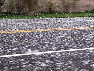
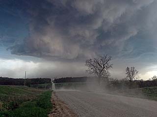
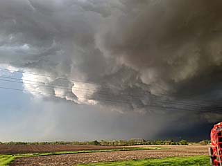
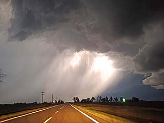
6). May 7, 4:30 PM - Interception and penetration of an extremely severe thunderstorm along I-80 through Grinnell, Iowa in much of Poweshiek County. The storm was a powerful HP supercell that evolved to a line segment. Conditions encountered were very heavy rains, lightning, and wind-driven hail up to baseball sized (driven by winds gusting near 70 MPH). Most hail was golf-ball sized to 2" otherwise. This storm caused extensive hail and wind damage. My vehicle had some dents from this storm, but the hail guards protected the windows. Conditions causing the storm were surface heating, a low pressure trough, boundary interactions, and an upper trough. Documentation was digital stills, audio, and HD video. A 2022 Jeep Renegade was used to chase the storm. A severe thunderstorm watch was valid for the area until 12 AM CDT the next day.
7). May 7, 5:30 PM - Interception and penetration of another extremely severe thunderstorm from near New Sharon and southeastward near Sigourney and east of Oskaloosa in Mashaka / Keokuk Counties, Iowa. This was near SR 92 and 78. The storm was a powerful HP supercell storm. An area of strong rotation, with a wall cloud and rain / hail wrap, was observed near What Cheer, Iowa. Conditions encountered were 60 MPH winds, heavy rains, frequent lightning, and thick quarter to golf ball-sized hail, with some isolated stones exceeding 2" in diameter. Wind and hail (tree) damage was also observed. Conditions causing the storm were surface heating, a low pressure trough, boundary interactions, and an upper trough. Documentation was digital stills, audio, and HD video. A 2022 Jeep Renegade was used to chase the storm. A severe thunderstorm watch was valid for the area until 12 AM CDT the next day.
8). May 8, 5:30 PM - Observation and indirect penetration of a severe thunderstorm near Camdenton in Camden County, Missouri near Highway 54 and SR 5. The storm was a classic to HP supercell storm, embedded in a line of strong and severe thunderstorms. An area of strong rotation was observed on the south side of the storm before outflow under-cut it. A rotating wall cloud with funnel(s) was encountered as well. The storm was indirectly penetrated, and heavy rains, lightning, small hail, and 50 MPH winds were encountered. Conditions causing the storm were surface heating, a stationary frontal boundary, and a departing upper trough. Documentation was digital stills. A 2022 Jeep Renegade was used to chase the storm. A severe thunderstorm watch was valid for the area until 11 PM CDT.
9). May 9, 6:00 PM - Interception and penetration of an extremely severe thunderstorm from near Big Bend, Kansas in Barton County, and southeastwards past Highway 50 and 281, and to near Turon, Kansas in Reno County. The storm was an outflow dominant HP supercell. This storm had an impressive visual appearance, with striated updraft, and multi-tiered RFD shelf cloud. A rotating wall cloud was observed with this storm near Stafford. Finally the storm core was penetrated in Turon, where golf ball hail, driven by winds near 75 MPH, frequent lightning, and violent, horizontal rains were observed. Isolated hail stones were up to 2". The hail left an accumulation on the ground of a couple of inches. Flash flooding and tree damage was also observed. Conditions causing the storm were surface heating, an outflow frontal boundary, warm front, dryline, and an upper trough. Documentation was digital stills, audio, and HD video. A 2022 Jeep Renegade was used to chase the storm. A severe thunderstorm watch was valid east of the area until 6 PM CDT.
10). May 9, 7:30 PM - Interception and observation of an extremely severe thunderstorm near Pratt, Kansas and northeast of the intersection of Highway 281 and SR 61. The storm was an HP supercell evolving to a powerful bow segment. This storm also had a striking visual presentation when viewed from the east during its supercell stage. The core of the storm was not directly penetrated. Frequent lightning, with numerous close hits, moderate rain, small hail, and 40 MPH winds were encountered with this outflow dominant storm. Hail was observed several inches deep accumulation in Pratt, Kansas behind the storm, with flash flooding in progress. Many trees had leaves shredded and stripped from the hail. Conditions causing the storm were surface heating, an outflow frontal boundary, warm front, dryline, and an upper trough. Documentation was digital stills, audio, and HD video. A 2022 Jeep Renegade was used to chase the storm.
11). May 9, 9:00 PM - Passage to the west part of a supercell core near Rush Center in Rush County along Highway 183. The storm was a weakening HP storm, and the western side of the storm was grazed heading northward. Conditions encountered were strong winds from the east, gusting near 50 MPH, moderate rain, frequent lightning, and hail to 1". Hail was observed covering portions of Highway 183, with an accident (car skidded off the road) near Rush Center. Conditions causing the storm were surface heating, warm front, low pressure trough, and an upper trough. Documentation was digital stills, and HD video. A 2022 Jeep Renegade was used to chase the storm.
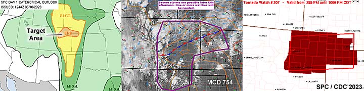
12). May 10, 4:00 PM - Interception of a very severe, and possibly tornadic thunderstorm in Douglas County, Colorado near The Pinery / Franktown and east of Castle Rock and along SR 86. The storm was an HP supercell storm. The storm was also tornado warned, and an area of rotation was observed on the southeast side of the area before the storm gusted out and evolved to a line segment. The core of the storm was not penetrated. Conditions encountered were 40 MPH winds, lightning, and light to moderate rain. Conditions causing the storms were modest surface heating, up-slope wind flow, a stationary frontal boundary, low pressure area, and an upper trough. Documentation was digital stills and HD video. A 2022 Jeep Renegade was used to chase the storm. A tornado watch was valid for the area until 9 PM MDT.
13). May 10, 6:00 PM - Observation and indirect penetration of a tornadic thunderstorm from north of Last Chance, Colorado and SR 71 in Washington County, and north and east into Akron along Highway 34. A landspout tornado was clearly observed during early stages of the storm looking northeast from north of Last Chance at a work-zone on SR 71. A second tornado was also produced by this storm, but I did not see it as the core was in the way. Other conditions encountered were small hail (observed covering Highway 34 west of Akron), frequent lightning, heavy rains, and 50 MPH winds. The core was not directly penetrated. Conditions causing the storms were modest surface heating, up-slope wind flow, a stationary frontal boundary, and an upper trough. Documentation was digital stills and HD video. A 2022 Jeep Renegade was used to chase the storm. A tornado watch was valid for the area until 9 PM MDT.
14). May 11, 7:00 PM - Observation and indirect penetration of a very severe and tornadic thunderstorm from east of Lawton, Oklahoma in Commanche County, Oklahoma near SR 7 and Sterling. The storm was a classic supercell storm, and was chased from Commanche County to Grady County. A small landspout type tornado was observed initial with this storm looking west as it was north of Sterling. Two other tornadoes, were also observed with this storm as it was near Highway 81 and Agawam. One was weak multi-vortex under a large rotating wall cloud, and another under a dramatic mesocyclone before being rain wrapped SW of Dibble. Little or no damage was observed. This was the same supercell that would produce additional small tornadoes, not observed, later on near Cole after dark. Other conditions encountered were 60 MPH winds, frequent lightning, heavy rains, and hail up to 1". Conditions causing the storms were surface heating, a dryline, and an upper trough. Documentation was digital stills and HD video. A 2022 Jeep Renegade was used to chase the storm. A tornado watch was valid for the area until 11 PM CDT.
15). May 11, 8:30 PM - Observation and indirect penetration of a very severe thunderstorm southeast of Chickasha and near Bradley in Grady County, Oklahoma near SR 19. The storm was an LP classic supercell storm. The storm had a striking visual appearance, with a barber-pole updraft and rotating wall cloud under it with occasional funnels. The core was not directly penetrated. Other conditions encountered were 40 MPH winds, frequent lightning, moderate rains, and small hail. Conditions causing the storms were surface heating, a dryline, and an upper trough. Documentation was digital stills and HD video. A 2022 Jeep Renegade was used to chase the storm. A tornado watch was valid for the area until 11 PM CDT.
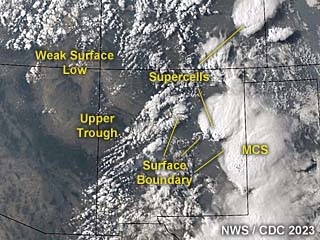
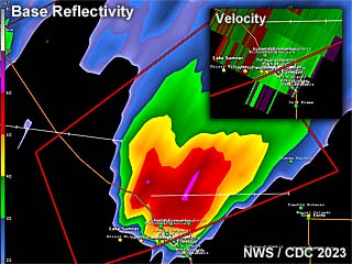
16). May 12, 5:30 PM - Observation and penetration of an extremely severe and tornadic thunderstorm in Platte County, Nebraska near Highway 81 and SR 91. The storm was an HP supercell, and was part of an arcing cluster of supercells stretching from near Genoa and eastward to near Humphrey. The storm produced a weak but wide tornado near Humphrey at around 5:15 PM CDT. The storm was HP and visibility was poor. Conditions encountered in the core of the storm were 1" hail, 60 to 70 MPH winds, torrential rains, and frequent lightning. Little or no damage was observed. Conditions causing the storms were surface heating, a dryline / occluded frontal system, low pressure area, and a powerful upper-level low (cold-core). Documentation was digital stills and HD video. A 2022 Jeep Renegade was used to chase the storm. A tornado watch was valid for the area until 9 PM CDT.
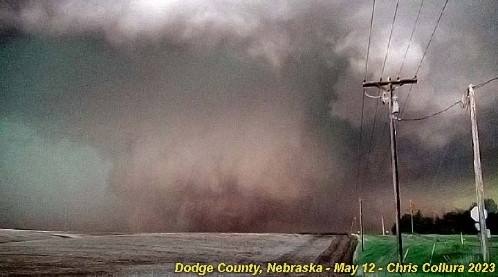
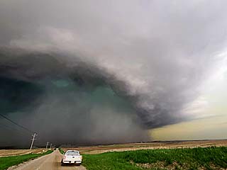
17). May 12, 6:00 PM - Observation and penetration of an extremely severe and potentially violent tornadic thunderstorm in Dodge County, Nebraska near Highways 275 and 77. The storm was an HP supercell, and was ahead of an arcing cluster of supercells stretching across northeastern Nebraska. The storm produced a potentially violent wedge tornado from east of Scribner and north to Uehling and Oakland near Humphrey at around 6 PM CDT. This wedge tornado quickly became rain-wrapped during a fairly close-range encounter looking south and then west, especially along County Road F. Major damage occurred west of Oakland and Uehling from this tornado, with 2 injuries. Other conditions encountered were heavy rains, 1" hail, near 70 MPH winds, and frequent lightning. Conditions causing the storms were surface heating, a dryline / occluded frontal system, low pressure area, and a powerful upper-level low (cold-core). Documentation was digital stills and HD video. A 2022 Jeep Renegade was used to chase the storm. A tornado watch was valid for the area until 9 PM CDT.
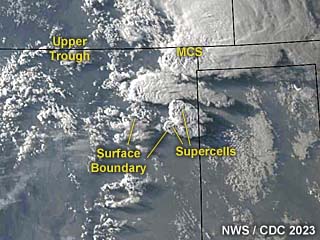
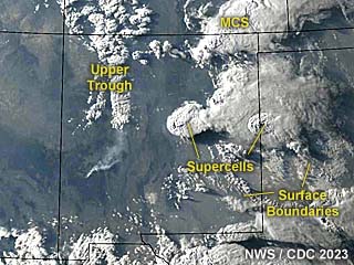
18). May 13, 4:00 PM - Observation and penetration of multiple strong to severe, and tornadic storms, training in an area near Storm Lake and Pocahontas, Iowa in Cherokee and Sac Counties, and north of Highway 20 and near Highway 71. These were multiple (like a dozen or so) classic mini-supercell storms, training from SE to NW in an arc - This will be logged as one intercept / observation for that matter. These small supercells exhibited strong rotation in the low-levels, with at least 5 or 6 weak tornadoes observed and documented. One weak tornado passed right over my location, with 60 to 70 MPH winds (EF-0 probably). Another tornado was observed at close-range crossing a field and barely missing a farmstead near Schaller. Another large, multi-vortex tornado, was observed looking north from SR 7 near Fonda (the low cloud base gave it a "wedge" appearance at one point)! These tornadoes mainly missed any structures and / or were in open fields. In addition to the multiple tornadoes, the store cores had 50 MPH winds, torrential rains, and small hail at best. Little or no lightning was observed with these low-topped mini supercells. Documentation was digital stills and HD video. Conditions causing the storms were surface heating, a low pressure area, an occluded warm front, and a weakening upper-low (cold-core). A 2022 Jeep Renegade was used to chase the storm. A tornado watch was valid for the area until 9 PM CDT.
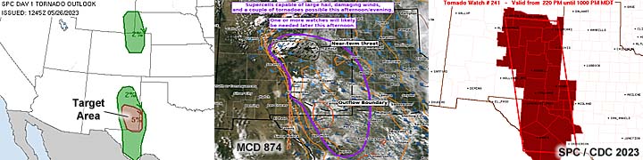
19). May 25, 9:00 PM - Interception and observation of a very severe thunderstorm between Tucamcari and Bard, New Mexico along I-40 in Quay County and west of the TX / NM border. The storm was a classic supercell storm, and was observed mainly from Bard just off I-40. The core was not penetrated, but light to moderate rain, inflow winds to 40 MPH, small hail, and continuous lightning. This storm was extremely active electrically, with very frequent lightning, as well as having a striking visual appearance, with a striated updraft with wall cloud under it. The storm contained hail at least 1" to 2". Conditions causing the storms were surface heating, up-slope wind flow, a low pressure trough, and an upper trough to the west. Documentation was digital stills and HD video. A 2022 Jeep Renegade was used to chase the storm. A severe thunderstorm watch was valid for the area until 2 AM MDT (3 AM CDT) the next day.
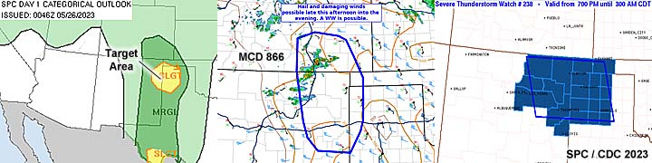
20). May 26, 8:00 PM - Interception and observation of a very severe thunderstorm northwest of Clovis, New Mexico in Curry County, north of Highway 60, and near SR 18. The storm was a classic to HP supercell storm. Strong rotation was noted with this storm north of Clovis with a rapidly rotating wall cloud, RFD clear slot, striated updraft, and several funnels. This was a possible very brief tornado but I was not able to confirm ground contact. The core of the storm was not directly penetrated. Conditions encountered were moderate rain, 50 MPH winds, small hail, and occasional lightning. Hail fog was noted north of the chase path and flash flooding was also observed with this storm. Conditions causing the storms were surface heating, up-slope wind flow, a low pressure trough, boundary interactions, and an upper trough. Documentation was digital stills, audio, and HD video. A 2022 Jeep Renegade was used to chase the storm. A tornado watch was valid for the area until 10 PM MDT.
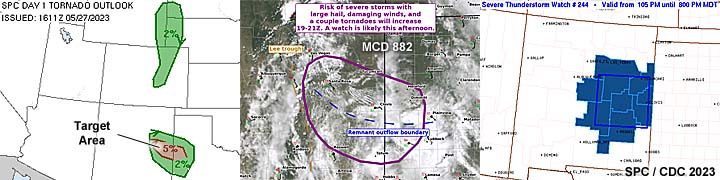
21). May 27, 5:00 PM - Interception and observation of severe thunderstorms in Roosevelt County in New Mexico, near CR 330 and 267. This was a bowing cluster of strong and severe storms, and was not penetrated, as interest turned towards more discrete supercells back to the northwest. The core(s) were not penetrated, but probably contained at least 60 MPH winds and hail exceeding 1". A brief funnel / lowering was noted with an area of rotation looking SW towards and intense cell in the north part of the bowing MCS. Conditions causing the storms were surface heating, up-slope wind flow, a low pressure trough, boundary interactions, and an upper trough. Documentation was digital stills. A 2022 Jeep Renegade was used to chase the storm. A severe thunderstorm watch was valid for the area until 8 PM MDT.
22). May 27, 6:30 PM - Interception and observation of an extremely severe, and tornadic thunderstorm in DeBaca County, New Mexico, from near Lake Sumner and Highway 84, and westward to south of House near SR 252. The storm was a powerful classic and cyclic supercell storm, slowly moving east, then ESE well north of Highway 60 and Fort Sumner. This supercell had an absolutely incredible visual presentation. The storm had a well-pronounced RFD, striated / multi-tiered updraft with inflow bands, and rapidly rotating wall clouds. A large funnel, with possible tornadic ground contact, was noted with this storm to the southwest of House, New Mexico. The storm core, which probably had giant hail, was not penetrated. Other conditions observed were winds near 50 MPH (mainly inflow), frequent lightning, and light rain. Conditions causing the storms were surface heating, up-slope wind flow, a low pressure trough, boundary interactions, and an upper trough. Documentation was digital stills and HD video. A 2022 Jeep Renegade was used to chase the storm. A severe thunderstorm watch was valid for the area until 8 PM MDT.
23). May 27, 8:00 PM - Interception and observation of a very severe thunderstorm in DeBaca County, New Mexico, also near Lake Sumner and Highway 84. The storm was another LP to classic supercell storm. This supercell had an impressive visual presentation, with wall cloud and RFD, albeit higher based. The storm core was not penetrated, with conditions encountered being winds near 30 MPH, occasional lightning, and light rain. Conditions causing the storms were surface heating, up-slope wind flow, a low pressure trough, boundary interactions, and an upper trough. Documentation was digital stills and HD video (with time-lapse). A 2022 Jeep Renegade was used to chase the storm. A severe thunderstorm watch was valid for the area until 8 PM MDT.
24). May 28, 3:00 PM - Interception and indirect penetration of a very severe and possibly tornadic thunderstorm in Beaver County, Oklahoma, north of Highway 412 and east of Highway 83 near Turpin and Balko. The storm was a classic supercell storm. A strong area of rotation was noted on the rear-flank of the storm, with rapidly rotating wall clouds, and funnels observed. The storm core was not directly penetrated, but hail to 1", 60 MPH winds, occasional lightning, and moderate to heavy rain was encountered near the core of the storm southeast of Turpin. The storm evolved to HP and weakened via down-scaling after that. Conditions causing the storms were surface heating, a weak low pressure trough, boundary interactions, and a negligible upper trough. Documentation was digital stills and HD video (with time-lapse). A 2022 Jeep Renegade was used to chase the storm.
25). May 28, 7:00 PM - Interception and observation of an extremely severe and tornadic thunderstorm in Sherman County, Texas, southeast of Stratford and near FM 1573 and 119. The storm was a classic to HP cyclic supercell storm. One interesting aspect of this storm was that it was a left-split, with the right-split completely dissipating. This highly deviant left-split moved to the northwest, and produced multiple (at least 4) tornadoes, one a large stove-pipe / elephant trunk, another a rope, and even multi-vortex. This storm had a very impressive visual appearance as well, with incredible inflow / rotor feeding into it (stream-wise vorticity current), RFD cut, and striated "multi-tiered" updraft. The storm core was not penetrated, but isolated 1" hail was noted falling out of the storm anvil south of the storm. Larger hail from the right-split was observed along the side of the road, from golf-ball sized to 2". Other conditions observed were 60 MPH inflow winds and frequent lightning. The storm merged with a powerful MCS, which had 60 to 70 MPH winds, torrential rains, and marble sized hail southeast of Statford along Highway 287. No major damage was observed, as these storms occurred over rural areas. Conditions causing the storms were surface heating, a weak low pressure trough, boundary interactions, and a negligible upper trough. Documentation was digital stills and HD video (with time-lapse). A 2022 Jeep Renegade was used to chase the storm.
26). May 29, 6:00 PM - Observation and indirect penetration of a severe thunderstorm in Chase County, Nebraska near Highway 6 and SR 61 southeast of Imperial. This storm was an LP supercell, which evolved to classic mode before down-scaling later. The storm was observed from initiation to weakening. For a while it had an impressive visual appearance (such as a bell-shaped updraft base and striations). The core was not directly penetrated, and small hail, lightning, light rain, and 30 MPH winds were encountered, particularly in Imperial, Nebraska. Conditions causing the storms were surface heating, a low pressure trough, convergence area, and a weak upper trough. Documentation was digital stills and HD video (including time-lapse). A 2022 Jeep Renegade was used to chase the storm. A severe thunderstorm watch was valid for the area until 10 PM CDT.
27). May 29, 7:00 PM - Observation of strong to severe thunderstorms in Phillips County, Colorado, along Highway 6 between Holyoke and Lamar, Nebraska. This storm was part of a multi-cell complex of strong and severe thunderstorms, and was outflow dominated. A nice shelf cloud and powerful gust front was also noted, with 2 gustnadoes (one a possible weak land spout) observed on the south side of the southern storm. The core(s) were not penetrated. Light rain, frequent lightning, and winds gusting near 50 MPH were encountered (mainly outflow). Conditions causing the storms were surface heating, a low pressure trough, convergence area, and a weak upper trough. Documentation was digital stills and HD video (including time-lapse). A 2022 Jeep Renegade was used to chase the storm. A severe thunderstorm watch was valid for the area until 10 PM CDT (9 PM MDT).
28). May 30, 6:00 PM - Observation and indirect penetration of strong and severe thunderstorms from near Sharon Springs in Wallace County, Kansas and southward along SR 27 towards Tribune and Syracuse into Hamilton County near Highway 50 and eventually Highway 160 near Ulysses. The storms were associated with a large multi-cell cluster of severe storms. Conditions encountered were heavy rains, small hail, 60 to 70 MPH outflow winds, and frequent lightning. Blowing dust was also noted with these storms. A well-developed shelf cloud and gust front developed late in the period from these storms, allow for an incredible view east of the storm complex in SW Kansas. Conditions causing the storms were surface heating, a weak low pressure trough, and dryline / surface boundary interactions. Documentation was digital stills and HD video (mostly time-lapse). A 2022 Jeep Renegade was used to chase the storm. A severe thunderstorm watch was valid for the area until 11 PM CDT.
29). May 30, 5:30 PM - Interception and observation of a very severe and possibly tornadic thunderstorm west of Dora and east of Elida in Roosevelt County, New Mexico and south along SR 206 to west of Minesland. The storm was a classic to HP supercell storm that evolved to a multi-cell cluster of severe storms. The storm produced a brief tornado south of Elida, but bad visibility (rain wrapping and dust) prevented observation. A brief funnel was observed with the storm west of Minesland before the storm weakened and became outflow dominant. A rotating wall cloud and RFD region was observed with this storm, The core was not penetrated. Other conditions observed were light rain, 40 MPH winds, and lightning. Conditions causing the storms were surface heating, a low pressure trough, dryline / surface boundary interactions, and an upper trough. Documentation was digital stills and HD video. A 2022 Jeep Renegade was used to chase the storm. A severe thunderstorm watch was valid for the area until 9 PM MDT.
30). May 30, 7:30 PM - Interception and penetration of a severe thunderstorm northeast of Plains, Texas in Yoakum County north of Highway 380 and near SR 214. The storm was a classic supercell storm, but was elevated as it was undercut by the cool pool from previous storms. The storm had a rain-free base with RFD cut, and hail core for some time. Conditions observed were frequent lightning, 40 MPH winds, and hail to 1". Conditions causing the storms were surface heating, a low pressure trough, surface boundary interactions, and an upper trough. Documentation was digital stills and HD video. A 2022 Jeep Renegade was used to chase the storm. A severe thunderstorm watch was valid for the area until 10 PM CDT.
31). June 1, 5:30 PM - Observation and penetration of a severe thunderstorm southeast of Lamesa, Texas in Dawson County and east of Highway 87. The storm was an LP supercell, that started out surface based and later became elevated. The core was penetrated during its early stages to get into position for another storm east. Hail up to 1" was observed, with 40 MPH winds, light rain, and occasional lightning. Conditions causing the storms were surface heating, a low pressure trough, surface boundary interactions, and an upper trough. Documentation was digital stills and time-lapse HD video. A 2022 Jeep Renegade was used to chase the storm. A severe thunderstorm watch was valid for the area until 10 PM CDT.
32). June 1, 5:30 PM - Interception and indirect penetration of a very severe thunderstorm southwest of Snyder, Texas near Ira and SR 350 in Bordon and Scurry Counties. The storm was an HP supercell storm, but was outflow dominant for most of the time. The storm core was not directly penetrated, but 60 MPH winds, small hail, lightning, and heavy rain was encountered. The outflow winds kicked up a lot of dust. A possible, brief land-spout tornado was barely visible when approaching the storm from the west (probably near Ira). Conditions causing the storms were surface heating, a low pressure trough, surface boundary interactions, and an upper trough. Documentation was digital stills. A 2022 Jeep Renegade was used to chase the storm. A severe thunderstorm watch was valid for the area until 10 PM CDT.
33). June 2, 5:30 PM - Interception, observation, and indirect penetration of an extremely severe and cyclic tornadic thunderstorm in Pecos County, Texas, from east of Fort Stockton and I-10 / FM-2886 south of Bakersfield and eastward to south of Sheffield. The storm was a classic to HP supercell storm, and produced at least 3 tornadoes, one a significant one near Fort Stockton and I-10. The storm formed in the early afternoon, and I was not able to see the Fort Stockton tornado as I was between it and the hail core at the time (heading south). The storm cycled back up, and a broad, but weak, multi-vortex tornado was observed west of FM-2886 in Pecos County south of Bakersfield. This quickly became rain wrapped on top of me, as I was in the supercell HP notch (aka "bear's cage"). The storm continued east, and acquired strong rotation and another couplet southwest of Sheffield. At this time, albeit poor contrast, a hint of a large tornado was noted looking north. The main core of the storm was not penetrated. Conditions observed were winds over 60 MPH, torrential rains, frequent lightning with some close hits, and hail up to 3" (noted on the side of the road), with golf-ball sized hail falling southwest of Sheffield. No damage was observed as the storm was mainly over rural areas. The storm caused flash flooding as well. Conditions causing the storms were surface heating, a low pressure trough, a dryline, outflow boundary, and an upper trough. Documentation was HD video and digital stills. A 2022 Jeep Renegade was used to chase the storm. A tornado watch was valid for the area until 8 PM CDT.
34). June 10, 4 PM - Observation and indirect penetration of a very severe thunderstorm in Navarro County, Texas and near I-45, from Ennis to Rice. The storm was an outflow dominant HP supercell storm that evolved to a multi-cell cluster of strong and severe storms. Strong rotation was noted with this storm, with a wall cloud, but was undercut by outflow and became rain wrapped. Strong winds over 60 MPH, torrential rains, hail to 1", and frequent lightning with close hits. The main core contained hail to tennis ball sized. Some tree damage and flash flooding was also noted with this storm. Conditions causing the storms were surface heating, a low pressure trough, surface boundary interactions, and an upper trough. Documentation was digital stills and HD video (including time-lapse). A 2022 Jeep Renegade was used to chase the storm. A severe thunderstorm watch was valid for the area until 10 PM CDT.
35). June 10, 6:30 PM - Interception and observation of a severe thunderstorm in Somervell and Hood Counties, Texas and near Highway 67, and near Glen Rose. The storm was a classic supercell storm. The storm had a wall cloud and rotation but weakened as other storms to its southeast stabilized its inflow layer. The main core was not penetrated. Conditions encountered were 40 MPH winds, small hail, occasional lightning, and moderate rain. Conditions causing the storms were surface heating, a low pressure trough, dryline (heat axis), surface boundary interactions, and an upper trough. Documentation was digital stills. A 2022 Jeep Renegade was used to chase the storm. A severe thunderstorm watch was valid for the area until 10 PM CDT.
36). June 11, 6:00 PM - Interception and observation of an extremely severe thunderstorm from Las Animas County, Colorado and later into Cimarron County, Oklahoma, from near Highway 160 near Kim, Colorado, and later northwest of Boise City, Oklahoma near SR 325 and points eastward to along Highway 412. The storm was a powerful HP supercell storm, forming over the higher terrain, and moving to the southeast. The storm had a very striking visual appearance with large wall cloud, RFD, striations, and hail core. The core was not directly penetrated until later in its life-cycle and when it weakened. The core had hail to at least 3". Conditions encountered were 60 MPH winds, torrential rains, hail to 1", and frequent lightning with some close hits. The storm produced incredible cloud-to-cloud lightning after dark. The storm produced a rotating wall cloud at some points in its life-cycle as well. Conditions causing the storms were surface heating, a low pressure trough, post-frontal up-slope, and an upper trough. Documentation was digital stills and HD video (including time-lapse). A 2022 Jeep Renegade was used to chase the storm. A severe thunderstorm watch was valid for the area until 9 PM MDT (10 PM CDT).
37). June 12, 7:00 PM - Observation and indirect penetration of an extremely severe thunderstorm from near Concho County, Texas to the northwest of Brady and near Highway 87 south to Mason. The storm was a powerful classic supercell storm, that explosively developed late in the day near a dryline and frontal boundary intersection. The storm had a very impressive visual appearance, with RFD, wall cloud, inflow bands, and "barber-pole" updraft during its weakening stages near Mason. A possible weak ground circulation was noted northwest of Brady under a rapidly rotating cloud base. The main core, with at least baseball sized hail, was not penetrated. Other conditions observed were heavy rains, 60 MPH winds, hail to 1", and frequent lightning with numerous close hits. The storm remained mainly over rural areas. Conditions causing the storms were surface heating, a low pressure trough, dryline / boundary interactions, and an upper trough. Documentation was digital stills, audio, and HD video (including time-lapse). A 2022 Jeep Renegade was used to chase the storm. A tornado watch was valid for the area until 10 PM CDT.
38). June 13, 6:00 PM - Interception, observation, and penetration of an extremely severe and tornadic thunderstorm from near Cimarron County, Oklahoma and Highway 287 / Ranch 807 (near Kerrick, Texas) and eastward along a long path through Sunray, Borger, and Pampa, and eventually to I-40 near Shamrock, Texas. The storm was a powerful HP supercell storm, and presented an impressive visual appearance at times. A weak tornado was observed in Dallam County looking west of Ranch 807. This was the second tornado (I missed another brief tornado near Felt farther northwest that became rain-wrapped). This storm had hail to grapefruit sized. The storm core was encountered near Pampa, with 2" (wind-driven) hail, lightning, torrential rains, and winds gusting over 70 MPH. Some damage and flooding was observed in this area. This storm had a long-track swath, from NW to SE, of over 200 miles! Conditions causing the storms were surface heating, a low pressure trough, post-frontal up-slope, and an upper trough. Documentation was digital stills, audio, and HD video. A 2022 Jeep Renegade was used to chase the storm. A severe thunderstorm watch was valid for the area until 9 PM CDT.
39). June 15, 6:00 PM - Observation and indirect penetration of an extremely severe and tornadic thunderstorm on a long path from near Hobart, Oklahoma in Kiowa County, and points southeast passing Cache, Comanche, and Loco in Stephens County, mainly near Highway 81 and SR 52, and eventually across the Red River and as far as Cook County and Gainesville, Texas near I-40 and Highway 82. This storm was a powerful cyclic HP supercell. During its life-cycle, it produced several tornadoes, mainly rain-wrapped. A large wedge tornado was observed, albeit low-contrast, looking west from near Loco and towards Comanche. While passing through Comanche, flying debris was noted, power out, and a large metal roof flew through the air and landed at the intersection of SR 52 and Highway 81. Two other weaker tornadoes were also observed. This storm also had two areas of rotation at one point, before a cell merger took place later in its life-cycle. Earlier the storm produced RFD winds exceeding 60 MPH, especially in Kiowa County and west of Cache. The core was not directly penetrated, but hail just under 2" was noted (the main core had wind-driven hail exceeding 3"). This cracked the windshield west of Hobart. The storm caused damage from near Duncan to Loco, and later more damage was noted in Gainesville, Texas near dusk. Frequent lightning (with some close hits), heavy rains, and winds over 70 MPH were also encountered. Conditions causing the storms were surface heating, a low pressure trough, stationary frontal boundary, dryline, and an upper trough. Documentation was digital stills, audio, and HD video. A 2022 Jeep Renegade was used to chase the storm. A tornado watch was valid for the area until 10 PM CDT.
40). June 15, 9:00 PM - Interception and observation of a very severe and formerly tornadic thunderstorm near Highway 82 and SR 59 in Montague County, Texas and southwest of Saint Jo. This storm was a classic to HP supercell storm that produced a brief tornado earlier. The storm was noted with frequent lightning, a wall cloud, and RFD cut when it was observed just after dark. The core was not directly penetrated, but 50 MPH winds, small hail, and heavy rains was encountered. Conditions causing the storms were surface heating, a low pressure trough, stationary frontal boundary, dryline, and an upper trough. Documentation was digital stills. A 2022 Jeep Renegade was used to chase the storm. A tornado watch was valid for the area until 10 PM CDT.
41). June 16, 6:00 PM - Interception and observation of a very severe thunderstorm from near Otero County, Colorado and SR 101 near Las Animas and southeastward past Prichett in Baca County along Highway 160 and east to Springfield. The storm started as a classic supercell storm, with a high base and large hail (exceeding 2"). It was tornado-warned for strong rotation, but only a rotating wall cloud was observed from time to time. An MCS to the west caught up with this supercell, and the storm back-built southward to the northwest of Prichett, where it evolved to LP mode. At this point, the storm acquired an impressive structural appearance, with a barber-pole / "stacked plates" mother-ship appearance, especially at it approached Springfield. A rotating wall cloud with brief funnel was noted there after dusk. The storm also was producing continuous lightning at this point. The core of the storm was not penetrated. Conditions encountered were light rain, 40 MPH winds, frequent lightning with close hits, and small hail. Conditions causing the storms were surface heating, a low pressure (lee) trough, up-slope wind flow, and an upper trough. Documentation was digital stills and HD video (including time-lapse). A 2022 Jeep Renegade was used to chase the storm. A severe thunderstorm watch was valid for the area until 9 PM MDT (10 PM CDT).
42). June 17, 6:00 PM - Observation and indirect penetration of an extremely severe and cyclic tornadic thunderstorm from near Turpin, Oklahoma and Highway 83 in Beaver County, and eastward near and north of Highways 412 and 270 into Harper County near May and Fort Supply. The storm started as a classic supercell, then evolved to HP mode, eventually growing up-scale as a powerful MCS overtook it around dusk. Two tornadoes were observed with this storm, one a dust swirl beneath a funnel on the wall cloud south of Turpin, and another larger, multi-vortex type weak tornado with occasional ground contact south of Beaver. The latter had very fast-moving cloud motion at cloud base, with a large, blocky and striated wall cloud. The core of the storm was not directly penetrated, but hail stones at least 3" were noted across the road between Beaver and Turpin on a country (EW 12) road. Other conditions encountered were 70+ MPH winds, especially in RFD and rear-inflow, heavy rains, and frequent lightning. The storm remained mainly over rural areas of Beaver and Harper counties. Conditions causing the storms were surface heating, a low pressure area, dryline, surface boundary interactions, and an upper trough. Documentation was digital stills and HD video (including time-lapse). A 2022 Jeep Renegade was used to chase the storm. A tornado watch was valid for the area until 11 PM CDT.
43). June 21, 3:00 PM - Interception and indirect penetration of a very severe and tornadic thunderstorm north of Sterling, Colorado in Logan County and near CR 46 and Highway 138. The storm was a classic supercell storm, and was part of a cluster of supercells that produced significant tornadoes later on south near Akron. When this storm was encountered, it rapidly developed and had a rotating wall cloud and RFD cut, along with a striated updraft base. A brief (but weak) tornado was observed with this storm, before it appeared to become outflow dominant and weaken. Other conditions observed were 40 to 50 MPH inflow winds, moderate rain, occasional lightning, and hail to 1". The biggest mistake, probably in my entire chasing career, was continuing off to the west, leaving this complex of storms, for the main (original) target area near SE Wyoming. Conditions causing the storms were surface heating, a low pressure trough, up-slope wind flow, surface boundary interactions, and an upper trough. Documentation was digital stills and HD video. A 2022 Jeep Renegade was used to chase the storm. A tornado watch was valid for the area until 8 PM MDT.
44). June 21, 5:30 PM - Interception and observation of a severe and possibly a former tornadic thunderstorm north of Chugwater, Wyoming in Platte County and along I-25. The storm was a supercell storm that evolved to a multi-cell cluster of severe storms. The storm had some rotation and inflow banding, but became outflow dominant and weakened, with an impressive shelf cloud observed north of Chugwater. The store core was not penetrated. Occasional lightning was observed. The demise of this storm drove home the point to NEVER leave a storm (the one earlier near Sterling, Colorado) until its completely "done". Conditions causing the storms were surface heating, a low pressure trough, post-frontal up-slope wind flow, surface boundary interactions, and an upper trough. Documentation was digital stills and HD video. A 2022 Jeep Renegade was used to chase the storm. A tornado watch was valid for the area until 8 PM MDT.
45). June 22, 3:30 PM - Interception and penetration of an extremely severe and tornadic thunderstorm south of Littleton, Colorado and near Highlands Ranch in Arapahoe County and near Highway 470. The storm was a powerful classic to HP supercell storm, that evolved to an intense bow segment afterwards. This storm produced a large rain-wrapped tornado that tracked southeastwards from Littleton, past Lone Tree, and to Highlands Ranch. This tornado was observed at very close range, with inflow jets and winds gusting over 100 MPH feeding into it from the left side with low, fast moving clouds. Hail up to 2" was noted with these winds and surrounding the tornado. Damage and flash flooding was observed, with some structural damage and many trees and signs down. Power was also knocked out by this storm. Torrential rains and lightning was also encountered. Copious amounts of accumulating hail (4-6 inches deep with major traffic delays) was also noted on SR 86, west of Elizabeth, as this storm evolved to a bow segment and passed eastwards. Conditions causing the storms were surface heating, a low pressure trough, up-slope wind flow, surface boundary interactions, and an upper trough. Documentation was digital stills and HD video. A 2022 Jeep Renegade was used to chase the storm. A severe thunderstorm watch was valid for the area until 9 PM MDT.
46). June 22, 6:00 PM - Interception and penetration of a very severe and tornadic thunderstorm from near Elbert, Colorado in Elbert County and Elbert Road to northeast of Peyton along Highway 24 to near Ramah. The storm was a classic to HP supercell storm. The core of this storm was penetrated, with deafening hail up to 2" (most was about 1") driven by 60 MPH winds and heavy rains. The storm also produced frequent lightning. A possible tornado was observed later with this storm near Ramah and Simla, looking northwestwards from near Highway 24. The storm weakened via down-scale evolution there after. This storm caused flash flooding and hail was noted near Elbert with accumulations up to 6" deep. The storm also had an impressive visual appearance during its tornadic phase. Conditions causing the storms were surface heating, a low pressure trough, up-slope wind flow, surface boundary interactions, and an upper trough. Documentation was digital stills, audio, and HD video (including time-lapse). A 2022 Jeep Renegade was used to chase the storm. A severe thunderstorm watch was valid for the area until 9 PM MDT.
47). June 22, 7:00 PM - Interception and indirect penetration of another severe and tornadic thunderstorm to the south and southwest of Peyton, Colorado near Highway 24 in Elbert County. The storm was an HP supercell storm. The core was not directly penetrated. A developing weak and brief tornado was noted looking north while in the RFD / inflow "notch" of the storm southwest of Peyton. Frequent lightning, heavy rains, and small hail was also encountered. The storm was abandoned at dusk as it became rain-wrapped and evolved to a multi-cell storm cluster. Conditions causing the storms were surface heating, a low pressure trough, up-slope wind flow, surface boundary interactions, and an upper trough. Documentation was digital stills and HD video (including time-lapse). A 2022 Jeep Renegade was used to chase the storm. A severe thunderstorm watch was valid for the area until 9 PM MDT.
48). June 23, 6:00 PM - Observation and indirect penetration of an extremely severe and tornadic thunderstorm from near Chugwater, Wyoming and I-25 / SR 313 in Platte and eastward across Goshen County near Lagrange and Highway 85, and eastward near Scottsbluff, Nebraska to Highways 26 and 285 in Morill County. This storm was a cyclic classic to HP supercell storm along a long track. At least 7 tornadoes were observed with this storm, most of which were significant and photogenic. The supercell storm also had a striking visual appearance ("mother-ship" and / or "stacked plates" appearance) with impressive striations and RFD cut, in addition to some highly-visible tornadoes. One of these larger tornadoes was observed at close range, particularly near Hawk Springs, Wyoming to the northwest of La Grange on Highway 85. In addition to the tornadoes, inflow and / or RFD winds were noted exceeding 80 MPH at times, along with 2 to 3 inch hail on the edge of the storm core (not directly penetrated), frequent lightning, and very heavy, horizontal rains. Fortunately these tornadoes remained over rural areas and / or missed any major towns. Trees and power lines were noted blowing down close to one of the larger tornadoes. Thee tornadoes ranged from elephant trunk / stove-pipe, to multi-vortex rain-wrapped wedge type (noted looking north from SR 88 between La Grange and Gering looking north before occlusion and rope-out. Conditions causing the storms were surface heating, a low pressure trough, up-slope wind flow, dryline / surface boundary interactions, and an upper trough. Documentation was digital stills, audio, and HD video (including time-lapse). A 2022 Jeep Renegade was used to chase the storm. A tornado watch was valid for the area until 9 PM MDT.
49). June 23, 10:30 PM - Penetration of strong and severe thunderstorms along Highway 26 from near Bridgeport in Morill County, Nebraska to east of Ogallala on I-80 in Keith County. These storms were part of a multi-cell cluster of strong and severe storms. Nearly continuous lightning was encountered while penetrating this MCS, along with torrential rains, small hail, and winds gusting near 60 MPH. Conditions causing the storms were surface heating, a low pressure trough, outflow boundary interactions, and an upper trough. Documentation was digital stills and HD video. A 2022 Jeep Renegade was used to chase the storm. A tornado watch was valid for the area until 1 PM CDT the following day.
50). June 24, 6:30 PM - Observation and penetration of severe thunderstorms from near Oskaloosa in Mahaska County, Iowa and southeastwards to near Mount Zion and south of Birmingham in Van Buren County, and along SR 23 / Highway 34 and finally to SR 16. The storm was a multi-cell cluster of severe thunderstorms that evolved to a classic to HP supercell during the latter part of the chase period. The strongest (supercell mode) of these storms produced hail up to 2", and had strong rotation with a wall cloud with rising scud / funnels at one point. No tornadoes were observed. The core of the storm was penetrated north of Mount Zion, near SR 16 and west of SR 1. Conditions encountered there were at least 60 to 70 MPH winds, torrential rain with zero visibility, frequent lightning, and wind-driven hail ranging in size from 1" to golf ball sized, possibly 2". Tree damage was observed with the passage of the supercell core. Conditions causing the storms were surface heating, a low pressure trough, dryline / surface boundary interactions, and an upper trough. Documentation was digital stills, audio, and HD video. A 2022 Jeep Renegade was used to chase the storm. A tornado watch was valid for the area until 7 PM CDT.
51). June 29, 1:30 PM - Observation of severe thunderstorms along a long path on I-57 from near Champaign, Illinois and southward towards Mount Vernon, and eastward near Evansville, Indiana. This was part of a large and extensive MCS of strong and severe storms, some with destructive winds. I managed to stay ahead of this extreme / damaging wind event, targeting the "tail-end" cells near Jefferson County, Illinois. The cores were not penetrated, with the chase track staying ahead of the system with a spectacular view of the gust front / shelf cloud. Other conditions encountered were 50 MPH winds, moderate rain, lightning, and small hail. Conditions causing the storms were surface heating, a low pressure trough, outflow cold-pool (MCS), and an upper trough. Documentation was digital stills. A 2022 Jeep Renegade was used to chase the storm. A severe thunderstorm watch was valid for the area until 5 PM CDT.
This concludes the chase log for the central US Plains for the main chase "expedition" of 2023 starting on May 1 (updated June 30), 2023. The summary includes a total of 51 observation(s), out of which there were at least 51 severe thunderstorms. Out of these thunderstorms, as many as 41 possible tornadoes were observed, at least 11 significant. A 2022 Jeep Renegade vehicle will be used in all of the chases / observations above, logging a total of 23,376 miles. All entries for the logs above are for the local time zone unless otherwise noted. This information was prepared exclusively for the National Weather service and the team of Skywarn storm spotters.
|
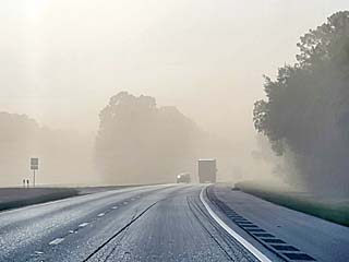
Heading through some rare haze (blowing dust) in the Florida Panhandle area (which has been very dry, unlike S Florida) after leaving on May 1, 2023. This is the first travel day starting the main chase "expedition" trip of 2023. |
|
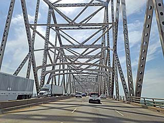
Crossing the Mississippi River near Baton Rouge late in the day on May 2. May 3 will be the final travel day into Texas. |
|
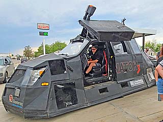
Reed Timmer and the "Dominator" chase vehicle waiting for storms at an Allsups gas station in Crowell, Texas. There was a big chaser convergence in this area. |
|
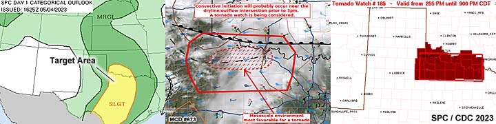
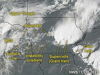
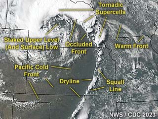
Annotated visible satellite (from around 22z) showing the synoptic environment and storm evolution on May 4, 2023. |
|
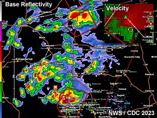
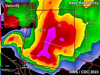
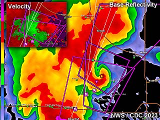
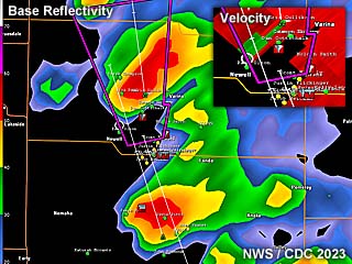
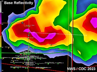
Radar imagery, showing base reflectivity, at around 4 PM CDT near Crowell, Texas on May 4. The supercell has a classic to HP look on radar. The velocity is to the lower-left inset. |
|
Storms begin initiating near the intersection of a stationary frontal boundary and dryline by mid to late afternoon west of Crowell, Texas. The view is to the southwest. |
|
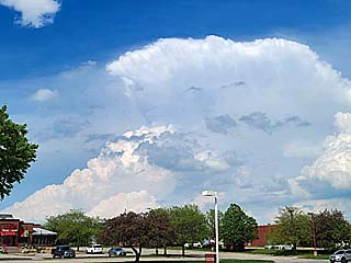
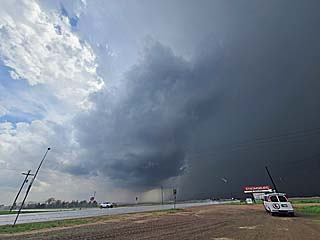
Intensifying classic / HP supercell to the south of Crowell, Texas. The view is to the southwest. |
|
Close up of rotating wall cloud on the Crowell supercell. The view is southwest. |
|
View of the leading (eastern) side of the low-level mesocyclone (note striations) of the HP supercell now southeast of Crowell. The view is to the south. |
|
Interesting inflow / scud "bombs" flowing into the north side of the wall cloud into the Crowell supercell. Very large hail is to the right. The view is to the west. |
|
View of another supercell later near Peducah, Texas. This was a classic to LP storm. The view is to the southwest. |
|
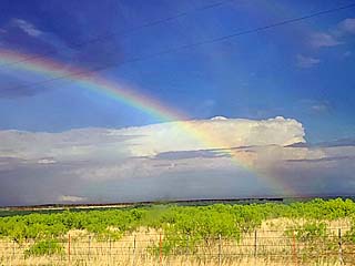
A view to the east from along Highway 70 west of Crowell allows the back-side of an MCS to be seen, with an intense supercell embedded in this storm cluster in the distance (supposedly producing a very weak tornado at the time near Bellevue). The view is to the ESE with a rainbow in the foreground from the rain from the Peducah LP storm undergoing down-scale evolution. |
|
Another small supercell tries to develop near the retreating dryline east of Dundee, Texas late in the day. The view is to the south. |
|
Annotated visible satellite (from around 22z) showing the synoptic environment and storm evolution over central Texas on May 5, 2023. |
|
Radar imagery, showing base reflectivity, at around 6 PM CDT over central Texas on May 5. The convective mode is rather messy and complex, with a "tail end" supercell to the south near Burnet, Texas. The velocity in the upper-right inset is for the supercell storm west of Burnet. |
|
Storms initiate along an old outflow boundary and east of a dryline over north Texas near Wise County. The view is to the southwest. |
|
Developing supercell near Bridgeport in Wise County, Texas during the afternoon of May 5. The view is to the south. |
|
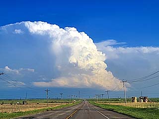
An MCS (cluster of strong and severe storms) looms near Comanche, Texas during the early evening of May 5. Unfortunately I was not able to reach the tail-end supercell in this storm cluster before dark. The view is to the south. |
|
Annotated visible satellite (from around 23z) showing the synoptic environment and storm evolution again over central Texas on May 6, 2023. |
|
Radar imagery, showing base reflectivity, at around 6 PM CDT over central Texas on May 6. There is a supercell storm to the southwest of Throckmorton, Texas with a well-defined hook echo. The velocity is in the lower-right inset. This storm produced a funnel cloud before being absorbed into a severe storm cluster. |
|
Convective initiation looking northward out of Abilene, Texas during the afternoon of May 6. |
|
Supercell storm to the southwest of Throckmorton, Texas. The view is to the west. Note the RFD and funnel to the lower left. |
|
Close up of low level mesocyclone with RFD and funnel / wall cloud. The view is to the southwest. |
|
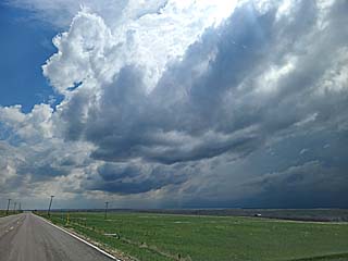
Incredible mammatus clouds at sunset south of Lawton, Oklahoma on the backside of the MCS to the south and east. The view is to the west. |
|
Annotated visible satellite (from around 22z) showing the complex synoptic environment and storm evolution over central Iowa on May 7, 2023. |
|
Radar imagery, showing base reflectivity, at around 5:30 PM CDT near and east of Oskaloosa, Iowa on May 7. This is an HP supercell storm at this point, producing very large hail at the time. The storm velocity is in the upper-left inset. |
|
Storms initiate on the southern end of an area of storms pushing just north of Des Moines, Iowa during the afternoon of May 7. These are following a stationary frontal boundary and instability axis. The view is to the northeast. |
|
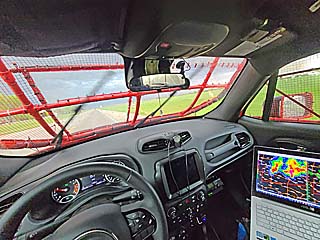
View from inside my chase vehicle (near Grinnell, Iowa) with much-needed hail guards installed. |
|
View of storm mesocyclone and wall cloud near Oskaloosa, Iowa. The view is to the south. |
|
Very large hail, with some sizes in excess of 2", bouncing in the street near Richland, Iowa. |
|
Wall cloud and dust looking south towards the main updraft of the supercell (just about to evolve to a line segment) near Richland, Iowa. |
|
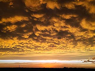
Mammatus on the backside of the storms near Mount Pleasant, Iowa. The view is to the north. |
|
Sunset viewed looking west as the chase ends and I head to Ottumwa, Iowa for the night. |
|
Annotated visible satellite (from around 23z to near 0z the following day) showing the synoptic environment and storm evolution over the area(s) of interest on May 8, 2023. |
|
Radar imagery, showing base reflectivity (close-up), at around 6 PM CDT near Camdenton, Missouri on May 8. This was a supercell embedded in a line segment at this point. The storm velocity is in the upper-right inset. |
|
Storms initiate along a line over southwestern and south-central Missouri. This is near Camden County. The view is to the northwest. |
|
Approaching a supercell storm embedded in a line-segment of strong and severe thunderstorms near Camdenton, Missouri. The view is to the northwest. |
|
View of storm mesocyclone and wall cloud near near Camdenton, Missouri. The view is to the northwest. |
|
Rotating area of the storm, and possible funnel cloud, near Camdenton, Missouri just before the storm became rain-wrapped / undercut by outflow. The view is to the WNW. |
|
Annotated visible satellite (from around 23z) showing the synoptic environment and storm evolution over the area(s) of interest on May 9, 2023. An on-going MCS is moving northwest to southeast from central to eastern Kansas. The supercell storms are southwest of that area, mainly outflow dominant and producing very large hail. |
|
Radar imagery, showing base reflectivity, at around 5 PM CDT southwest of Radium, Kansas on May 9. This was one of several intense supercells to the southwest of a large MCS, and were outflow dominant. The storm velocity on one of the more intense storms (also southwest of Radium) is in the lower-right inset. |
|
Gust front and shelf cloud south of Mc Phereson, Kansas while heading north on I-135 during the afternoon on May 9. This is the outflow associated with the MCS on-going to the northeast at the time. |
|
Supercell storm being targeted near Great Band, Kansas. The view is to the west along Highway 56. |
|
View of updraft base and HP mesocyclone of an HP storm near Saint John, Kansas. The view is to the northwest. |
|
Another view of the HP storm and wet RFD shelf cloud looking north from Highway 50 in Reno County. |
|
Wind-driven hail and 75+ MPH winds hitting Turon, Kansas. |
|
View of HP supercell / line segment near Pratt, Kansas. The view is to the southwest. |
|
Hail accumulated on the ground after passage of supercell storms in Pratt, Kansas. |
|
Lightning illuminated supercell near Rush Center, Kansas after dark. The view is to the north on Highway 183. |
|
Hail across Highway 183 after dark near Rush Center. |
|
Annotated visible satellite (from around 21z) showing the complex synoptic environment and storm development over the area(s) of interest on May 10, 2023. Storms are developing in an area of low pressure near a surface boundary and up-slope wind flow, with storms in NW Kansas as well, developing near a dryline. |
|
Radar imagery, showing base reflectivity, just before 4 PM MDT of a supercell storm east of Castle Rock, Colorado. This was one of the first intense supercells before it weakened due to cool air. Note the intense hail core (white area at over 70 dbz). The storm velocity is in the lower-right inset. |
|
Storm initiation looking southwestwards from north of Kiowa, Colorado during the afternoon of May 10. A tornado-warned storm is developing east of Castle Rock at the time. |
|
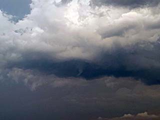
Ominous area of broad rotation on the southeastern side of the Castle Rock supercell near The Pinery, Colorado before becoming outflow dominant and weakening. The view is to the west. Note the funnel to the right. |

|
View looking northeast while stopped near a construction zone on SR 71 north of Last Chance, Colorado. A landspout tornado (with a 2nd one possible to its left) is developing to the lower right as a chase tour group looks on. |
|
Closer view of the landspout tornado(es) looking northeast from SR 71 north of Last Chance. |
|
Hail covering the roadway (Highway 34) between Brush and Akron, Colorado. |
|
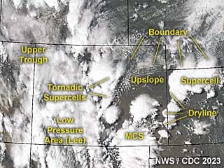
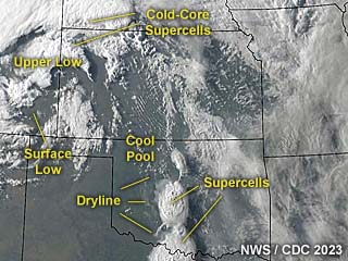
Annotated visible satellite (from just before 0z the next day) showing the complex synoptic environment and storm development over the area(s) of interest on May 11, 2023. Both the target areas, the one to the northwest (cold-core) in NW Kansas, as well as the dryline setup over SW Oklahoma, produced tornadoes. |
|
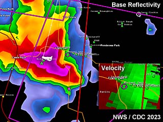
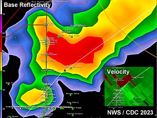
This is a radar image (base reflectivity) of a potentially tornadic supercell north of Rush Springs, Oklahoma at roughtly 7 PM CDT. The velocity is in the lower-right inset. |
|
Storms initiating in south-central Oklahoma along the dryline, with a highly-sheard LP supercell forming near Commanche County. The view is to the west. |
|
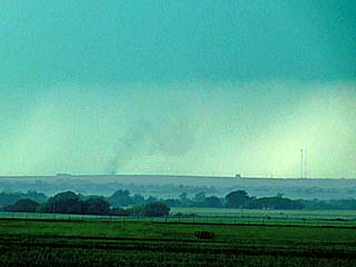
Weak landspout type tornado on a developing supercell storm near Commanche County, Oklahoma. This looked like smoke or dust, but was rotating. The view is to the west. |
|
Weak, broad, multi-vortex tornado near Agawam, Oklahoma. The entire base / wall cloud was strongly rotating, and brief spin ups were noted under it. The view is to the northwest. Note the smoke on the ground being pulled into the storm from right to left. |
|
Close-up of weak circulation reaching the ground under the weak tornado near Agawam, Oklahoma. |
|
Storm occlusion near Agawam, Oklahoma, with a "cinnamon bun" type swirl in the sky overhead. The view is to the northwest. |
|
View looking west at a rapidly rotating mesocyclone and RFD region SW of Dibble, Oklahoma on May 11. There was a weak, multi-vortex circulation reported by other chasers with this storm. The view is to the northeast. |
|
Impressive low-level mesocyclone with the supercell as it passes near Grady County, Oklahoma looking north near Dibble. |
|
Small funnel / possible tornado forms from the supercell as it passes near Dibble, Oklahoma. The view is to the north. |
|
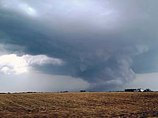
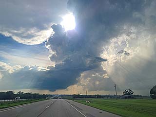
Beautiful LP supercell storm (with rotating wall cloud) at dusk southeast of Chickasha and near Bradley in Grady County, Oklahoma. The view is to the southwest. Color is REAL. |
|
This an annotated visible satellite image at roughly 22z (late afternoon) on May 12, 2023. An upper level low churnes to the upper-left in the image, with an occluded front / dryline extending east and southeast from there. The target area is to the east of the upper low (powerful cold-core setup). |
|
This is a radar image (base reflectivity) of a violent (and tornadic) supercell in Dodge County, Nebraska at roughtly 5:30 PM CDT. The incredible signature of a significant tornado is unmistakable. The impressive velocity is in the upper-left inset as well. |
|
View looking west from the Kansas / Nebraska border. The cloud banding in the mid levels can be seen in the sky, associated with the strong upper-level low to the northwest. |
|
Storms initiating over central to NE Nebraska, with a small LP supercell forming as a tour group to the lower right watches. A large arcing line of supercell storms would form, with already a large tornado on-going to the NW near Spalding (I did not see that one). |
|
Hasty punch through an tornadic HP supercell core headed eastbound in Platte County near Humphrey, Nebraska at roughly 5:15 PM CDT. Winds here are over 70 MPH, with a possible tornado forming just to the right. |
|
View of brief tornado on the eastern side of a supercell storm near Humphrey, Nebraska at roughly 5:30 PM CDT in Platte County. The view is to the west, with the tornado near the center of the picture. I will leave this supercell and target another one father southeast (in Dodge County). |
|
View looking south just after entering the "bears cage" of a violent supercell just east of Scribner, Nebraska while rushing east to get in front of the tornado. I am experiencing 50+ knots inflow winds from the east and northeast at the time, and a wide, dusty, multivortex tornado is clearly visible. |
|
View looking west from Highway 77 towards Scribner, Nebraska in Dodge County at just after 6 PM CDT on May 12. Picture is enhanced as the storm is a violent HP supercell, and a wedge tornado is clearly seen in this picture. |
|
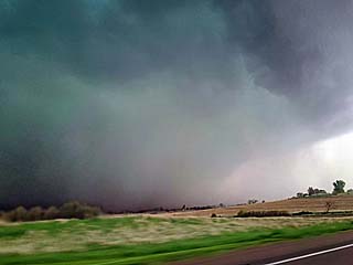
View looking towards the west and northwest at the HP supercell "notch" as the storm was west of Uehling, Nebraska at roughly 6:15 PM CDT. The wet RFD (from left to right) is hiding the massive tornado within. |
|
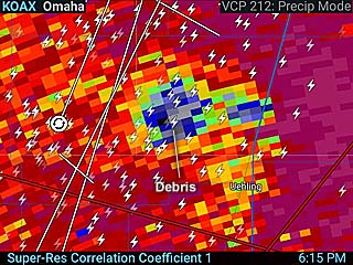
This is a radar image as the tornado-producing HP supercell was just west of Uehling, Nebraska around 6:15 PM CDT. The radar product is correlation-coefficient and shows a distinct TDS (tornado debris signature) as a blue area - Where debris is lofted by the tornado and pulled up to high altitude (signifies a signigicant tornado). |
|
Continuing north of Uehling and approaching Oakland, Nebraska - A brief view of the wedge tornado can be seen. The right edge of the wedge tornado is visible just right of the center of the picture on the horizon. The view is to the west and northwest. |
|
This an annotated visible satellite image at roughly 20z (mid to late afternoon) on May 13, 2023. An upper level low is weakening to the upper-left in the image, with an occluded front extending southeast from a surface low under the upper low. The target area is to the east of the upper low and along the warm-frontal occlusion (cold-core setup). |
|
This is a radar image (base reflectivity) of a arching line of supercells at roughly 4:30 PM CDT north of Sac City, Iowa. These were mainly low-topped mini supercells. The subtle velocity is in the upper-right inset as well. |
|
Line of developing storms over NW Iowa during the early afternoon of May 13. This is associated with an occluded front and approaching DVA region / cold-core aloft with a surface low. The view is to the northeast while heading east on Highway 20. |
|
Region of the occluded front and highly-agitated / towering cumulus clouds where vorticity is maximized. The view is to the northeast. |
|
Developing tornado and funnel (to the left) looking south near Storm Lake, Iowa just before 2 PM CDT on May 13. |
|
Contact swirl from a tornado in an open field as it makes ground contact about 1/4 mile from my location looking southwest while south of Storm Lake, Iowa just before 2 PM CDT on May 13. The tornado fortunately missed the houses in the background. |
|
Supercell storm and low-level mesocyclone near Sac City, Iowa. These supercells were small classic storms, and low topped (about 30,000 feet high) with most rotation in the lowest 3 KM of the troposphere (typical of cold-core setups). |
|
Impressive RFD clear slot near Sac County, Iowa in the foreground, and a tornado in progress in the background! The view is to the north and northwest. |
|
Impressive wedge / multi-vortex tornado looking northeast from near Fonda, Iowa. |
|
Another tornado forms in Sac County, Iowa as one supercell after another moves NNW along the occluded front, and encounters a small area of enhanced vorticity transecting the front (a boundary of some sort?). The view is to the northwest. |
|
View from Highway 20 from near Manson, Iowa of the last supercell in the distance over the horizon. The view is to the northwest. |
|
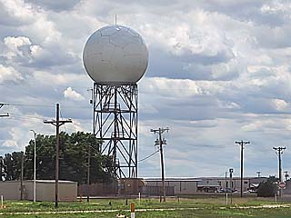
The period from May 14 to May 24 was slow / down time, mainly spent in the Chicago area. I returned out to the TX Panhandles area on May 24 and 25. This is a picture of the Amarillo WSR-88D radar, which will be very important for severe weather near the TX / NM border given that the Cannon AFB radar in New Mexico was down at the time. |
|
This an annotated visible satellite image at roughly 1z (evening) on May 25, 2023. Supercell storms are erupting at dusk just west of the TX / NM border in up-slope wind flow ahead of a slow-moving upper trough. |
|
This is a radar image (base reflectivity) of supercell storms near and east of Tucumcari, New Mexico at roughly 8:45 PM MDT. The radar presentation is impressive, given this was using the Amarillo radar site, with the closest radar, Cannon AFB in NM, inoperative. Velocity is in the upper-left inset. Also note the prominent hail-spike (extending out of the storm and to the left) in the reflectivity image! |
|
Approaching a supercell storm at dusk heading west on I-40 near the TX / NM border on May 25. The storm is east of Tucumcari, New Mexico. The view is to the west after sunset (dark). |
|
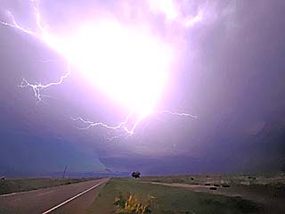
One of many incredible lightning strikes looking west towards the supercell core and updraft near Bard, New Mexico after dark. |
|
This an annotated visible satellite image at roughly 1z (evening) on May 26, 2023. Supercell storms are once again ocurring over New Mexico in up-slope wind flow / boundary interactions ahead of a slow-moving upper trough. |
|
This is a radar image (base reflectivity) of a supercell storm northwest of Clovis, New Mexico at roughly 8 PM MDT. The radar presentation was using the Amarillo radar site, with the closest radar, Cannon AFB in NM, inoperative. This is when strong rotation was noted with this storm, with funnel clouds produced. |
|
Convective initiation and a developing supercell storm looking to the northeast and headed towards Fort Sumner, New Mexico and Curry County during the afternoon of May 26. |
|
Intensifying supercell storm, banding, and striations looking north to the northwest of Clovis, New Mexico. |
|
Rotating wall cloud and low base very close to the ground roughly 20 miles northwest of Clovis, New Mexico. The view is to the north. |
|
Funnel (right) and area of rotation looking northeast from the rear-flank of the supercell storm in Curry County, New Mexico northwest of Clovis. |
|
Distant hail swath and hail fog after passage of the supercell core in Curry County. Note the hail fog. The view is NNE. |
|
Rapid rotation and bowl lowering as the storm continues eastwards north of Clovis over Curry County. I was not able to confirm any ground contact at this vantage. The view is to the NNE. |
|
Rapid rotation looking northward from under the RFD region of the supercell in the "bear's cage". There were several funnels created by this storm. |
|
RFD (rear-flank downdraft) cut and clear-slot. Sinking air behind the low-level mesocyclone and tornadocyclone erodes a slice into the supercell, with an impressive view of the "internal structure" / striations, like slicing a layered cake. The view is to the northwest. |
|
This an annotated visible satellite image at roughly 23z (early evening) on May 27, 2023 showing the synoptic environment. Supercell storms are occurring over New Mexico (and SE Colorado) in up-slope wind flow / boundary interactions ahead of an upper trough. |
|
This is a radar image (base reflectivity) of a supercell storm north of Fort Sumner, New Mexico at roughly 6:30 PM MDT. The radar presentation was using the Lubbock radar site, with the closest radar, Cannon AFB in NM, still inoperative. This is when strong rotation was noted with this storm, with a large funnel / possible tornado observed between House and Fort Sumner. The velocity is in the upper-right inset. |
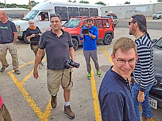
|
Amazing storm chaser "convergence" (gathering) at an Allsups gas station on May 27. To the right is "Pecos" Hank Schyma (with the long hair) and Dan Shaw (center) from Australia. |
|
Brief funnel cloud associated with an MCS southwest of Floyd, New Mexico. This was an area of rotation embedded in the north side of a bow segment. The view is to the southwest. |
|
View looking northwest from Roosevelt to DeBaca County at a powerful supercell developing near Lake Sumner, New Mexico during the early evening of May 27. |
|
Rotating wall cloud and rear-flank of intensifying supercell near Lake Sumner. The view is to the northwest. |
|
Impressive supercell structure looking west from southwest of House, New Mexico at roughly 6:45 MDT. The intense rotation and RFD region can be seen to the lower-center of the photo. Note the inflow band from right to left and "stacked-plates" appearance of the updraft / mesocyclone. |
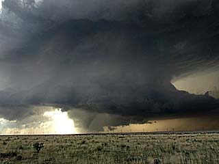
|
A large funnel / possible tornado develops under the supercell, in the lower-center of this picture. |
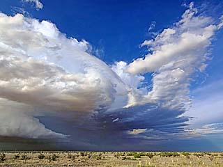
|
Down-scaling of the supercell near House, NM. Amazing structure with mid-level rotation and cloud banding clearly evident. The view is to the north. |
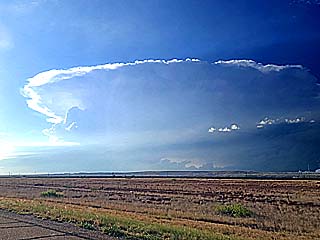
|
Another smaller supercell pops up again near Lake Sumner. This one weakened due to cool air from the previous one. The view is to the northwest. |
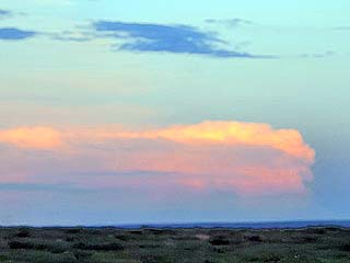
|
Distant supercell viewed from Curry County, New Mexico at dusk. The view is to the southeast. |
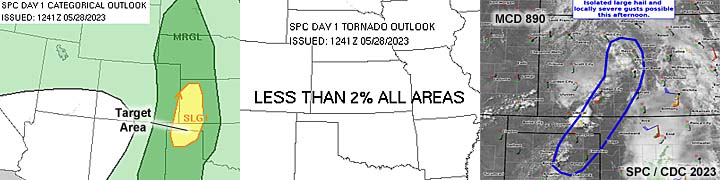
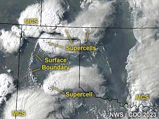
|
This an annotated visible satellite image at roughly 0z (evening) on May 28, 2023 showing the synoptic environment. Supercell storms are occurring over the Texas and Oklahoma Panhandles. Note the distinct surface boundary pushing slowly west as well. Upper air support for storms was negligable. |
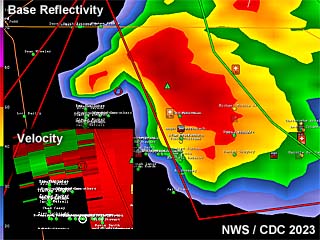
|
This is a radar image (base reflectivity) of a powerful tornadic supercell storm southeast of Stratford, Texas at roughly 7 PM CDT. This is when the storm was producing tornadoes, with a highly unusual (deviant left-split) motion to the northwest. The velocity is in the lower-left inset. |
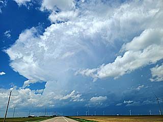
|
Supercell storm initiating early on in the afternoon of May 28 near Turpin and Balko, Oklahoma. The view is to the north. |
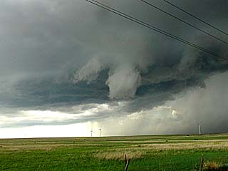
|
Funnel cloud rotating on the rear-flank / southern side of the Beaver County, Oklahoma supercell. The view is to the northwest. |
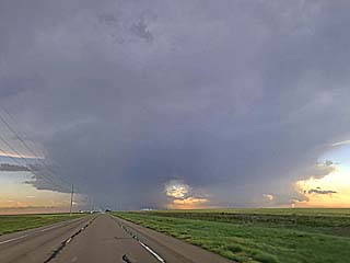
|
View looking southwestward while targeting storms near Sherman County, Texas and passing Perryton. Note the distinct split in the supercell. The left-split (to the right in this picture) would become the major tornadic supercell, which is rather unusual. The right-split (to the left) would drop some large hail and eventually dissipate, with the aformentioned left-split moving NORTHWEST and producing tornadoes southeast of Stratford later on. |
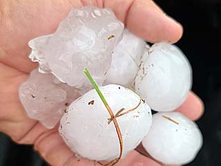
|
Hail (at least golf-ball sized) southwest of Stinnett from the right-split storm. These were partially melted and collected from the side of the road. |
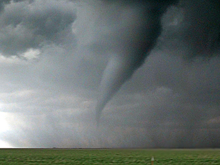
|
Beautiful tornado southeast of Stratford, Texas. The view is to the west and northwest. |
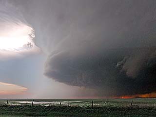
|
Stacked-plates supercell structure from the powerful tornadic supercell southeast of Stratford. The view is to the southwest. |
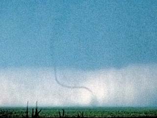
|
Another rope tornado southeast of Stratford. The view is to the west. |
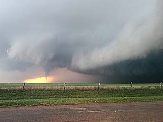
|
View of supercell rear-flank and another tornado southeast of Stratford before the storm merged with a crashing MCS to the northwest. The view is to the west. |
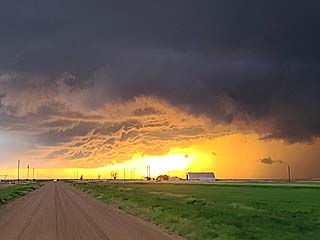
|
View to the west as a "crashing" MCS (line / cluster of severe thunderstorms) catches up and undercuts the tornadic supercell. The sun is setting and allowing for these incredible colors. Note the "whales mouth" (center of picture) as the outflow / gust front pushes from right to left. |
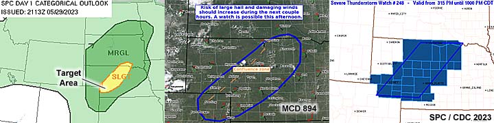
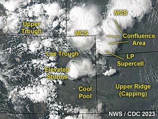
|
This an annotated visible satellite image at roughly 23z (early evening) on May 29, 2023 showing the synoptic environment. A confluence area extends from NE to SW across Nebraska, with supercell storms developing in the SW portions of that area. |
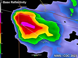
|
This is a radar image (base reflectivity) of an LP to classic supercell storm in southwest Nebraska southeast of Imperial at roughly 7 PM CDT. The storm has a solid hail core and is slowly moving NE at less than 15 knots. |
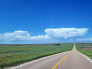
|
Storms initiating in a confluence (low-level convergence) region in SW Nebraska in the target area as I head north on SR 27 north of Goodland, Kansas on May 29. The build-up / tower to the left will form into an LP supercell in Chase County, Nebraska. The view is to the north. |
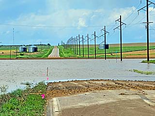
|
SR 61 blocked by flash flooding from heavy rains over the previous days south of Chase County, Nebraska. Some people were even trapped in their homes out of frame to the right. |
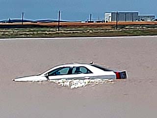
|
Car floating in floodwaters during this past weeks storms and torrential rains. |
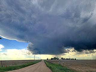
|
LP supecell storm looking west in Chase County and southeast of Imperial, Nebraska. |
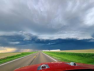
|
Gust front and shelf cloud ahead of a cluster of strong and severe storms near Holyoke, Colorado. |
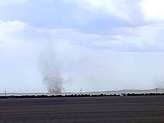
|
Gustnado / small land spout spinning up south of Highway 6 east of Holyoke, Colorado. |

|
Part of the Denver skyline as I decided to wrap up the day and spend the night in Denver. |
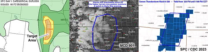
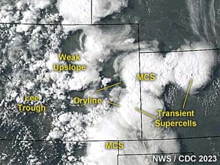
|
This an annotated visible satellite image at roughly 23z (early evening) on May 30, 2023 showing the synoptic environment. This was a subtle setup, with a weak dryline and low pressure trough / boundaries driving multi-cellular storms with minimal upper level support. |
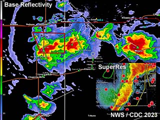
|
This is a radar image (base reflectivity) of convective activity over western and southwest Kansas at roughly 6 PM CDT. The storms were mainly multi-cell with some brief supercell structures. The lower-right inset shows storms later on as they were producing strong winds. |
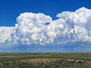
|
Convective initiation along and ahead of the dryline near the CO / KS border east of Arapahoe during the afternoon of May 30. The view is to the east and northeast. |
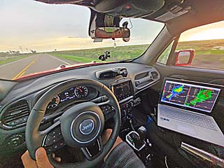
|
View inside of my chase vehicle while racing south on SR 27 north of Tribune, Kansas. |
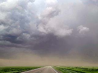
|
Powerful outflow winds gusting at times to near 70 MPH blow from right to left north of Tribune, Kansas as the MCS approaches. The view is to the south. |
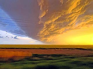
|
Incredible lightning along shelf cloud and "whale's mouth" near Syracuse, Kansas at dusk. The view is to the south. |
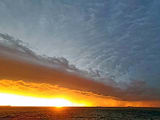
|
View of sunset and shelf cloud associated with the leading edge MCS gust front. The view is to the northwest. |
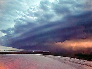
|
Gust front and shelf cloud, illuminated by lightning, approaches the area north of Liberal, Kansas after dark. Note the intense dust under the shelf cloud to the lower-right. The view is to the west. |
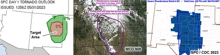
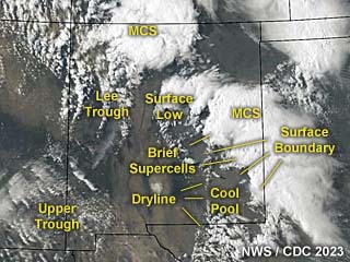
|
This an annotated visible satellite image at roughly 23z (early evening) on May 31, 2023 showing the synoptic environment. This was a more active setup, but with messy and widespread convection breaking out across eastern New Mexico and western Texas. |
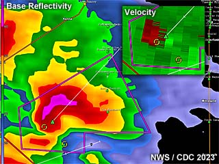
|
This is a radar image (base reflectivity) of a brief tornadic supercell storm southwest of Elida, New Mexico at roughly 5 PM MDT. A brief, rain-wrapped tornado was reported around this time. The Doppler velocity is to the lower-right inset. |
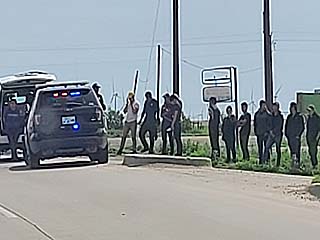
|
Interesting seeing this while passing through Guymon, Oklahoma ... Apparantly a bunch of illegal immigrants were siezed on the edge of town. This is a big problem across the remote areas of the country. At least 15 people were being smuggled in the SUV to the far left by the patrol car! |
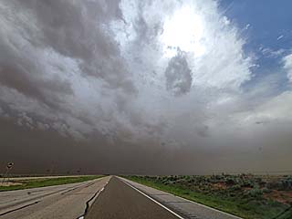
|
Convective initiation in a dusty environment south of Clovis, New Mexico and near Elida during the afternoon of May 31, 2023. The view is to the south and southwest. |
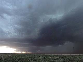
|
Potentially tornadic supercell storm moving over Roosevelt County near Minesland, New Mexico with rotating wall cloud. The view is to the southwest. |
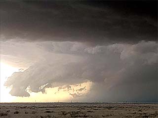
|
A brief funnel develops on this storm before becoming rain-wrapped. The funnel is to the lower-right part of this picture. The view is to the southwest. |
|
A caravan of severe storm scientists and there vehicles ahead of me near the Texas / New Mexico border. Note the DOW (Doppler on wheels) radar truck in the front of the caravan. |
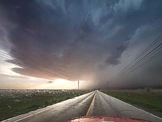
|
View of an elevated supercell storm from next to the hail core near Plains, Texas during the early evening. The view is to the west and southwest. |
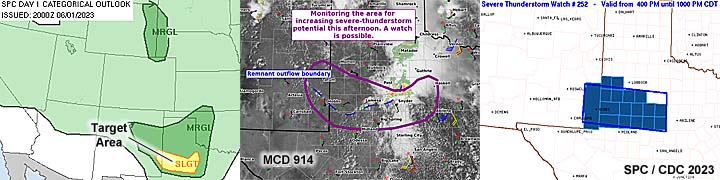
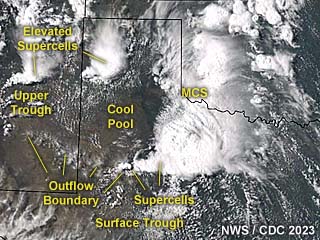
|
This an annotated visible satellite image at roughly 22z (early evening) on June 1, 2023 showing the synoptic environment. This was a complex setup, dictated by an outflow boundary and upper troughing from SW to central Texas. |
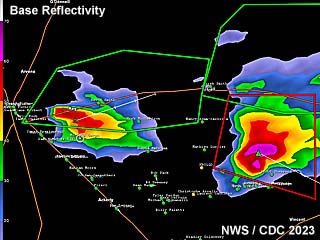
|
This is a radar image (base reflectivity) of two supercell storms east of Lamesa, Texas at roughly 5 PM CDT. The storm to the right has broad rotation and an intense hail core, but is outflow dominated. The one to the left is an elevated LP supercell. |
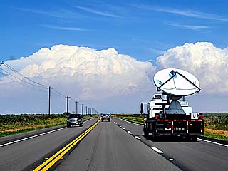
|
Storms developing on the horizon looking east from near Lamesa, Texas during the afternoon of June 1. The vehicle with the radar dish is the DOW (Doppler on wheels) operated by NOAA / NSSL. |
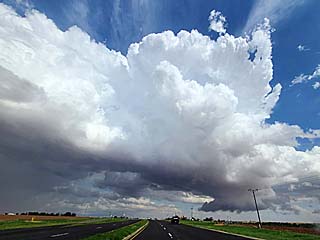
|
Developing LP supercell southeast of Lamesa with a small wall cloud to the lower right. The view is to the south and southwest. |
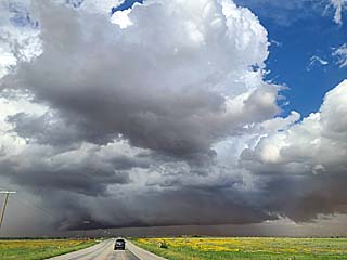
|
Outflow dominant but intense supercell storm near Ira and southwest of Snyder, Texas. The view is to the east. |
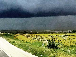
|
Close up of a possible weak landspout, just to the left of the center of the image, reported by some storm chasers as well. The view is to the east. |
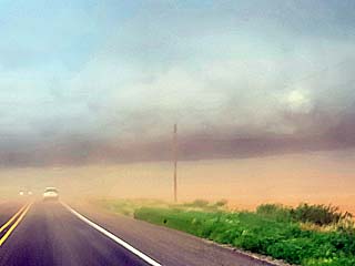
|
Blowing dust and poor visibility as outflow surges from left to right near Ira, Texas. The gust front / shelf cloud is barely visible above the horizon as well. The view is to the east. |
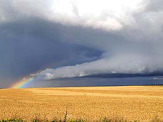
|
Rainbow and wall cloud near Ira, Texas. The view is to the east. |
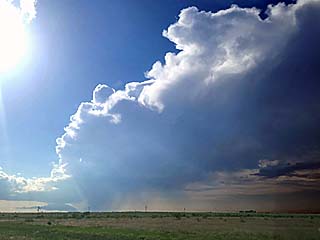
|
The Lamesa LP supercell to the west begins weakening. This was an elevated storm (undercut by outflow / cool pool). The view is to the northwest. |
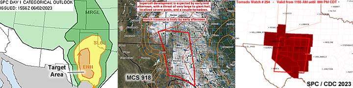
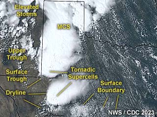
|
This an annotated visible satellite image at roughly 21z (afternoon) on June 2, 2023 showing the synoptic environment. A dryline and low-latitude (subtropical) jet stream with troughing provided support for storms from western to extreme SW Texas. |
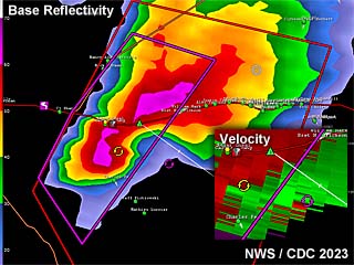
|
This is a radar image (base reflectivity) of a tornadic supercell storms east of Fort Stockton, Texas at roughly 2:15 PM CDT. The Doppler velocity of the supercell is in the lower-right inset. |
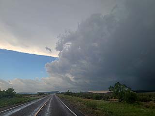
|
Approaching a tornadic supercell in Pecos County, Texas east of Fort Stockton before 2 PM CDT on June 2. A large tornado was reported near Fort Stockton and I-10 at the time, but the storm core is blocking my view of it in this picture. The view is to the south and southwest. |
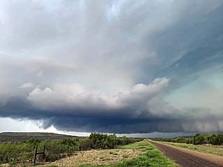
|
Developing tornado and HP supercell "notch" viewed from west of FM 2886 and about 10 miles south of Bakersfield in Pecos County, Texas. The view is to the west. |
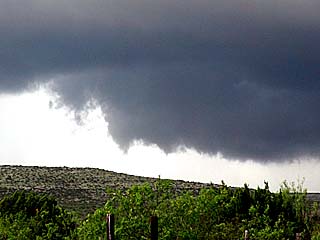
|
Wide and broad rotation / tornado looking southwest, note the funnel. There was ground "suction" spots under this large rotating system. The view is to the SW. |
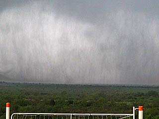
|
Rapidly tagging rain curtains and one of several "suction spots" (center of photo just above the ground). The view is to the west. |

|
Another funnel forms looking northeast from FM 2886 as the storm cycles. Note the RFD slot to the left. The funnel / developing tornado is just right of center. |
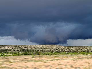
|
Large rotating wall cloud on a second storm forming behind the main one northwest of Ranch 2400 and southwest of Sheffield, Texas. The view is to the west and northwest. |
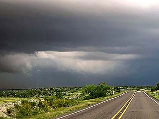
|
Enhanced view of a possible large tornado, center of photo, southwest of Sheffield, Texas. At the time, an impressive couplet and even debris ball was observed on Radar. This was roughly 4:15 CDT. The view is to the north. |
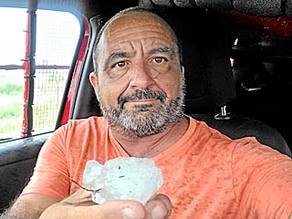
|
Hail from these storms was up to 3". Here I am holding a large hailstone southwest of Sheffield, Texas. |
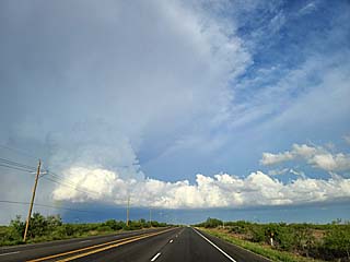
|
A weakening supercell later on southeast of Midland / Stanton, Texas during the evening. The view is to the northeast. |
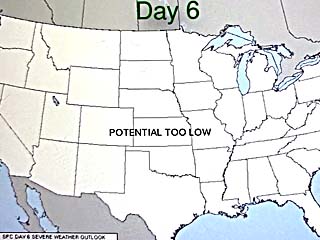
|
Two young daring folks taking the world-famous 72 oz steak challenge at the Big Texan Steakhouse in Amarillo, Texas on June 6. If you eat it all (including trimmings and sides) in 60 minutes or less, it's free! Very few can do it (these folks couldn't, but certainly did not go home hungry)! |
|
Folk music performers entertaining a table at the Big Texan Steakhouse in Amarillo, Texas on June 6. |
|
Disasterous flooding in Amarillo, Texas on June 7. Despite the lack of substantial severe weather, heavy rains day after day caused severe flooding in the normally dry city of Amarillo, closing roads. |
|
Cadillac Ranch west of Amarillo, Texas on June 7, with unusual wet and muddy conditions making for a great reflection. Anyone can paint on the cars and the area. This was an attraction since 1974. |
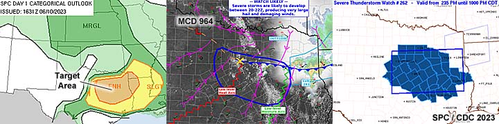
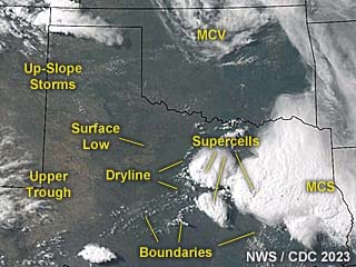
|
This an annotated visible satellite image at roughly 23z (early evening) on June 10, 2023 showing the synoptic environment. A rather complex setup exists over eastern Texas, with supercells developing near a dryline and surface boundary interactions across that area. |
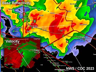
|
This is a radar image (base reflectivity) of an outflow dominant HP supercell storm / storm cluster east of Ellis and Navarro Counties, Texas at roughly 5 PM CDT. The Doppler velocity (with rain-wrapped couplet) of the supercell is in the lower-left inset. |
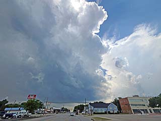
|
Convective initiation over Ellis and Navarro Counties near Ennis during the afternoon of June 10. The view is to the west. |
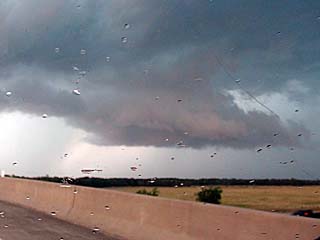
|
Wall cloud on HP supercell storm near Rice, Texas before being undercut by outflow. The view is to the west. |
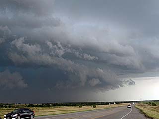
|
View of area of strong rotation being undercut by the gust front. The view is to the east and northeast. |

|
Looking at another supercell near Hood County, Texas on the western side of the storm setup. A wall cloud is visible. The view is to the northwest. |
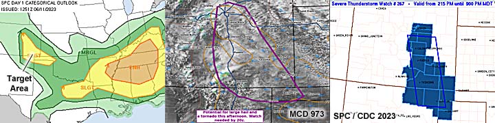
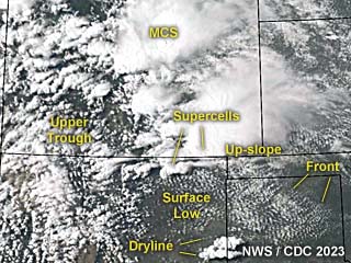
|
This an annotated visible satellite image at roughly 22z (late afternoon) on June 11, 2023 showing the synoptic environment. An up-slope wind flow, in a post-frontal environment, is causing supercell storms in southeastern Colorado ahead of an upper trough. |
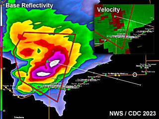
|
This is a radar image (base reflectivity) of a supercell storm producing very large hail north of Kim, Colorado at roughly 4 PM MDT. The Doppler velocity of the supercell is in the upper-right inset. The radar site is Pueblo, Colorado - Note the hail-spike extending southward out of the storm to the lower left / center of the image! |
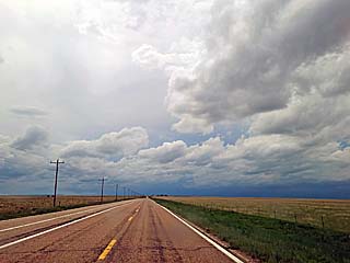
|
Looking west of Springfield, Colorado near Prichett along Highway 160 on June 11. The darkening sky is a sign a big storm is to the west. |
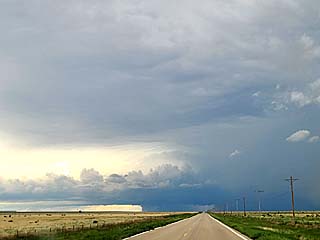
|
Approaching the storm near Kim, Colorado. The view is to the west. |
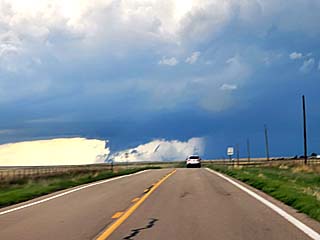
|
Looking west at the storm while near Kim, Colorado. That is NOT a tornado, its is a shelf cloud developing from the RFD gust front (and scud). The view is to the west. |
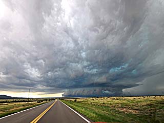
|
Wall cloud and powerful HP supercell and RFD gust front very low to the ground west of Kim, Colorado in Las Animas County. The view is to the west. |
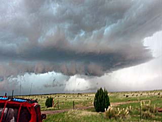
|
Hail core and intense HP storm looking northwest. |
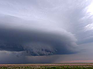
|
Wall cloud and leading edge of storm mesocyclone northwest of Boise City, Oklahoma. The view is to the north. |
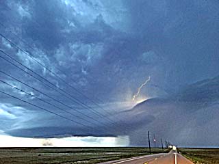
|
Lightning illuminates the weakening / down-scaling storm east of Boise City, Oklahoma after dusk. |
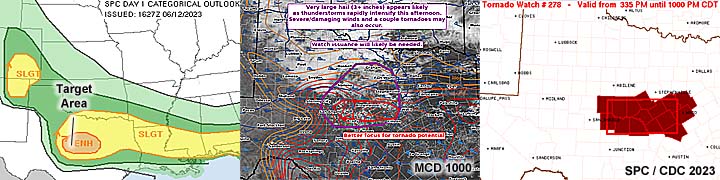
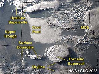
|
This an annotated visible satellite image at roughly 0z (evening) on June 12, 2023 showing the synoptic environment. A powerful tornadic supercell is going on in central Texas. |
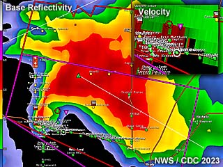
|
This is a radar image (base reflectivity) of a tornado-warned supercell storm near Brady, Texas at roughly 7 PM CDT. The Doppler velocity of the supercell is in the upper-right inset. Note the impressive hook on the reflectivity display (the storm was producing a weak tornado at the time). |
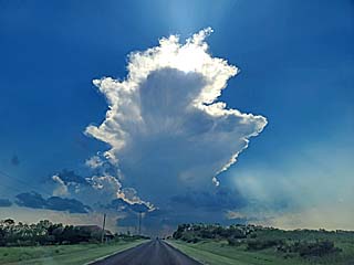
|
Convective initiation during the late afternoon near Concho County, Texas (NW of Brady) on June 12. This is where a stationary frontal boundary and the dryline intersected, known as a "triple point". The view is to the west. |
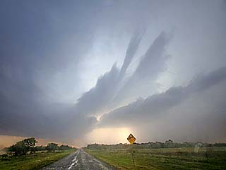
|
Inflow bands issuing into the rapidly developing supercell over Concho County. The view is to the west and northwest. |
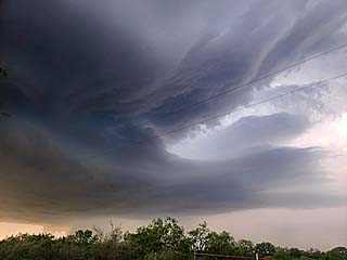
|
View of powerful updraft and eastern side of supercell with inflow bands. The view is to the north. |
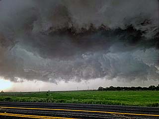
|
Intense rotation develops northwest of Brady, Texas. Some dust "swirls" were noted under this, denoting a weak tornado. The view is to the northwest. |
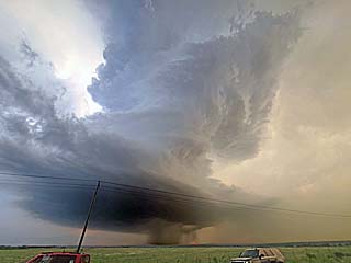
|
Weakening supercell evolving to LP mode via down-scaling, with an impressive "barber-pole" visual appearance at dusk. The view is to the northwest. |
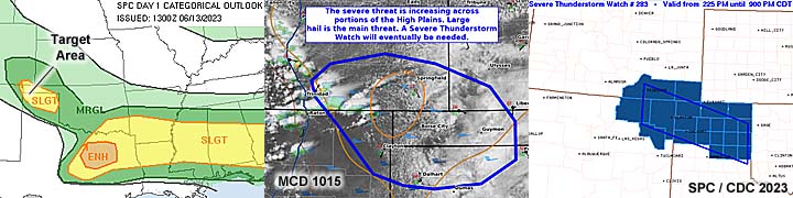
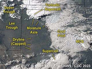
|
This an annotated visible satellite image at roughly 0z (evening) on June 13, 2023 showing the synoptic environment. Up-slope wind flow over the extreme northern OK / TX panhandles under a strong trough aloft (providing upper-level support) is causing a long-track supercell producing destructive hail swath from NW to SE (at least a 200 mile long path)! |
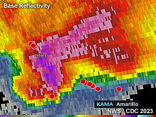
|
This is a radar image (base reflectivity) of an extremely severe tornado-warned supercell storm near Pampa, Texas at roughly 7:45 PM CDT. The storm was tornado-warned but outflow dominant, however, note the deep-purple color of the storm core - Denoting giant, wind-driven hail. Hail to 4" was reported with this storm! |
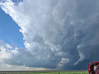
|
Approaching a tornado-warned supercell storm to the northwest of Stratford, Texas near the TX / OK Panhandle border on June 13. The view is to the northwest. |
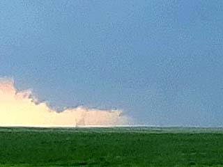
|
A small (brief) tornado develops on the new low-level mesocyclone as viewed from Ranch 807 south of Kerrick before outflow (and "gorilla" hail) undercut the storm. The view is to the west. |
|
This the TIV 2 chase vehicle, formerly owned by Sean Casey (for IMAX) passing through Borger, Texas and here in Pampa. |
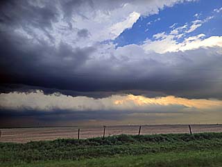
|
Interesting inflow clouds south of the supercell near Borger, Texas. This is associated with a developing low-level jet. The view is to the east and southeast. |
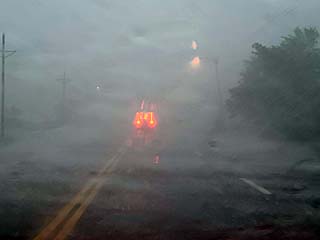
|
Near zero visibility strikes on the south side of Pampa, Texas. wind-driven hail (up to 2") and winds well over 70 MPH struck the area along a long (200+ mile) swath from extreme NW Oklahoma, across the TX Panhandle, and SE back into W Oklahoma! |
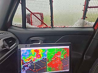
|
View inside my chase vehicle with my laptop and marble sized hail covering the bottom of the window. |
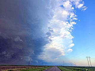
|
The gradient from extreme weather to clear-blue sky was only a couple of miles on the south end of the outflow-dominant supercell storm and gust front! The view is to the east just north of I-40. |
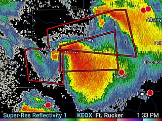
|
Incredible radar presentation (base reflectivity) of a tornadic supercell in SW Georgia (Reed Timmer reported a large tornado with this storm). Very few storm chasers headed this far east. |
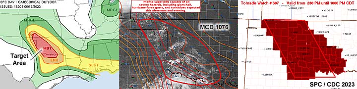
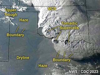
|
This an annotated visible satellite image at roughly 1z (evening) on June 15, 2023 showing the synoptic environment. Tornadic supercells are on-going in various areas - One near the Red River along the TX / OK border, as well as formerly tornadic storms that moved from the E TX Panhandle into western Oklahoma. |
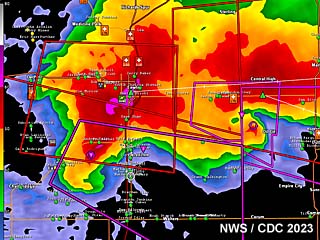
|
This is a radar image (base reflectivity) of an extremely severe and tornadic supercell with two areas of rotation (and merging) near Comanche, Oklahoma at roughly 5 PM CDT. A large tornado was produced shortly afterwards. |
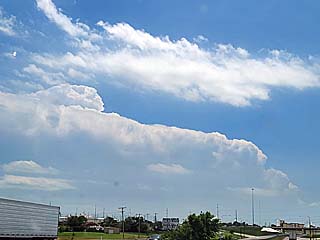
|
Convective initiation of a soon-to-be long-track tornadic supercell looking south and southwestward from the target area in Elk City, Oklahoma during the early afternoon of June 15. |
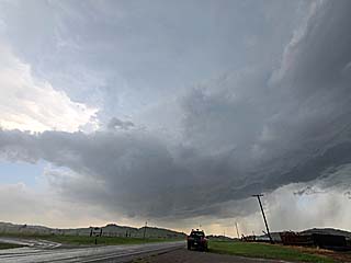
|
Developing supercell storm west of Hobart, Oklahoma. This storm was producing 3" hail at the time. The view is to the west. |
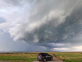
|
Powerful RFD (gusting over 60 MPH) and intensification of the low-level mesocyclone over Kiowa County, Oklahoma. The view is to the east. |
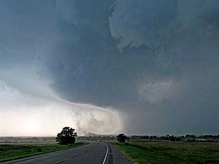
|
Possible brief tornado on leading edge of HP storm outflow south of Cache, Oklahoma. The view is to the west. |
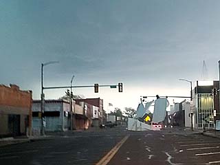
|
A roof is torn off a building and goes flying through the air, and lands at the intersection of SR 53 and Highway 81 in Comanche, Oklahoma. A large wedge tornado is developing nearby and it is rain-wrapped. |
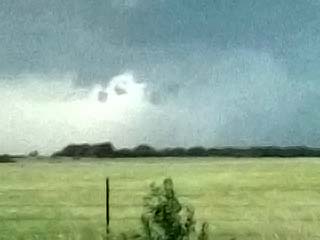
|
Brief / low-contrast view of a large wedge tornado from southeast of Comanche, Oklahoma. The wedge tornado is just right of the center of the photo. The view is to the west and northwest. |
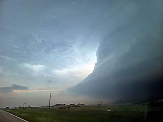
|
Southern end of the supercell storm west of Love County, Oklahoma and north of the Red River. The view is to the southwest. |
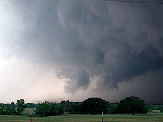
|
Brief tornado looking north towards the Red River from north of Saint Jo, Texas. |
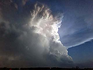
|
Incredible view of the backside of a tornadic supercell to the south of Saint Jo, Texas after dark. The view is to the southeast. Some of these storms were over 60,000 feet tall. |
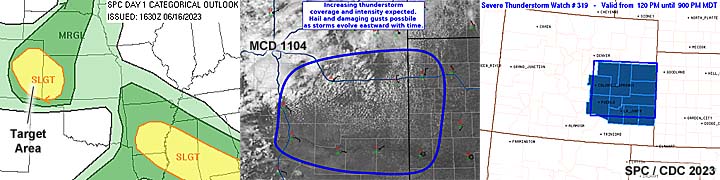
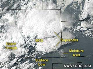
|
This an annotated visible satellite image at roughly 0z (evening) on June 16, 2023 showing the synoptic environment. Supercells are present in up-slope wind flow in an area across eastern to southeastern Colorado. |
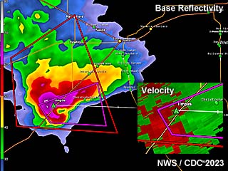
|
This is a radar image (base reflectivity) of a tornado warned supercell developing south of La Junta, Colorado at roughly 4:30 PM MDT. The storm had very large hail at the time (note the hail "spike" south of the storm), but was high-based. The modest velocity of the storm is in the lower-right inset. |
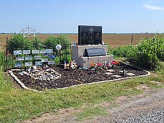
|
This is the memorial for scientists Tim (and his son Paul) Samaras and Carl Young near the corner of Reuter and Radio Roads near El Reno, Oklahoma on a sunny morning on June 16, 2013. This is over 10 years after we lost these folks in the deadly EF-5 tornado on May 31, 2013. I stopped here while passing through Oklahoma before heading to a distant target in SE Colorado. The memorial is looking better than it ever did. |
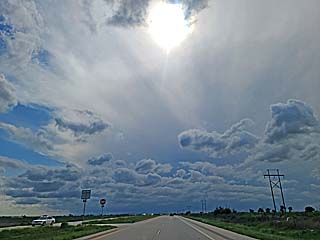
|
Looking west on Highway 50 near Lamar, Colorado during the afternoon of June 16. A supercell storm and anvil blow-off is looking over the horizon (near Las Animas and La Junta). |
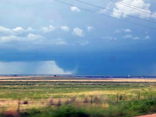
|
The Las Animas / La Junta storm drops a wet microburst of hail and rain looking southwestward from northeast of the area. |
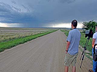
|
Scott McPartland and Dave Lewison (right) watching the developing storm near SR 101 south of Las Animas in Otero county. |
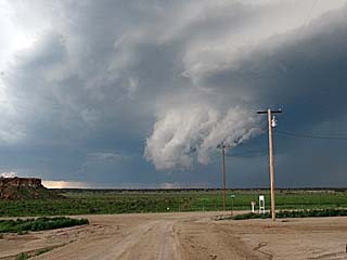
|
Rotating wall cloud as the storm interacts with an MCS to the west and back-builds southward. The view is to the west. |
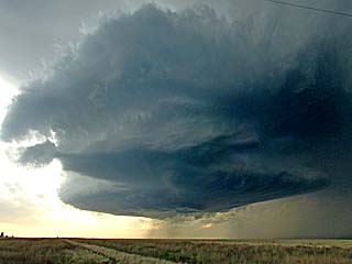
|
Storm evolves to a "tail-end Charley" LP supercell at the southern end of the MCS / severe storm complex near Prichett. The view is to the west and northwest. |
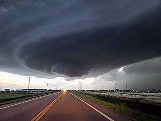
|
Impressive "stacked-plates" structure as the storm approaches Springfield, Colorado. The storm was tornado-warned at the time. The view is to the west. |
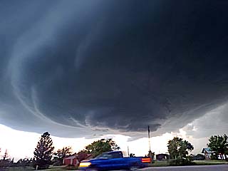
|
"Mother-ship" appearance of the LP supercell over Springfield during a fuel stop after dusk. |
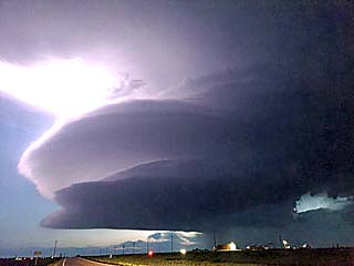
|
Wider view of LP supercell storm east of Springfield, Colorado after dark, illuminated by twilight and continuous lightning. The view is to the west. |
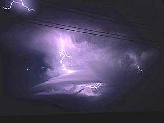
|
Lightning illuminates the mid-level structure as the LP storm nears the CO / KS border and weakens via down-scale evolution. The bright dot to the left is Venus. The view is to the west and northwest from south of Johnson City, Kansas. |
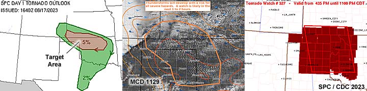
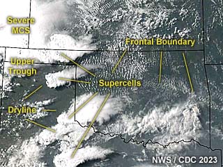
|
This an annotated visible satellite image at roughly 23z (late afternoon) on June 17, 2023 showing the synoptic environment. A tornado-warned supercell amongst other storms are present across the Oklahoma Panhandle area. |
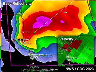
|
This is a radar image (base reflectivity) of a tornado warned supercell near Beaver, Oklahoma at roughly 6 PM CDT. The Doppler velocity of the storm is in the lower-right inset. |
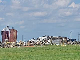
|
Damage observed on the east side of Perryton, Texas while en-route to the target area for the day on June 17. This was caused by a devastating tornado that hit the town a few days prior. |
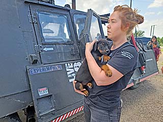
|
One of the crew members from the TIV2 rescuing two animals, one stray cat and an abandoned dog shown here, as we wait for convective initiation near Elmwood, Oklahoma. |
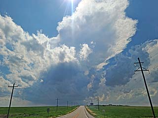
|
Rapid initiation of severe storms occurs to the west over Beaver County, Oklahoma, as the dryline approaches from the west. |
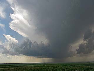
|
Explosive supercell ensues shortly after the last picture was taken. The view is to the west near Balko, Oklahoma. |
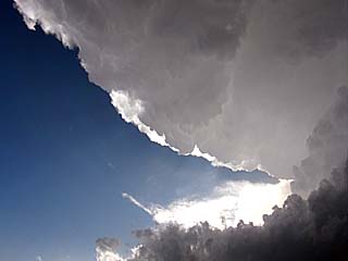
|
Rock hard anvil with "knuckles" and back-shearing, looking overhead north of Balko, Oklahoma. |
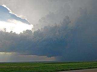
|
Classic supercell mode looking west from Highway 83 south of Turpin, Oklahoma. A wall cloud is also forming. |
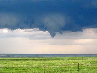
|
Funnel develops on the wall cloud and subsequent weak tornado-genesis ensues. The view is to the west and northwest. |
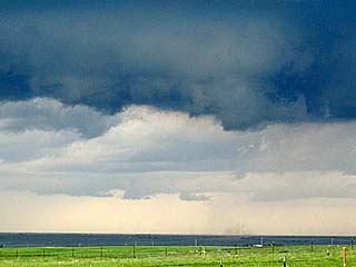
|
Weak tornado, with ground circulation confirming ground contact. The view is to the west and northwest. |
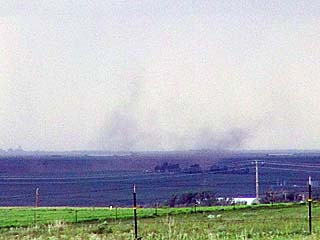
|
Close-up of ground circulation south of Turpin, Oklahoma and west of Highway 83. |

|
Rapidly rotating low-level mesocyclone crossing Highway 183 southeast of Turpin. The view is to the north. |
|
Giant hail in the roadway (up to 3") between Turpin and Beaver. |
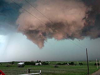
|
Funnel cloud on developing tornado south of Beaver, Oklahoma. The view is to the north and northwest. |
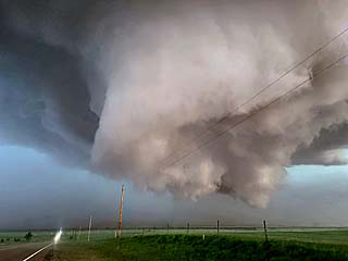
|
Incredible motion of wall cloud and funnels south of Beaver, Oklahoma nearing Highway 270. The view is to the north and northeast. |
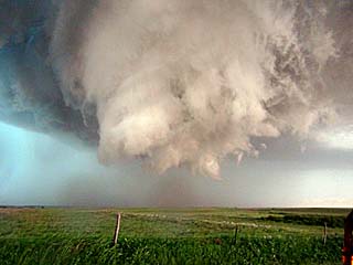
|
Possible multi-vortex tornado, albeit weak ground circulation - if any. The view is to the northeast. |
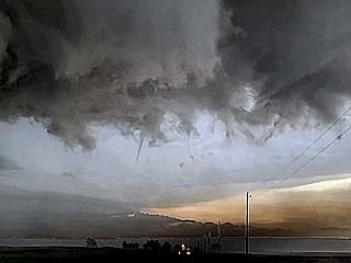
|
Needle funnel, just left of the center of the picture, racing left to right while headed east on EW 19 road. The DOW radar truck is in front of me. |
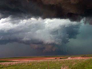
|
Wider view of intense mesocyclone with RFD clear slot and occlusion. Funnels and occasional tornadoes could be observed with this feature. The view is to the northwest with a new rain-wrapped mesocyclone forming east of there at the time. |
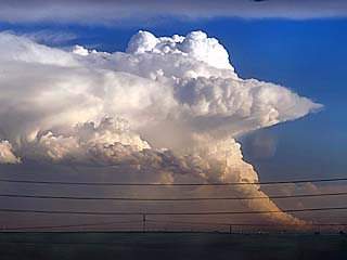
|
View of an LP supercell well to my south undergoing down-scale evolution near dusk. |
|
View north of Highway 270 near May, Oklahoma of the intense HP supercell just as a powerful MCS was catching up with it. This is the hail laden, wet RFD. The view is to the north. |
|
Incredible shelf cloud and gust front associated with a powerful derecho-like MCS racing eastward just after sunset! The view is to the southwest. |
|
The Central USA is sometimes called the "fly-over" states. Here an airliner at high (cruising) altitude overflies Wichita, Kansas on June 19. |
|
Interesting sculture / whirly-bird garden from a late sculptor in western Kansas along Highway 400 on June 20th. |
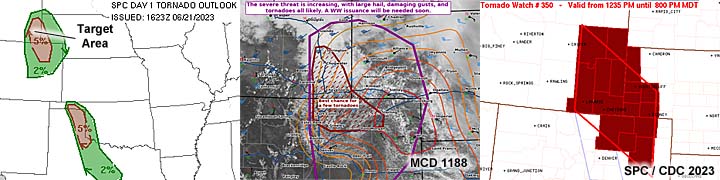
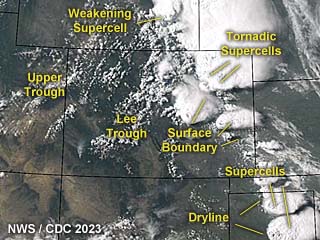
|
This an annotated visible satellite image at roughly 23z (late afternoon) on June 21, 2023 showing the synoptic environment. Tornadic supercells are on-going in NE Colorado (and the Texas Panhandle) with less intense storms in SE Wyoming. |
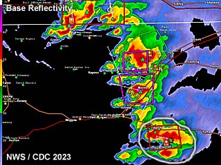
|
This is a radar image (base reflectivity) of a line of supercells over NE Colorado during the afternoon of June 21, at about 4 PM MDT. The southern most storm, circled, would produce a significant tornado south of Akron in Washington County. |
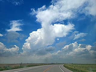
|
Storm initiation while en-route to the main target area (of SE Wyoming) passing south of Sterling, Colorado on June 21. This would be the correct target area of the day, not the one in Wyoming. |
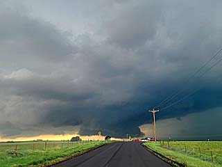
|
Wall cloud on intense supercell near Sterling, Colorado. The view is to the west. |
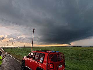
|
Intense Logan County supercell near Sterling, Colorado. The view is to the southwest. |
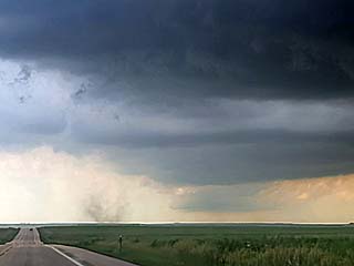
|
Brief land-spout type tornado (dust swirl on ground just right of Highway 6) southwest of Sterling, Colorado before the supercell became temporarily undercut by outflow. The view is to the west. |
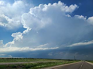
|
LP supercell northwest of Chugwater, Wyoming. The view is to the northwest. |
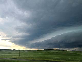
|
Shelf cloud and gust front of supercell evolving to a line segment west of Chugwater, Wyoming. The view is to the west. The correct decision today would have been to stay with the Logan County storms in Colorado! |
|
Copious amounts of pea-sized hail laying on the ground during overnight thunderstorms near Stapleton, Colorado east of Denver. |
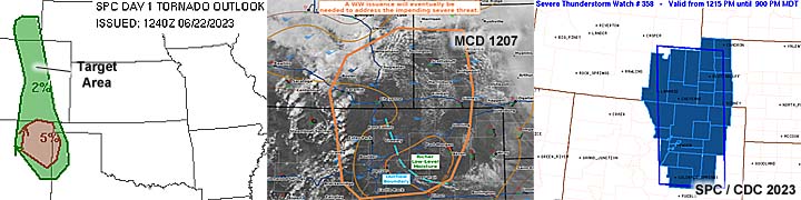
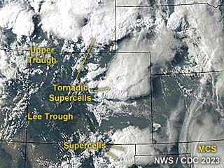
|
This an annotated visible satellite image at roughly 0z (late afternoon) on June 22, 2023 showing the synoptic environment. Tornadic supercells are near Denver, Colorado and northward into SE Wyoming. |
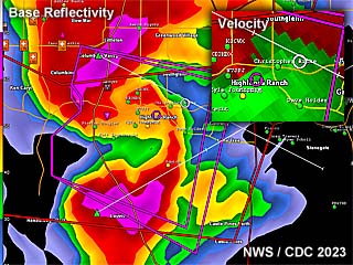
|
This is a radar image (base reflectivity) of a tornadic HP supercell south of Denver, Colorado at roughly 3:30 PM MDT during the afternoon of June 22. A large, rain-wrapped tornado was hitting the area near Lone Tree at the time. The velocity is in the upper-right inset. |
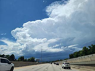
|
Initiation of severe thunderstorms west of Denver, Colorado over the Front Range (orographic lift) on the early to mid afternoon of June 22. The view is to the west. |
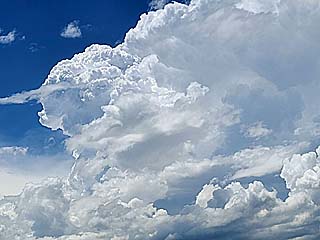
|
Explosive development of a soon-to-be supercell storm to the west-southwest of Denver as the upper wave / trough slowly advances eastward. |
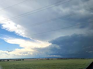
|
Wide view of intensifying supercell storm to the southwest of Denver (from the east, looking southwest). |
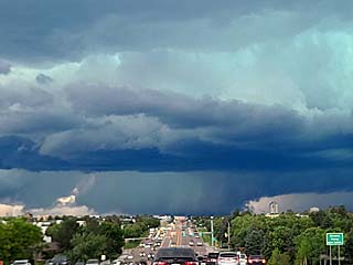
|
Large rotating wall cloud looking westward from Parker / Centennial, Colorado along Arapahoe Road as the storm approaches Littleton. |
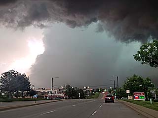
|
Large tornado (center of photo) and complete RFD occlusion moving southeastward towards Highway 470 and Highlands Ranch. The view is to the west. |
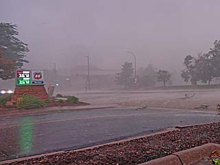
|
Intense winds, and hail, gusting probably over 100 MPH as rear-inflow of the now large, rain-wrapped tornado, passes near Highlands Ranch, Colorado. |
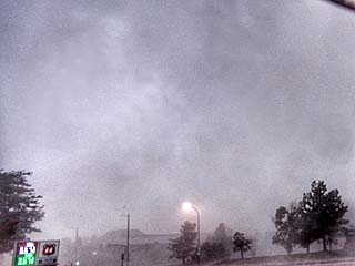
|
View of sky (sorry for the rain drops) of clouds racing left to right, with the edge of the tornado barely visible from the center to the upper-right of the photo. The view is to the northeast. |
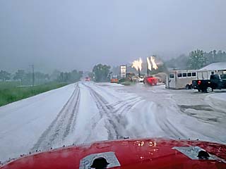
|
Hail covers the ground, at least 6" deep in places, in Elbert, Colorado behind another developing tornadic supercell moving southeast on the tail-end of a large bow segment of severe storms. |
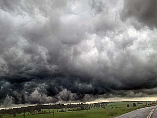
|
Incredible "whales mouth" cloud formation on the backside of a supercell north of Peyton and southeast of Elbert, Colorado. The view is to the southeast. |
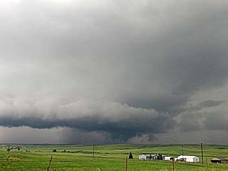
|
Powerful supercell and possible weak tornado, just below and right of the center of the photo, looking northwest from near Ramah / Simla, Colorado. The storm weakened via down-scaling thereafter. |
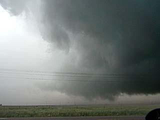
|
Developing weak tornado (lower-center of photo) near Peyton, Colorado near dusk. Note the wet RFD to the left. The view is to the north. |
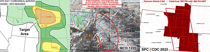
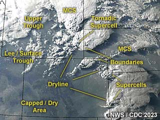
|
This an annotated visible satellite image at roughly 1z (early evening) on June 23, 2023 showing the synoptic environment. A cyclic tornadic supercell is moving from SE Wyoming into western Nebraska. |
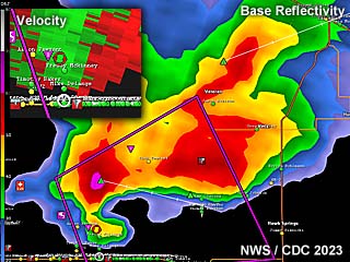
|
This is a radar image (base reflectivity) of a tornadic HP supercell over Goshen County, Wyoming at just before 6 PM MDT during the early evening of June 23. This cyclic storm was in the midst of producing multiple tornadoes. The velocity is in the upper-left inset. |
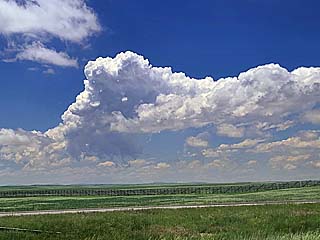
|
Convective initiation in the target-area near the triple-point of the sharpening dryline to the west and stationary boundary to the north and southwest of Chugwater, Wyoming during the early afternoon of June 23. The view is to the west. |
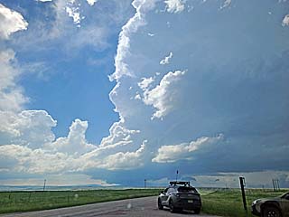
|
Convection west of Chugwater quickly explodes into a full-fledged supercell storm in under an hour. The view is to the west from just east of Chugwater. |
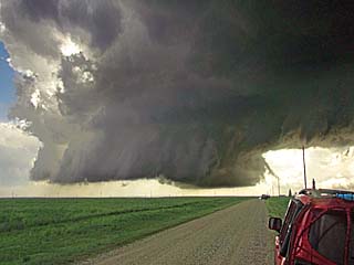
|
Large rotating wall cloud as the supercell storm moves eastward from Platte County and into Goshen County north of SR 313. The view is to the west and southwest. |
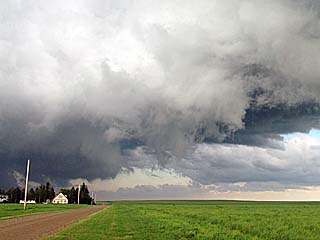
|
Rapid rotation with powerful, warm RFD / downward cascading motion in the foreground, looking eastward from near Canyon View Ranch. A very brief tornado is occurring here (center of photo), although weak, some ground circulation was confirmed (but I cannot see it here from this vantage point). To the far left, the new mesocyclone is forming. |
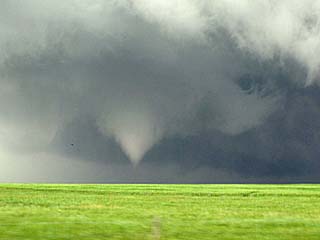
|
Major tornado-genesis occurring north of SR 313 as second tornado begins forming. The view is to the north and northeast. |
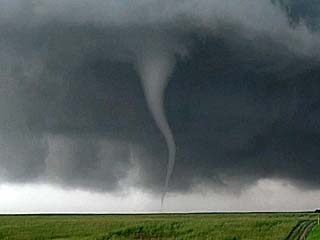
|
Beautiful second tornado looking north on a farm road north of SR 313 in Goshen County, Wyoming. This will rope out quickly and another "cycle" of the supercell will "hand-off" to a new mesocyclone to the east. |
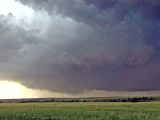
|
Brief third tornado (just left and below of photo center) east of where the second one occurred as the storm "cycles". |
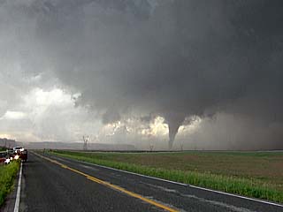
|
Wide view of a fourth tornado over Goshen County, Wyoming west of Hawk Springs and north of SR 313. The view is to the west and northwest. |
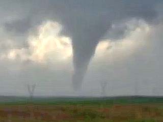
|
Close-up of the fourth tornado. The view is to the west and northwest. |
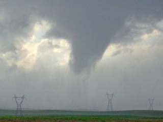
|
Fourth tornado dissipates and the cyclic supercell produces another mesocyclone northwest of La Grange to the east. |
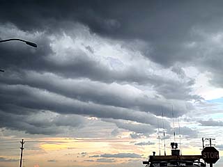
|
View looking up at multiple HCRs (horizontal convective rolls) to the southeast of the supercell as the low-level jet increases during the evening. |
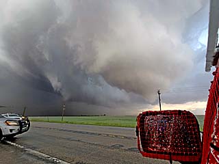
|
Fifth tornado developing in an area of strong rotation and destructive inflow / RFD winds along Highway 85, north of La Grange / near Hawk Springs as storm cycles up again. A developing large tornado can be seen to the right of the center of the photo. The view is to the east and northeast. |
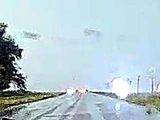
|
Frame grab from dash-cam looking north on Highway 85 near Hawk Springs. Power lines are blowing down in a strong rear-inflow jet into the developing tornado, with power flashes as debris flies off the trees to the left. |
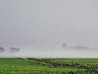
|
Intense ground circulation and dust / spray kicked up off the prairie as the core-flow of the developing fifth tornado intensifies. The view is to the east and northeast. |
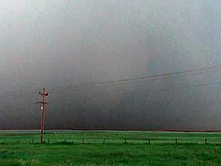
|
Poor contrast looking northeast from Highway 85 as a large tornado (center of the picture) clearly forms. The view is to the northeast. |
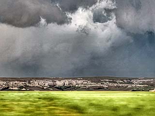
|
View of large (fifth) tornado still in progress and partially rain-wrapped looking north and northwest from SR 151 east of La Grange, Wyoming. |
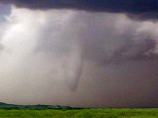
|
Fifth tornado fully occludes and begins thinning out with a cigar shape. The view is to the northwest from just east of the WY / NE border on CR 7. |
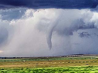
|
Fifth tornado finally ropes out with a long cigar shape just before that, after being on the ground for a half hour! The view is to the northwest from CR 7 in Scotts Bluff County, Nebraska. |
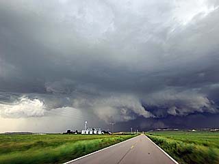
|
New mesocyclone, with possible rain-wrapped brief sixth tornado (not visible) under it. The view is to the north from along CR 7 and southwest of Scotts Bluff, Nebraska. The old mesocyclone, responsible for the fifth tornado, is to the left left. |
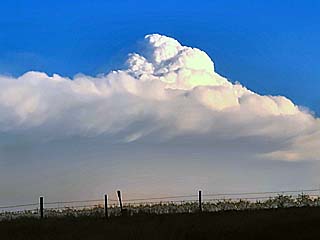
|
View of over-shooting top (punching to nearly 60,000 feet into the stratosphere) of an un-related supercell well to the south from a distance while heading eastward along SR 88. |
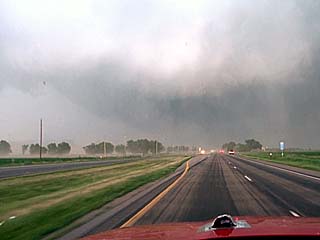
|
Heading up SR 71 towards Scotts Bluff, Nebraska, the intense RFD after the former tornado(s) increases with strong winds from left to right (and lots of blowing dust), and RFD clear slot overhead. The view is to the north. |
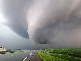
|
The cyclic supercell storm intensifies again with strong rotation on the south to southeast side of Scotts Bluff, Nebraska. The rear structure of the rapid rotation of the supercell wall cloud was amazing here. A developing tornado (probably the sixth or seventh one this storm produced) is off frame to the right. Note the large hail in the road. The view is north and northeast from SR 71. |
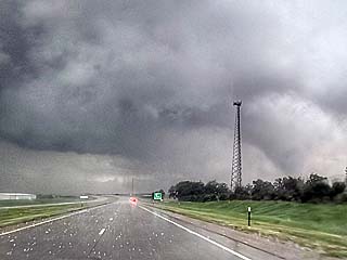
|
View of sixth (or seventh) tornado to the right side of this picture. The view is northeast from between Scotts Bluff and Gering along SR 71. |
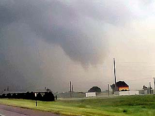
|
Close-up view of the Scotts Bluff cone tornado. The view is to the northeast. |
|
Mid level vortex / funnel high up in the RFD region of the supercell storm between Gering and Northport, Nebraska. |
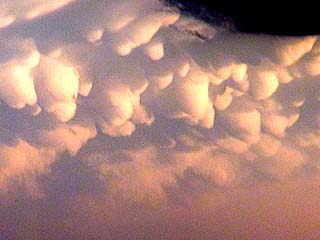
|
View of mammatus clouds associated with a powerful MCS well south of the area over NE Colorado and SW Nebraska. The view is to the south. |
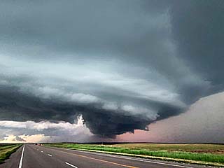
|
View of cyclic supercell storm from near SR 62A and Highway 385 north of Northport after dark. The view is to the northwest. Note the RFD and rotating wall cloud. |
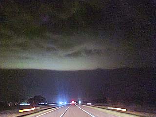
|
View of gust front leading edge heading out of the multi-cell MCS along I-80 eastbound well after dark. |
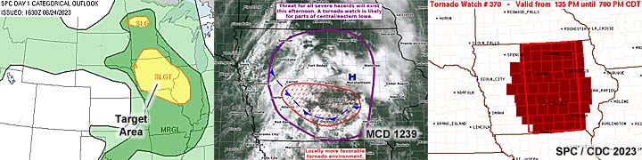
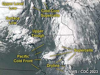
|
This an annotated visible satellite image at roughly 23z (late afternoon) on June 24, 2023 showing the synoptic environment. A large upper-level low is over the eastern Dakotas, with a trough extending south and east from there at high altitude. Various areas forming supercells, including southeastern Iowa, can be seen in this graphic. |
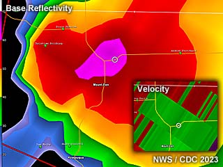
|
This is a radar image (base reflectivity) of a supercell storm over Van Buren County, Iowa (near Mount Zion / Birmingham) at around 6:30 PM CDT on June 23. Note my location (the white circle) inside the "purple" supercell core (at least 70 dBz) - Where I was experiencing severe winds and large hail (exceeding golf-ball sized) at the time. The subtle velocity is in the lower-right inset. |
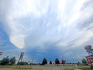
|
Convective initiation to the southeast of Des Moines, Iowa as high anvil blow-off spreads overhead looking south from near Altoona during the early afternoon of June 24. |
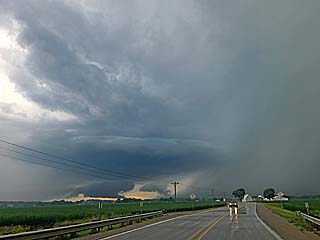
|
Supercell storm developing near Oskaloosa, Iowa. The view is to the west in Mahaska County. |
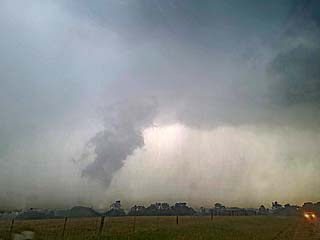
|
Brief funnel / rotating scud with a supercell storm northwest of Ottumwa, Iowa. The view is to the northwest. |
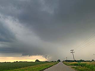
|
Intense hail core and supercell updraft base near near Mount Zion / Birmingham. The view is west and northwest. |
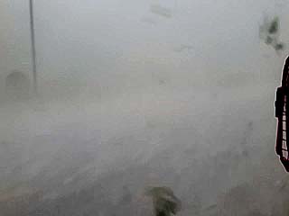
|
Strong winds and hail (note tree debris flying by) in the supercell core near near Mount Zion / Birmingham. |
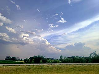
|
View of weakening storm looking southeastwards from near Mount Pleasant, Iowa during the late afternoon. |

|
Crowd gathers during a parade during the weekend of June 25 in downtown Chicago. |
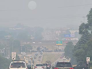
|
Canadian wildfires and smoke blowing across the Chicago area during the week of June 26 caused extensive haze and bad visibility. |

|
View of sun through the haze, with a large sunspot. The Canadian smoke allowed easy viewing of the sun, especially in the afternoon. |
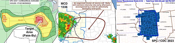
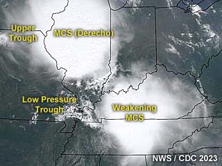
|
This an annotated visible satellite image at roughly 18z (noon to early afternoon) on June 29, 2023 showing the synoptic environment. A destructive derecho (straight-line wind damage) is occurring with a powerful MCS and cool pool pushing across Illinois. |
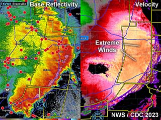
|
This is a radar image (base reflectivity to the left panel) of a powerful MCS and derecho pushing into central and eastern Illinois during the early afternoon of June 29, at about 1:30 PM CDT. The right panel shows the Doppler velocity (winds) associated with this extreme / damaging wind event, with gusts near 100 MPH in some places. |
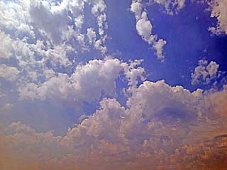
|
Altocumulus castellanus clouds drift overhead through a hazy sky over northern to central Illinois during the late morning of June 29. |
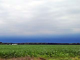
|
First view looking west of I-57 in east-central Illinois at the approaching derecho (dark band on horizon) rapidly approaching from the west. I tried hard to stay well ahead of this complex. |
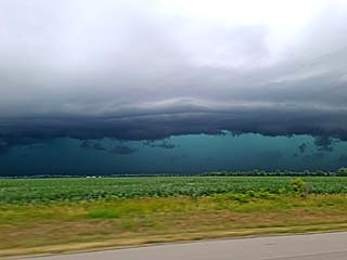
|
Leading edge of MCS / derecho draws closer. Does not look like much, but this system had winds gusting from 80 to 100 MPH at times east of Springfield, Illinois. The view is to the west. |
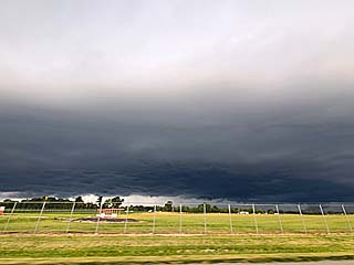
|
Tail-end storm near Mount Vernon, Illinois as its getting undercut by outflow. The view is to the north. |
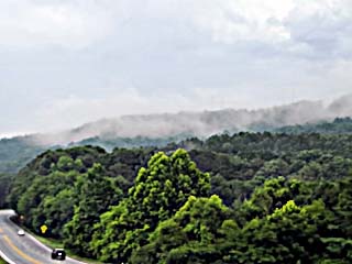
|
Passing through the southern Appalachian Mountains on June 30 south of Chattanooga, Tennessee. |
|
Passing through heavy traffic in downtown Atlanta during the afternoon of June 30. |
|
A "garden variety" (and completely harmless, compared to their stronger cousins in the central USA) thunderstorm in south Florida on July 1 while returning to Broward County. |
HTML File "mwcl2023.htm" - Developed By Chris Collura
To Return To The HOME Page Of This Site Click The "INDEX.HTM" Link Here!