
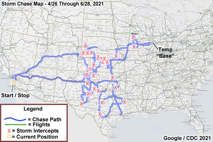
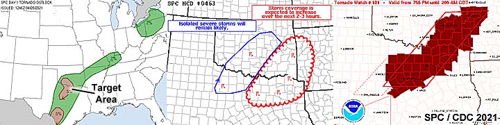
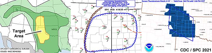
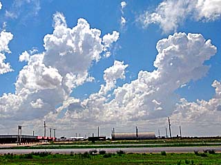
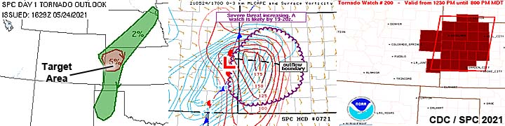
| This section is for storm chases done in the central / Midwestern United States during the year of 2021. This includes all storm chasing activities (including any major chase "expeditions") during the year of 2021 in the central USA (aka "Tornado Alley"). For 2021, all chases in the central USA will be logged in this section, with many of the chases being possible "spot" chases / major severe weather "setups" chased. Here you should find many pictures of lightning, tornadoes, hail, strong winds, along with many severe thunderstorm elements. Keep in mind that this chase log is scientific evidence and portrays my on-going storm chasing research. It has been placed on this page for easy reference and meteorological interests. Please do not plagiarize or copy this document to other sites for distribution. Note - This page may take a while to load on some SLOWER connections! |
STORM CHASING - CENTRAL UNITED STATES - 2021 CHASE LOG
| CHASER NAME | HOME / BASE CITY | CALLSIGN | CHASE DATES | OCCUPATION |
| CHRIS COLLURA | GARDEN GROVE, CA | KG4PJN | 4/24 TO 6/28 | IT CONSULTANT |
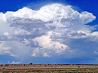
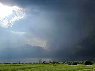
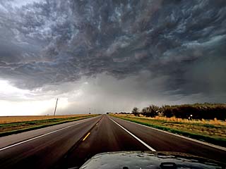
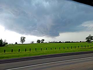
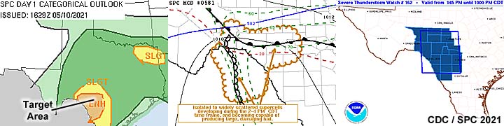
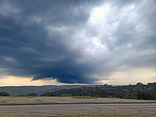
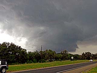
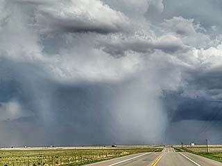
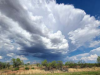
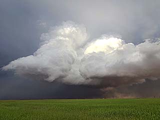
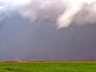
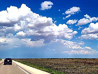
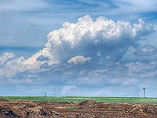
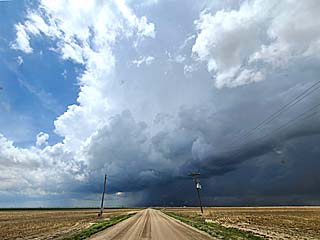
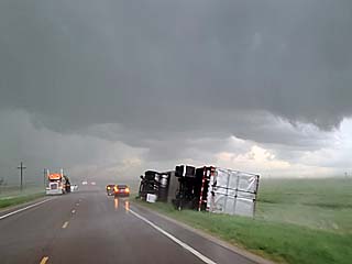
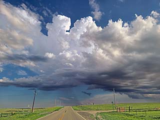
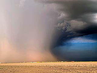
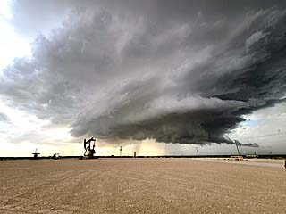
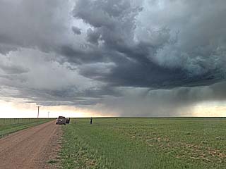
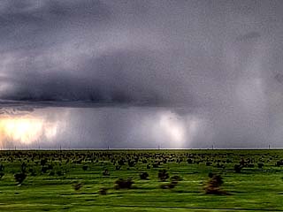
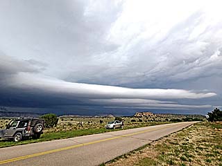
1). Apr 27, 4:00 PM - Interception, observation, and penetration of an extremely severe and tornadic thunderstorm from King County, Texas near Guthrie, and eastward into Knox County and north of Seymour on Highways 83, 82, and 183. The storm was a powerful classic / HP supercell storm. This storm produced a partially rain wrapped tornado as well, and was observed from a distance in low-contrast looking north from along Highway 82. This tornado appeared as a "bowl shaped" lowering with barely visible condensation areas under it. Contrast was poor from my vantage point but this tornado was confirmed. The storm also had a striking visual (striated) appearance at times and rock-hard "cauliflower" updraft column. Very large hail was also encountered with this storm on Highway 83 north of Guthrie, with isolated pieces as large as baseballs, and copious amounts of golfball-sized hail covering the ground. The storm also had frequent lightning, heavy rains, and 60 MPH winds. The hail caused some damage to vehicles. Conditions causing these storms were a dryline, surface heating, low pressure trough, and an upper trough. Documentation was digital stills and HD video. A 2016 Jeep Wrangler was used to chase the storms. A severe thunderstorm watch was also valid in the area until 9 PM CDT.
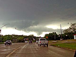
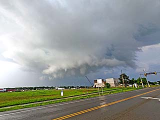
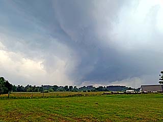
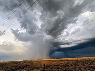
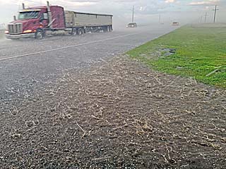
2). Apr 28, 6:00 PM - Interception, observation, and penetration of a very severe and possibly tornadic thunderstorm from near Goldsboro (south of Abilene) in Colemen County and near Highway 84, and northwestward through Cross Plains via SR 206, and eastward to near Rising Star along SR 36. The same storm was also abandoned and later intercepted from near Weatherford in Parker County along I-20 and into the NW side of Fort Worth near I-820 in Tarrant County. The storm was an HP supercell storm which intensified near Coleman County, weakened near Rising Star, and re-intensified, becoming tornado-warned, as it passed Weatherford and into Tarrant County near dark. An area of powerful RFD was observed after the storm was first intercepted near Goldsboro. A possible funnel was noted with the storm looking SR from SR 206 south of Cross Plains. Very large hail, up to baseball sized, was also encountered along I-820 as the storm entered Tarrant County northwest of Fort Worth. Frequent lightning, with some close hits, torrential rains, and winds over 70 MPH were also encountered. Flooding and hail damage was observed from this storm as well, with extensive hail damage done northwest of Fort Worth, with costs amounting in the billions of dollars! Conditions causing these storms were a surface heating, boundary interactions, a low pressure trough, and an upper trough. Documentation was digital stills, audio, and HD video. A 2016 Jeep Wrangler was used to chase the storms. A tornado watch was also valid in the area until 2 AM CDT the following day.
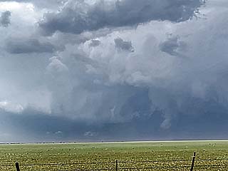
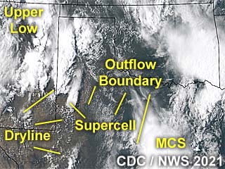
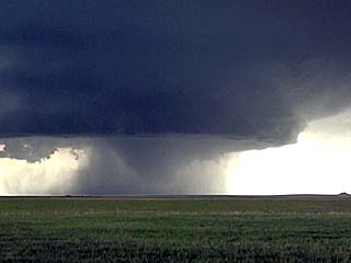
3). May 3, 6:00 PM - Observation and penetration of a very severe thunderstorm from near Ardmore in Carter County, Oklahoma near I-35 and Highway 70, and points northeastward to near Wapanucka near Highway 377 and SR 7 in Johnston County. The storm began as a classic supercell storm, evolving to HP, and eventually a bow-segment as it became involved in a cluster / MCS of strong and severe storms. The storm also had a wall cloud and brief funnel during its early life-cycle near Ardmore, and eventually evolved to a bow-segment near Wapanucka. The storm produced extremely heavy rains, frequent lightning (with some close hits), and winds over 60 MPH. Hail to golfball sized was observed north of Tishomingo as the core of the storm was penetrated, with a rain-free area of rotation briefly ocurring before the storm became outflow dominant. Conditions causing the storms were a slow-moving cold front / dryline intersection, low pressure area, surface heating, and an upper trough. Documentation was digital stills and HD video. A 2016 Jeep Wrangler was used to chase the storms. A tornado watch was also valid in the area until 11 PM CDT.
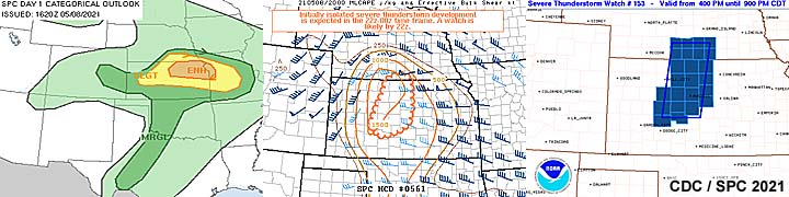
4). May 8, 7:00 PM - Observation and penetration of severe thunderstorms from near Lacross in Rush County, Kansas, near Highways 183 and 281, and points eastward along I-70 into Salina in Saline County. The thunderstorms began as a cluster of small supercells, mostly in LP mode, and organized into a cluster of storms, with once cell evolving to HP mode, and ultimately a powerful bow segment near Salina. During this chase, frequent lightning (with some close hits), torrential rains, hail to 1", and winds gusting over 70 MPH. Some flooding was also observed. The storms were caused by surface heating, a low pressure area / frontal zone, dryline, and an upper trough. Documentation was digital stills, HD video, and audio. A 2016 Jeep Wrangler was used to chase the storms. A severe thunderstorm, and tornado watch was also valid in the area until 9 PM CDT, and 1 AM CDT the next day, respectively.
5). May 9, 4:30 PM - Observation and penetration of a severe thunderstorm near Jacksonville, Texas in Cherokee County, and near Highways 69 and 79. The storm was a small classic to HP supercell that developed within a large area of showers and thunderstorms. Conditions observed were frequent lightning, hail up to 1", 60 MPH winds, and torrential rains. A rotating wall cloud was observed with this storm, before it was under-cut by the RFD / outflow. Flooding and some tree damage was also observed. Conditions causing the storm were pre-frontal convergence, surface heating, low pressure trough, and an upper trough. Documentation was digital stills and audio. A 2016 Jeep Wrangler was used to chase the storms. A severe thunderstorm watch was also valid in the area until 9 PM CDT.
6). May 10, 4:30 PM - Interception and observation of a severe thunderstorm in Real County, Texas to the north of Leakey and near Highway 83. The storm was a classic supercell storm. A large, rotating wall cloud was noted on the SW side of the storm. The storm core was not directly penetrated. Conditions observed were 40 MPH winds (mainly RFD), frequent lightning, light rain, and hail up to nickel sized (while near the edge of the storm core). The storm underwent downscaling after passing northeast of Leakey and near Bandera, where it completely dissipated. Conditions causing the storm were surface heating, low pressure trough, frontal boundary, and an upper trough. Documentation was digital stills and HD video. A 2016 Jeep Wrangler was used to chase the storms. A severe thunderstorm watch was also valid in the area until 10 PM CDT.
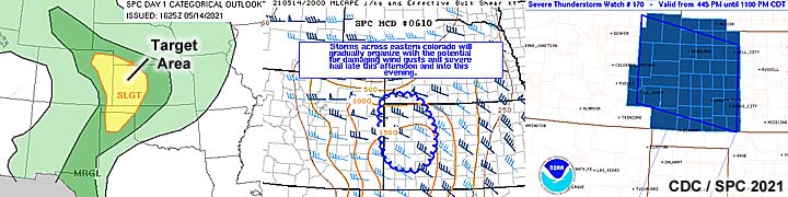
7). May 14, 8:00 PM - Observation and penetration of an extremely severe thunderstorm from near Highway 24 between Hoxie and Hill City, Kansas in Graham County and southward along Highway 281 into Trego County near Wakeeney. The storm was a classic supercell that was observed from its point of initiation, and evolved to HP as it passed over Wakeeney after dark. The storm had a very striking visual appearance, with the "mothership" look at times. A rotating wall cloud, with some funnels, and even a possible weak tornado, was also observed. The core of the storm was penetrated, and copious amounts of hail, at least 2", was seen covering the ground. I took a crack on my windshield before I was able to scurry and get the front hail shields on. The storm also contained 60 MPH winds, frequent lightning, and very heavy rains. The hail reported in Wakeeney was up to grapefruit sized (4 inches)! Conditions causing these storms were a stationary / warm frontal boundary, surface heating, a low pressure trough, and an upper trough (in cold, NW flow aloft). Documentation was digital stills, audio, and HD video. A 2016 Jeep Wrangler was used to chase the storms. A severe thunderstorm watch was also valid in the area until 11 PM CDT.
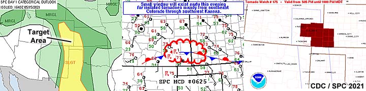
8). May 15, 7:00 PM - Interception of severe thunderstorms from near Campo, Colorado and Highway 385 in Baca County, and points northeastward to near Manter, Kansas in Stanton County near Highway 160. The storms were on a northern portion of a line segment that was interacting with a stalled frontal boundary, with a supercell storm observed near Saunders. Conditions encountered were 1" hail, frequent lightning with some close hits, and heavy rains. A funnel was observed from a distance with the weakening supercell from a distance, looking west from north of Manter, Kansas. Although un-related to the storms, myself and some other storm chasers stopped to assist a single motorist in a totaled sports car north of Manter. The person was shaken but OK, and he apparently hit a pregnant female deer that darted out into the road in front of him. Conditions causing the storm were surface heating, up-slope wind flow, a low pressure trough and stalled frontal boundary well ahead of an upper trough. Documentation was digital stills and HD video. A 2016 Jeep Wrangler was used to chase the storms. A tornado watch was also valid in the area until 10 PM CDT.
9). May 16, 6:30 PM - Observation and indirect penetration of a very severe thunderstorm to the southwest of Vega, Texas and west of Highway 385 in Deaf Smith County. The storm started as an LP supercell storm, that evolved to classic mode, while remaining nearly stationary west of Highway 385. The storm produced golfball sized hail, heavy rains, 60 MPH winds. A rotating area was noted before the storm down-scaled, with some small funnels observed. Conditions causing these storms were a stationary frontal boundary, surface heating, a low pressure trough, and a dryline. Documentation was digital stills, audio, and HD video. A 2016 Jeep Wrangler was used to chase the storms. A severe thunderstorm watch was also valid in the area until 11 PM CDT.
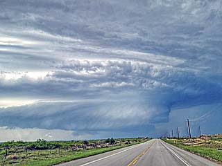
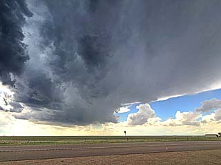
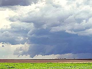
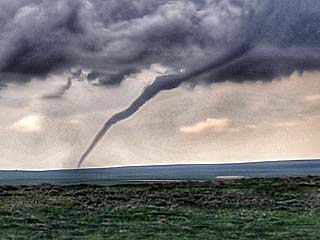
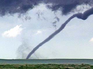
10). May 17, 7:30 PM - Observation and indirect penetration of a very severe and tornadic thunderstorm from near Sundown, Texas in Hockley County and eastward to its demise near Lubbock, Texas and I-27 / FM-1585. The storm was an LP to classic supercell storm. Two weak tornadoes were observed with this storm between Levelland and Wolforth, pretty much near and along FM-1585. The storm down-scaled when it reached the south side of Lubbock. The tornadoes were over open fields, and did no damage, but one was observed at very close range - With a rapidly rotating dust swirl beneath the funnel, with large hail flying around it. The storm core was not directly penetrated, but hail to golfball sized was observed. The storm had a striking visual appearance, and dust / low visibility was noted in the RFD areas and storm inflow. Lightning, moderate rains, and winds near 70 MPH (mainly RFD) were also encountered. The supercell storm also had a striking visual appearance, with a "stacked plates" presentation. Large amounts of dust were kicked up by the storm inflow (and RFD winds). Conditions causing these storms were surface heating, outflow boundary / dryline interactions, a low pressure trough, and an upper low / trough. Documentation was digital stills and HD video. A 2016 Jeep Wrangler was used to chase the storms. A tornado watch was also valid in the area until 11 PM CDT.
11). May 18, 7:30 PM - Interception, observation, and indirect penetration of a very severe and tornadic thunderstorm in Dawson County, Texas near LaMesa and eastward along and near Highways 87 and 180. The storm was a classic supercell storm that eventually evolved to a bow segment near dark. Two small and brief tornadoes were observed with this storm, with a well developed RFD and blowing dust in many areas. The weak tornadoes were not fully condensed, with a dust swirl under a funnel at cloud base. The storm also contained hail to tennis ball sized, and the core was indirectly penetrated (and during weakening phases of the storm). Copious amounts of marble sized hail were noted covering the ground. One stone exceeding 2" was seen falling near the updraft-downdraft interface of the storm. The storm also contained very heavy rains, lightning, and winds over 60 MPH. Conditions causing these storms were surface heating, outflow boundary / dryline interactions, a low pressure trough, and an upper low / trough. Documentation was digital stills, audio, and HD video. A 2016 Jeep Wrangler was used to chase the storms.
12). May 20, 5:00 PM - Observation and indirect penetration of a strong to severe thunderstorm in Washington County, Colorado from near Highway 36, and north on SR 71 to near Brush, and near Highway 34 / I-76. The storm began as an LP supercell storm, eventually down-scaling to almost nothing, then re-generating north of I-76 and into Weld and Logan Counties, where baseball sized hail was reported near dusk. This storm had a striking visual appearance during its early stages, and a high base later on when it regenerated to the north (as a powerful hail storm). The core was not penetrated. Conditions encountered were small hail, some lightning, moderate rain, and winds gusting near 60 MPH. Conditions causing these storms were surface heating, up-slope wind flow, a low pressure trough, and an approaching upper low / trough. Documentation was digital stills and HD video (time-lapse). A 2016 Jeep Wrangler was used to chase the storms.
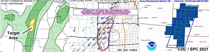
13). May 21, 7:00 PM - Observation of strong and severe thunderstorms from west of SR 113 and Highway 385 to the north of Sterling (in Logan County, Colorado) and west of Bridgeport, Nebraska (in Scottsbluff County, Nebraska). The storms were a struggling cluster of strong and severe storms, with once cell observed as a low-precipitation supercell storm before storms weakened and remained "messy". The cores were not penetrated, in an environment of strong southerly winds and light rain at times. Lightning was also observed. The storms weakened due to meridonal flow aloft (S winds at high altitude and same direction near the ground / low levels). Conditions causing these storms were surface heating, up-slope wind flow, a low pressure area, dryline / cold front interactions, and an approaching upper low / trough. Documentation was digital stills. A 2016 Jeep Wrangler was used to chase the storms. A severe thunderstorm watch was in effect for the area until 10 PM MDT.
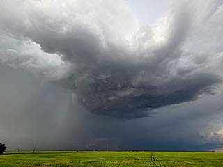
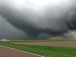
14). May 22, 2:00 PM - Interception, indirect penetration, and observation of a very severe thunderstorm in Morgan County, Colorado from south and southwest of Brush and Akron, and northeastward to near Fleming via Highway 34 and SR 63. The storm began as a classic supercell storm, that developed in an unusual location on the northwest side of a cluster of strong and severe storms. This powerful supercell eventually merged with the cluster of storms, and this MCS continued northeastward and eventually weakened. This supercell produced 3 tornadoes when it was south of Brush, viewed from a couple miles away. One tornado was an impressive elephant trunk tornado, and the other two were funnels with a ground swirl observed under them. The supercell had an impressive visual appearance, with numerous funnels and a wall cloud, and defined RFD clear slot. The core of this storm was not penetrated during maximum intensity. No damage was observed as the tornadoes were over rural country. Winds near 60 MPH, very heavy rains, lightning, and hail to 1" was encountered, mainly during the MCS stage of the storm. Conditions causing this storms was surface heating, up-slope wind flow, a low pressure area, stalled cold front boundary, and an upper low / trough. Documentation was digital stills, audio, and HD video. A 2016 Jeep Wrangler was used to chase the storms. A tornado watch was in effect for the area until 8 PM MDT.
15). May 23, 3:00 PM - Interception, observation, and indirect penetration of a very severe and tornadic thunderstorm, mainly in Washington County, Colorado from near Anton and past Akron and to the southeast of Sterling, from Highway 36 and northward, west of SR 59, and to near Highway 6. The storm was a powerful HP supercell storm, and a cone tornado was observed from dirt roads while caravanning with other storm chasers in Washington County (between Anton and Akron). The storm continued rapidly to the NNE, with striking HP appearance at times, with well-defined RFD and wall clouds with funnels. A brief glimpse of a large, rain wrapped tornado, was also observed to the SE of Sterling near Fleming. Other conditions encountered were 60 MPH winds, frequent lightning, and hail to 1" as the core was grazed near Anton. The dangerous parts of this thunderstorm remained over open fields and in rural areas. No damage was observed. The storm was caused by surface heating, up-slope wind flow, a dryline, low pressure area, and an upper trough. Documentation was digital stills, audio, and HD video. A 2016 Jeep Wrangler was used to chase the storm. A tornado watch was in effect for the area until 8 PM MDT.
16). May 23, 6:00 PM - Penetration of a severe thunderstorm near Yuma, Colorado along Highway 34, and eastward to near Wray, and north on Highway 385 in Yuma County. The storm was a small supercell storm, embedded in a line segment of strong and severe storms. Rotation, with a wall cloud and funnels, was noted as the storm passed rapidly northeastwards. Conditions encountered were small hail, lightning, and winds gusting briefly over 70 MPH. The storm was caused by surface heating, up-slope wind flow, a dryline / outflow interactions, low pressure area, and an upper trough. Documentation was digital stills, audio, and HD video. A 2016 Jeep Wrangler was used to chase the storm. A tornado watch was in effect for the area until 8 PM MDT.
17). May 23, 8:00 PM - Indirect penetration of a severe thunderstorm to the east of Wray, Colorado (Yuma County), along Highway 34, and into Dundy County, Nebraska near Benkelman. The storm was a northern storm associated with a bowing MCS, with some high-precipitation supercell characteristics. When the north side of this storm was encountered, 60 MPH winds, lightning, and hail penny to nickel sized was encountered. The storm had a striking visual appearance when viewed from the east, back-lit by the setting sun, and "green" hail core. The storm was caused by surface heating, an outflow boundary, low pressure area, and an upper trough. Documentation was digital stills, audio, and HD video. A 2016 Jeep Wrangler was used to chase the storm. A tornado watch was in effect for the area, and expiring at 8 PM MDT.
18). May 24, 3:00 PM - Observation and indirect penetration of a very severe thunderstorm north and northwest of Leoti, Kansas in Wichita County and near SR 25. The storm was a classic to HP supercell storm, that eventually evolved to a line segment. The storm had a wall cloud and produced some small brief funnels. I abandoned the storm due to better storms to the north and poor road networks near Leoti. Conditions observed were 60 MPH winds, heavy rains, lightning, and hail to about 1". The storm was caused by surface heating, a dryline / Pacific cold front, low pressure trough, and an upper trough. Documentation was digital stills and HD video. A 2016 Jeep Wrangler was used to chase the storm. A tornado watch was in effect for the area until 9 PM CDT.
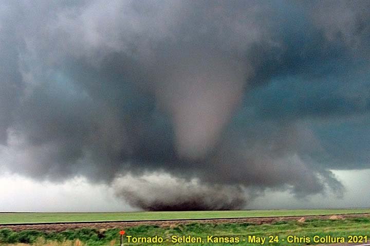
19). May 24, 5:30 PM - Interception, observation, and penetration of an extremely severe and potentially violent tornadic thunderstorm from northeast of Colby in Thomas County and eastward to near Seldon, Kansas in Sheridan County, pretty much along Highway 83. The storm was a classic cyclic supercell storm (HP at times). Tornadoes were first observed with this storm from afar, looking north out of Russell Springs while approaching what was two supercells early in the life-cycle (storm split). The eastern supercell would be the most violent of the two, especially when it began interacting with the east-to-west oriented frontal boundary east of the surface low, just as the low level jet was intensifying in the evening. After producing small tornadoes and funnels, the storm evolved to HP near Rexford, then rapidly intensified east of there, producing a large and destructive tornado. Seldon took a direct hit from this storm, with significant damage to homes / businesses, powerlines down, and semi-trucks overturned. The supercell itself had a striking visual appearance, and the large tornado was observed at very close range. The storm got east of Sheldon after turning right and eventually down-scaled to a small classic / LP storm (still wit small funnels) and dissipated near northeastern Sheridan County. The storm also contained frequent lightning with some close hits, torrential rain, baseball sized hail (the core was not directly penetrated, so I saw hail briefly to 2"). Winds, mainly RFD, gusted over 100 MPH on the backside of the storm near Sheldon. The storm was caused by surface heating, a dryline / Pacific cold front and outflow boundary interactions, low pressure area, and an upper trough. Documentation was digital stills, audio, and HD video. A 2016 Jeep Wrangler was used to chase the storm. A tornado watch was in effect for the area until 9 PM CDT.
20). May 25, 8:30 PM - Observation and penetration of very severe thunderstorms between Booker, Perryton, and Spearman, Texas in Ochiltree County, pretty much along SR 15. The storms were a cluster of thunderstorm which evolved to a cluster of supercells (mainly classic to HP in nature). Conditions observed were 60 MPH winds, hail to 1", frequent lightning, and heavy rains. Once of these supercells produced baseball sized hail, but the core was not directly penetrated. Hail was noted covering the ground near Perryton, Texas. A funnel cloud was also observed on one of the supercells over Perryton, with a well-defined RFD slot. The storms were caused by surface heating, a dryline / outflow boundary interaction, and weak low pressure area. Winds aloft were from the northwest. Documentation was digital stills, audio, and HD video (including time-lapse). A 2016 Jeep Wrangler was used to chase the storm. A severe thunderstorm watch was in effect for the area until 11 PM CDT.
21). May 26, 9:00 PM - Interception, observation, and indirect penetration of a severe and tornadic thunderstorm south of Hill City, Kansas in Graham County and near and along Highway 283. The storm was an HP to classic supercell storm developing on the southern end of a cluster of strong and severe storms. This storm had a striking visual appearance, with a "mother-ship" appearance, and well defined RFD clear area, with rapid cloud motions. A brief tornado, fully condensed, was observed in an open field with this storm. No damage was done. The storm also contained 1" hail, moderate rains, frequent lightning, and 60 MPH winds. The storm was caused by surface heating, frontal boundary, low pressure trough, and an upper trough. Documentation was digital stills and HD video. A 2016 Jeep Wrangler was used to chase the storm. A PDS (particularly danerous situation) tornado watch was in effect for the area until 2 AM CDT the following day.
22). May 27, 1:30 PM - Interception and observation of a severe thunderstorm just north of Mulhall and east of I-35 in Payne County, Oklahoma. The storm was a small supercell storm, classic to HP in nature, on the leading edge of a cluster of strong and severe storms. A rotating wall cloud and brief funnel was observed with this storm. The core was not penetrated, with moderate rain, small hail, lightning, and 40 MPH winds encountered. Arrival to the storm was hindered south on I-35 near Orlando due to construction traffic. The storms were caused by surface heating, outflow boundary, low pressure trough, and upper trough. Documentation was digital stills and HD video. A 2016 Jeep Wrangler was used to chase the storm. A tornado watch was in effect for the area until 7 PM CDT.
23). May 27, 7:00 PM - Interception, observation, and penetration of a severe thunderstorm in Hall County, Texas near Turkey and along SR 70. The storm was an LP supercell with a high base, producing a lot of hail, with a storm split observed (the southern split turned right and moved southeast, as the left split moved northeast). Conditions encountered were hail ping-pong to isolated golf ball sized hail, covering the ground near Turkey. The storm also had 45 MPH winds and moderate rain. Lightning was also observed with this storm. The storm was caused by surface heating, a dryline, low pressure trough, and upper trough. Documentation was digital stills and HD video (including time-lapse). A 2016 Jeep Wrangler was used to chase the storm. A severe thunderstorm watch was in effect for the area until 11 PM CDT.
24). May 28, 8:00 PM - Interception, observation, and penetration of an extremely severe thunderstorm in Ward County, Texas near Pecos and Pyote and near I-20 and Ranch 2355. The storm was an LP to classic supercell, producing very large hail, moving southeasterly across Ward County. Conditions encountered were hail falling up golf ball sized hail, covering the ground, with some isolated pieces near baseball sized along I-20 east of Pecos. The storm also had a striking visual appearance (striations). A rotating wall cloud was also observed under the storm base, with well developed RFD. Winds around 60 MPH, frequent lightning, and heavy rain was also observed. The storm was part of a cluster of supercells, being the more intense one, and was caused by surface heating, up-slope wind flow, and stalled frontal boundary, low pressure trough, and upper trough. Documentation was digital stills, audio, and HD video (including time-lapse). A 2016 Jeep Wrangler was used to chase the storm. A severe thunderstorm watch was in effect for the area until 11 PM CDT.
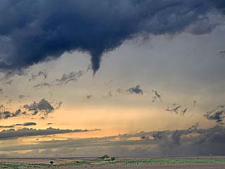
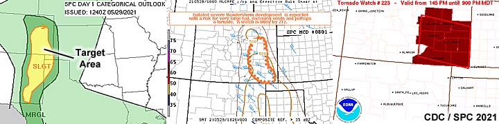
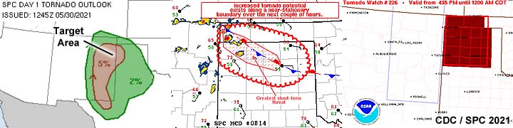
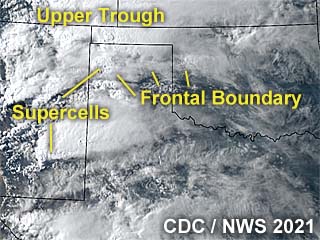
25). May 29, 6:30 PM - Observation of an extremely severe and tornadic thunderstorm from Las Animas and Baca Counties in southeastern Colorado near Pritchett and along Highway 160, and southeastward into NW Oklahoma near SR 325 in the Black Mesa Park and to the northwest of Boise City in Cimarron County, Oklahoma. The storm was a powerful, and potentially violent, cyclic supercell moving slowly southeast from its point of initiation in SE Colorado and into the extreme NW Oklahoma Panhandle. This storm began as a transient supercell in a small MCS of storms during the early afternoon. A small land-spout was noted after storm initiation (when bases were high) and brief tornado as the storm began intensifying as it moved southeast past Pritchett. As the storm intensified farther by early evening, a large cone tornado, albeit rain wrapped, was noted looking west from CR 13 / country roads. This tornado remained over rural areas and no damage was noted, and was viewed from a range of about 5 miles. This storm had a striking visual appearance as well, with multi-layered "tiers" and striations, impressive inflow tails, and a powerful RFD. The core was not penetrated, and had heavy rain and hail nearly 3" in diameter, especially as it entered the NW Oklahoma Panhandle near Black Mesa Park. Frequent lightning and at least 50 MPH inflow winds were noted with this storm as well. After dark, the storm remained in HP mode, and at least one large tornado was observed, illuminated by lightning, looking north from SR 325 west of Boise City, Oklahoma. This final tornado was a large wedge tornado, and at one point another large cone tornado (probably a satellite) was noted orbiting around this wedge tornado! Again - and very fortunately - this tornado missed any populated areas. The storm weakened via down-scaling by roughly 10:30 PM, CDT north of Boise City. The storm was caused by surface heating, up-slope wind flow, low pressure area, and upper trough. Documentation was digital stills and HD video (including time-lapse). A 2016 Jeep Wrangler was used to chase the storm. A tornado watch was in effect for the area until 9 PM CDT.
26). May 30, 5:30 PM - Interception, observation, and penetration of an extremely severe and tornadic thunderstorm near Felt and Boise City, Oklahoma, and near Highways 54 and 287, in Cimarron County. The storm was a cyclic HP supercell, and arrived on late from a long diversion into New Mexico earlier. The storm produced several tornadoes, ranging from small cones to almost a wedge. Three of these were seen in very low contrast conditions as rain wrap was common. The core of the storm, containing baseball sized hail, or larger, was not directly penetrated. Hail was noted covering the ground and roadway between Felt and Boise City. The largest hail encountered was just over 1", with 60 to 70 MPH winds, torrential rains, and lightning. The storm also had a well developed RFD, with rapid cloud motion, funnels, and even hail fog being pulled off the ground and back into the storm. Severe flooding also occurred with this storm. After weakening, another potentially tornadic supercell formed farther southeast into Texas near Stratford, but bad decisions caused me to miss most of that one. Conditions causing these storms were surface heating, up-slope wind flow, a stalled frontal boundary, low pressure trough, and an upper trough. Documentation was digital stills and HD video. A 2016 Jeep Wrangler was used to chase the storm. A tornado watch was in effect for the area until 12 AM CDT the following day.
27). June 20, 5:00 PM - Interception and penetration of a strong to severe thunderstorm in Bremer County, Iowa along SR 188 and Highway 218 and through Plainfield. The storm was an outflow dominant severe storm developing ahead of a cold front. Conditions encountered were 60 MPH winds, very heavy rains, small hail, and occasional lightning. The storm weakened as it became outflow dominant and more storms developed farther south. Conditions causing this storm was surface heating, cold front, low pressure trough, and an upper trough. Documentation was digital stills. A 2016 Jeep Wrangler was used to chase the storm. A severe thunderstorm watch was in effect for the area until 9 PM CDT.
28). June 20, 7:00 PM - Interception, observation, and penetration of an extremely severe and tornadic thunderstorm from Makasha County, Iowa (east of Pella) near Highway 63 and SR 92, and eastward as far as Washington and SR 1 in Washington County. The storm was a tornadic supercell, mainly HP, with the late / dissipating stages of the tornado observed as the storm became outflow / RFD dominant and cycled down west of Sigourney. The storm was tracked east where it re-cycled and became tornado warned once again over Washington County. Numerous funnels were also observed, along with well developed RFD and a striking visual presentation of the supercell near dusk. The core of this storm was also penetrated, especially in Washington County. Hail to 2" in diameter was observed, along with torrential rains, frequent lightning, and winds gusting over 75 MPH. Flooding and tree damage was also observed. Conditions causing this storm was surface heating, cold front, low pressure trough, and an upper trough. Documentation was digital stills and HD video. A 2016 Jeep Wrangler was used to chase the storm. A severe thunderstorm watch was in effect for the area until 11 PM CDT.
29). June 24, 6:00 PM - Interception and observation of a very severe, and possibly tornadic thunderstorm near Marysville, Kansas in Marshall County, from near Highways 77 and 36, and eastward to near Seneca and SR 99. The storm was a classic to HP supercell storm, separated from "messier" severe storms farther north. The storm quickly intensified, and a large, rotating wall cloud, with RFD cut and inflow bands was observed north of Beatti. The storm came very close to producing a large tornado, with tagging rain curtains, before becoming outflow dominant. The core of this supercell, containing at least golfball sized hail, was not penetrated. Other conditions encountered were occasional lightning, heavy rains, and 60 to 70 MPH winds, mainly RFD. Conditions causing this storm was surface heating, stationary front, low pressure trough, and an upper trough. Documentation was digital stills and HD video. A 2016 Jeep Wrangler was used to chase the storm. A tornado watch was in effect for the area until 10 PM CDT.
30). June 25, 5:30 PM - Interception, observation, and penetration of very strong thunderstorms from near Abbyville west of Hutchinson, Kansas in Reno County and northward to Ellsworth County near Geneseo from Highway 50 and SR 14. The storm began as a small LP supercell storm, which split into two completely separate storms. The southern split weakened and the left (north) split continued northward rapidly, eventually reaching Rice and Ellsworth Counties. The core of the northern storm was penetrated, and 50 MPH winds, heavy rains, and hail to dime sized was encountered. Some lightning was also observed. Conditions causing these storms were surface heating, stationary boundary, weak low pressure trough, and an upper trough. Documentation was digital stills and HD video, mainly time-lapse of the storm split. A 2016 Jeep Wrangler was used to chase the storm. A severe thunderstorm watch was in effect for the area until 9 PM CDT.
This concludes the chase log for the central US Plains for the main chase "expedition" of 2021 starting on April 24 and ending on June 28, 2021. The summary includes a total of 30 observation(s), out of which there were 29 severe thunderstorms and 1 strong thunderstorm. Out of these thunderstorms, as many as 25 possible tornadoes were observed, some significant. A 2016 Jeep Wrangler vehicle was used in all of the chases / observations above, logging a total of 19,170 miles. All entries for the logs above are for the local time zone unless otherwise noted. This information was prepared exclusively for the National Weather service and the team of Skywarn storm spotters.
|
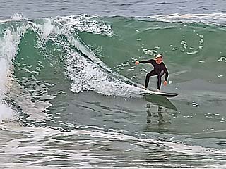
Just before heading out of southern California on April 24, 2021, I had a chance to see some big waves hitting Newport Beach (aka "the Wedge" break). This will be the last time I see the ocean in some time. |
|
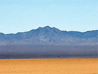
Just a few hours inland, I enter the Mojave Desert during the late morning of April 24. A far cry from the beachfront surfing towns in southern California. |
|
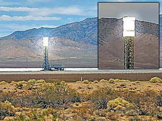
Passing the Ivanpah solar electric generating station off I-15 near the CA / NV border in the Mojave Desert. The inset shows one of the three towers under load. |
|
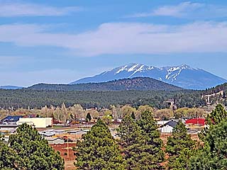
Mountains with snow / ski areas passing through Flagstaff, Arizona during the afternoon. |
|
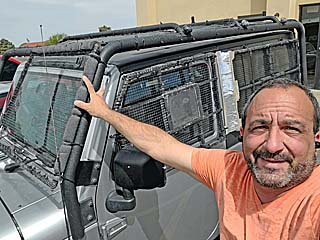
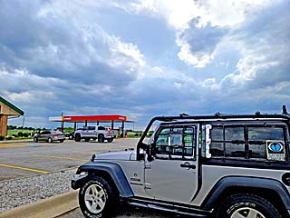
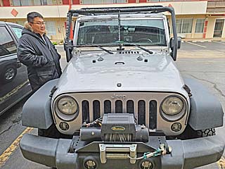
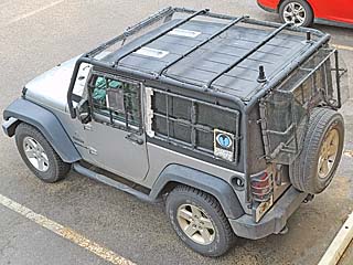
Myself preparing my vehicle (2016 Jeep Wrangler) for the up-coming chase during the afternoon of April 26. |
|
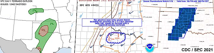
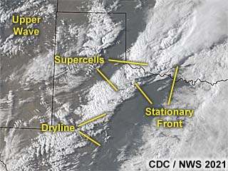
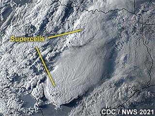
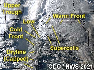
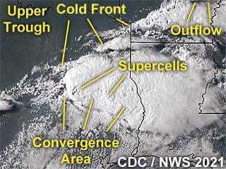
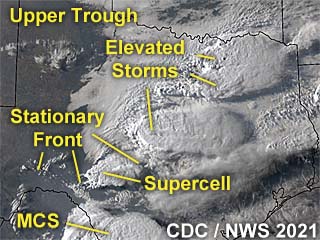
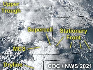
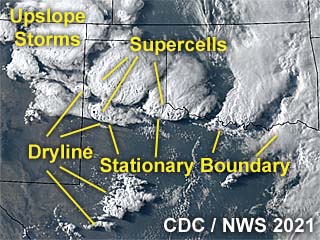
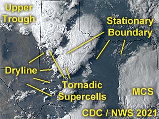
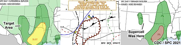
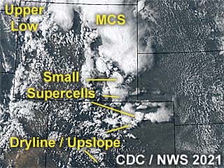
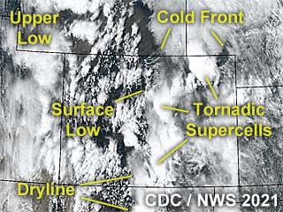
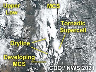
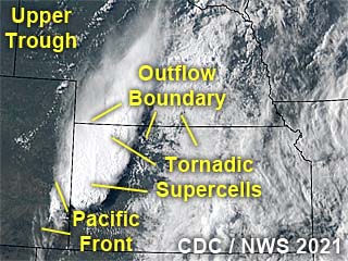
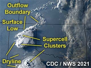
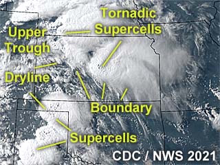
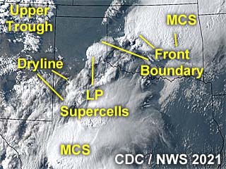
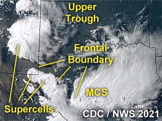
This is the annotated visible satellite image, showing the synoptic environment, from around 23z. Supercells, including a tornadic supercell storm in the target area, can be seen erupting in the SE Texas Panhandle, where a dryline and weak front intersect. The upper wave is approaching from the northwest, providing the necessary lift for robust convection. |
|
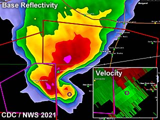
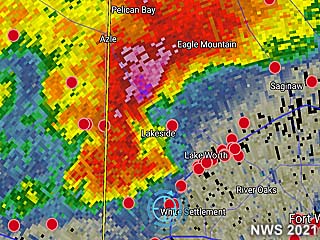
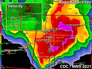
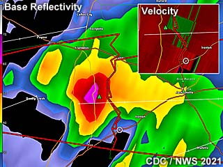
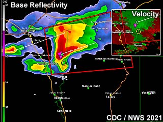
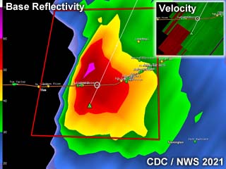
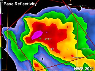
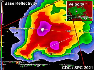
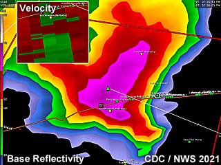
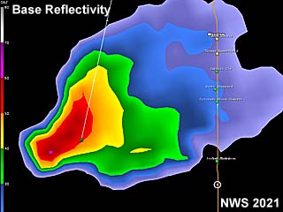
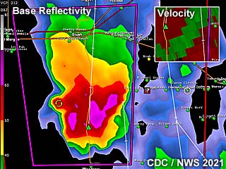
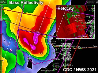
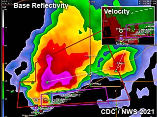
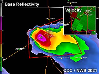
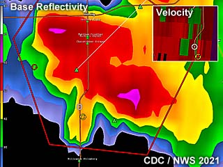
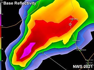
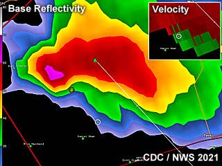
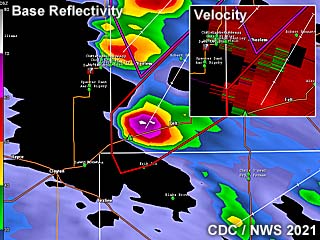
This is the radar image (base refletivity) of a tornadic supercell between Guthrie and northwest of Benjamin at roughly 4 PM CDT. The supercell has an impressive presentation on the radar reflectivity. The velocity, inset, shows the developing gate-to-gate shear developing with the storm. |
|
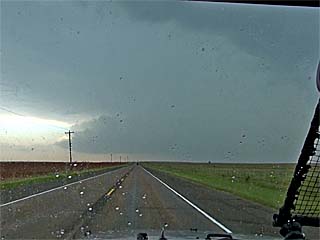
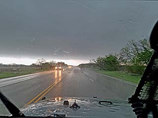
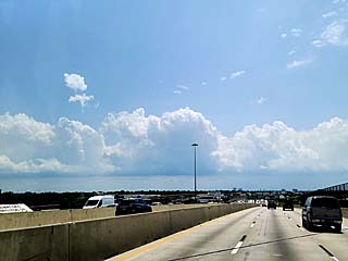
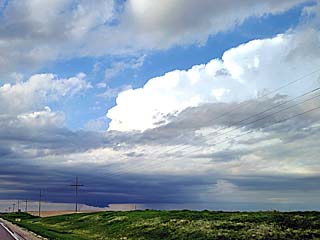
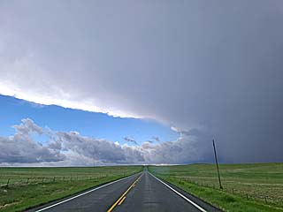
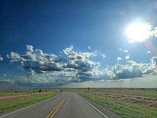
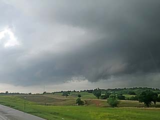
Heading south towards the first tornado-warned supercell of the main chase trip. This is north and northwest of Guthrie, Texas on April 27. |
|
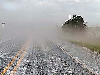
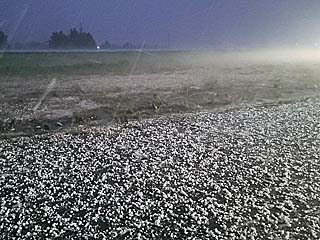
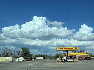
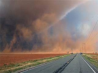
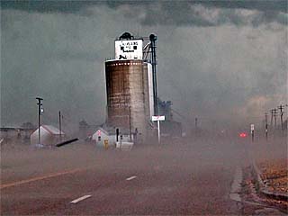
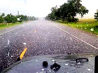
Hail fog and copious amounts of large hail cover the ground north of Guthrie, Texas. |
|
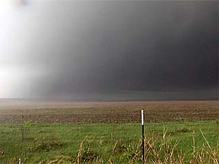
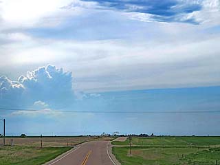
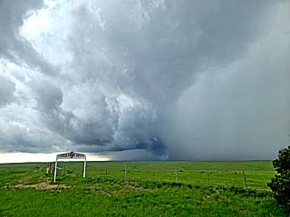
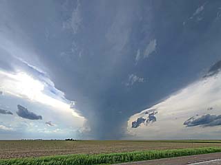
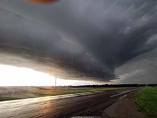
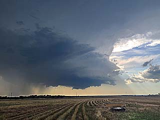
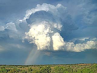
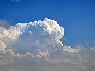
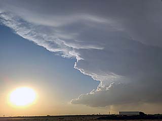
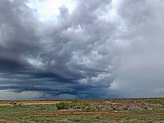
View of explosive updraft and supercell thunderstorm east and northeast of Guthrie, Texas. |
|
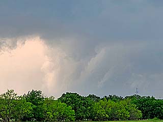
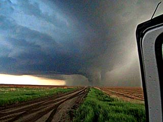
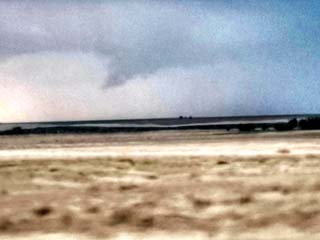
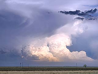
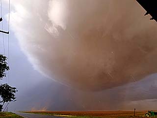
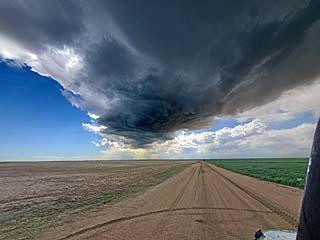
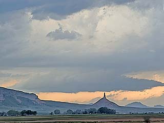
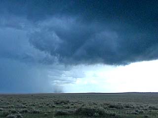
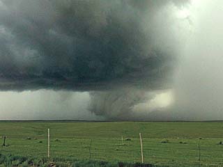
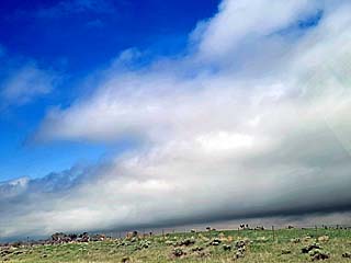
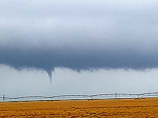
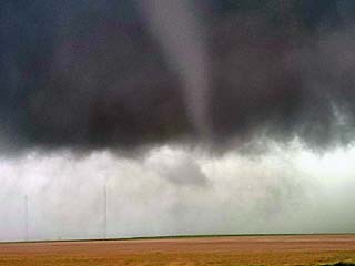
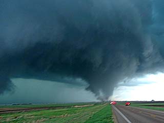
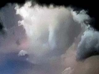
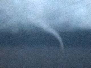
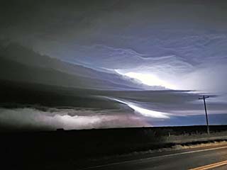
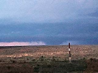
View of possible tornado from a distance looking north off Highway 82 east of Guthrie. The tornado is large, rain-wrapped / low contrast, and multi-vortex and under the "bowl shaped" lowering to the left side of the center of the picture. |
|
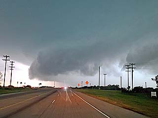
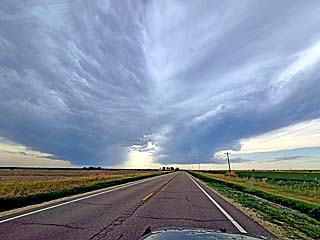
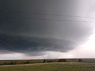
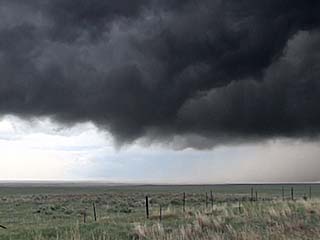
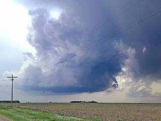
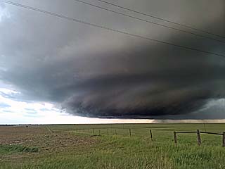
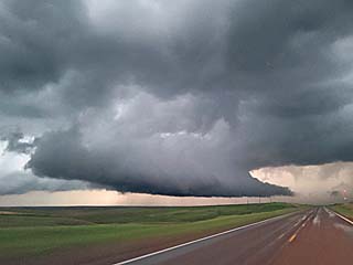
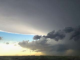
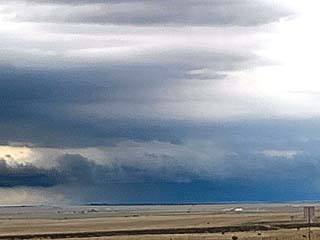
View of tornado-warned supercell storm north of Seymour, Texas. |
|
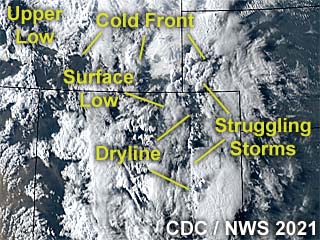
This is the annotated visible satellite at around 0z (late in the day on 4/28). Synoptic and convective features are noted, with two supercells (massive anvil blowoff) erupting over the north and south areas of central Texas. These are developing along a stalled frontal boundary (Pacific cold front and dryline), with upper level support for maintaining storms provided by an upper trough moving north of the area. |
|
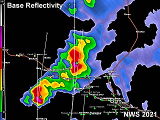
Base reflectivity radar image of a tornado-warned supercell storm over the northwest part of Fort Worth, Texas during the evening of April 28. This was part of a system of major hail storms that caused in excess of 3 billion dollars in damage. |
|
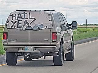
Obviosly another group of storm chasers (who lost their window on their chase vehicle) had a sense of humor while driving in Texas on April 28. |
|
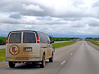
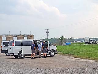
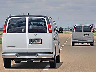
Heading south towards a severe storm / supercell nearing Goldsboro, Texas as a storm chasing tour group van also races south to catch it. |
|
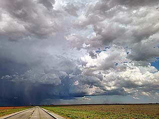
View of a developing supercell storm nearing Goldsboro, Texas as it is approached from the north. The view is to the south. |
|
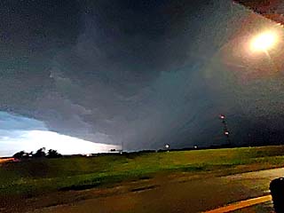
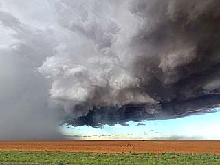
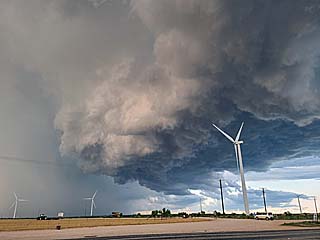
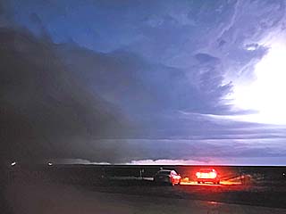
Powerful RFD winds in excess og 70 MPH, associated with an HP supercell and possible dust (weak spinup?) near Goldsboro, Texas. The view is NE. |
|
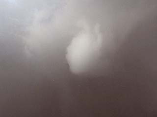
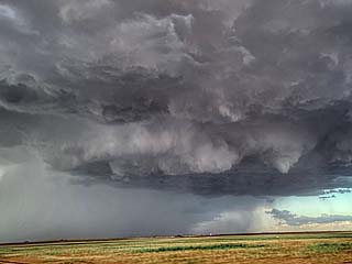
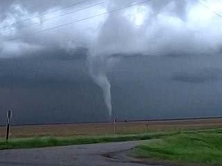
Possible funnel cloud near the wall cloud with a supercell storm near Cross Plains, Texas. The view is WSW. |
|
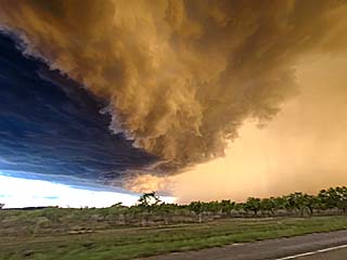
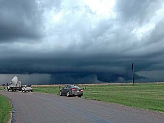
The same supercell storm later approaches the western areas of the Metroplex and passes near Weatherford, Texas late in the day. Here the wet RFD can be seen moving from right to left and its associated gust front. The view is looking south, directly under the low level mesocyclone in the "bear's cage". |
|
Large hail on the ground as the core of the supercell storm passes to the northwest side of Fort Worth, near I-820. This tornado-warned storm produced hail between 2.5 and 3 inches (baseball sized), and was a costly disaster that caused more than $3 billion in damages northwest of Fort Worth!. |
|
This is a visible image showing the synoptic environment around 0z, late on April 29. A large upper level low an be seen entered over Arkansas. To the east, a line of thunderstorms, supported by the exit region of the upper low / jet, is noted across Mississippi. One supercell in this line of storms produced a large tornado. |
|
This is a wide base-reflectivity image of severe storms over Mississippi and the central deep south at around noon on April 29. One cell in this line would eventually produce a tornado over south-central Mississippi. |
|
Time from April 29 to May 2 was off time and I was not chasing (some storms developed in the south / SE USA on May 2 but were too distant). In this picture, I am in Chinatown in Houston for dinner on April 30. |
|
This is an annotated satellite picture of the synoptic environment at around 0z during the late afternoon of May 3. Elevated / high-based storms can be seen over the western parts of Texas, with a complex of severe storms and supercells stretching from central Texas and northeastward into Oklahoma. |
|
This is a radar image (base reflectivity) from just before 6 PM CDT near Ardmore, Oklahoma, showing a supercell storm moving across the area. |
|
Awaiting convective initiation at a truck stop off I-35 and north of Ardmore, Oklahoma on May 3. |
|
View of a developing supercell to the west and northwest of Ardmore, Oklahoma. The view is to the northwest. |
|
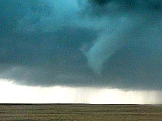
Brief funnel cloud off rotating wall cloud near Ardmore, Oklahoma. The view is to the west. |
|
View of rotating wall cloud northeast of Ardmore, Oklahoma. The view is to the northeast. |
|
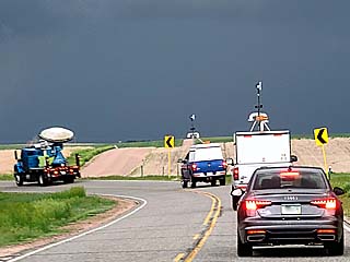
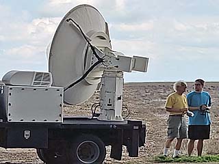
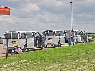
Chase tour group vans stopped along Highway 377 north of Tishomingo, Oklahoma. The smart DOW (Doppler on Wheels) radar truck can also be seen to the right. |
|
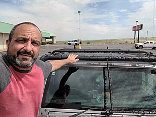
May 4-7 were off days and spent monstly in Wichita, Kansas. I was able to get some car maintenance finished and worked remotely those days at my IT job. In this picture, the Jeep is shown with the hail guards in place as curious people nearby look at it on May 6. |
|
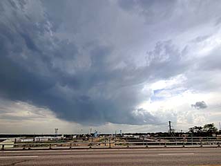
An elevated, non-severe storm appears west of Wichita during off time around May 6. |
|
Annotated visible satellite of the synoptic environment at about 0z during the afternoon of May 8. A warm front extends east across northern Kansas from a weak surface low in west-central Kansas. Some supercells are developing along the warm front and convergence area east of the surface low - Especially with the low-level jet increasing in the evening. The dryline / Pacific cold front to the southwest remained capped with little convection breaking out. |
|
This is a radar image of a severe storm / HP supercell near Salina, Kansas at around 8:45 PM CDT. The main image is the base reflectivity image, with the velocity image in the inset. The storm was evolving from an HP supercell to an MCS. |
|
Convective initiation west of Lacross, Kansas, during the afternoon of May 8 as upper level support for storms arrives with an upper trough axis. |
|
A view of two low precipitation supercells developing near and west of Lacross, Kansas. This is probably a storm split resulting in two separate LP supercells. |
|
View of high based LP storm becoming outflow dominant between La Crosse and Russell, Kansas. The view is to the west and northwest. |
|
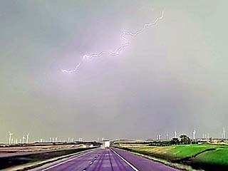
Lightning overhead on the backside of n HP supercell looking east over I-70 east of Russell, Kansas. |
|
A powerful HP supercell evolves to a line segment north of Salina, Kansas late in the day after sunset. |
|
Interesting laminar cloud formations, possibly associated with the low level jet intensifying at dusk. The view is to the south while headed south on I-35 north of Manhattan, Kansas. |
|
This is the annotated visible satellite image, during the afternoon of May 9 at around 23z. There is an area of severe storms / supercells developing along a pre-frontal convergence line to the south of a cold front across northeastern Texas. Ouflow from storms farther north kept storms at bay well northeast of my target area. |
|
Base reflectivity image of a small supercell storm southwest of Jacksonville, Texas at around 4 PM CDT. The inset shows the velocity associated with this storm. |
|
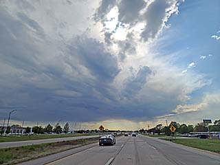
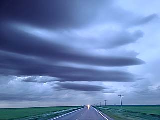
May 9 was a long chase with a long re-position south and ahead of a cold front. In this view, the line of towering cumulus can be seen looking south while near Dallas, Texas on I-35. |
|
Wall cloud on the southeastern side of a small supercell storm near Jacksonville, Texas during the afternoon. The view is to the northeast. |
|
Brief funnel (center of picture) as the supercell storm pushes to the southwest of Jacksonville, Texas. The view is to the southwest. |
|
Crepescular rays of sunlight peeking through clouds on the backside of a storm complex during the late afternoon near Mexia, Texas. |
|
The annotated visible satellite image here shows the synoptic environment around 0z for the afternoon of May 10. A surface based supercell is to the southwest near the stalled surface front, with elevated (post frontal) storms over central and northeastern Texas. |
|
This is the radar image for the storm approaching Leakey, Texas just after 4 PM CDT. The main image is the base reflectivity, showing the impressive presentation of the supercell storm. The inset is the velocity associated with the supercell. |
|
View of explosively developing supercell storm near Leakey, Texas on May 10 from near Sabinal. The view is to the northwest. |
|
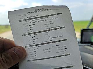
Always be super careful going through these small towns! I missed a school zone and was doing just 5 MPH over near Sabinal, Texas. Luckily I just got a written warning from a very friendly cop. |
|
View of base of the Leakey, Texas supercell storm and wall cloud from an elevated vantage point. The view s to the south and southwest in Real County. |
|
Rotating wall cloud on the southern side of a supercell storm over Real County, Texas, near Leakey during the afternoon. The view is to the north. |
|
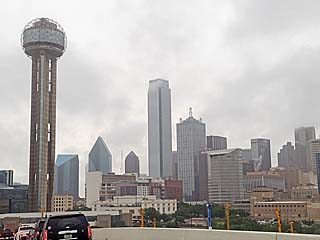
May 11 through 13 was down time, spent working at my regular IT job in Plano, Texas. Here I am headed through downtown Dallas on a dreary day. |
|
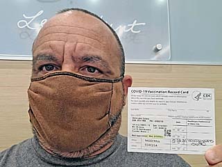
While on down-time I was also able to get my needed vaccination. Here I got my second Covid-19 vaccine on May 12. |

|
Myself working remotely for my regular IT job during any down time. |
|
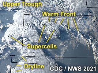
Annotated visible satellite image for the area at around 1z (evening of May 14). A warm front extends across northern and central Kansas, with a dryline farther west into SE Colorado. NW flow aloft is providing the upper level support for storms, as an upper trough glances the area to the north of a ridge. The supercells formed in two areas, my target area in Kansas, and another to the west in eastern Colorado. |
|
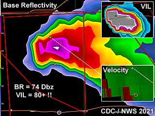
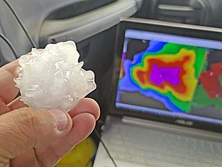
This is a radar composite of the supercell storm as it was near Hoxie, Kansas just before 8 PM CDT. The base reflectivity image shows an intense hail core, also denoted by the impressive VIL (vertically integrated liquid) in the upper-right inset. Velocity is shown in the lower right inset - Subtle but definitely showing a rotating storm. This storm produced hail approaching softball sized, and smaller pieces cracked the windshield on my chase vehicle. |
|
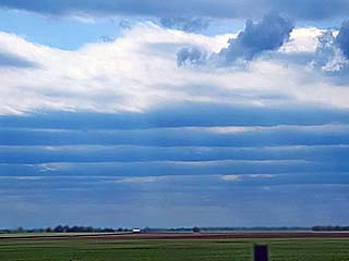
May 14 involved a long trip from northern Texas, through Oklahoma, and eventually into northwestern to north-central Kansas. While heading north on I-35, multiple HCRs (horizontal convective rolls) prevade the stable boundary layer looking west across central Kansas, indicative of strong wind shear. |
|
A supercell storm initiates near Hoxie, Kansas in a northwest flow environment. Note the wall cloud and impressive back-sheared anvil above it. The view is to the northeast. |
|
Same supercell evolving from classic to HP mode near Hoxie, Kansas, and turning right, eventually making its way to northwest of Wakeeney. This supercell eventually produced grapefruit sized hail. Here it is producing 2" hail (falling to the right). The view here is west and northwest. |
|
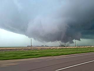
View into "notch" of HP supercell storm from Highway 281 north of Wakeeney, Kansas, late in the day. A funnel / possible weak tornado can be seen in the center of the picture. |
|
Copious amounts of hail, some pieces exceeding 2", covering the ground on the south side of Wakeeney, Kansas. |
|
This is an annotated visible satellite image for the afternoon of May 15, at around 0z. A small supercell storm had developed near Springfield, Colorado ahead of an MCS and in up-slope wind flow along the stalled frontal zone. |
|
This is a radar image of the small supercell storm east of Springfield, Colorado at around 6:30 MDT. The main image shows the base reflectivity, with subtle velocity in the inset. |
|
Developing towering cumulus as convective initiation takes place looking east out of Springfield, Colorado on May 15. |
|
Impressive hail core (whiter color is large hail shaft) associated with a developing supercell storm between Springfield and Campo, Colorado later after initiation. The view is to the south and southeast. |
|
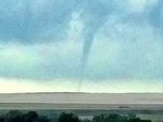
Brief funnel cloud observed from a distance looking west from north of Manter, Kansas late in the day as storms moved from SE Colorado int SW Kansas and weakened. |
|
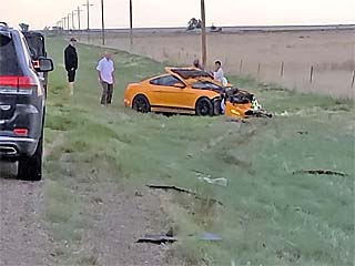
Stopping to assist a victim of a deer strike north of Manter, Kansas. The single occupant walked away without a scratch after striking a pregnant do (female deer) and careening out of control into the right ditch. The vehicle, a brand new Ford Mustang, as well as the deer, was totaled. |
|
View of de-coupling boundary layer (with associated laminar cloud formations) east of a developing MCS after dusk in SW Kansas. This is associated with a stable layer forming near the ground and intensifying low level jet just above the surface with isentropic lift above. |
|
This is an annotated visible satellite image of the synoptic environment during the late afternoon of May 16 at around 0z. A stationary frontal boundary stretches from east to west across the Texas Panhandle. Storms are firing along this boundary, with some supercells in the area where the boundary and dryline meet. The dryline extends south across west Texas, but convection along it is limited due to capping. Weaker up-slope storms area also ocurring in SE Colorado. |
|
This is a base reflectivity image of an LP to classic supercell storm southwest of Vega, Texas at around 6 PM CDT. The storm had rotation and a well-developed hail core at the time. |
|
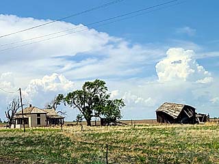
View of initial storms, stretching from the OK Panhandle and into NW Texas, with an abandoned farmstead in the foreground, while passing by Guymon, Oklahoma on May 16. |
|
One of a few LP supercell storms, develping near Amarillo, Texas along a sharpening dryline. The view is to the east and northeast. |
|
An LP supercell develops in the late afternoon southwest of Vega, Texas. |
|
Hard rotation on an LP to classic supercell storm to the southwest of Vega, Texas. |
|
View looking straight up of falling large hail with the Vega, Texas LP supercell! |
|
Another LP to classic supercell (note the split taking place) near Earth / Sedan looking southeast from near Vega, Texas. This distant storm produced a small tornado at the time. |
|
The annotated satellite image for roughly 0z (afternoon of May 17), showing important features of the late day. A group of supercells, some tornadic, is developing near the intersection of a sharp dryline and stationary frontal boundary, as well as slightly southeast of there in the free warm sector. |
|
This a radar image of a tornado producing supercell southwest of Snyder, Texas at around 7:30 PM CDT. The main image shows the intense base reflectivity, and velocity in the inset to the upper-right. |
|
Convective initiation over west-central texas during the afternoon of May 17, as a dryline sharpens west of the area. |
|
A tornadic supercell forms to the southeast in a separate target area east of Midland, Texas. This storm produced a large (wedge) tornado, but was mostly HP in nature. |
|
An LP supercell initiates near La Mesa, Texas and quickly moves northward. |
|
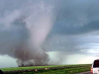
The LP supercell rapidly stengthens near Sundowd, Texas and aquires a beautiful structure as it evolves to classic mode. |
|
Close range view of a weak tornado developing with an LP / classic supercell to the north of FM 1585 to the southeast of Levelland, Texas late in the day. |
|
Ground circulation of the tornado southeast of Levelland, Texas. |
|
Looking straight-up overhead at the funnel of the tornado southeast of Levelland, Texas! |
|
Absolutely incredible colors with the powerful RFD kiking up dust in the low sun angle late in the day southeast of Levelland, Texas. One storm chaser (Hank S, aka "Pecos Hank") compared his view of this scene to the "atmosphere on Jupiter". |
|
Supercell weakens and undergoes a split between Levelland and Wolforth, Texas. A developing final weak tornado is developing from the left split on the left side of this picture. The view is to the east and northeast. |
|
Another brief tornado develops between Levelland and Wolforth, Texas ... Note the contact "swirl" to the far lower left in the picture (confirming ground contact). |
|
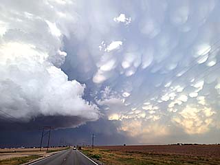
View looking east of the supercell right split (left side of this picure) as it was west of Lubbock, Texas, with incredible mammatus overhead. |
|
Supercell weakens and undergoes down-scaling in a highly sheared environment at dust just east of Lubbock, Texas. Basically the formerly violent storm "shrivels" and evaporates into nothing! |
|
This is a visible satellite image for around 0z during the afternoon of May 18. The area of importance (target area) is near the intersection of a dryline and weak frontal / outflow boundary. The MCS in southeastern Texas is of no interest in today chase prospects. A powerful supercell has also developed in my target area, near La Mesa south of Lubbock. Some brief tornadoes ocurred with this storm. |
|
This is a radar image of a supercell storm near La Mesa, Texas at around 7:30 PM CDT. The main image is the base reflectivity, and velocity is in the inset to the upper-left. |
|
Blasting east to a supercell storm that has rapidly formed near La Mesa, Texas after abandoning an original target south of Clovis, New Mexico. The storm of interest is in the distance, to the right of the center of this picture. The view is to the southeast on May 18. |
|
Storm chasing tour vans also racing east to catch the developing supercell storm northwest of La Mesa, Texas during the afternoon. |
|
View of supercell storm and updraft base north of La Mesa, Texas. The view is to the east. |
|
Rotating updraft of the now classic supercell north of of La Mesa, Texas. The view is to the east and northeast. |
|
View of weak tornado to the northwest of LaMesa, Texas during the afternoon. A brief ground circulation was visible under the funnel to the right side of the updraft base. The view is to the northeast. |
|
View of weak tornado ground circulaton from the La Mesa storm. The view is to the west and northwest. |
|
View of the La Mesa supercell moving east and evolving to HP mode over a wind turbine farm. The view is to the northeast. |
|
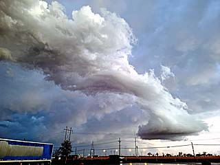
Incredible colors near sunset as the HP supercell evolves to a line segment and becomes outflow dominant with near perfect lighting of the "whales mouth" from the setting sun. The view is to the south. |
|
View looking east at the intensifying MCS with hail covering the roadway in the foreground, and wrapping up another great chase day. |
|
May 19 was an off / travel day heading from Lubbock, Texas to the Denver, Colorado area. In this picture we see a view of the Twin Buttes with a non-severe storm in the background north of Springfield, Colorado looking east from Highway 385. |
|
This is an annotated visible satellite image for the synoptic environment over Colorado as of 22z on May 20. Some small supercells are developing in up-slope wind flow north of the Palmer Divide and into SE Wyoming, with an inactive dryline extending into southeastern Colorado. An MCS also has formed in eastern and northeastern Wyoming. |
|
This is a radar (base reflectivity) image of an LP supercell storm north of Last Chance, Colorado at about 3:30 PM MDT. The storm had a pretty decent organization on the base reflectivity image, before moving north and weakening near Brush, Colorado. |
|
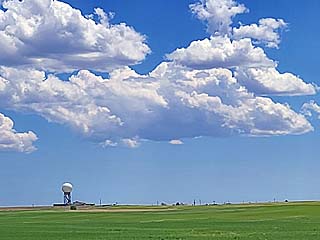
Convective initiation began along and to the northeast of the Palmer Divide on May 20. In this view, towering cumulus is developing in up-slope wind flow. The radar (radome) in the foreground is for the terminal Doppler WSR-95D radar used by Denver International Airport. The view is to the southeast. |
|
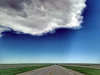
Interesting shadow of a developing supercell's anvil casted eastward while driving east on Highway 36 west of Last Chance, Colorado. |
|
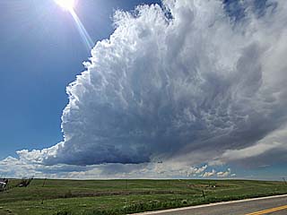
A small LP (low-precipitation) supercell develops northeast of the Palmer Divide between Last Chance, Colorado and Brush. The view is to the west from SR 71. |
|
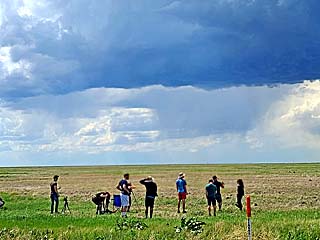
A group of storm chasers enjoys the view of the LP supercll west of SR 71. |
|
View of LP supercell moving north from west of Last Chance, Colorado and eventually weakening southwest of Brush. The view is to the west, basically in the middle of no where (Weld County). |
|
This is an annotated visible satellite image of the area of interest, at roughly 0z during the afternoon of May 21. A rather "messy" convective evolution is taking place, with a cold front pushing southward through SW Nebraska, and a weak surface low over NE Colorado with a diffuse dryline extending southward out of there. Lack of robust upper level support precluded a more intense convective event. |
|
This is a base reflectivity radar image of some storms over SW Nebraska at about 6 PM MDT. There are two supercell storms in this storm complex, but quickly became undercut by the cold front and weakened. |
|
My chase vehicle getting ready to chase another day in northeastern Colorado on May 21. |
|
Myself in Sterling, Colorado waiting for the capping inversion to erode and storms to fire, while in winds gusting out of the south in excess of 45 MPH. |
|
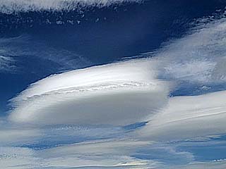
Interesting lenticular clouds as the capping inversion gets eroded near Sterling, Colorado. |
|
Intensifying supercell storm moving from west of Sterling, Colorado and northward into Wyoming. The view is to the southwest. |
|
A weakening severe storm with a wall cloud (getting undercut by a sharp cold front) looms behind Castle Rock looking towards the west in Scottsbluff County, Nebraska late in the day. |
|
This is an annotated visible satellite image of the synoptic environment over Colorado at roughly 20z in the early afternoon of May 22. Storms have developed over NE Colorado, with tornadoes reported. This was ahead of a lee cyclone / surface low departing eastward, and south of a stalled cold front to the north. |
|
This a base reflectivity image of a tornado-producing supercell west of Akron, Colorado at about 1:30 PM MDT. The velocity of the storm is shown in the upper-right inset. |
|
Convective initiation on May 22 to the southwest of Akron, Colorado during the early afternoon. |
|
One of the supercells to the northwest of a cluster of supercells, removed from the more-favored southern most storms (southwest of Akron, Colorado), acquires hard rotation and a prominent funnel forms. The view is to the west and southwest. |
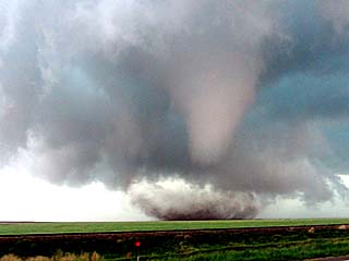
|
Finally, and quite rapidly, a beautiful elephant trunk tornado looms to the southwest of Akron, Colorado during the early afternoon. The view is to the southwest. |
|
This is a close up of the tornado southwest of Akron, Colorado just before rope-out. |
|
Another tornado, albeit not fully condensed, develops to the southeast of Brush, Colorado. The view is to the southeast. |
|
A final third tornado, also weak and not condensed, develops near Brush, Colorado as the parent storm weakens and moves into a cooler air mass to the north. The view here is to the west. |
|
This is an annotated visible satellite image of the synoptic environment for the day, during the afternoon of May 23 around 20z. A powerful supercell can be seen lumbering across northeastern Colorado, ahead of a departing surface low, dryline, and within up-slope wind flow. |
|
This is a radar image (base reflectivity) of a powerful tornadic supercell between Anton and Akron, Colorado just after 3 PM MDT. The velocity image is in the upper-right inset. |
|
Heading south into east-central Colorado near Anton on May 23. The ominous view of anvil blowoff streams overhead from a developing storm east of the Palmer Divide and moving northeastward towards me. The view is to the south. |
|
We are all following the same thing: Storms! Here a small caravan of researchers is heading towards the developing storm in east-central Colorado near Anton. |
|
Reaching the supercell storm near Anton, Colorado, it clearly has an HP structure. The view is to the southwest. |
|
Closer view looking southwestwards and straight into the HP supercell "notch". Not sure if there is a weak tornado under this rapidly rotating wall cloud. |
|
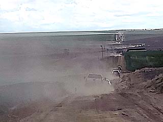
One of many dirt roads north of Anton, Colorado with a caravan of chasers heading east, kicking up dust, to get a view of a tornado warned storm to the northwest. |
|
Wide view of the same supercell, passing north of Anton, and south of Akron, with intersecting boundaries and a cone tornado forming! The view is to the north and northwest. |
|
Closer view of the cone tornado that appeared with this supercell over the Colorado prarie between Anton and Akron, Colorado during the early afternoon, as many chasers caravanned east on a dusty dirt road. The view is to the north and northwest. |
|
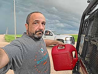
Myself filling up (I always carry spare fuel) on a remote road southeast of Sterling, Colorado as some local farming residents stop and ask if I need assistance. People out here are the nicest and most honest people I ever came across. |
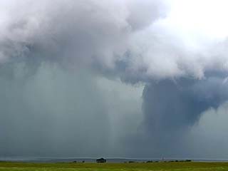
|
Another possible tornado, shrouded in a pall of rain and hail, appears in an HP supercell storm southeast of Sterling, Colorado. The view is to the northwest. |
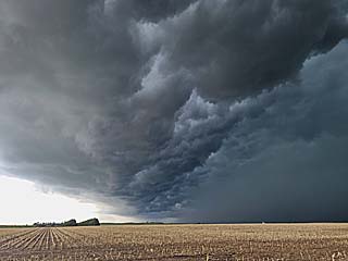
|
The storm becomes outflow dominant and produces a powerful gust front to the east of Sterling, Colorado. This is the "whales mouth", an intriguing cloud formation on the backside of the shelf cloud. The view is to the south. |
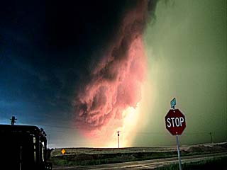
|
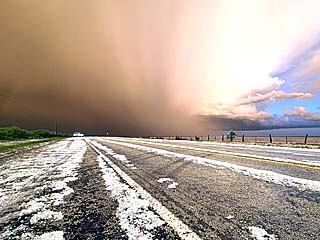
Absolutely incredible colors at dusk as a severe MCS pushes its way east out of eastern Colorado and into southwestern Nebraska. The blue is the clear sky to the east (left), red the setting yellow sunlight reflecting on the "whales mouth" of the gust front, and green (right) caused by light scattering through large hail. The view is to the south and southwest. |
|
This is the annotated visible satellite image between 23z and 0z (late afternoon of May 24). The tornado-producing storms are ahead of a low pressure area / Pacific cold front near western Kansas, and along the outflow boundary stalled across NW Kansas. |
|
This is a base reflectivity radar image of the tornadic supercell that developed near Selden, Kansas at around 6 PM CDT. The velocity image for this supercell is in the upper-right inset. Note the "debris ball" to the lower left in the image! |
|
A sign of things to come. A stationary frontal boundary stretches from the east-northeast to west along north-central to northwestern Kansas suring the morning of May 24. This is near Sharon Springs, looking northwest. The distinct line of the surface boundary can be seen, with fog and stratus to the north, and warm, clearer skies to its south. |
|
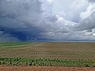
A classic supercell storm fires up northwest of Leoti, Kansas as the dryline pushes eastward into the area during the early afternoon. |
|
The Doppler On Wheels (DOW) research truck scanning the Leoti, Kansas supercell as Howard Bluestein watches to the right with his colleague. It became clear that the Leoti storm was not going to be a prolific tornado producer, so many chasers headed north. |
|
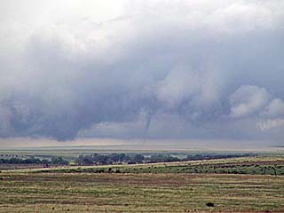
While headed north (and back) towards Sharon Springs, Kansas, it became clear where the low level shear was the best, with multiple small tornadoes visible along a cluster of supercells. A tornado looms over the distant horizon looking west towards one of these small supercell storms. |
|
Closer view of an on-going tornado, looming over the distant horizon, looking west from near Sharon Springs, Kansas during the afternoon. The view is to the west. |
|
As the storms moved north and northeast, they interacted with the stalled boundary draped across the area. Persistant and multiple small funnels like this were observed as one powerful supercell storm "rode the boundary" and passed near Colby, Kansas. |
|
View of supercell storm northeast of Colby, Kansas, and evolving to HP mode, with storm chasers and the DOW truck in the foreground. |
|
The supercell storm evolved to HP, became outflow dominant, and back to classic mode with this funnal / tornado as it passed near Rexford, Kansas. The intensifying low level jet allowed the storm to wrap back up again by late afternoon / evening. |
|
Classic supercell moves east of Rexford and approaches Selden, Kansas, and rapid tornado-genesis ensues. The view is to the northeast. |
|
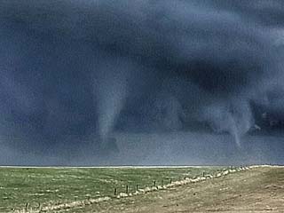
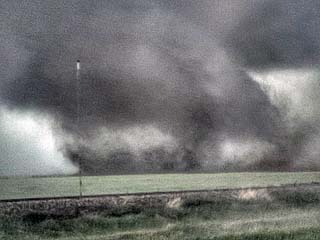
Close up of developing, and rapidly intensifying, tornado west of Selden, Kansas. The view is to the northeast. |
|
A significant tornado matures to the west of Selden, Kansas. The view is to the northeast. |
|
Close-up of debris cloud / contact "swirl" of the tornado west of Selden, Kansas. This was the most intense phase of this tornado, which weakened considerably before reaching Selden, fortunately. |
|
Another view of the Seldon, Kansas tornado, amidst storm chaser traffic, before the tornado hit the town. |
|
Multi-vortex and rapid motion just west of Selden, Kansas. The view is to the east. |
|
The tornado hits Selden, Kansas directly, fortunately at high-end EF-1 intensity. In this picture, looking east, dust and debris can be seen airborne over the town. |
|
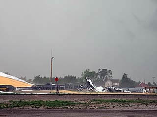
Damaged farm supply complex in Seldon, Kansas after the tornado passed through the town. |
|
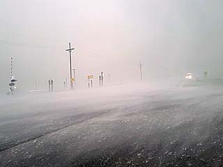
Powerful RFD (rear flank downdraft) winds and rain "hook" slamming by eastern Selden with winds near 100 MPH. This felt like being in a hurricane, with whipping winds and rain, but with large hail. |
|
Overturned semi-trucks east of Selden, Kansas. These two folks actually passed us and drove INTO the tornado earlier, despite myself and other chasers screaming at them not to do so. |
|
Tornado pushes well east of Selden, and back over open country, weakens to a large funnel cloud, then rotating wall cloud. The view is to the northeast. |
|
The once violent Selden supercell undergoes down-scaling and shrivels up into nothing. In this picture, the storm is merely a rotating (and highly tilted / sheared) towering cumulus, and has a final small funnel at its base by dusk. |
|
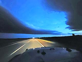
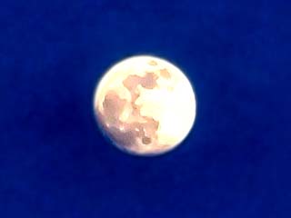
Beautiful moon peeking through the post storm environment after clouds cleared out during the late evening. What a day! |
|
This is an annotated visible satellite image of the synoptic and convective environment as of 1z (during the evening of May 26) over the Texas and Oklahoma Panhandles. Two areas of supercells have fired, one over the SE Texas Pannhandle, and another from near Amarillo northward to the TX / OK border. These storms produced very large hail and were in an area of cap erosion ahead of the northern portion of a dryline segment near a weak surface low |
|
This a base reflectivity radar image of one of the intense supercell storms over the Texas Panhandle near Perryton, Texas after 9 PM CDT. Subtle velocity is also shown in the upper-right inset. |
|
Heading southward from SW Kansas, through the OK Panhandle, and into the extreme northern Texas panahandle on May 25. The atmosphere remained "capped" to the north, with a window of convective opportunities over the TX / Oklahoma panhandle border. Here some cumulus can be seen developing along a stationary boundary looking south. |
|
Storms finally firing and breaking the strong cap just south of the OK / TX border in the northern Texas panhandle. |
|
A small supercell storm, with a prominent hail shaft, appears near Perryton, Texas near dusk from the previous convection breaking the cap. The view is to the south. |
|
Marble sized hail splashing in the road near Perryton, Texas. |
|
Closer view of the hail core, with hail shaft illuminated by the setting sun, near Perryton, Texas. The view is to the east. |

|
Lightning illuminates the supercell storm after dark near near Perryton, Texas. Note the weak funnel in the RFD clear clot (center of piture). The view is to the northeast. |
|
Closer view of weak funnel with a supercell storm after dark near near Perryton, Texas. |
|
This is an annotated satellite image showing the convective and synoptic environment during the afternoon of May 26 at around 0z. Tornadic supercells are on-going in north-central Kansas and into SW Nebraska. Note my initial target area, and southward across western Kansas (along with many other storm chasers), is remaining capped. |
|
This is a base reflectivity radar image of a tornadi supercell storm south of Hill City, Kansas at roughly 9 PM CDT. The velocity of the storm is in the upper-right inset. |
|
Ready for the day ... Three storm chase tour vans wait at a truck stop near Scott City, Kansas during the afternoon of May 26. |
|
Storms begin firing along the western Kansas dryline. Here an LP supercell is rapidly forming to the west and northwest of Scott City, Kansas. Strong difluence aloft causes the anvil to appear that way, fanning out above us. The view is to the west. |
|
Closeup of one of the LP supercell storms developing northwest of Scott City, Kansas. Note the mid-level funnel just right of the center of the picture. The view is to the northwest. |
|
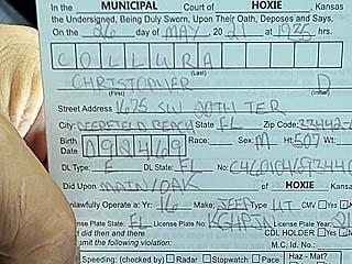
Luck turns sour as the LP storms fell apart in the main target area, forcing many chasers to race towards other targets. Passing through Hoxie, Kansas, I get a ticket for slowly rolling through a stop sign. Not so lucky this go-around. |
|
A complex of storms forms to the east of Hoxie and west of Hill City, Kansas by late afternoon / early evening. I am headed south of this storm complex to the "tail end" supercell. The view here is to the northwest. |
|
Tail-end supercell on the southern end of the storm complex near Hill City, Kansas. Rapid motion was noted with this storm. The view here is to the west and southwest. |
|
A tornado quickly develops and touches down in an open field south of Hill City, Kansas near dusk off the tail end storm of a complex of severe storms. The view is to the northeast. |
|
Close up of ground circulation associated with the brief tornado pictured above in an open field south of Hill City, Kansas. |
|
View looking up at the parent funnel with the brief tornado south of Hill City, Kansas. |
|
Impressive wall cloud with the same Hill City supercell as it moves off to the northeast. The view is to the north. |
|
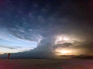
Incredible lightning looking north at the supercell storms after dusk in the twilight just north of I-70 in north-central Kansas. |
|
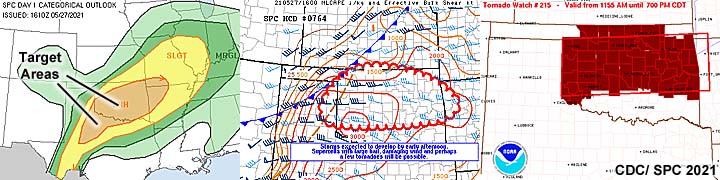
In this annotated visible satellite image, storms are developing near surface features. One cluster ahead of a cold front in Oklahoma evolving to an MCS, and LP (low precipitation) storms ahead of the dryline in the SE Texas panhandle. This image was from about 23z, during the afternoon of May 27. |
|
This is a base reflectivity radar image of an LP supercell storm near Turkey, Texas in Hall County just before 7 PM CDT. |
|
Rotating wall cloud west of I-35 and north of Mulhall, Oklahoma, during the early afternoon of May 27. The view is to the southwest. |
|
Low precipitation supercell left split over Hall County, Texas late in the day. The view is northwest. |
|
Large hail falling from the LP supercell in Hall County, Texas. |
|
Low precipitation supercell right split with updraft, RFD, and hail shaft moving east over Hall County, Texas. The view is to the east. |
|
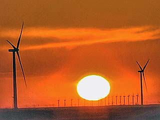
Beautiful sunset amidst wind turbines wraps up the day to the northeast of Lubbock, Texas. |
|
This is an annotated visible satellite image of the convective environment across western Texas and New Mexico during the afternoon of May 28, at around 23z. Two powerful supercells are lumbering across the target area in SW Texas, with an MCS in south-central Texas. Another supercell complex is in eastern New Mexico, evolving to a forward-propagating MCS. A dryline and stalled frontal boundary are providing a focus for the strongest storms. |
|
This is a base reflectivity radar image of a powerful supercell storm northwest of Pyote, Texas at around 7:30 PM CDT. The velocity of this storm is also shown in the inset to the upper-right. |
|
Convective initiation looking southward over south-central to southwestern Texas late in the afternoon of May 28. |

|
Intersecting outflow boundaries east of Ward County, Texas with an outflow dominant supercell to the east. The view is to the southeast. |
|
View looking northwest towards Ward County and a developing supercell storm. Note the impressive anvil blowoff streaming overhead. The view is to the west and northwest. |
|
Low precipitation to classic supercell north of Pecos, Texas in Ward County late in the day. The view is to the west. |
|
One of the smaller pieces of hail picked off the ground (about 2" and melting) near Pyote, Texas on I-20. |
|
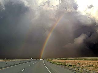
View of hail core and rainbow over I-20. The view is to the northeast and east. |
|
Looking west at a high based LP supercell west of Pyote, Texas and I-20. |
|
Lightning illuminated picture of the leading edge of a powerful MCS / bow segment west of Andrews, Texas after dark. Note the "haboob" (dust kicked up) under the gust front! The view is to the northwest. |

|
This is an annotated visible satellite image of the synoptic / convective environment at around 0z during the early evening of May 29. A surface low (lee cyclogenesis) has developed over SE Colorado and is slowly departing eastward. A cyclic tornadic supercell is also shown in the SE corner of Colorado and about to move SE into the western Oklahoma panhandle near Black Mesa country. |
|
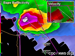
This is a base reflectivity radar image of a tornadic supercell moving southeastward over the extreme NW corner of the Oklahoma panhandle at around 8:30 PM. Note the intense hail core, at least 74 dBz (white on base reflectivity). The intense velocity is also shown in the upper-right inset. |
|
Convective initiation west of Springfield, Colorado near Baca County during the afternoon of May 29. The view is to the west. |

|
It is not a good idea to follow a storm chaser. This humerous message saying not to do so it written in the dust on the back of this storm chaser's vehicle. |
|
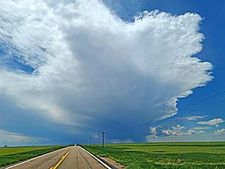
Intesifying storm going from multicell to supercell evolution (still with a high base) near Baca County, Colorado by mid to late afternoon. The view is west and northwest. |
|
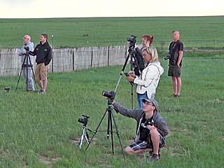
Storms chasers with camera gear in a field near Baca County, Colorado filming lightning and storm structure. |
|
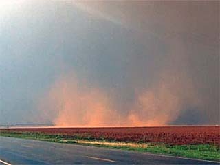
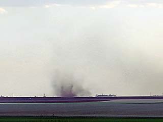
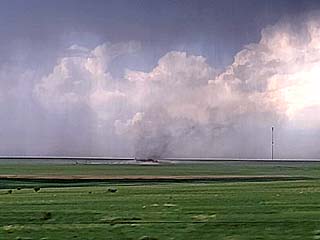
A small landspout tornado picks up dust in a field beneath the RFD region as the Baca County storm begins moving southeastwards. |
|
The Baca County storm continues moving southeast and right of the mean vector, rapidly intensifying, as it draws upslope air along the moisture axis by late afternoon. The view is to the southwest. |
|
View of a large cone tornado (just left of center of picture) becoming rain-wrapped to the west of Campo / SW of Pritchett, Colorado late in the day. The view is to the west. |
|
Large caravan of storm chasers, including tour group vans, headed south to stay ahead of the Baca county supercell and nearing the Black Canyon country. |
|
View of large tornado looking west as precipitation temporarily clears out with incredible supercell structure, as the storm moves from Baca County, Colorado into the Black Canyon country in extreme NW Oklahoma. |
|
Tornadic storm re-emerges from the rugged terrain and into the Black Canyon by evening in the extreme NW Oklahoma panhandle. The view here is to the north, with a possible tornado on-going (just below center of picture). |
|
Incredible storm-relative inflow as the low level jet intensifies in the evening. Note the inflow bands extending from the tornadic supercell to the far left and to the right. The view here is to the northeast. |
|
Supercell storm continues southeastwards and into the night over the western OK panhandle. Large tornado is on-going under the storm in the lower right side of the photo. This wide-angle view is to the north. |
|
View of intense (now cyclic) supercell storm, with tornado (just below center of the picture and possibly splitting into two tornadoes) on-going under it, as an intense bolt of lightning strikes to the far right. The view is to the north and northwest. |
|
Closer view of the SW side of the powerful cyclic supercell to the northwest of Boise City, Oklahoma, with two tornadoes on the ground simultaneously (probably a satellite tornado rotating about a developing wedge tornado). The view is to the north, illuminated by lightning. |
|
Large wedge tornado to the northwest of Boise City, Oklahoma The view is to the northwest, illuminated by lightning. |
|
Last (wide-angle) view of the large, on-going wedge tornado, fortunately weakeing and evolving to multi-vortex while remaining safely away from Boise City, Oklahoma. The storm weakened thereafter during the night, before it could hit any towns. |
|
This is an annotated visible satellite image for around 0z during the late afternoon of May 30. The outflow / frontal boundary across the Oklahoma panhandle is providing a focus for tornadic supercells. Another supercell in up-slope wind flow is farther southwest in New Mexico as well. |
|
This is a base reflectivity radar image of a tornadic supercell near Felt, Oklahoma (between Clayton, New Mexico and Boise City, Oklahoma) at around 5:30 PM CDT (4:30 MDT). The velocity is in the upper-right inset. |
|
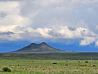
View of the Capulin volcano near Clayton, New Mexico while headed south and southwest on May 30, targeting east-central New Mexico (a mistake). |
|
Realizing storms in east-central New Mexico were not very organized, I turn back north towards Clayton and target storms moving into Oklahoma. In this picture, a messy and outflow-dominated storm looms north of Nara Visa looking westward. |
|
While re-positioning north and northeast past Clayton and looking towards Felt, Oklahoma, a tornadic supercell looms over the horizon. From distant range, a possible tornado is barely visible under the storm below and just left of the center of the picture. The view is to the northeast. |
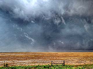
|
Closer in to the storm, this is an enhanced low-contrast view of a large tornado (center and left side of picture) near Felt, Oklahoma during the afternoon. The view is to the northeast. |
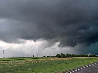
|
Strong RFD region with the storm as it moves past Felt, Oklahoma and to the southwest of Boise City. The feature handing down in the foreground in the center of the picture is a "scud bomb" and not the tornado. The tornado, if it's still there, would be behind the bright area (RFD slot) between the left-center and lower-left part of the picture. The view is to the northeast. |
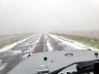
|
Hail covers the ground and roadway to the southwest of Boise City, Oklahoma as the hail core of a tornadic supercell passes nearby town of Felt. |
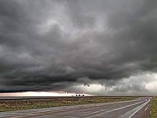
|
Weakening of the supercell storm and evolution to a cluster of severe storms to the south of Boise City, Oklahoma by the late afternoon. The remnants of the storm mesocyclone can be seen in the center of the picture. The view is to the northwest. |
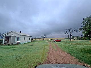
|
Wrapping up the May 30 chase, passing through the desolate town of Two Buttes, Colorado. This is the real "Little House Of The Prarie"! |
|
May 31 onward was down time, mainly spent working at my regular IT job in Chicago, Illinois until June 16. In this picture is the state Capitol building in Des Moines, Iowa. Storm activity ramped down substantially in early June of 2021. |
|
World's largest truck stop off I-80 in eastern Iowa, between Davenport and Iowa City. |
|
Crossing back over the "mighty" Mississippi River - Looking north here, Iowa is to the left, and Illinois is to the right. |
|
Passing off time (while not chasing) in the Chicago suburbs, including skydiving at CSC (Chicago Skydiving Center) near Rochelle, Illinois. |
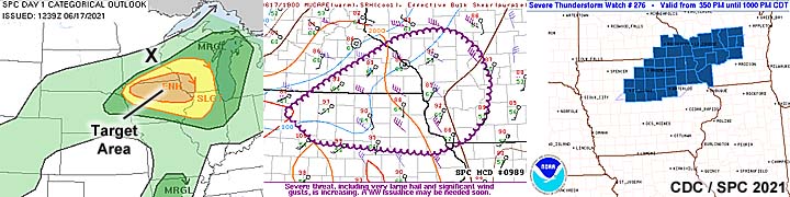
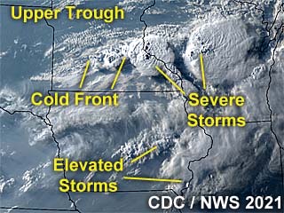
|
This is an annotated visible satellite image for after 1z during the evening of June 17. Severe storms can be seen erupting over SE Minnesota and neaded into western Wisconsin near dark, thanks to a cold front pushing across the area. |
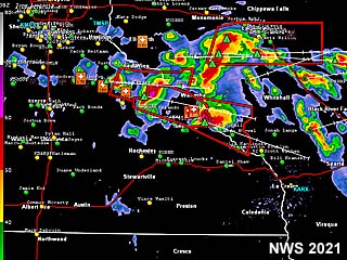
|
This is a base reflectivity radar image of the convective evolution after 8:30 PM CDT. Most of the severe storms are developing way north of the MN / IA border and heading across the Mississippi river and into western Wisconsin. |
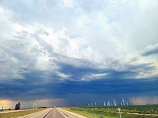
|
This is a picture of some elevated storms developing in a highly capped environment near Floyd in northern Iowa during the afternoon of June 17. |
|
Iowa has a large community of Amish people. Here a horse-drawn wagon can be seen along the side of the highway in northern Iowa. |
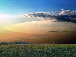
|
Distant view of anvil from severe storms and superells over southeastern Minnesota (80 miles away) over the horizon. The view is to the north. These storms developed well north of the target area(s) due to capping to the south. |
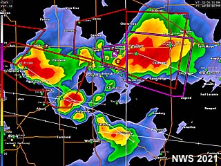
|
June 18 and 19 were off days spent in the Chicago area. This is a base reflectivity radar image on June 18 around 3:30 PM CDT of tornado producing supercells in east-central Indiana, and crossing into western Ohio. No chasing was done this day on June 18 as the good storms were distant and too far to chase. |
|
Barge lumbering down the upper Mississippi River heading east on I-80 between Iowa and Illinois. |

|
Here an ominous PSA ad reminds eveyone disaster is always possible, and foreshadows what will happen before midnight on June 20 in the Chicago suburbs with a damaging tornado happening there. |
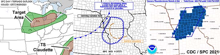
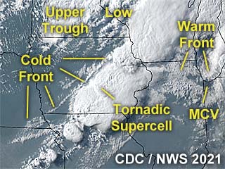
|
This is an annotated visible satellite image for around 0z during the evening of June 20. Severe storms can be seen stretching from southern Wisconsin and southwestward into northern Missouri. A powerful supercell that produced tornadoes near Pella, Iowa can be seen in central to eastern Iowa. This activity is ahead of a cold front. A damaging rain-wrapped tornado also affected the Chicago suburbs before midnight from the resultant squall line later as it pushed east towards the Great Lakes. |
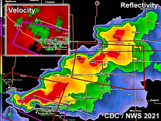
|
This is a base reflectivity radar image of a powerful "tail-end" supercell on the SW side of a cluster of severe thunderstorms near and east of Pella, Iowa at roughly 6:30 PM CDT. This was a tornado-producing storm. The velocity of the supercell is shown in the inset to the upper-left. |
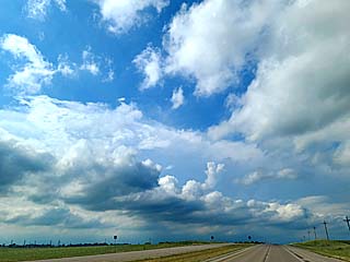
|
Approaching a developing cluster of strong and severe storms over Bremer County, Iowa during the afternoon of June 20. |
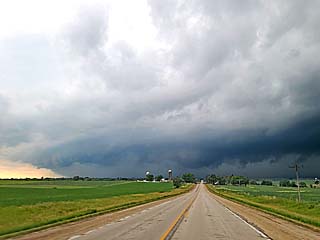
|
The storms near Bremer County, Iowa become severe, with a brief supercell on the southern end of the storm complex, before becoming outflow dominant due to a surging front to the north of the primary target area. |
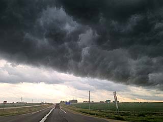
|
Impressive "whales" mouth on the backside of the outlow-dominant storm near Plainfield, Iowa during the afternoon. The view is to the south. I am abandoning this complex of storms and favoring a storm complex developing farther south and southwest in an environment much more favorable for tornadoes. |
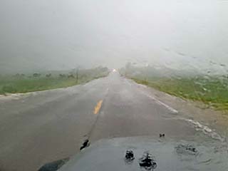
|
Racing south towards a supercell storm near Pella, Iowa (after a long re-position south along Highway 63) late in the day. A tornado was reported at this time, and I am punching through the precipitation core of the storm from the north. |
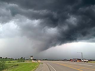
|
A weakening tornado lifts to the east of Pella, Iowa. The view is to the north along Highway 63. |
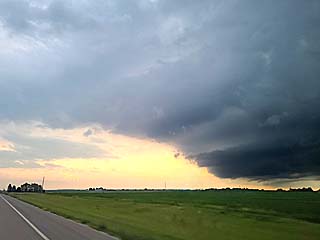
|
The former Pella storm weakens and re-intensifies southwest of Keota, Iowa before dusk. The view os to the southwest and south, with the intensifying storm to the far right. |
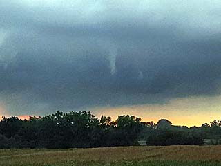
|
A funnel forms on the updraft base of the supercell storm SW of Keota, Iowa as it re-intensifies. |
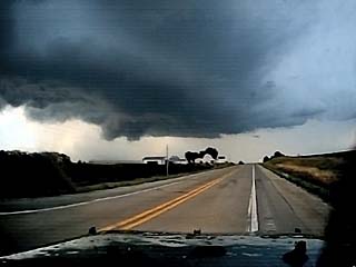
|
Ominous view of updraft base, storm structure, and RFD region (left) near Keota, Iowa. Note the rotating wall cloud as well, just left of the center of the picture. This storm, formerly the one that produced the Pella tornado, has been re-issued a tornado warning. The view is to the north. |
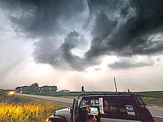
|
Ominous swirl of fast moving clouds looms over the chase vehicle near Keota, Iowa along SR 92. The view is looking to the NW as this tornado-warned supercell storm pushes ESE over the area. |
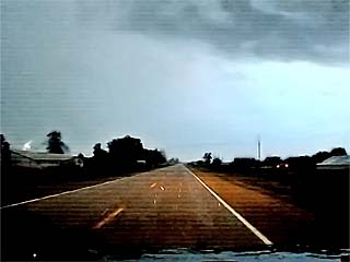
|
Hail up to 2" in diameter falls on the northeast side of the tornado-warned supercell storm between Keota and Washington, Iowa while heading eastward along SR 92. |
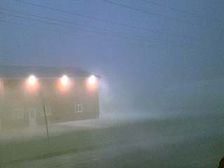
|
Powerful RFD and outflow winds in excess of 70 MPH pummel the southwest side of Washington, Iowa after dusk as the supercell storm finally "gusts out" and becomes outflow dominant. |
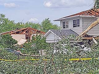
|
A powerful tornado affected the Chicago suburbs from Naperville to Woodridge, Illinois, just before midnight on June 20. I did not chase this setup (I was farther west in Iowa due to visibility and not willing to chase storms after dark in populated areas). Here we see downed trees and major roof damage to residences in Woodridge on June 21. |
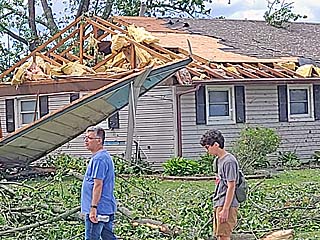
|
Locals wandering in the street and roof damage to a home in Woodridge, Illinois. |
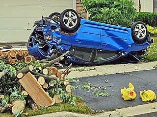
|
Overturned and totaled car in Naperville, Illinois. |
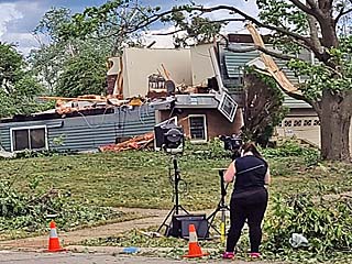
|
Destroyed home and news crew in Woodridge, Illinois. |
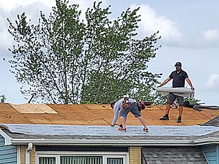
|
Temporary repairs being done to a roof in Woodridge, Illinois, before a blue tarp is put on. |
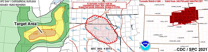
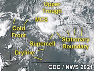
|
This is an annotated visible satellite image for around 22z during the afternoon of June 24. Severe storms can be seen over southern Nebraska in a complicated forecast scenario. A solitary supercell can be seen in northeastern Kansas, south of the messy severe storm (MCS) to the north. |
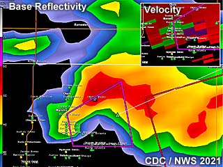
|
This is a base reflectivity radar image of a tornado-warned supercell northeast of Marysville, Kansas at roughly 6:00 PM CDT. The velocity of the supercell is shown in the inset to the upper-right. |
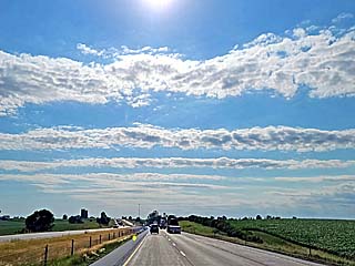
|
Horizontal convective rolls (HCRs) streaming across the sky in the low to mid levels during the morning of June 24 in Iowa. |
|
Altocumulus asperatus clouds streaming overhead in southwestern Iowa during the early afternoon, as the lead impulse of an upper wave moves in from the west. |
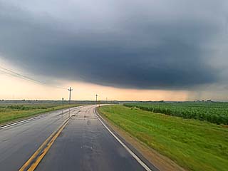
|
Approaching a developing supercell (note laminar updraft base) from the north near Marysville, Kansas. The view is to the south. |
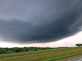
|
Rapidly intensifying supercell northwest of Marysville, Kansas. A slight hint of a developing RFD can also be seen just below the center of the picture. The view is to the northwest. |
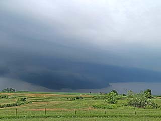
|
Large wall cloud forms on the supercell northeast of Marysville, Kansas as it is also issued a tornado warning. |
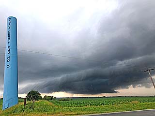
|
Rotating wall cloud and tagging rain curtains as the supercell passes north of Beatti, Kansas. The view is to the northwest from SR 99. |
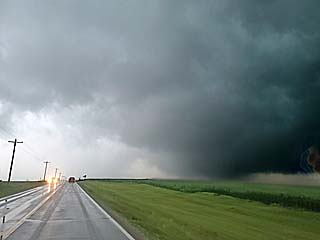
|
Large, rotating wall cloud, almost to the ground just east of SR 99 and north of Beatti, Kansas. The view is to the north. |
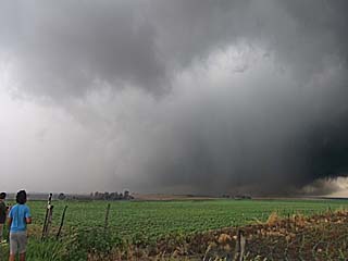
|
Powerful rotation (RFD in the foreground) east of SR 99 and north of Beatti, Kansas. The rapidly rotating wall cloud, just right of the center of the picture, is trying to form a large tornado here. The view is to the northeast. |
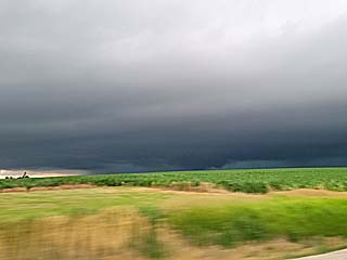
|
Large lowering along the leading edge of a storm complex west of Corning, Kansas as the supercell(s) become undercut by outflow. The cloud base is dark and menacing, as the mesocyclone is undercut by cooler air. The view is to the northwest. |
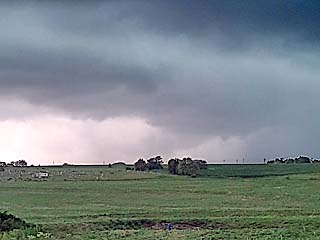
|
The storms weaken near Corning and Centralia, Kansas as they evolve to a messy, outflow domainant MCS of strong and severe storms by evening. The view is west and northwest at a weakening low-level mesocyclone. |
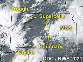
|
This is an annotated visible satellite image for around 23z during the early evening of June 25. Multiple storms can be seen over Kansas and adjacent areas, with a prominent boundary extending from SW to NE across the state providing low-level forcing for storms. |
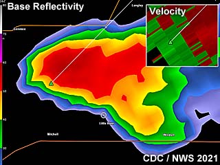
|
This is a base reflectivity radar image of a small supercell over Ellsworth County, Kansas just before 6:00 PM CDT. This was the left split of a storm much earlier near Reno County farher south. The subtle velocity of the supercell is shown in the inset to the upper-left. |
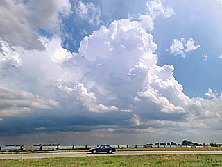
|
Convective initiation during the afternoon of June 25 over central Kansas. The view here is to the south and southeast on I-35 approaching Manhattan. |
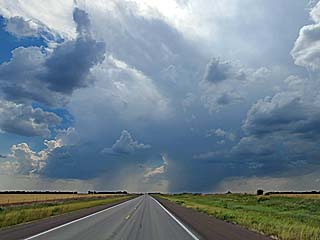
|
This is a view of two small LP supercells undergoing a storm split west of Hutchinson, Kansas over Reno county during the late afternoon. The view is to the west. |
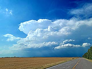
|
The left split of the two supercells above continued northeast and became the more intense storm due to weaker capping near Geneseo, Kansas. The view is to the north. |
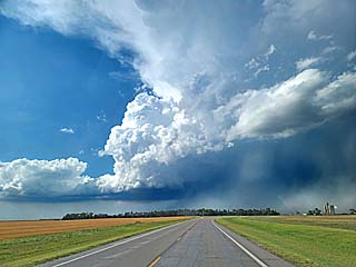
|
View of updraft base and left-split storm, well now well north of the original split, over Rice County, Kansas. The view is to the north. |
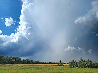
|
Hail core and hail shaft of the storm near Geneseo. Hail to golfball sized was encountered before this storm weakened. The view is to the northeast. |
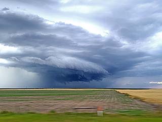
|
Severe thunderstorm / MCS north of I-70 east of Colby, Kansas during the early evening. |
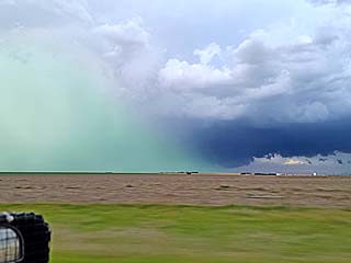
|
View of hail / rain-foot of the severe storm northeast of Colby, Kansas. |
|
June 26th through the 28th were travel days from Colorado to southern California, concluding the chase "expedition" since April 24. Here I am traveling through Colorado and across a ranch of cows in the foothills of the Rocky Mountains near Denver. |
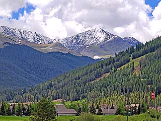
|
One of many beautiful views off I-70, which carves through the Rocky Mountains and Glenwood Springs and canyon, offering majestic views of the 14,000+ peaks of the Rockies. Snow still covers the mountains even in summer. |
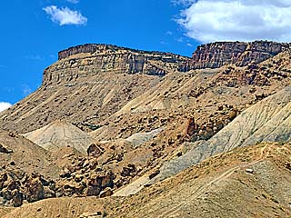
|
Past Colorado and Utah, the landscape changes dramatically, giving way to dry desert and plant-less cliffs, looking more like the surface of Mars than Earth. |
|
Passing through Nevada, with a stop for the night in Las Vegas before the final "push" into southern California the following day. |
|
Passing through the Mojave Desert. Here, a large thermometor display sits in Baker, California with temperatures approaching 115 degrees F. |
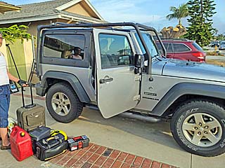
|
Back in southern California on June 28, and officially finishing the main chase trip. |
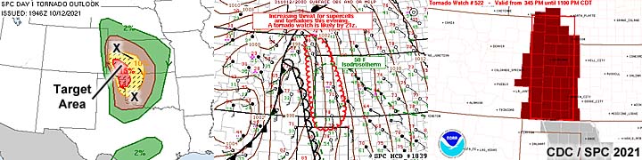
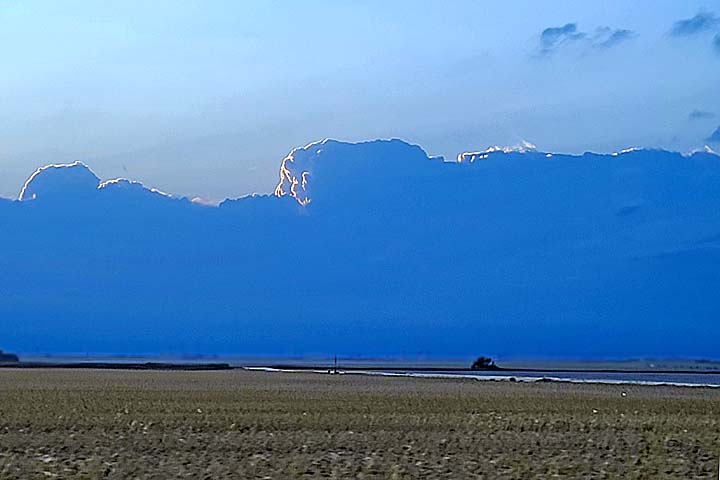
1). Oct 12, 8:30 PM - Observation and penetration of a severe thunderstorm along Highway 50 and near SR 27 in Hamilton County, Kansas and near Syracuse. This storm was part of a cluster of strong and severe thunderstorms, some with weak tornadoes and large hail. The worst parts of this storm cluster, using radar, were avoided due to it being at night and using a rental vehicle. Conditions encountered were frequent to continuous lightning, small hail (to dime sized), torrential rains, and winds gusting over 60 MPH. Copious amounts of marble sized hail was also was noted covering the ground north of Leoti later on along Highway 27. Conditions causing the storms were a strong upper-level low, surface low pressure, dryline / Pacific cold front, warm front, and surface heating. Documentation was digital stills. A 2021 Nissan Versa was used to chase these storms. A tornado watch was also in effect for the area until 11 PM CDT.
This concludes the chase log for the central United States and Midwest for ANY OTHER chases in 2021 not part of a special section (especially those for single-day "spot" chase trips). The summary includes a total of 1 observation, out of which there all was 1 severe thunderstorm. No tornadoes were observed in these trips, except for penetration of a dust devil in California. The main chase vehicle conducting these chases was a 2016 Jeep Wrangler and 2021 Nissan Versa (rental). This information was prepared exclusively for the National Weather service and the team of Skywarn storm spotters.
|
Dust devils are swirling updrafts resembling a mini tornado, but develop in dry conditions where a strong temperature gradient exists just above the ground (hotter near the ground). These are common in desert or dry regions with intense surface heating. Here is a picture of one developing in Lake Elsinore, California near the skydiving center there on July 18, 2021. The parachutist in the foreground is not in danger. |
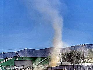
|
Another intense dust devil forms in Lake Elsinore, California during the hot afternoon of July 18, and works its way into a small industrial area. The chase is on! I am going to run after it! |
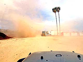
|
View of dust devil entering dry work lot. I am driving towards it. |
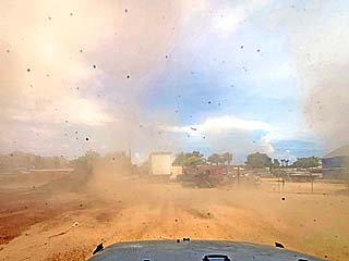
|
Inside the dust devil! Swirling air (around 60 MPH) with lots of dust. Can you spot the "core" flow? |
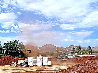
|
Dust devil lifts, picking up some trash and debris along the way. See the video links above for a short video (dash-cam) of this encounter! |
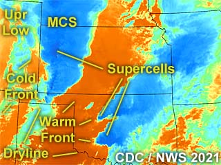
|
This is an annotated colorized (infrared channel) satellite image around 2z on October 13 (around 8 PM on October 12) showing the synoptic environment and storm evolution. Two powerful supercells, developing well away from the main areas of highest probabilities as per the SPC (Storm Predictions Center), are in SW Oklahoma. The southern storm in Oklahoma produced a significant tornado after dark. In SW Kansas, the highly feared long-track tornadic storms did not develop. After dark, a cluster of severe storms extended from NW Kansas southward to east of the OK / KS CO tri-state region. A weak tornado was produced after dark near Sharon Springs in west-central to NW Kansas as well. |
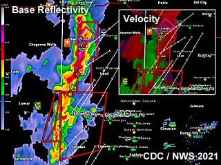
|
This is a radar image of the storms over west-central Kansas at around 8 PM CDT on October 12. The main image is the base-reflectivity showing the approaching MCS and embedded supercell south of Sharon Springs to the north (and the pink polygon is a tornado warning area). The upper=right inset shows any Doppler velocities in these storms. Radar is from Dodge City, Kansas (KDDC). |
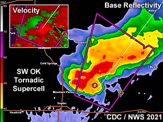
|
Although not applicable to this storm chasing target area, this is a radar image of the tornadic supercell over SW Oklahoma (250 miles away from me) at about the same time, between 8:30 and 9 PM CDT. A far more impressive supercell structure is presented in the base-reflectivity product (radar is KFDK - Frederick, OK), with a powerful Doppler velocity signature denoted in the upper-left inset. This storm has already produced a large tornado after dark near Snyder, Oklahoma. |
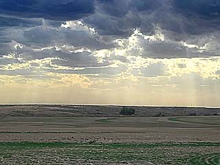
|
View looking towards the southwest from just north of Syracuse, Kansas. The dryline boundary can be seen sharpening to the southwest by late afternoon, with clearing sky behind it, and agitated cumulus developing in the foreground. |
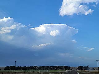
|
View looking northwest between Syracuse and Leoti, Kansas. The Pacific cold front, oriented SW to NE is beginning to overtake the dryline as it stalls late in the day. A thunderstorm and anvil is visible as storms initiate. A subtle warm front is also arching eastward out of this area. |
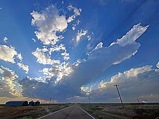
|
The atmosphere remained capped until after dark ahead of the slowing dryline. In this picture, a "turkey tower" updraft attempts to go up near Leoti, Kansas, and quickly gets toppled over by over 100 knots of speed / directional wind shear (very strong winds aloft). The view is to the west. |
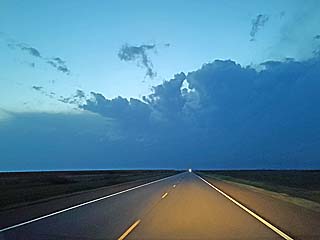
|
Developing squall line and MCS (cluster of strong and severe storms) over western Kansas after sunset. The view is to the west from west of Garden City. |
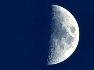
|
Beautiful half moon shining through the clear and capped air mass near Garden City, Kansas after dusk. |
HTML File "mwcl2021.htm" - Developed By Chris Collura
To Return To The HOME Page Of This Site Click The "INDEX.HTM" Link Here!