
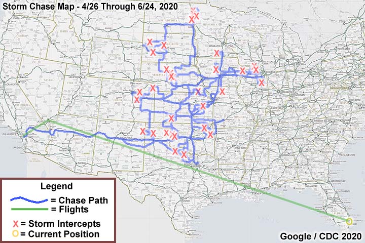
| This section is for storm chases done in the central / Midwestern United States during the year of 2020. This includes all storm chasing activities (including any major chase "expeditions") during the year of 2020 in the central USA (aka "Tornado Alley"). For 2020, all chases in the central USA will be logged in this section, with many of the chases being possible "spot" chases / major severe weather "setups" chased. Here you should find many pictures of lightning, tornadoes, hail, strong winds, along with many severe thunderstorm elements. Keep in mind that this chase log is scientific evidence and portrays my on-going storm chasing research. It has been placed on this page for easy reference and meteorological interests. Please do not plagiarize or copy this document to other sites for distribution. Note - This page may take a while to load on some SLOWER connections! |
STORM CHASING - CENTRAL UNITED STATES - 2020 CHASE LOG
| CHASER NAME | HOME / BASE CITY | CALLSIGN | CHASE DATES | OCCUPATION |
| CHRIS COLLURA | GARDEN GROVE, CA | KG4PJN | 4/26 TO 6/24 | IT CONSULTANT |
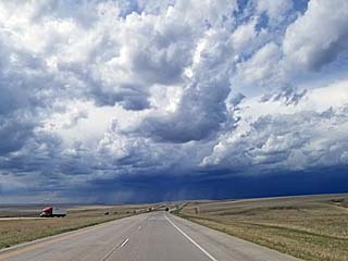
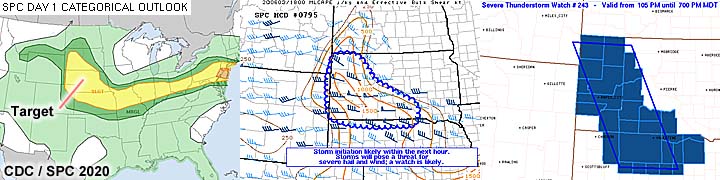
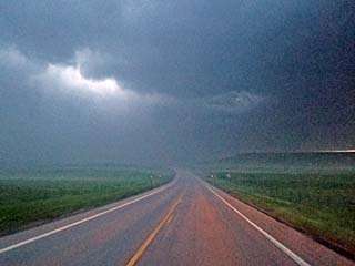
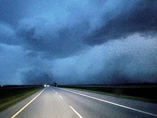
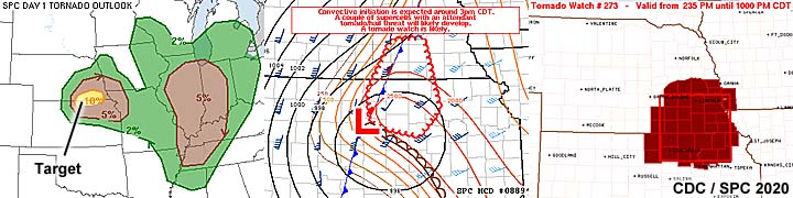
1). Apr 28, 6:00 PM - Observation and penetration of severe thunderstorms from north of Bartlesville, Oklahoma, and southward past Tulsa to near Henryetta, mainly from near Highways 75 and 60, and southward along Highway 75 to near SR 72 and Highway 62. The storms were a fast moving multicell cluster of strong and severe thunderstorms, with some embedded HP supercells. One of these storms produced a funnel cloud over Tulsa, observed from near SR 52 and Highway 169 in Tulsa County. Hail to 1", frequent lightning (with some close hits), heavy rains, and winds gusting over 60 MPH were observed with these storms. Conditions causing the storms were a strong upper trough, surface heating / convergence, a cold front, and low pressure trough. Documentation was digital stills and HD video. A 2016 Jeep Wrangler was used to chase the storms. A tornado watch was also in effect for the area until 11 PM CDT.
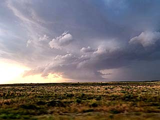
2). May 2, 7:30 PM - Observation of strong thunderstorms from near and east of Denver International Airport from along I-70 in eastern Denver County. The storm was a multicell cluster of strong thunderstorms. The core was not penetrated, which contained small hail. Frequent lightning was also observed, as well as a possible small funnel. The southern end of this storm complex had a small supercell thunderstorm, which was also observed from a distance looking to the southeast. Conditions causing the storms were surface heating, up-slope wind flow, and an upper trough. Documentation was digital stills. A 2016 Jeep Wrangler was used to chase the storms.
3). May 3, 7:00 PM - Observation and indirect penetration of a severe thunderstorm to the west and southwest of Wray, Colorado in Yuma County, and along Highway 34. The storm was a cluster of strong and severe storms, originally spawned by convective up-slope near the Palmer Divide west of Limon, that moved northeast off the higher elevations. One intense storm was warned for quarter sized hail and 60 MPH winds, but the core was not penetrated directly. Conditions encountered were 40 MPH winds, rain, small hail, and occasional lightning. Conditions causing the storms were surface heating, up-slope wind flow, and an upper trough. Documentation was digital stills. A 2016 Jeep Wrangler was used to chase the storms.
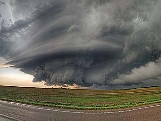
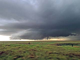
4). May 4, 6:30 PM - Observation and penetration of a very severe, and possibly tornadic thunderstorm in Mayes County, Oklahoma, from near Foyil, and through Pryor to Salina, mainly near Highway 69 and SR 20. The storm was an HP supercell storm. A large, rotating wall cloud, with occasional funnels, was noted with this storm, which became rain-wrapped at times. The storm also had a striated appearance and inflow bands when viewed from the east. Frequent lightning was also encountered, including numerous close hits with powerful positive smooth-channel lightning. Large hail, up to 2", was also noted, with large pieces splashing into Hudson Lake near Salina. Winds gusting over 50 MPH and heavy rain was also noted with this storm. Conditions causing the storms were surface heating, a low pressure area, cold front, and an upper trough. Documentation was HD video, digital stills, and audio. A 2016 Jeep Wrangler was used to chase the storms. A tornado watch as also valid for the area until 10 PM CDT.
5). May 7, 6:00 PM - Observation and direct penetration of an extremely severe and possibly tornadic thunderstorm from northwest of Childress, Texas in Childress County near Highway 287 and southeastward to near Newcastle and Highway 380 in Young County. The storm was a powerful classic and HP supercell storm, initiating to the NW of Childress, with a distinct storm split (the southern, right-moving supercell being the main storm). Conditions encountered with this storm were 60 to 70 MPH winds, frequent lightning, and hail to baseball sized. This storm caused extensive hail damage along the path of its hail swath. A few brush fires were also started from lightning, with smoke noted interacting with the airflow around the core of the supercell. This supercell also had a striking visual appearance, with a "mothership" / stacked-plates presentation. The chase vehicle had hail guards covering the windows, with damage mainly large dings to the hood. Some funnels were also observed, with one large one, possibly a brief tornado, observed to the NW of Seymour while still in baseball sized hail looking southwest. Conditions causing the storms were surface heating, a low pressure area, dryline, and an upper trough. Documentation was HD video, digital stills, and audio. A 2016 Jeep Wrangler was used to chase the storms. A severe thunderstorm watch as also valid for the area until 10 PM CDT.
6). May 13, 4:30 PM - Observation of a strong to severe thunderstorm northwest of Canadian, Texas in Hemphill and Lipscomb Counties near Highway 60. The storm was an LP supercell. The core (probably with 1" hail) was not penetrated. Some lightning was also observed. Conditions causing the storms were surface heating, a low pressure trough, dryline, and an upper trough. Documentation was HD video (including a time-lapse) and digital stills. A 2016 Jeep Wrangler was used to chase the storms. A severe thunderstorm watch as also valid for the area until 10 PM CDT.
7). May 13, 6:00 PM - Observation of a severe thunderstorm near Sweetwater, Oklahoma in Cheyenne and Beckham Counties near SR 152 / 6. The storm was a small classic supercell. The core was indirectly penetrated during its earlier stages and quarter sized hail was encountered briefly. Some rain and lightning was also observed. Conditions causing the storms were surface heating, a low pressure trough, boundary interactions, and an upper trough. Documentation was HD video and digital stills. A 2016 Jeep Wrangler was used to chase the storms. A severe thunderstorm watch as also valid for the area until 10 PM CDT.
8). May 13, 7:00 PM - Observation and indirect penetration of a severe thunderstorm near Sayre, Oklahoma in Backham County near SR 152. The storm was a small classic supercell, with a distinct left and right split. The core (with 1.5" hail reported) was not directly penetrated. Some lightning was also observed, with rain, 60 MPH winds, and small hail. Conditions causing the storms were surface heating, a low pressure trough, boundary interactions, and an upper trough. Documentation was HD video (including a time-lapse) and digital stills. A 2016 Jeep Wrangler was used to chase the storms. A severe thunderstorm watch as also valid for the area until 10 PM CDT.
9). May 14, 6:00 PM - Observation and indirect penetration of a severe thunderstorm north of Emporia and SW of Americus, Kansas in Lyon and Morris Counties near SR 99. The storm was a small classic supercell storm that undergone down-scaling and split, with the right split intensifying and becoming the main storm. The storm core was indirectly penetrated, and hail up to 1" was observed. Heavy rains, lightning, and 35 MPH winds were also encountered. The storm also had a striking visual appearance, with a tilted "barber pole" updraft, flared "bell shaped" base, and rotating wall cloud / RFD cut. Some small funnels were also observed with this storm before it cycled down and weakened. Conditions causing the storms were surface heating, a low pressure trough, pre-frontal convergence, and an upper trough. Documentation was HD video and digital stills. A 2016 Jeep Wrangler was used to chase the storms. A severe thunderstorm watch as also valid for the area until 12 AM CDT the next day.
10). May 15, 6:00 PM - Interception and Observation of a severe thunderstorm near Calhan, Colorado in El Paso County, and near SR 94 and Highway 24. The storm was a classic supercell storm, developing on the Colorado Palmer Divide. An area of strong rotation, with a pronounced wall cloud and RFD cleat slot was noted with this storm. A few small funnels were also observed. The core of the storm, containing golfball sized hail, was not penetrated. Frequent lightning, 30 MPH winds, and light rain were observed to the south of the storm core. The storm also had a striking visual appearance, with striations and inflow banding. Conditions causing the storms were surface heating, a low pressure trough, up-slope wind flow, and an upper trough. Documentation was time-lapse video and digital stills. A 2016 Jeep Wrangler was used to chase the storm.
11). May 17, 5:30 PM - Interception and penetration of a strong thunderstorm near Forrest, Illinois in Livingston County, and near SR 47 and Highway 24. The storm was a mart of an extensive cluster of strong and severe thunderstorms, mainly in a line. An area of rotation was noted with this storm, with a brief funnel, wrapping in rain. The storm also produced occasional lightning, very heavy rains, and winds gusting near 50 MPH. Severe flash flooding was also observed with these storms. Conditions causing the storms were limited surface heating, a low pressure area, cold / warm front interactions, and an upper trough. Documentation was HD video and digital stills. A 2016 Jeep Wrangler was used to chase the storm. A severe thunderstorm watch as also valid for the area until 10 PM CDT.
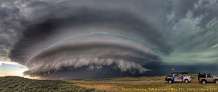
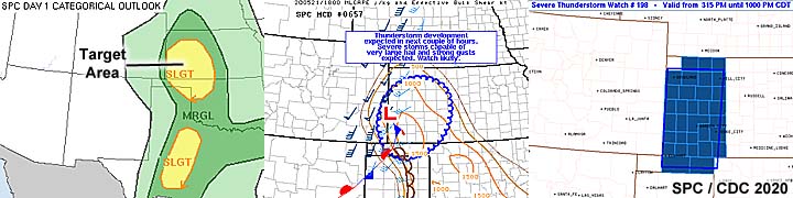
12). May 21, 5:30 PM - Interception and observation a very severe thunderstorm west of Syracuse, Kansas, along Highway 50 in Hamilton County. The storm was a powerful HP supercell undergoing evolution to a line segment, and merged with a smaller LP supercell just its east near Kendall. Some brief (small land-spout) tornadoes were reported with this storm earlier, but were not directly observed. The storm contained baseball sized hail and 70 MPH winds, but the core was not penetrated. Winds near 50 MPH, small hail, frequent lightning, and heavy rain were observed with this storm. The storm had both a wall cloud and impressive gust front / shelf cloud during its outflow stages. Conditions causing this storm were surface heating, a low pressure area, cold front, and an upper trough. Documentation digital stills. A 2016 Jeep Wrangler was used to chase the storm. A severe thunderstorm watch as also valid for the area until 10 PM CDT.
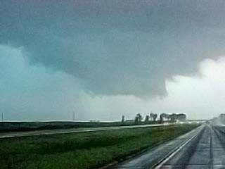
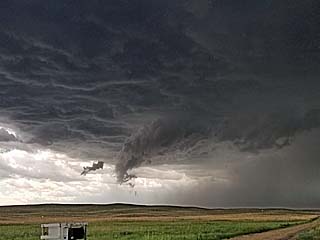
13). May 21, 7:00 PM - Interception, observation, and penetration an extremely severe and tornadic thunderstorm between Ulysses and Lakin, Kansas, along SR 25 in Kearney County. The storm was a large HP supercell storm, and had an extreme visual appearance south of Lakin during its intense stages, with multiple "stacked-plates" or "mothership" presentation. A rotating wall cloud was noted on the NE side of the storm, with strong inflow to 50 MPH, and RFD kicking up dust. Some funnels were also observed, and a brief tornado (not intercept) was later reported as the storm weakened towards Garden City. Conditions encountered were frequent lightning, winds over 70 MPH, hail up to golfball sized, and torrential rains. The penetration of the storm was through the wet RFD region, avoiding the larger hail to the north with the forward flank of the storm. Conditions causing this storm were surface heating, a low pressure area, dryline / boundary interactions, and an upper trough. Documentation digital stills and HD video. A 2016 Jeep Wrangler was used to chase the storm. A severe thunderstorm watch as also valid for the area until 10 PM CDT.
14). May 21, 8:30 PM - Interception, observation, and penetration another very severe and possibly tornadic thunderstorm near Satanta and Sublette, Kansas, from near Highway 83 in Haskell County. The storm was a supercell storm going from LP to Classic, and ultimately HP in a complex evolution. This storm also had an impressive visual presentation, with multiple "stacked-plates" or a "mothership" appearance when viewed from a truck stop near Sublette. A rotating wall cloud was noted with a large funnel. Tornado touchdown could not be confirmed due to low light. Very strong inflow exceeding 50 MPH was noted with this storm, with some papers and light debris being pulled towards the storm. The RFD presented a wind shift, and contained winds over 70 MPH, which was penetrated during the later stages of the storm. Other conditions encountered were frequent lightning, hail to 1", and torrential rains. The main core was not penetrated. Conditions causing this storm were surface heating, a low pressure area, dryline / boundary interactions, and an upper trough. Documentation was digital stills and HD video (including a storm time-lapse). A 2016 Jeep Wrangler was used to chase the storm. A severe thunderstorm watch as also valid for the area until 10 PM CDT.
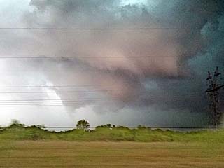
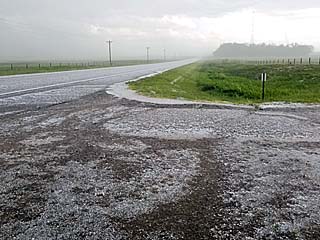
15). May 22, 6:30 PM - Observation and indirect penetration of an extremely severe and tornadic thunderstorm from near Davidson, Oklahoma in Tillman County near Highway 70, and southeastward through Burkburnett, Texas near I-44 and SR 79, until near Petrolia in Clay County. The storm was a classic to HP supercell storm. At least one weak tornado, with a funnel and rotating wall cloud, with ground contact denoted by dust, was observed during the early stages of the storm. This thunderstorm produced extremely large hail, possible record-setting, with pieces crashing through roofs of homes, especially near Burkburnett. Powerlines down and wind damage was also noted in Clay County east of Shepard Air Force Base. This storm also had an impressive "stacked-plates" visual appearance. The core of this storm was not directly penetrated, although hail exceeding baseball sized was observed. The storm also developed a well-defined RFD, with a distinct clear slot and winds gusting to near 80 MPH. A smaller second tornado was observed as well off FM 171. In addition to extremely large hail and weak tornadoes, winds gusting near 80 MPH, frequent lightning (with close hits), and torrential, horizontal rains were also observed. Conditions causing the storms were surface heating, a low pressure area, outflow boundary / dryline interactions, and an upper trough. Documentation was digital stills, audio, and HD video. A 2016 Jeep Wrangler was used to chase the storm. A severe thunderstorm watch as also valid for the area until 8 PM CDT.
16). May 23, 4:30 PM - Interception, observation, and penetration of a very severe and tornadic thunderstorm from near Pecatonica in Winnebago County, Illinois by Highway 20, and points northeastward to near Beloit and Clinton, Wisconsin in Rock County near I-39 and I-43. The storm was a small classic to HP supercell storm. At least two weak tornadoes were observed with this supercell thunderstorm, one northwest of Rockford, IL, and another west of Clinton, WI. The latter became rain wrapped quickly. Torrential rains, 65 MPH winds, occasional lightning, and small hail was also encountered with this storm. Conditions causing the storm were surface heating, a low pressure system, warm front, convergence line, and upper trough. Documentation was digital stills and HD video. A 2016 Jeep Wrangler was used to chase the storm. A tornado watch as also valid for the area until 8 PM CDT.
17). May 23, 6:30 PM - Penetration of a severe, and possibly tornadic, thunderstorm in McHenry County, Illinois to the east of Marengo along Highway 20. The storm was an HP supercell storm embedded in a line segment of strong and severe thunderstorms. A strong rotation signature was evident on radar, but just shifting, strong winds were observed east of Marengo. The storm was completely rain wrapped, with a brief glimpse of a rotating wall cloud / rapidly up-drafting scud on the eastern edge of the storm. Conditions encountered were occasional lightning, 60 MPH winds, torrential rains, and small hail. Conditions causing the storms were surface heating, a low pressure system, warm front, convergence line, and upper trough. Documentation was digital stills and HD video. A 2016 Jeep Wrangler was used to chase the storm. A tornado watch as also valid for the area until 8 PM CDT.
18). May 24, 4:00 PM - Interception and penetration of a severe thunderstorm near Jamesport, Missouri in Daviess County, and near Highway 65, and SR 6 and B. The storm was a brief HP supercell storm, developing at the end of a line segment. The storm had a rotating wall cloud before quickly becoming undercut by outflow. The storm evolved into a multicell storm cluster, then a line by late afternoon as it was followed north and east toward near Spickard. Conditions encountered were small hail, 60 MPH winds, torrential rains, and lightning. The main core was not penetrated during the intense stages of the storm, and contained hail to half-dollar sized. Conditions causing the storms were surface heating, a low pressure trough, warm front, convergence line, and upper trough. Documentation was digital stills. A 2016 Jeep Wrangler was used to chase the storm. A severe thunderstorm watch as also valid for the area until 8 PM CDT.
19). May 25, 6:00 PM - Observation of a strong thunderstorm from Highway 30 east of Cedar Rapids, Iowa in Linn County. The storm was a brief supercell that evolved to a multicell cluster and down-scaled. The core was not penetrated, but a brief funnel, about 1/3 way to the ground, was noted on the southern side of this storm. Conditions causing the storms were a surface heating, a weakening low pressure area, convergence, and weak upper trough. Documentation was digital stills. A 2016 Jeep Wrangler was used to chase the storm.
20). May 26, 3:00 PM - Interception, observation, and penetration of severe and tornadic thunderstorms in a cluster from northwest of Des Moines, Iowa near Dallas County and Highway 169, and northward to near Goldfield in Humboldt County and SR 6 / I-35. The storm cluster contained areas of intense low level rotation, with embedded classing / HP mini supercells. Three tornadoes were observed with these storms, one west of Granger, another near Ogden, and one north near Goldfield. Other conditions encountered were torrential rains, occasional lightning, small hail, and 60 MPH winds. No damage was observed, as any tornadoes remained over open rural areas and were not long lasting. Conditions causing the storms were a surface heating, a low pressure area, shear / confluence axis, and upper trough. Documentation was digital stills and HD video. A 2016 Jeep Wrangler was used to chase the storm. A tornado watch was also valid for the area until 8 PM CDT.
21). June 2, 5:00 PM - Observation and penetration of a very severe and possibly tornadic thunderstorm from southwest of Mankato, Minnesota in Blue Earth County and Highway 169, and south and east through Freeborn County and near Geneva an I-35 / SR 30. The storm was a powerful classic supercell storm (on the eastern part of a cluster of strong and severe storms) that evolved to HP, and eventually a bow segment. This supercell storm was documented during its entire life-cycle, from initiation (out of a TCU field west of Mankato) to evolution to a bow segment near Geneva. The storm produced large hail to tennis ball sized (although when the core was penetrated, hail to 2" was observed), lightning, torrential rains, and winds exceeding 75 MPH. Some funnels and gustnadoes, with one dust cloud observed under a funnel / wall cloud (possible tornado) north of Mapleton. The storm caused damage to powerlines, and trees were observed being blown over. Some semi-trucks were also noted overturned on I-35 north of Albert Lea and near Geneva. The storms were caused by surface heating, a weak low pressure area, nearly stationary frontal boundary, and an upper trough. Documentation was digital stills, HD video, and audio. A 2016 Jeep Wrangler was used to chase the storm. A severe thunderstorm watch was also valid for the area until 12 AM CDT.
22). June 3, 4:30 PM - Interception, observation, and indirect penetration of a severe thunderstorm in Cherry County, Nebraska near Highway 83. The storm was a classic supercell storm, which split and evolved into a multicell storm cluster. The storm had hail up to 2", and during an indirect penetration of the south side of the storm core, hail to 1" was observed, covering the ground. The storm also contained lightning, heavy rains, and winds exceeding 70 MPH. A rotating wall cloud was also observed before the storm became undercut and outflow dominant. The storms were caused by surface heating, a low pressure trough, and an upper trough. Documentation was digital stills and HD video. A 2016 Jeep Wrangler was used to chase the storm. A severe thunderstorm watch was also valid for the area until 7 PM MDT (8 PM CDT).
23). June 4, 5:30 PM - Interception, observation, and penetration of a severe thunderstorm from near Faith, South Dakota in Meade County and SR 73 and southeastward near and south of the Cheyenne Indian Reservation along SR 34. The storm was a long-track, classic to HP supercell storm that became outflow dominant and evolved to a bow segment before weakening near I-90 SW of Pierre. The storm was mostly observed externally during the long-range intercept. Once encountering the storm, strong winds over 60 MPH, heavy rains, lightning, and hail to 1" was encountered. The storm core had hail to baseball sized earlier, before it was penetrated. The storm also had a low wall cloud and RFD clear slot, but was undercut by outflow. Conditions causing the storm were surface heating, a stationary frontal boundary, low pressure trough, and upper trough. Documentation was digital stills. A 2016 Jeep Wrangler was used to chase the storm. A severe thunderstorm watch was also valid for the area until 10 PM MDT (11 PM CDT).
24). June 4, 8:00 PM - Observation of a severe thunderstorm south of Wall, South Dakota, mainly over Pennington County and near Interior from I-90. The storm was a classic supercell storm that passed over the eastern part of Rapid City earlier as an HP storm with a large swath of hail left there. When the storm was observed, a large wall cloud and brief funnel was noted looking south from I-90. The storm core, over the Badlands National Park, was not penetrated. Lightning, light rain, and 40 MPH winds were also noted at my location. Conditions causing the storm were surface heating, a stationary frontal boundary, low pressure trough, and upper trough. Documentation was digital stills. A 2016 Jeep Wrangler was used to chase the storm. A severe thunderstorm watch was also valid for the area until 10 PM MDT (11 PM CDT).
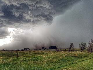
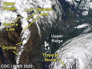
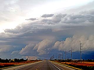
25). June 6, 8:00 PM - Observation and penetration of severe thunderstorms from Butte County, South Dakota near Newell and Highway 21, north and east to near SR 79 and Highway 12 in NE Perkins County. The storm was part of a large area of severe thunderstorms, most likely a derecho, in an extensive linear / bow MCS. The gust front and shelf cloud presented a striking visual appearance on the leading edge of this system. Conditions encountered were heavy rains, winds over 70 MPH, lightning, and small hail. Conditions causing the storm were surface heating, a low pressure area, surface trough, warm front, and upper trough. Documentation was digital stills and HD video. A 2016 Jeep Wrangler was used to chase the storm. A severe thunderstorm watch was also valid for the area until 1 AM MDT (12 AM CDT) the following day.
26). June 7, 5:30 PM - Interception and observation of a severe thunderstorm near Kennedy, Minnesota in Kittson County, and near Highway 75 and SR 20. The storm was a classic supercell that evolved into a line segment, and eventually pushed into Canada. For a while, a rotating wall cloud was observed with this storm, with a brief funnel. The core was not penetrated, but contained hail to quarter sized. Light rain, lightning, and 45 MPH inflow winds were observed with this storm. Conditions causing this storm were surface heating, a warm front, low pressure area, and upper trough. Documentation was digital stills and HD video. A 2016 Jeep Wrangler was used to chase the storm. A tornado watch was also valid for the area until 10 PM CDT.
27). June 7, 7:30 PM - Interception and penetration of a severe thunderstorm near Argyle, Minnesota in Marshall County, and along Highway 75. The storm was a small classic supercell. The storm was high-based and became undercut by cooler air ahead of the warm front. Hail to quarter sized, heavy rain, lightning, and 50 MPH winds were observed with this storm. Conditions causing this storm were surface heating, a warm front, low pressure area, and upper trough. Documentation was digital stills. A 2016 Jeep Wrangler was used to chase the storm. A tornado watch was also valid for the area until 10 PM CDT.
28). June 7, 8:00 PM - Interception and indirect penetration of a severe thunderstorm north of Alvarado, Minnesota in Marshall County, near SR 1 and SR 220. The storm was also a small classic supercell, which as also high-based and became undercut by cooler air east of the warm front / outflow from other storms. Small hail, heavy rain, lightning, and 50 MPH winds were observed with this storm. The core was not directly penetrated. Conditions causing this storm were surface heating, a warm front / outflow boundary interactions, low pressure area, and upper trough. Documentation was digital stills. A 2016 Jeep Wrangler was used to chase the storm. A tornado watch was also valid for the area until 10 PM CDT.
29). June 7, 9:30 PM - Penetration of severe thunderstorms along I-29 from Traill County, North Dakota near Buxton, and southward to Cass county north of Fargo. The storm was a powerful MCS of strong and severe thunderstorms. Blowing dust and small gustnadoes were visible on the leading edge of this multicell cluster / line of thunderstorms. Winds gusting over 70 MPH were encountered, with torrential rains, small hail, and frequent lightning. Conditions causing these storms were surface heating, boundary interactions, low pressure area, and upper trough. Documentation was digital stills and HD video. A 2016 Jeep Wrangler was used to chase the storms. A tornado watch was also valid for the area until 10 PM CDT.
30). June 8, 8:00 PM - Interception and observation of an extremely severe and tornadic thunderstorm near Arnold, Nebraska in Custer County, along SR 92 northwest of Broken Bow. The storm was a powerful HP supercell storm at the south end of a cluster of severe thunderstorms. The core of this storm was not penetrated, and contained hail exceeding 2" with strong winds. Inflow winds over 50 MPH were encountered with a rotating wall cloud, and broad tornado under the rotating portion of the supercell. A loud hail roar was also audible, and frequent lightning was also observed, with some close hits. The supercell had an impressive visual presentation, with striations and inflow banding, and "stacked plates" appearance. The storm remained over open areas and did little damage. Conditions causing the storm were surface heating, a low pressure trough, stationary frontal boundary, and upper trough. Documentation was digital stills and HD video. A 2016 Jeep Wrangler was used to chase the storm. A severe thunderstorm watch was also valid for the area until 2 AM CDT the following day.
31). June 9, 6:00 PM - Observation of severe thunderstorms from near Bellview, Kansas in Washington County along Highways 81 and 36, and eastward to north of Marysville, and eventually to near Falls City, Nebraska near Highway 73 in Richardson County. The storms were a broken line of severe thunderstorms, along a confluence arc, extending east and southeast from a surface low over Kansas. Some of these storms were small classic supercells. The cores were not penetrated, and two small funnels were observed. One of these cells near Marysville produced a funnel (not observed) that was reported as a brief tornado (unconfirmed). Some lightning, rain, and 40 MPH winds were otherwise encountered, with small hail noted on the side of the road behind the storms. Conditions causing the storm were surface heating, a low pressure area, convergence line, cold front, and upper trough. Documentation was digital stills. A 2016 Jeep Wrangler was used to chase the storm. A tornado watch was also valid for the area until 10 PM CDT.
32). June 20, 5:00 PM - Interception, observation, and indirect penetration of an extremely severe and tornadic thunderstorm in Blaine County, Nebraska from north of SR 91 near Dunning, Halsey, and Purdum. The storm was a powerful classic supercell developing in the northwest flow aloft. The storm had winds over 60 MPH, large hail (to baseball sized), frequent lightning, and heavy rains. At least two brief tornadoes were also observed with this storm, one between Halsey and Purdum, and another northeast of Dunning. Hail between 1.5" and 2" was also noted in the road northeast of Dunning. The core was only indirectly penetrated. No damage was observed since the main part of the storm remained over rural areas. This supercell had a striking visual appearance as well, with a pronounced RFD clear slot, and multiple striations on the updraft tower. Conditions causing the storm were surface heating, a low pressure area, convergence line, and upper trough (NW flow aloft). Documentation was digital stills and HD video. A 2016 Jeep Wrangler was used to chase the storm. A severe thunderstorm watch was also valid for the area until 10 PM CDT.
33). June 20, 7:00 PM - Interception, observation, and indirect penetration of a very severe thunderstorm in Custer County, Nebraska along SR 2 between Oconta and Callaway. The storm was a powerful classic supercell that evolved to LP (low precipitation), and eventually dissipated via down-scaling. Conditions encountered were 50 MPH winds (mainly RFD), light rain, lightning, and hail up to golfball sized. The storm produced some small funnels, one about half way to the ground. This supercell had a very striking visual appearance as well, with a pronounced RFD clear slot, and "stacked-plates" appearance of the updraft with a "mother ship" presentation when viewed just ahead of it. When the storm evolved to LP and weakened, a highly-sheared, multiple striation "barber pole" appearance was noted. Conditions causing the storm were surface heating, a low pressure area, convergence line, and upper trough (NW flow aloft). Documentation was digital stills and HD video. A 2016 Jeep Wrangler was used to chase the storm. A severe thunderstorm watch was also valid for the area until 10 PM CDT.
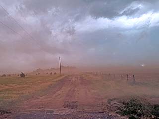
34). June 21, 6:00 PM - Interception and observation of severe thunderstorms from near Dodge City, Kansas in Ford County and along Highways 283 and 54, and southward to near Liberal near the KS / OK border in Seward and Beaver counties. The storms were a multicell cluster of severe storms, with some embedded supercells, and mostly outflow dominant. A "tail-end" supercell was encountered northeast of Liberal as well. Strong winds near 65 MPH, with lots of dust, frequent lightning, and light rain was observed. The hail cores of the storms were not penetrated. The dust raised by the gust front of the storm complex also created a haboob of dust. Conditions causing the storm were surface heating, a low pressure area, dryline / stationary front, and upper trough. Documentation was digital stills and HD video (time-lapse). A 2016 Jeep Wrangler was used to chase the storm. A severe thunderstorm watch was also valid for the area until 10 PM CDT.
35). June 22, 5:30 PM - Interception and indirect penetration of a severe thunderstorm in Union and Harding Counties, New Mexico near SR 102 / 402. The storm was a high-based severe thunderstorm, and briefly attained HP supercell mode before evolving into a cluster of storms. Very heavy rains, small hail, frequent lightning with some close hits, and 60 MPH winds were encountered. The core of the storm, with golfball sized hail, was not directly penetrated. Conditions causing the storm were surface heating, a low pressure trough, up-slope wind flow, and upper trough. Documentation was digital stills. A 2016 Jeep Wrangler was used to chase the storm. A severe thunderstorm watch was also valid for the area until 11 PM CDT.
36). June 22, 7:00 PM - Interception and indirect penetration of a very severe and possibly tornadic thunderstorm in Sherman and Moore Counties, Texas, northeast of Dumas and near Highway 287 and Ranch 281. The storm was a powerful HP supercell storm. The core of this storm, with hail up to baseball sized, was not directly penetrated. This supercell eventually was undercut by outflow, but had a dramatic visual appearance, with a "stacked plates" base and striations above it. A large wall cloud was also observed, with a gustnado / brief, dusty weak tornado observed southwest of Sunray. Other conditions encountered were 70 MPH winds, heavy rains, frequent lightning with close hits, and hail to 1". Some tree / sign damage was noted in Dumas, and a trailer overturned with emergency crew on scene south of Dumas off Highway 287. Conditions causing the storm were surface heating, a low pressure trough, boundary interactions, and upper trough. Documentation was digital stills. A 2016 Jeep Wrangler was used to chase the storm. A severe thunderstorm watch was also valid for the area until 11 PM CDT.
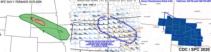
This concludes the chase log for the central US Plains for the main chase "expedition" of 2020 starting April 26 and ending on June 24. The summary includes a total of 36 observation(s), out of which there were 33 severe thunderstorms and 3 strong thunderstorms. Out of these thunderstorms, as many as 14 possible tornadoes were observed, although most of these were weak and brief. A 2016 Jeep Wrangler vehicle was used in all of the chases / observations above, logging a total of 22,721 miles. All entries for the logs above are for the local time zone unless otherwise noted. This information was prepared exclusively for the National Weather service and the team of Skywarn storm spotters.
|
Heading out of California and across Arizona on April 26. This was the first day of the main chase trip of 2020. |
|
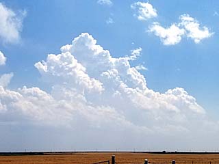
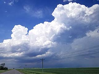
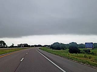
View of distant high-based cumulus developing on the north side of a moisture axis over SW Texas. The view is SE from near Clovis, New Mexico on April 27. Chasing was not done, since deeper convection was too far south to intercept (south of Fort Stockton / Mexico). |
|
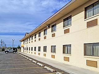
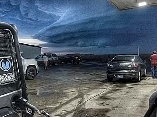
View of parking lot at the motel (Super 8) in Amarillo during the afternoon of April 27. Contrary to fears of COVID-19, social distancing obviously should be easy at such un-crowded hotels and areas! |
|
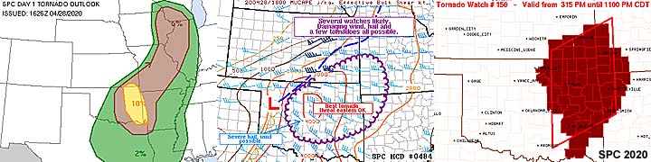
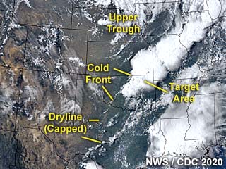
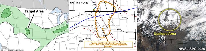
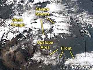
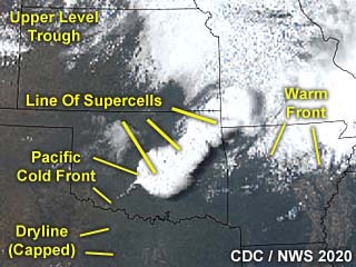
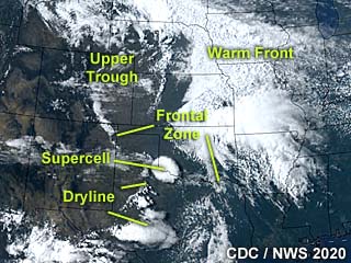
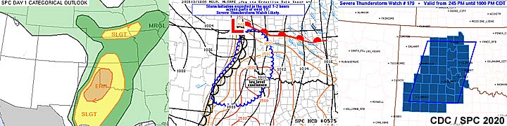
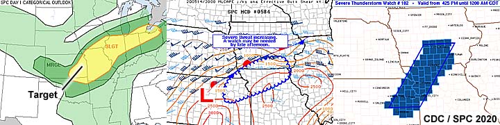
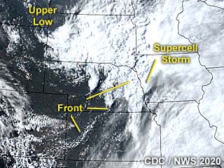
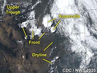
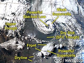
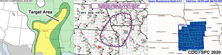
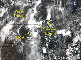
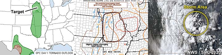
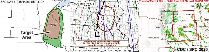
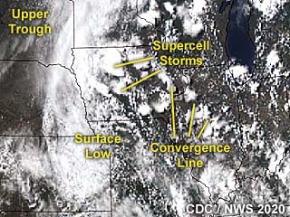
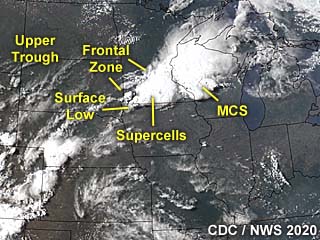
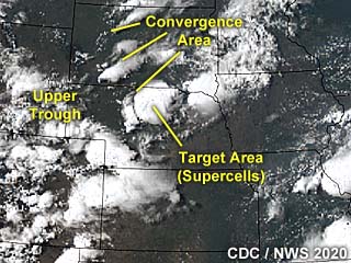
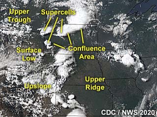
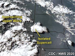
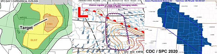
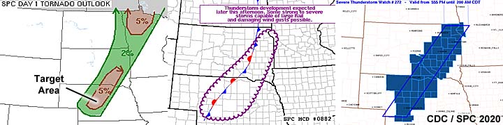
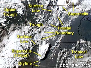
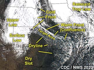
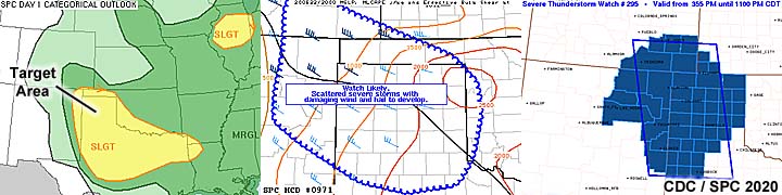
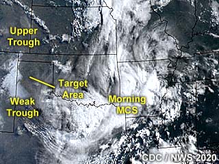
Annotated visible satellite image of storms developing across northeastern Oklahoma around 23z on April 28. The chase target area is in the northeastern portion of the state north of Tulsa, and is in the northwest flow aloft ahead of the upper wave to the north. |
|
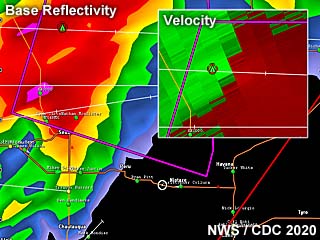
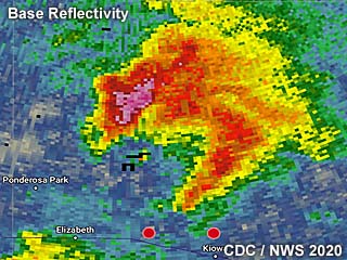
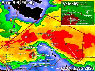
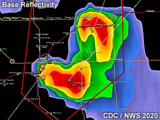
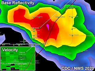
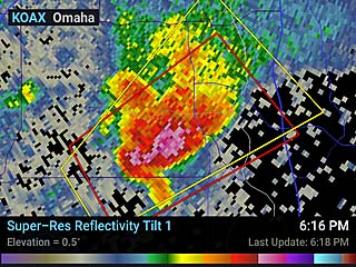
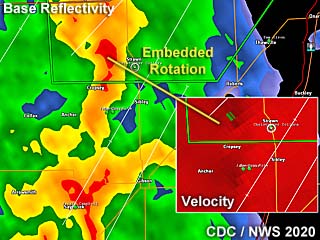
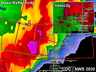
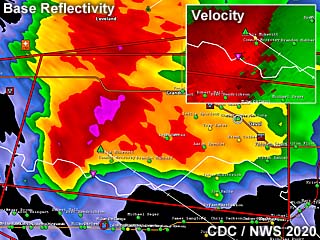
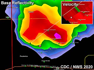
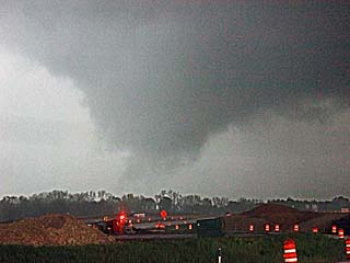
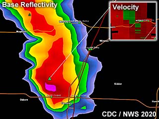
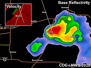
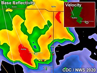
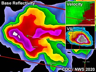
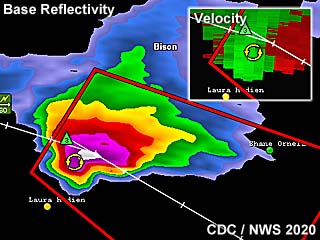
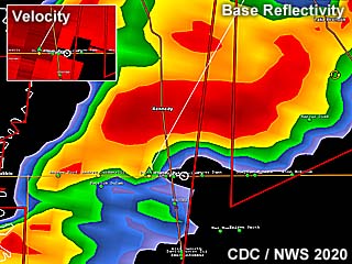
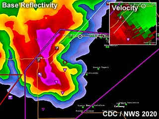
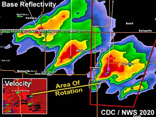
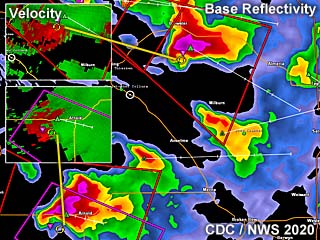
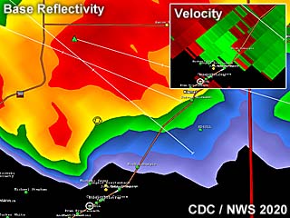
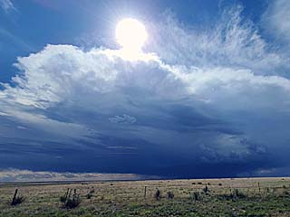
Radar image (base reflectivity, and Doppler velocity inset) of a tornado-warned storm in a cluster of severe storms over northeastern Oklahoma late in the afternoon of April 28. The inset (velocity) shows the broad rotation of the HP supercell. |
|
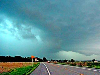
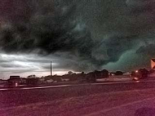
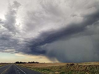
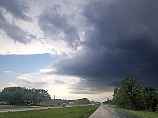
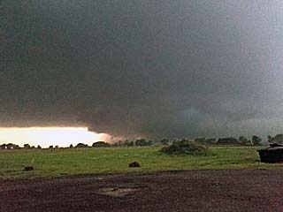
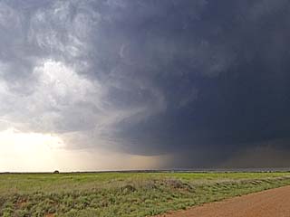
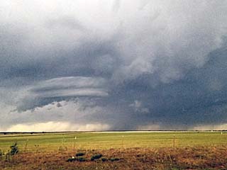
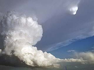
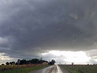
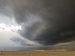
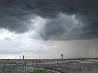
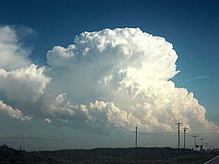
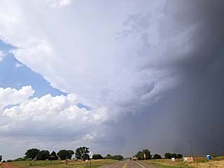
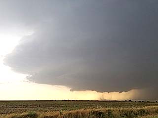
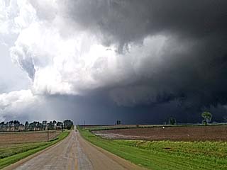
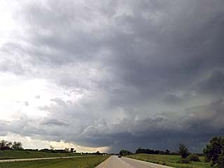
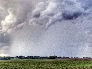
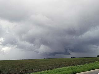
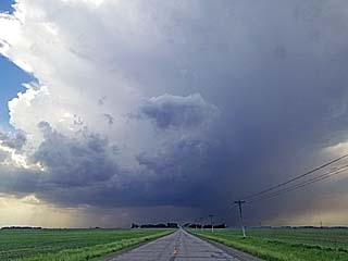
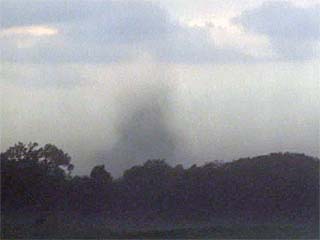
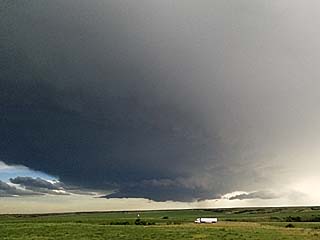
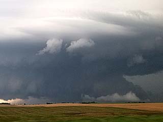
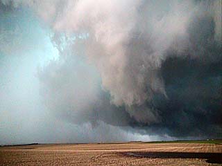
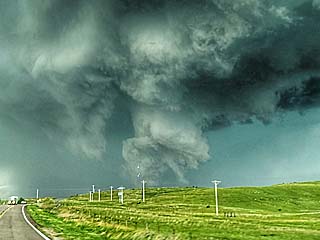
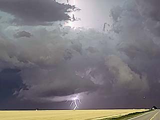
View of HP supercell embedded in a cluster of severe thunderstorms, looking north, on April 28 during the late afternoon over NE Oklahoma. Note the wet RFD and "notch". This storm was tornado-warned. |
|
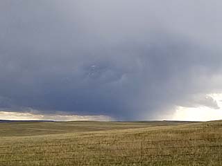
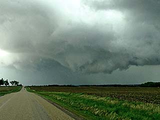
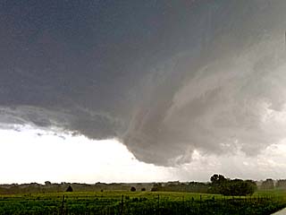
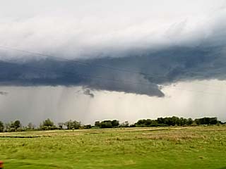
Wall cloud on an HP supercell embedded in a cluster of severe thunderstorms, looking west and northwest in NE Oklahoma during the late afternoon of April 28. The storm here is about to be undercut by surging outflow. |
|
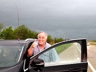
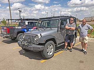
Jeff Piotrowski and his vehicle during storm chasing north of Tulsa, Oklahoma on April 28. |
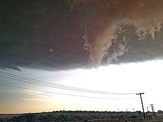
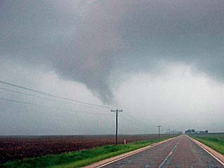
|
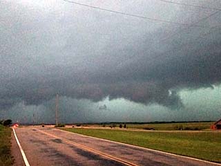
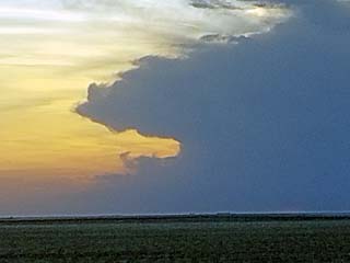
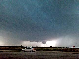
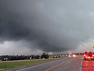
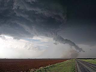
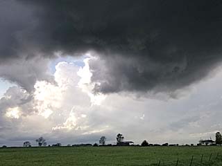
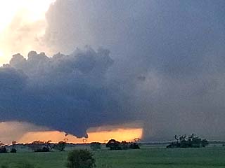
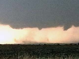
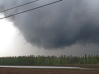
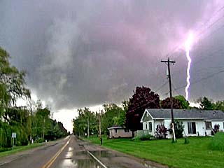
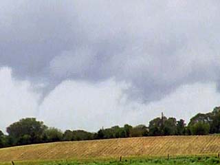
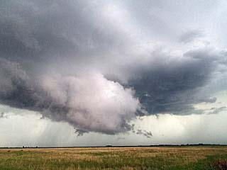
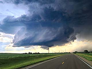
View of the southwestern portion of an HP supercell storm moving over Tulsa, Oklahoma on April 28 during the evening. A funnel and wall cloud can be seen here, and this storm was tornado warned. |
|
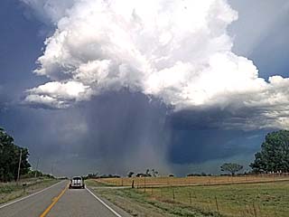
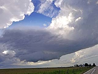
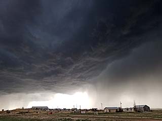
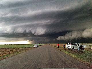
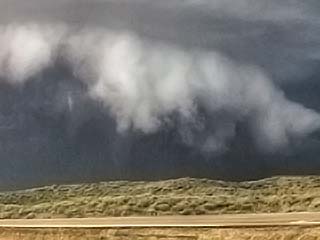
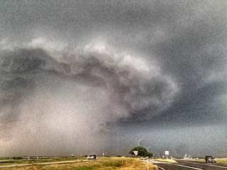
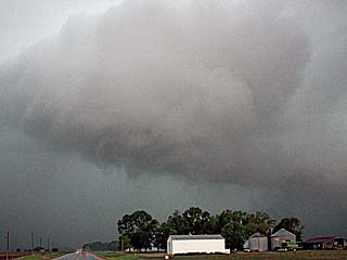
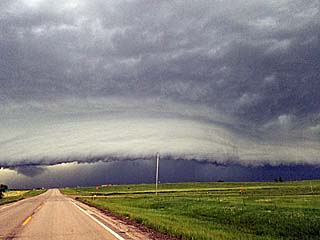
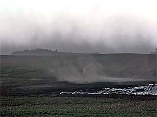
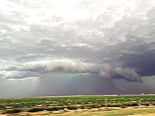
View of powerful gust front and shelf cloud during the early evening of April 28 near Haskell, Oklahoma. |

|
The period from April 29 to May 1 was down time without any significant weather setups. In this picture, I am cutting my own hair since there was simply no place to get it cut! Barber shops remained closed due to the COVID-19 crisis as of April 29, 2020. |

|
Cheapest gas I have seen since the mid 1980s! This was at a gas station near Norman, Oklahoma on April 29, where gas was a mere 89 cents a gallon. |
|
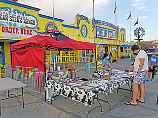
The famous Big Texan steakhouse in Amarillo, Texas. Here with social distancing becoming somewhat less constrained by May 1, this establishment offered limited outdoor seating, delivery, and pickup / on-line ordering amid the COVID-19 crisis of 2020. The main dining area remained closed. |
|
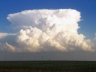
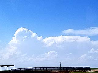
Weak, high-based (and low topped) convection producing mainly virga and small hail near Amarillo, Texas on May 1. |

|
Myself enjoying the 22 oz rib-eye steak in my hotel room late in the day on May 1. |
|
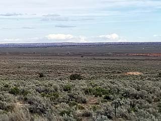
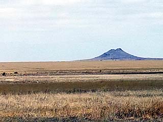
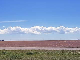
View across the open grassland towards Twin Butte, an extinct volcanic formation in Prowers County in SE Colorado, looking east from Highway 385 headed north on May 2. |
|
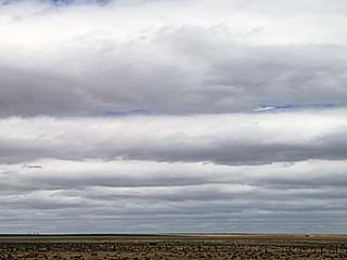
Horizontal convective rolls affecting the low level cloud deck in eastern Colorado during the afternoon of May 2. |
|
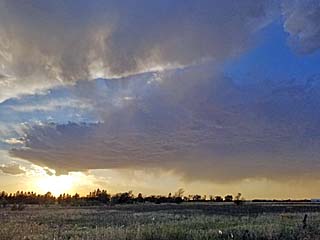
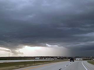
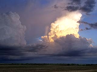
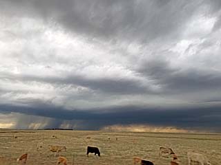
Cluster of strong and severe thunderstorms to the southeast of Denver International Airport late in the day on May 2. |
|
Radar (base reflectivity) image of a small supercell thunderstorm southeast of the Denver area during the evening of May 2. |
|
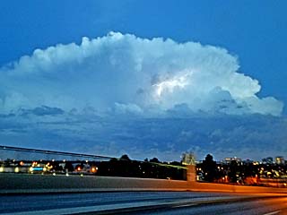
View of a small supercell thunderstorm with lightning moving east and southeast of the Denver area during the evening of May 2 after dusk. |
|
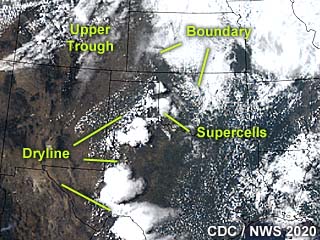
Annotated visible satellite (around 23z) showing storms developing from NE Colorado into SW Nebraska during the late afternoon of May 3. |
|
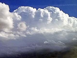
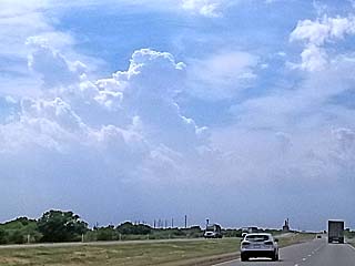
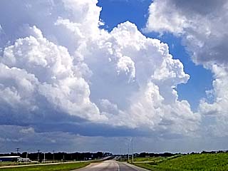
Organizing, agitated cumulus over the Palmer Divide in NE Colorado, looking south and southwest from northwest of Limon during the afternoon of May 3. |
|
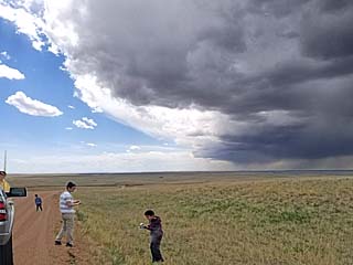
Developing high-based up-slope thunderstorms on the Palmer Divide in NE Colorado, looking west from near the Cedar Point exit off I-70 during the afternoon of May 3. The people in the foreground are not storm chasers, just a family stopped there to take in the view. |
|
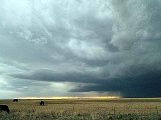
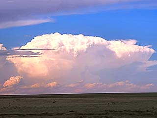
Developing severe storm near Yuma, Colorado during the afternoon of May 3. |
|
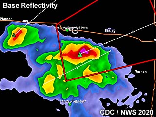
Radar (base reflectivity) image of a severe-warned storm southeast of Yuma, Colorado during the afternoon of May 3. |
|
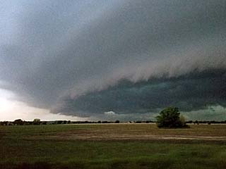
Shelf cloud and hail core of a severe thunderstorm, looking east along Highway 34 between Yuma and Wray, Colorado during the evening of May 3. |
|
Supercell and back-sheared anvil looming in the western sky (from NW Kansas) at around dusk on May 3. |
|
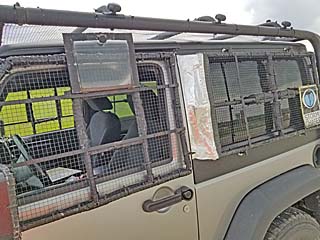
Vehicle with hail-guards installed for the chase in NE Oklahoma on May 4. |
|
Approaching a developing HP supercell from the north in NE Oklahoma (near Foyil) during the afternoon of May 4. |
|
Annotated visible satellite of storms over Oklahoma at around 23z on May 4. |
|
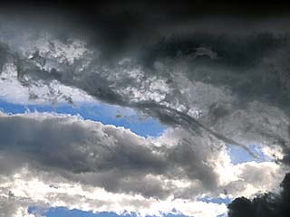
Small funnel / rotating wall cloud on developing H supercell storm near Foyil, Oklahoma on May 4. The view is to the west. |
|
Radar (base reflectivity) image of a supercell storm (with velocity inset) west of Salina, Oklahoma during the late afternoon of May 4. |
|
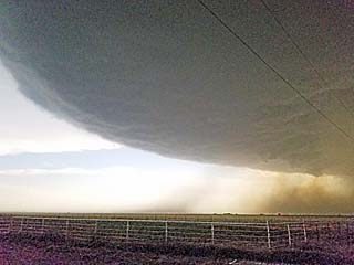
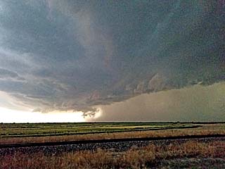
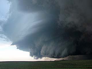
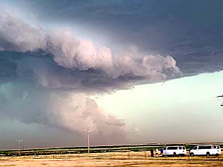
View of HP supercell notch, looking to the southwest, and into the low level mesocyclone west of Salina, Oklahoma late in the afternoon on May 4. |

|
Rolling tail cloud feeding in rapidly from right to left into the wall cloud of an HP supercell storm southwest of Salina, Oklahoma late on May 4. The view is to the west and southwest. Note the splashes of hail in Hudson Lake in the foreground. |
|
Weakening HP supercell storm, with area of rotation, looking northeast from the southeast of Salina, Oklahoma during the evening of May 4. The view is to the NNW |
|
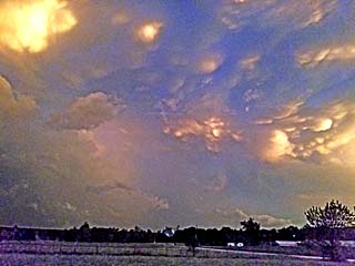
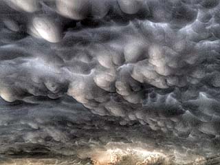
Mammatus clouds looking west and southwest near dusk in NE Oklahoma / NW Arkansas during the evening of May 4. |
|
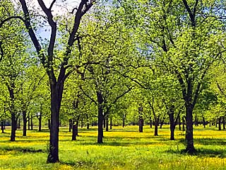
Beautiful carpet of yellow wildflowers blanket a pecan grove while traveling to Wichita, Kansas (this was near Sherwin) on May 5, which was a travel day. |
|
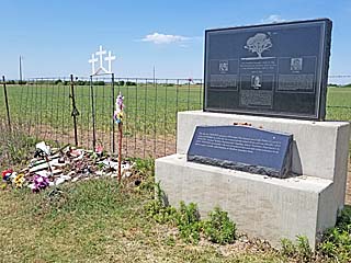
Stopping at the memorial for Tim and Paul Samaras, and Carl Young, killed in the 2013 El Reno tornado. This was on May 6 near Radio and Reuter road in SW El Reno. |
|
Convective initiation of storms near the intersection of a frontal boundary and dryline west of Childress, Texas during the afternoon of May 7. The view is to the west along Highway 287. |
|
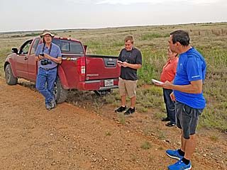
Tim Marshall and a few other storm chasers watching a developing supercell storm west of Childress, Texas during the afternoon of May 7. |
|
Development of supercell thunderstorm near Childress, Texas during the late afternoon of May 7. The view is to the northwest. |
|
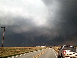
Wall cloud and smoke (from a fire started by lightning) being pulled into the developing supercell storm east of Childress, Texas on May 7. The view is to the north. |
|
Impressive supercell leading edge to the west of Chillicoth, Texas during the late afternoon of May 7. The view is to the SSW. Isolated hail to near baseball sized was falling in this area. |
|
Annotated visible satellite image, at about 22z, of the synoptic setup and storms developing in NW Texas during the afternoon of May 7. |
|
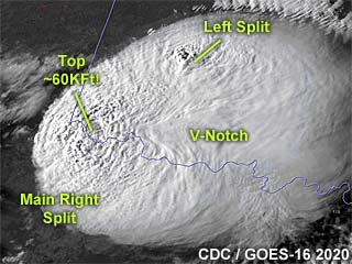
High-resolution GOES-16 visible satellite image, at about 23z, of the powerful supercell storm in NW Texas during the afternoon of May 7. Some storm tops have reached 60,000 feet. Note the left split of the storm pushing to the NE into Oklahoma, as well as the storm V-Notch of the right (main) split moving to the ESE. |
|
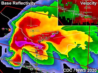
Radar (base reflectivity) image of the supercell storm as it was nearing Chillicoth, Texas during the late afternoon of May 7. The inset in the upper right shows the Doppler velocity of the storm. |
|
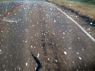
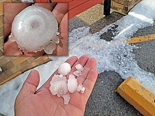
Hail as large as baseballs in the road while penetrating the supercell core near Seymour, Texas late on May 7. |

|
Hail stones on the top hail guards, viewed out the "skylight" windows of my Jeep Wrangler while penetrating the supercell core near Seymour, Texas. |
|
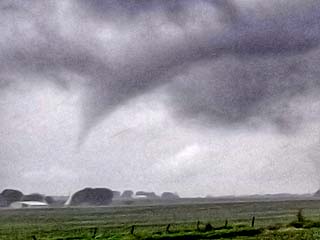
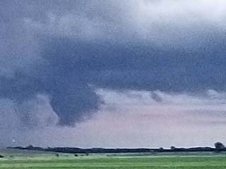
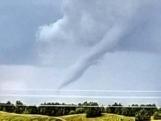
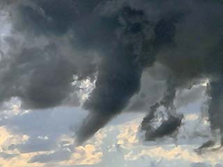
Weakening funnel cloud / tornado just on the edge of the supercell core near Seymour, Texas. This was after a very brief view of it, which is just to the right in the center of this picture. |
|
View of funnel cloud after punching out of the supercell core near Seymour, Texas. |
|
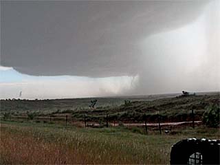
View of inflow side of the powerful supercell storm near Seymour, Texas around dusk on May 7. The view is to the northeast. |
|
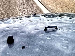
Hail damage to the hood of my Jeep Wrangler, from the May 7 storm, while traveling during off-time on May 8. |
|
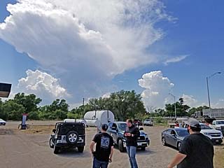
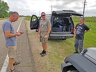
Storm chasers, including Marcus Diaz, on the north side of Canadian, Texas, watching the storms initiate along the dryline to the west during the afternoon of May 13. |
|
Small low precipitation (LP) supercell developing along a bulge in the dryline north of Canadian, Texas during the afternoon of May 13. |
|
Storm chasers along the side of the road north of Canadian, Texas during the afternoon of May 13. |
|
Annotated visible satellite image as of 23z on May 13, showing the synoptic setup as well as the storm evolution at the time in and around the target area in the Texas Panhandle. |
|
View of a small high-based supercell crossing from Texas into Oklahoma during the afternoon of May 13. Note the striations of the weakening storm, as well as the low level mesocyclone to the left. |
|
View of a developing LP supercell storm near Sayre, Oklahoma during the afternoon of May 13. |
|
Base reflectivity radar image of a splitting LP supercell storm east of Sayre, Oklahoma after 23z. |
|
Hail shaft associated with the right split of an LP supercell storm east of Sayre, Oklahoma during the afternoon of May 13. |
|
Down-scaling (shrinking) of the right split of an LP supercell storm east of Sayre, Oklahoma during the evening of May 13. In this case the updraft tower "shrivels" leaving a persistent anvil overhead. |
|
View of anvil of a developing supercell storm near Emporia, Kansas late in the day on May 14. The view is to the south. |
|
Annotated visible satellite image (around 23z) of the chase target area over NE to eastern Kansas on May 14, with important synoptic features around the area pointed out. |
|
View of updraft region and developing RFD (rear flank downdraft) on a classic to LP supercell north of Emporia, Kansas late in the day on May 14. The view is to the west. |
|
View of RFD clear slot on a classic to LP supercell north of Emporia, Kansas late in the day on May 14. The view is to the northwest. |
|
Base reflectivity image of the supercell storm north of Emporia, Kansas on May 14. The inset to the lower left shows the weak Doppler velocity associated with the storm. |
|
Wall cloud with RFD on a down-scaling classic to LP supercell north of Emporia, Kansas late in the day on May 14. The view is to the NNW. |
|
View towards another area of supercell storms to the southwest of Salina, Kansas around dusk on May 14. A large wall cloud can be seen under the main updraft of the storm to the lower left. The view is to the WNW. |
|
View looking east at the backside of severe thunderstorms in east-central Kansas after dusk on May 14. |
|
Annotated visible satellite image of the synoptic setup, as well as storm evolution during the afternoon of May 15. The actual target area was in the up-slope area of NE Colorado, near the Palmer Divide. |
|
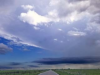
View of storms developing near the Palmer Divide during the afternoon of May 15. The view is to the northwest from I-70, near Limon, Colorado. |
|
Developing supercell storm near Simla / Matheson, Colorado during the afternoon of May 15. The view is to the west and southwest. |
|
Rain-free base and UDI (updraft-downdraft interface) of a supercell storm near Calhan, Colorado during the late afternoon of May 15. The view is to the northwest. |
|
Low-level mesocyclone (center and right) associated with the classic supercell storm near Calhan, Colorado during the afternoon of May 15. The view is to the NNW. |
|
Area of rotation and wall cloud, funnel, and RFD clear-slot near Calhan, Colorado during the evening of May 15. |
|
The supercell storm near Calhan, Colorado begins moving east and evolving into a line segment during the evening of May 15. The view is to the northwest. |
|
Inflow banding into the weakening high-based supercell / line segment during the evening of May 15. The view is to the west. |
|
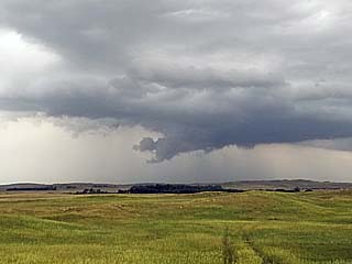
Some convection getting organized close to SW Iowa during the afternoon of May 16. This was a marginal day and chasing was not planned, although a supercell eventually formed in this area and eastward. |
|
Visible satellite image, annotated showing any important features, for the highly marginal setup on May 16. A small supercell has developed by 23z near the convergence area in SW Iowa / SE Nebraska. |
|
Although not chasing on this day, a small and brief tornado-warned supercell storm developed south of Omaha late in the day on May 16. There were no tornadoes with this storm. |
|
Annotated visible satellite image (around 21z) of the synoptic setup on May 17, as well as storm evolution during that afternoon. The target area was in north-central Illinois. |
|
A linear / multicell storm mode was the way storms evolved in north-central Illinois during the afternoon of May 17. |
|
Base reflectivity of storms over north-central Illinois during the late afternoon of May 17. The lower-right inset shows an area of rotation as shown by the Doppler velocity to the yellow line correlates the area of rotation (in the velocity inset) to that in the base reflectivity image. |
|
Area of rotation within a line segment near Forrest, Illinois during the late afternoon of May 17. |
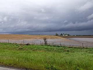
|
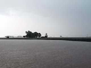
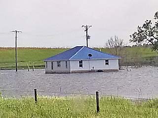
Flooded field and farmstead in north-central Illinois during the evening of May 17. |
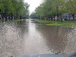
|
Flooded street in a small town in north-central Illinois during the evening of May 17. |

|
Rainbow reflecting over a flooded field in north-central Illinois around sunset on May 17. |
|
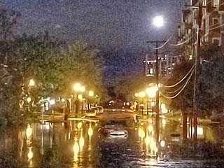
Severe flooding in Wheaton, Illinois during the week of May 17. A car floats in the street during a flash flood in this picture around midnight, and persisted into May 18. |
|
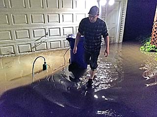
Flooded residence in Wheaton, Illinois early on May 18. A man here is dealing with a flooded yard, garage, and basement. |
|
Storm chaser John Moon and myself meeting up in Liberal, Kansas and getting ready to chase to the north and northwest of town on May 21. |
|
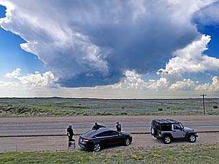
Convective initiation to the west of Ulysses, Kansas during the afternoon of May 21. |
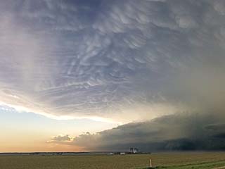
|
A powerful MCS (cluster of severe thunderstorms) pushes eastward towards Syracuse, Kansas during the late afternoon of May 21. Note the green color, as this complex of storms had hail larger than baseballs. The view is to the southwest. |
|
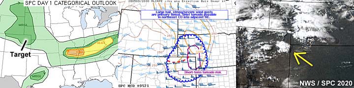
Annotated visible satellite image of the storms and synoptic setup at around 23z on May 21. The target area is in southwest Kansas. |
|
Another supercell storm explosively develops to the southeast and becomes the main target storm. The view here is to the southeast from near Syracuse, Kansas during the late afternoon of May 21. |
|
Approaching a developing classic to HP supercell to the south of Lakin, Kansas during the late afternoon of May 21. The view is to the west. |
|
Extremely severe and tornadic HP supercell south of Lakin, Kansas during the late afternoon of May 21. A possible tornado is barely visible to the lower right of the storm under the base. |
|
Base reflectivity radar image of the later stages of the Lakin tornadic supercell as it began merging into an MCS approaching from the west. The inset to the upper-right shows the Doppler velocity of the storm. |
|
View into the notch of the HP supercell near Lakin, Kansas, showing a possible tornado, just left of the center of the picture. The view is to the southwest during the late afternoon of May 21. |
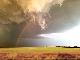
|
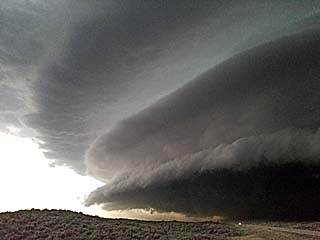
Another view of the leading edge of the wet RFD region, and intense rotation, associated with the Lakin, Kansas storm during the evening of May 21. The view is to the south, showing the impressive "stacked plates" or "mothership" presentation of the supercell. |
|
View of another supercell storm from a truck stop near Sublette, Kansas towards Satanta during the evening of May 21. The view is to the west, showing the impressive structure and "barber pole" / "stacked plates" structure of this supercell. |
|
Convective initiation starting over the Red River southwest of Frederick, Oklahoma during the afternoon of May 22. The view is to the southwest. |
|
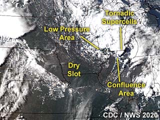
Annotated visible satellite image at roughly 23z during the late afternoon of May 22. This is a very complicated synoptic setup, with a powerful upper-level-low over north-central Kansas / southern Nebraska offering a "cold core" setup with a surface low beneath it. Some supercells with weak, brief tornadoes, formed in this area. The more thermodynamic target area was south along the Red River in north-central Texas / southern Oklahoma, owing to dryline / boundary interactions ahead of the dry slot of the mid level low to the north. |
|
Supercell storm intensifying and beginning to split, with the right-mover becoming the main storm, during the afternoon of May 22. The view is to the north near Davidson, Oklahoma. |
|
Radar (base reflectivity) image of the intensifying Supercell storm along the Red River near Grandfield, Oklahoma and turning southeastward during the afternoon of May 22. Note the northern split of the storm developing, with the right split to become the main storm. The inset to the upper-right shows the Doppler velocity of the storm. |
|
A weak tornado develops on the intensifying supercell storm as it is between Grandfield, Oklahoma and Wichita Falls, Texas. The view is to the WSW on May 22 during the late afternoon. |
|
Closer view of a weak tornado, with ground circulation below a funnel, looking west from near Devol, Oklahoma during the late afternoon on May 22. |
|
View of the supercell storm as it was over Burkburnett, Texas during the late afternoon on May 22. The view is looking to the north and northwest just as it was producing extremely large hail, approaching 6" in diameter! |
|
Powerful RFD (rear flank downdraft) with the supercell storm as is was passing near Shepard AFB in Clay County on May 22. Powerlines are down and blocking the road, with a possible funnel behind the RFD clear slot visible just left of the center of this picture above the ground. The view is to the NNW. |
|
Landspout type tornado on the leading edge of the powerful storm mesocyclone / RFD during the late afternoon of May 22 east of Shepard AFB in Clay County. |
|
View of possible weak tornado over rural areas of Clay County, Texas during the evening of May 22. The view is to the north. |
|
The core of the weakening supercell passes over the small town of Petrolia, Texas after dark on May 22. Hail as large as baseballs, with 70 MPH winds, is pummeling the area. |
|
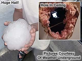
This is a picture of a hailstone from a resident of Burkburnett, Texas after the May 22 storm. The hail punched clear through the roof of their home. The hailstone was probably around 6" in diameter before it melted in this picture. This image is from the Weather Underground site. |
|
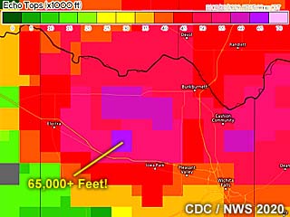
This is a radar image showing the echo tops as the storm was dropping record-breaking hail near Burkburnett, Texas on May 22. The top of this supercell is in the near-space environment of the lower stratosphere, exceeding 65,000 feet (almost 20 km) - Which is double the cruising altitude of a commerical jet airliner! Imagine the view of the overshooting top of this storm, with a solid white cloud against a dark, nearly black / midnight-blue sky, and the curve of the earth visible? |
|
Annotated visible satellite image at roughly 21z during the afternoon of May 23. The area of interest is from eastern Iowa and into NW Illinois, where surface convergence is maximized, and winds backed, ahead of a dry punch east of a weakening stacked surface / upper level low. |
|
View of a low-topped supercell storm just east of the Illinois / Iowa border during the early afternoon of May 23, while trying to catch up with the storms. |
|
Base reflectivity radar image of a small Supercell storm south of Pecatonica during the afternoon of May 23. The inset to the upper-right shows the Doppler velocity of this supercell storm. |
|
Approaching a supercell storm south of Pecatonica during the afternoon of May 23. The view is to the north and the low-level mesocyclone is intensifying to the upper-right. Note the RFD clear slot as well. |
|
Area of strong rotation with rotating wall cloud and funnel in a supercell storm southwest of Rockford, Illinois and near Pecatonica during the afternoon of May 23. The view is to the northeast. |
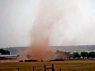
|
Broad and brief tornado in an area of strong rotation forms with a supercell storm west of Rockford, Illinois during the afternoon of May 23. The view is to the northwest. |
|
Brief tornado north of Beloit, Wisconsin during the afternoon of May 23. The view is to the northwest before it became rain-wrapped. |
|
Developing brief tornado north of Beloit, Wisconsin and near Clinton during the afternoon of May 23 as a CG bolt of lightning strikes through the circulation. The view is looking to the southeast at close range. |
|
Annotated visible satellite image for around 22z on May 24. The main target area is highly marginal and in SW Iowa and NW Missouri. |
|
Base reflectivity radar image of storms developing in SW Iowa and NW Missouri on May 24 in the afternoon. The main storm is the "tail-end Charley" supercell storm on the southern portion of this line segment. Weak Doppler velocity is shown in the inset to the upper-right. |
|
Approaching the line segment and tail-end southern storm near Daviess County, Missouri during the afternoon of May 24. The view is to the south. |
|
Storm wall cloud just prior to being under-cut by outflow in Daviess County, Missouri during the afternoon of May 24. The view is to the SSE. |
|
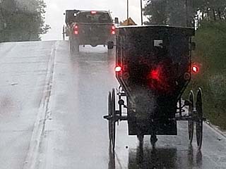
The area in northwest Missouri and southwest Iowa is home to a substantial Amish population. In this picture, a horse-drawn buggy is along the side of the road during a heavy rain as storms weaken. |
|
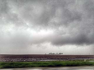
Convective initiation of strong thunderstorms in central Iowa during the afternoon of May 25. These storms were high-based and did not last very long. |
|
Rainbow below high-based weakening storms west of Cedar Rapids, Iowa late in the day on May 25. The view is to the east. |
|
Base reflectivity radar image of storms in eastern Iowa during the early evening of May 25. This will go on to produce a brief funnel (shown below). Weak Doppler velocity is shown in the inset to the upper-left. |
|
Brief funnel cloud on a thunderstorm to the east of Cedar Rapids, Iowa late in the day on May 25. The view is to the NNW. |
|
Annotated visible satellite image for around 21z on May 26. The area of interest, mainly for tornadoes, is northeast of a weakening surface low due to confluence and backed low-level flow to the northwest of Des Moines, and northward to the MN border. |
|
Brief view of a tornado in Polk County, Iowa (NW of Des Moines) during the afternoon of May 26. The view is to the north west. |
|
Wall cloud and RFD area of a small supercell storm near Ortega, Iowa during the afternoon of May 26. A developing tornado is just left of the center of this picture. The view is to the northwest. |
|
Base reflectivity radar image (with Doppler velocity) inset during the afternoon of May 26. This was a small supercell storm in a cluster of strong and severe storms, near Ortega, Iowa. |
|
Cone tornado roping out near Ortega, Iowa during the afternoon of May 26. No damage was done. The view is to the west. |
|
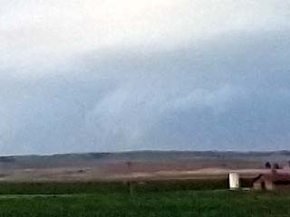
Area of low-level rotation with a thunderstorm near Garner, Iowa on May 25. The view is to the west and northwest. |
|
Brief funnel cloud on a thunderstorm near Garner, Iowa on May 25. The view is to the west and southwest. |
|
Wall cloud on a severe thunderstorm near Clear Lake, Iowa on May 25. The view is to the northwest before the storm is being under-cut by outflow and crossing I-35. |
|
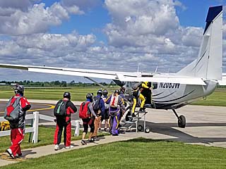
The time from May 27 through June 1 was down time and was spent in the western Chicago suburbs. In this picture, I am enjoying the first day open after the coronavirus pandemic at the skydiving place in Rochelle, Illinois on May 30. |
|
Annotated visible satellite image for around 23z on June 2. The area of interest is in southwestern Minnesota, owing to a weak low pressure area and frontal system. |

|
Convective initiation to the west of Mankato, Minnesota during the afternoon of June 2. The "turkey tower" (tall towering cumulus cloud) here signifies the breaking of a cap, after which explosive thunderstorm development may occur. |
|
A developing supercell storm rapidly forms to the west of Mankato, Minnesota during the late afternoon of June 2. |
|
Hail from quarter to golfball sized bouncing in the grass south of Mankato, Minnesota with a severe supercell storm during the late afternoon of June 2. |
|
Strong winds and tree debris between Mankato and Mapleton, Minnesota during the late afternoon of June 2. |
|
A brief tornado, most likely a large gustnado, between Mankato and Mapleton, Minnesota during the late afternoon of June 2. |
|
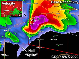
Radar (base reflectivity) image of a supercell storm in SW Minnesota during the late afternoon of June 2. The Doppler velocity of this storm is shown in the upper-left inset. Another interesting feature is a "hail spike" protruding southwest from the storm core on the reflectivity image, caused by the radar beam bouncing off large hail and the ground. |
|
View of powerful RFD with funnel / possible tornado to the far left as a supercell storm pushes southeastward towards Mapleton, Minnesota during the afternoon of June 2. The view is to the east and northeast. |
|
The supercell storm evolves from HP to a powerful line segment northwest of Albert Lea, Minnesota during the early evening of June 2. The view is to the northwest. |
|
Visible satellite image for around 23z, with annotations showing the target region and synoptic setup for June 3. |
|
Convective initiation looking northwest from Highway 83 north of North Platte and south of Valentine, Nebraska during the afternoon of June 3. A developing supercell storm is visible over the horizon. |
|
Radar (base reflectivity) image of a supercell storm with very large hail in Cherry County, Nebraska during the afternoon of June 3. The "white" is extremely intense radar returns, in excess of 70 dBz. The insets to the upper-right shows any Doppler velocity in the storm, with a vertically integrated liquid (VIL) in excess of 80 below that. |
|
View of the supercell storm becoming outflow dominant west of Highway 83 in Cherry County, Nebraska during the mid to late afternoon of June 3. |
|
View of the approaching core of the Cherry County, Nebraska supercell during the afternoon of June 3. A dust plume / gustnado can be seen in the center of the picture. |
|
Marble sized hail covering the ground as the area is glanced by the weakening core of the Cherry County, Nebraska supercell during the afternoon of June 3. |
|
Visible satellite image for around 22z, with annotations showing the target region in central to western South Dakota and synoptic setup for June 4. |
|
Start of a long-range intercept of a supercell storm moving towards the southeast and eventually into Faith, South Dakota. The view is to the north near the Rapid City Doppler radar site on June 4. |
|
View of an outflow-dominant supercell storm moving near Faith, South Dakota. The view is to the northeast during the afternoon of June 4. |
|
Small funnel / rotating wall cloud south of Faith, South Dakota before being undercut by outflow. Note the hail core to the left. The view is to the east during the afternoon of June 4. |
|
Base reflectivity radar image of a supercell storm approaching Faith, South Dakota during the afternoon of June 4. Note the "white" returns, in excess of 70 dBz. The inset to the upper-right shows the Doppler velocity in the storm. |
|
Another powerful supercell storm passes to the south of Wall, South Dakota over the Badlands, after pummeling Rapid City with large hail. The view is to the south from I-90 during the evening of June 4. |
|
Partially melted hail picked up from the ground on the eastern side of Rapid City, SD during the evening of June 4. The inset shows a picture of an actual stone with the internal "ring" structure. |
|
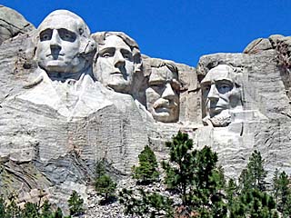
June 5 was an off day spent in Rapid City South Dakota, and included a trip to Mount Rushmore. |
|
Despite being an off day, a "surprise" supercell forms in east-central Wyoming and crosses into extreme NW Nebraska near the SD border late in the day on June 5. This is the visible satellite for 0z on (UTC on June 6), or during the late afternoon of June 5. |
|
Passing through Sturgis, South Dakota and seeing the "Top Throttle" Saloon northeast of town while heading towards the target area during the early afternoon of June 6. |
|
Annotated visible satellite showing important areas of interest after 23z towards the late afternoon of June 6. |
|
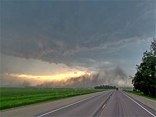
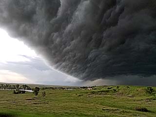
View looking west near Mud Butte, South Dakota as a powerful derecho / MCS approaching rapidly from the west during the evening of June 6. |
|
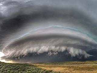
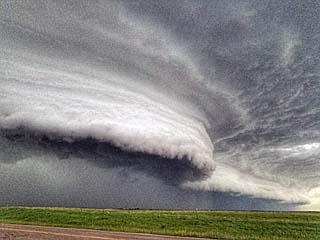
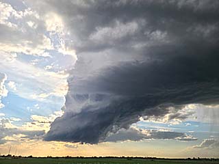
Incredible sculpted shelf cloud associated with a powerful LEWP (line echo wave pattern) at the leading edge a derecho / MCS in Butte County, South Dakota during the evening of June 6. |
|
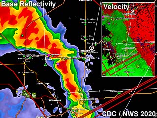
Base reflectivity radar image of the surging MCS / derecho (extreme straight-line winds) during the late afternoon of June 6. The Doppler velocity is shown in the inset to the upper right. |
|
Backside of the shelf cloud (with "whale's mouth feature) on the leading edge of the derecho / MCS passing over Butte County, South Dakota during the evening of June 6. The view is to the SSE. |
|
Extreme winds (gusts with this derecho / MCS exceeded 100 MPH in some areas) northwest of Faith, South Dakota during the late evening of June 6. The view is to the north. |
|
Annotated visible satellite (around 20z) showing important areas of interest during the afternoon of June 7. The main target area was in extreme eastern North Dakota and NW Minnesota, with a warm front oriented NW to SE ahead of a weak surface low and trough. Another potential area for storms is in north-central to NE South Dakota. |
|
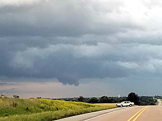
View looking northeast at the warm front (band of low clouds along the horizon) from eastern North Dakota towards the Minnesota border during the afternoon of June 7. This boundary will be the focus for storms later in the afternoon. |
|
Convective initiation of storms east of the north Red River in NW Minnesota and east of the North Dakota border during the afternoon of June 7. The high amount of shear in the atmosphere causes the towering cumulus clouds to be highly tilted with the strong winds / jet stream aloft. The view is to the north. |
|
Base reflectivity radar image during the afternoon of June 7 for NW Minnesota / east of the N Red River in extreme NE North Dakota. The Doppler velocity is shown in the inset to the upper left. |
|
Developing wall cloud with a supercell storm near Kennedy, Minnesota during the afternoon of June 7. The view is to the northwest. |
|
Rotating wall cloud near Kennedy, Minnesota during the afternoon of June 7. The view is to the west. |
|
Powerful winds kicking up dust and gustnadoes after dusk while heading south along I-29 towards Fargo, North Dakota as an MCS pushes through on June 7. The view is to the south. |
|
Annotated visible satellite (after 23z to 0z the next day) showing convective trends and important areas of interest during the evening of June 8. In this complex forecast, the main target area was in central Nebraska ahead of a weak surface low and within a convergence area. Another potential area for storms is in extreme NW Minnesota in a similar area as the prior day, but with storms moving quickly into Canada. |
|
Greg Ansel (center) and his group along Highway 188 in central Nebraska (near Bassett) during the afternoon of June 8. |
|
Passing some flooded homes in the Nebraska Sandhills off Highway 183 on June 8. |

|
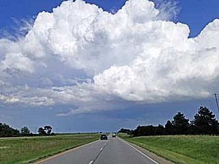
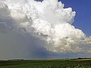
Storms begin initiating near and west of Taylor, Nebraska during the late afternoon of June 8. Here a towering cumulus cloud explosively develops as the capping inversion is breached. |
|
Wall cloud on a weakly rotating storm near Brewster, Nebraska during the late afternoon of June 8. The view is to the north. The main "tail-end" storm is farther south and southwest towards Arnold. |
|
Approaching a tornadic supercell at the tail-end (southern portion) of a storm cluster during the early evening of June 8. The view is to the southwest. A possible tornado is visible just above the horizon and right of the grain bin in this picture. |
|
Close-up (zoomed in) view of possible tornado when approaching the Arnold, Nebraska tornadic supercell during the early evening of June 8. The view is to the southwest. |
|
Another view of a possible tornado (just left of the center of the picture) near Arnold, Nebraska looking to the southwest into a tornadic supercell during the early evening of June 8. |
|
Base reflectivity radar image during the evening of June 8 in central Nebraska. The Doppler velocity is shown in the inset to the upper right. This image shows the powerful tornadic supercell near Arnold, Nebraska. |
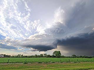
|
Powerful supercell and tornado-cyclone near Arnold, Nebraska during the afternoon of June 8. This storm had an incredible visual presentation. The stream-wise vorticity current (or "rotor") can also be seen to the far right. The view is to the south and SSW. |
|
Another view looking south from inside the inflow "notch" of the supercell and tornado-cyclone near Arnold, Nebraska during the afternoon of June 8. |
|
View inside the "bear's cage" of the storm, with rapidly rotating clouds (center_ and giant hail (to the far right) approaching. The wet RFD (to the left) has almost completely made it around the tornado-cyclone core and will soon obscure this view. The view is to the south during the evening of June 8 near Arnold, Nebraska. |
|
Gustnado / weak tornado passing over the farmland just north of the RFD area and under the main updraft near Arnold, Nebraska late on June 8, just as the storm was becoming outflow dominant and weakening. The view is to the southeast. |
|
Annotated visible satellite (around 20z) showing important areas of interest during the afternoon of June 9. The main target area was in north-central to NE Kansas / SE Nebraska in a confluence area east of a surface low. |
|
A cold front is noted pushing east and southeast of Grand Island, Nebraska during the late morning of June 9. The view here is to the east along I-80. |
|
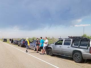
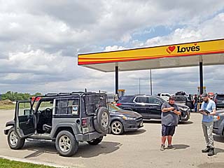
Many storm chasers gather at the Love's truck stop just north of Lebanon, Kansas during the early afternoon of June 9. |

|
Myself putting on the Jeep front hail guards at a Love's truck stop just north of Lebanon, Kansas during the early afternoon of June 9. |
|
Storms initiating during the afternoon of June 9 in north-central to NE Kansas during the early afternoon. |
|
A supercell storm intensifying while heading east on Highway eastward and approaching Marysville, Kansas during the afternoon of June 9. |
|
Base reflectivity radar image during the late afternoon of June 9 in north-central to NE Kansas. A line of supercells is shown developing along a confluence line oriented WNW to SE. The Doppler velocity is shown in the inset to the lower left, with a line matching that area to the supercell in the base reflectivity image. |
|
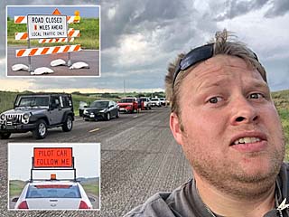
Let the "frustration" begin. The entire caravan of chasers is stopped by a lengthy construction roadblock with a pilot car in use - And we get there JUST AS the lucky few ahead of us got through it (when approaching Marysville, Kansas) during the afternoon of June 9. Construction delays and closed roads plagued this chase day, along with bad road networks later near the Missouri River. Chaser John Moon in this picture is obviously not happy either. |
|
A tornado warned, low-topped supercell pushes to the north of Marysville, Kansas during the afternoon of June 9. |
|
Wall cloud developing on a tornado warned supercell later near Falls City, Nebraska during the evening of June 9 The view is to the northeast. Crossing the Missouri River became yet another frustrating challenge when following these storms. |
|
Wall cloud / rotating scud on a weakening supercell storm after crossing the Missouri River and as it neared Oregon, Missouri after dusk on June 9. The view is to the ENE. |
|
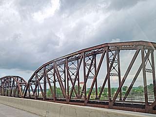
The time from June 10 through the 19th was down time and was spent in the western Chicago suburbs. This is a picture of one of the older bridges, and majestic iron work, still standing and in use across the Missouri River in rural America. |
|
Annotated visible satellite (around 23z) showing important areas of interest and convective evolution during the late afternoon of June 20. The main target area was central Nebraska in a confluence area east of a surface low and along a trough axis. Although not an easy forecast, the Nebraska target area was a good pick given the overall low tornado probabilities. |
|
View looking west towards the central Nebraska target area during the afternoon of June 20. Convective initiation is underway as upper level support / large scale ascent approaches the area, eroding the capping inversion, with agitated towering cumulus on the horizon and some small showers and thunderstorms (anvil forming). |
|
A powerful supercell develops near Purdum, Nebraska and north of Halsey during the afternoon of June 20. The view is to the north. |
|
View looking northeast south of Purdum, Nebraska at the main mesocyclone of the supercell storm on June 20. A rotating wall cloud and developing RFD can be seen here. |
|
A funnel develops as the mesocyclone occludes. This is south of Purdum, Nebraska and north of Halsey during the afternoon of June 20. The RFD occlusion is causing a stretch in the vorticity, like an ice skater bringing in his (or her) arms, and spinning up. The view is to the NNE. |
|
With continued stretching of the rotation, a brief rope tornado becomes visible to the north of Halsey, Nebraska during the afternoon of June 20. The view is to the north. |
|
A brief second tornado develops northeast of Dunning, Nebraska on the south end of a powerful supercell during the late afternoon of June 20. This was the second (eastern) cycle of this storm. |
|
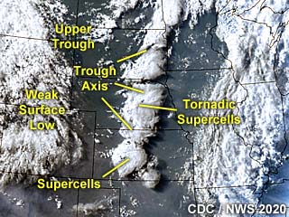
Base reflectivity radar image during the late afternoon of June 20 in central Nebraska. Two powerful and possible tornadic supercells area shown, with a yellow line pointing out the area of the Doppler velocity insets to the left. The northern storm is the supercell that produced tornadoes north of Halsey and near Dunning, and the southern one an LP supercell that produced funnel clouds near Callaway / Broken Bow. |
|
Wall cloud of a beautiful LP supercell between Callaway and Broken Bow, Nebraska during the early evening of of June 20. The view is to the west. |
|
Mid level shear funnel associated with an LP supercell between Callaway and Broken Bow, Nebraska during the early evening of of June 20. The view is to the southwest. |
|
Another funnel, half-way to the ground, associated with the LP supercell west of Broken Bow, Nebraska during the early evening of of June 20. The view is to the WSW. |
|
This is a view of the beautiful LP supercell undergoing downscaling east of Broken Bow, Nebraska during the early evening of June 20. The view is to the NNW. |
|
Final view of the LP supercell undergoing further downscaling east of Broken Bow, Nebraska during the evening of June 20. The view is to the WNW. |
|
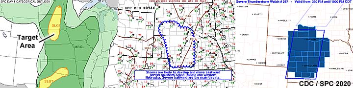
Annotated visible satellite (around 23z) showing important areas of interest and convective evolution during the late afternoon of June 21. The main target area was originally SE Nebraska but later chosen to be SW Kansas. This was mostly a powerful MCS with some supercells on the "tail end" area of the system in Kansas. |
|
Wall cloud near a storm in north-central to central Kansas during the early afternoon of June 21. This was part of a storm system that produced a landspout tornado earlier near Hoxie, Kansas. The view is to the west. |

|
High altitude winds blowing off the storm tops / anvils and giving the sun a "watery appearance" near SW Kansas during the afternoon of June 21. |
|
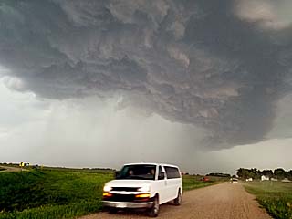
Approaching gust front of a powerful MCS near Dodge City, Kansas during the afternoon of June 21. The view is to the west. |
|
Strong outflow winds kicking up dust near the south end of a powerful MCS south of Dodge City, Kansas during the afternoon of June 21. |
|
Wall cloud of a "tail-end Charley" supercell storm to the northeast of Liberal, Kansas during the early evening of June 21. The view is to the northwest. |
|
Base reflectivity radar image during the evening of June 21 in SW Kansas. A supercell storm is to the northeast of Liberal, Kansas in this image. The Doppler velocity of this storm is in the inset to the upper right. |
|
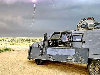
View of lightning strike with the TIV (Tornado Intercept Vehicle) in the foreground, while on a supercell storm to the northeast of Liberal, Kansas during the early evening of June 21. |
|
Lightning striking the ground in Beaver County, Oklahoma south of Liberal, Kansas during the evening of June 21. The view is to the east. |
|
Mammatus clouds over the Oklahoma panhandle near dusk during the evening of June 21. |
|
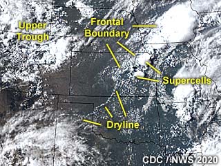
This is an annotated visible satellite of the central USA during the morning of June 22, at around 13z. No convection is occurring here (except for a remnant MCS from the prior day), but some synoptic features, such as boundaries and troughs, can be made out via the annotations. The target area of this final chase day is in the western Texas panhandle. |
|
Storm initiate west of the TX / NM border in New Mexico during the afternoon of June 22. This complex will become a high based MCS of severe storms. The view is to the west. |
|
Looking to the northeast, from the TX / NM border, another supercell storm can be seen about 75 miles to the northeast during the afternoon of June 22. This will become the main storm to target after leaving the high based MCS to the west. |
|
Approaching a supercell storm to the northwest of Sunray, Texas during the evening of June 22. The view is to the NNE. |
|
View of inflow region and wall cloud with the supercell storm to the northwest of Sunray, Texas during the evening of June 22. The view is to the northeast. |
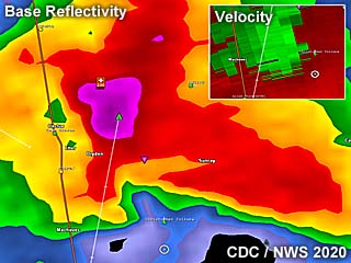
|
Base reflectivity radar image of a powerful supercell pushing southeastward (then southward) near Sunray, Texas during the evening of June 22. The Doppler velocity of this storm is shown in the inset to the upper right. |
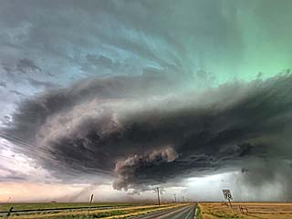
|
A powerful supercell storm pushes southward west of Sunray, Texas and northeast of Dumas during the evening of June 22. The view is to the west. |
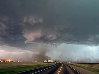
|
Gustnado / possible tornado associated with the supercell storm near Sunray, Texas during the evening of June 22. The view is to the west. |
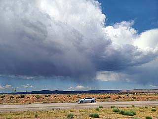
|
June 23 and 24 were travel days and the end of the chase "expedition" for 2020. In this picture, a developing, high-based severe storm can be seen near Santa Rosa, New Mexico during the early afternoon of June 23. |
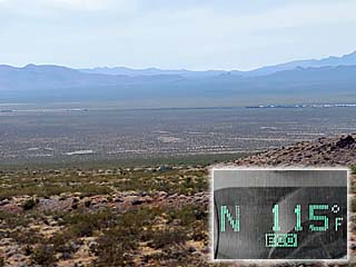
|
View of part of the Mojave Desert in eastern California / western Arizona during the trip back on June 24. It was extremely hot, with a high temperature of 118 degrees observed! In the inset, an outside temperature of 115 deg F is shown. |
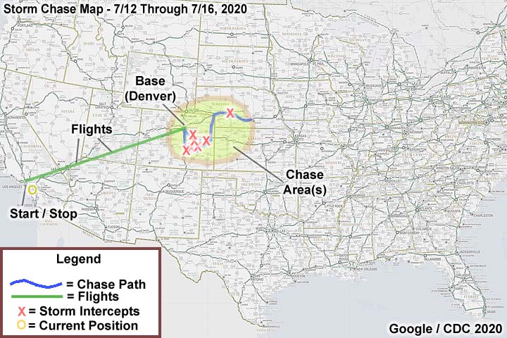
| CHASER NAME | HOME / BASE CITY | CALLSIGN | CHASE DATES | OCCUPATION |
| CHRIS COLLURA | GARDEN GROVE, CA | KG4PJN | 7-12 TO 7-16 | IT CONSULTANT |
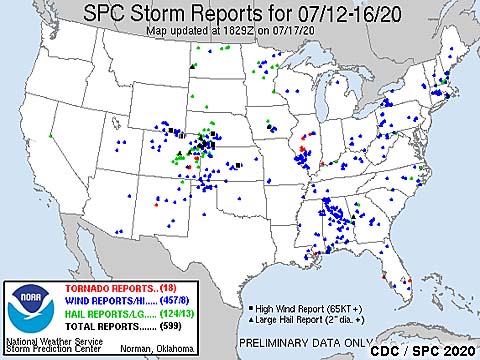
1). July 12, 5:00 PM - Interception and observation of a severe thunderstorm in Lincoln County, Colorado along Highway 40, between Hugo and Boyero. The storm was a small classic supercell that evolved to a bow segment and later weakened. The core of the storm contained at least 1" hail, but it was not penetrated. Other conditions encountered were occasional lightning, some rain, and winds gusting near 40 MPH near the storm. Conditions causing the storm were a surface heating, up-slope wind flow, a low pressure trough, and an approaching upper trough. A 2020 Mitsubishi Eclipse was used to chase the storms. Documentation was digital stills and HD time-lapse video. A severe thunderstorm watch was valid for the area until 9 PM MDT.
2). July 12, 6:15 PM - Interception, observation, and penetration of a very severe, and possibly tornadic thunderstorm in Cheyenne County, Colorado, and near Cheyenne Wells along Highways 40 and 385. The storm was a multicell cluster of storms that evolved to a supercell storm, with cloud tops as high as 65,000 feet. Looking to the SE west of Cheyenne Wells, a possible tornado developed, shrouded by rain and appearing as rotating dust. The storm core also had hail up to 2", with some pieces observed at 1" before turning around. The storm also had winds near 70 MPH, frequent lightning, and very heavy rain. Some tree damage and flash flooding was noted near Cheyenne Wells. Conditions causing the storm were a surface heating, up-slope wind flow, a low pressure trough, and an approaching upper trough. A 2020 Mitsubishi Eclipse was used to chase the storms. Documentation was digital stills and audio. A severe thunderstorm watch was valid for the area until 9 PM MDT.
3). July 13, 8:00 PM - Observation, and indirect penetration of a very severe thunderstorm to the southwest and towards North Platte, Nebraska in Lincoln County, south of I-80 and near SR 23 and Highway 83. The storm was a cluster of severe thunderstorms, with a powerful HP storm, then evolved to a line / bow segment. The storm contained hail to golfball sized and winds gusting over 80 MPH. The core was not directly penetrated. Conditions encountered were 70 MPH wind gusts, frequent lightning, and moderate rain. The storm caused tree damage and power outages in North Platte. Conditions causing the storms were surface heating, a low pressure trough, upper trough, and stationary frontal zone. A 2020 Mitsubishi Eclipse was used to chase the storms. Documentation was digital stills. A severe thunderstorm watch was valid for the area until 12 AM CDT (the following day).
4). July 14, 5:30 PM - Observation and indirect penetration of a severe thunderstorm near Rush, Colorado in Lincoln County and west of Punkin Center along SR 94. The storm was a small, classic supercell storm. A rotating wall cloud was noted on the SW side of the supercell before it weakened. The main core was not directly penetrated, and conditions encountered were moderate rain, frequent lightning, 60 MPH winds, and hail up to 1". Conditions causing the storms were surface heating, a low pressure trough, upper trough, and up-slope wind flow. A 2020 Mitsubishi Eclipse was used to chase the storms. Documentation was digital stills, time-lapse video, and audio. A severe thunderstorm watch was valid for the area until 9 PM MDT.
5). July 14, 7:15 PM - Interception, observation, and penetration of a very severe thunderstorm near Ordway, Colorado in Crowley County along SR 71 and 96. The storm was a powerful HP supercell storm. A rotating wall cloud was noted approaching the storm from the north. The storm also produced some brief rain wrapped vortices as it evolved to an MCS and produced strong winds. Conditions encountered were torrential rain, frequent lightning, at least 70 MPH winds, and hail up to 1". Some tree damage and flooding was noted in Ordway as well. Conditions causing the storms were surface heating, a low pressure trough, upper trough, and up-slope wind flow. A 2020 Mitsubishi Eclipse was used to chase the storms. Documentation was digital stills and audio. A severe thunderstorm watch was valid for the area until 9 PM MDT.
6). July 15, 3:15 PM - Observation and indirect penetration of a severe thunderstorm in El Paso County, Colorado, near Myers Road. The storm was an LP supercell that evolved to classic mode, and weakened via down-scaling later on. Conditions encountered were hail from 3/4" to 1", lightning, heavy rains, and 50 MPH wind gusts. Conditions causing the storms were surface heating, a low pressure trough, upper trough, and up-slope wind flow. A 2020 Mitsubishi Eclipse was used to chase the storms. Documentation was digital stills and audio. A severe thunderstorm watch was valid for the area until 9 PM MDT.
7). July 15, 4:30 PM - Observation and indirect penetration of a severe thunderstorm in El Paso County, Colorado, along I-25 and south of Colorado Springs. The storm was a classic to HP supercell that evolved to a line segment. Conditions encountered were hail to 3/4", lightning, torrential rains, and 60 MPH wind gusts. Conditions causing the storms were surface heating, a low pressure trough, upper trough, and up-slope wind flow. A 2020 Mitsubishi Eclipse was used to chase the storms. Documentation was digital stills and audio. A severe thunderstorm watch was valid for the area until 9 PM MDT.
This concludes the chase log for the central US Plains (including chases in Colorado and Nebraska) chase trip for July 12-16, 2020. The summary includes a total of 7 observations, out of which there were 7 severe thunderstorms. 1 possible tornadoes were observed from these severe storms. The main chase vehicle conducting all these chases was a 2020 Mitsubishi Eclipse. Total miles logged was 1,684 miles. This information was prepared exclusively for the National Weather service and the team of Skywarn storm spotters.
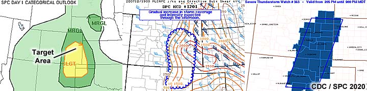
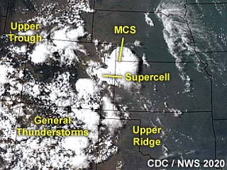
|
This is an annotated visible satellite image for around 23z on July 12. The important features are shown, with an upper trough and up-slope wind flow over east-central Colorado. The supercell storm being targeted was near Cheyenne Wells. |
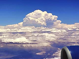
|
While flying out from California to Denver and over the Rocky Mountains, the unmistakable and explosive top of a supercell storm (probably near Colorado Springs) punches into the stratosphere and clearly much higher than our 37,000 foot cruising altitude. The view is to the east during the early afternoon of July 12. |

|
One of the most frustrating things is getting in and running to leave the airport (negotiating buses and trains), pick up the rental car, and rush out to the target area - Only to find THIS. Poor customer service and handling at the Avis rental car center (with Payless and Budget combined into the Avis company) causes dozens of people to be stuck in this line. I have Avis Preferred but they could not find my reservation, so I was forced to wait - Up to two hours - To get my rental car. No kiosks either - Terrible. A similar thing happened in May 2013, causing me to miss the Rozel, Kansas tornado by 20 minutes. |
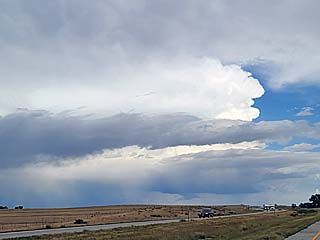
|
Approaching a small supercell storm that is developing near and east of Limon, Colorado while heading east on I-70 towards the target area during the afternoon of July 12. |
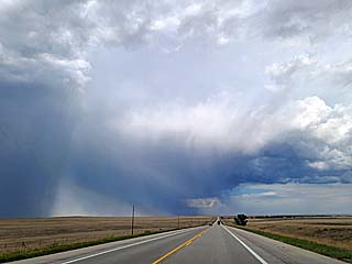
|
Another view of the supercell storm moving southeast of Limon, Colorado during the afternoon of July 12. Note the prominent hail shaft (bright precipitation area to the lower left) of the storm. The view is looking ENE. |
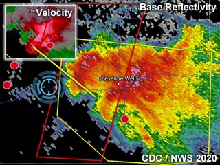
|
This is an annotated base reflectivity radar image during the late afternoon of July 12. The inset to the upper-left shows the velocity of the storm, which produced a brief tornado near Cheyenne Wells, Colorado. Although not shown, this storm had echo tops to 68,000 feet! |
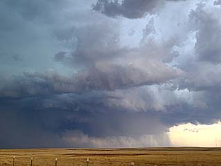
|
Approaching another powerful supercell storm near Cheyenne Wells, Colorado during the late afternoon of July 12. A possible weak tornado is also developing under the main updraft along the lower-center of the picture. The view is looking ESE. |
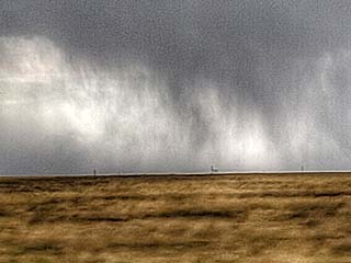
|
Possible weak, dusty tornado becoming rain wrapped to the east of Cheyenne Wells, Colorado during the early evening of July 12. |
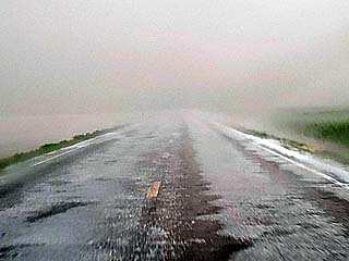
|
Hail covers the ground and "hail fog" develops just south of Cheyenne Wells, Colorado during the early evening of July 12. |
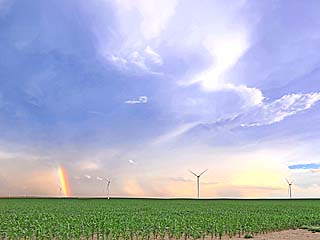
|
Severe storms weakening / moving southeast and with tops spreading out into anvils during the evening of July 12. Note the rainbow on the backside of one of the storms cells. The view is to the southeast from near Burlington, Colorado. |
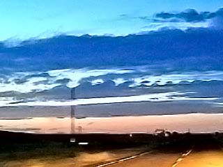
|
Interesting view of Kelvin Helmholtz waves in the mid to high level clouds associated with a portion of the jet stream looking northwest over extreme NE Colorado near Julesburg after dark on July 12. |
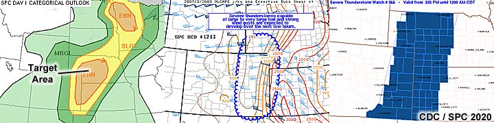
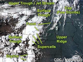
|
This is an annotated visible satellite image for after 23z on July 13. This rather complicated setup shows two target areas, one over west-central to NW Minnesota, and another in western to central Nebraska. The latter showing some supercell storms developing, while the Minnesota area - Which looked "good on paper" - Never developed storms due to veering low level winds and a capping inversion. |
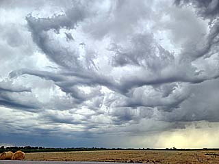
|
This is a view of the sky west of Ogallala, Nebraska during the afternoon of July 13. The approaching short wave (upper trough) gives the sky a "chaotic" appearance like this, with anvil blow-off from developing storms and altocumulus castellanus (and rare asperatus) clouds. The view is to the southwest. |
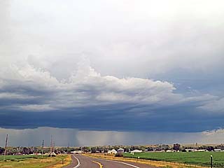
|
Convective initiation takes place over western to SW Nebraska and to the west of Ogallala. Here a severe thunderstorm is developing during the late afternoon of July 13. The view is to the west and northwest. |
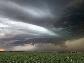
|
This is a view of a developing line segment / supercell storm to the southwest of Ogallala, Nebraska during the late afternoon of July 13. The view is to the west. Note the inflow banding from left to right and the wall cloud to the lower right. The green color to the right denotes large hail. |
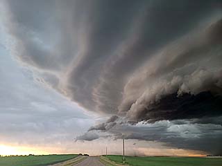
|
Another view of a developing supercell storm to the south of Ogallala, Nebraska during the early evening of July 13. The view is to the SSW showing the leading edge of the storm and impressive structure. |
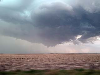
|
A brief funnel forms on the updraft base of the supercell storm to the southeast of Ogallala, Nebraska during the early evening of July 13. The powerful RFD is surging from left to right in this picture, as the storm starts becoming outflow dominant (winds gusting over 75 MPH). The view is to the north. |
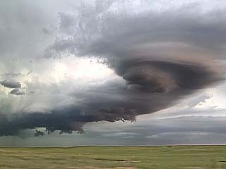
|
The RFD surges out, forming a bow segment ahead of the supercell storm southeast of Ogallala, Nebraska and southwest of North Platte during the evening of July 13. This is a "book-end vortex", showing an anti-cyclonic (clockwise) flow on the south end of the bow segment (just right of the center of this picture), with the cyclonic (counter-clockwise) flow farther north (far left in this picture) with the main supercell. The view is to the NNE. |
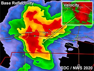
|
This is an annotated base reflectivity radar image during the evening of July 13. This shows the supercell storm nearing North Platte, Nebraska. The inset to the upper-right shows the weak Doppler velocity of the storm. This supercell, as it evolved to a bow segment, would produce winds gusting to nearly 90 MPH in North Platte. |
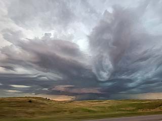
|
View looking northwest towards a developing HP supercell approaching North Platte in Lincoln County, Nebraska during evening of July 13. This storm would produce wind gusts approaching 90 MPH in North Platte. |
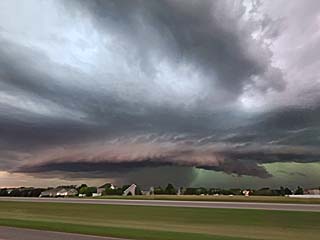
|
Another view looking west towards an HP supercell approaching North Platte, Nebraska during evening of July 13. Note the wall cloud and "wet" RFD punching out to the left of it, forming a shelf cloud. |
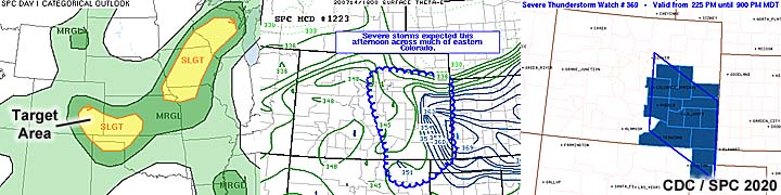
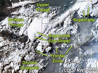
|
This is an annotated visible satellite image for after 23z on July 14. Another complicated forecast scenario is presented, with a line of storms / supercells in central to NE Iowa, and post-frontal up-slope in central to eastern Colorado. |
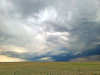
|
View looking west towards thunderstorm initiation from Punkin Center, Colorado during afternoon of July 14. |
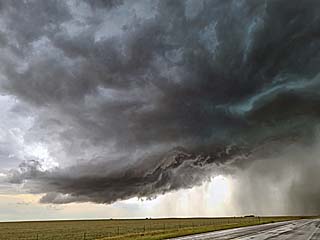
|
View looking west and southwest towards a supercell thunderstorm between Punkin Center and Rush, Colorado during afternoon of July 14. |
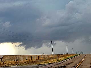
|
Wall cloud and funnel cloud from a supercell thunderstorm between Punkin Center and Rush, Colorado during afternoon of July 14. The view is to the WSW. |
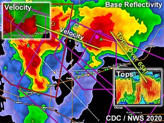
|
This is an annotated base reflectivity radar image during the late afternoon of July 14. Two powerful supercells are over Crowley County, Colorado and are tornado-warned. In the inset to the upper-left, the Doppler velocity is shown, although not particularly strong. The inset to the lower-right is a vertical structure of these supercells, courtesy of Steve Hodanish (Pueblo NWS), with echo tops exceeding 65,000 feet! Also note the prominent BWER (bounded weak echo region) in that image, basically just right of the center of the image, from the eastern supercell. |
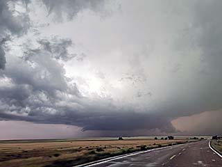
|
Approaching an HP supercell thunderstorm (tornado-warned) north of Ordway, Colorado during late afternoon of July 14. The view is to the south. Note the low and rotating wall cloud in the center of the picture. The view is to the south. |
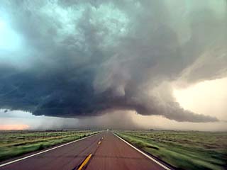
|
View looking south towards a powerful HP supercell north of Ordway, Colorado during late afternoon of July 14. The view is towards the south at the wall cloud / "bear's cage" of the storm, which was one of two tornado-warned supercells at the time. |
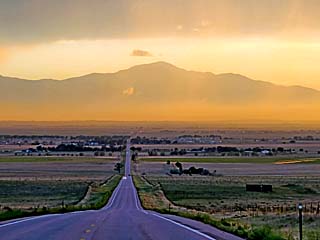
|
View looking west on Highway 74 towards Colorado Springs, Colorado after dusk on July 14. The view of 14,120 foot Pikes Peak is absolutely beautiful looking west along this route. |
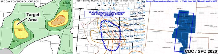
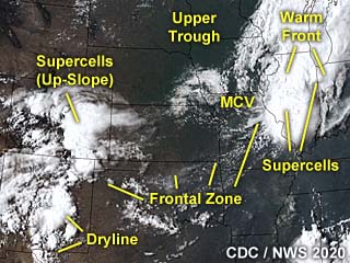
|
This is an annotated visible satellite image for around 22z on July 15. The image points out the synoptic setup, with tornado-warned supercells east of an MCV (mesoscale convective vortex) / surface low in Illinois, and up-slope storms in central Colorado. |
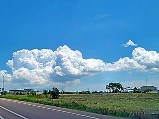
|
This is a view of convective initiation to the east and southeast of Colorado Springs, Colorado during the afternoon of July 15. This cloud will quickly develop into a supercell storm. The view is to the ESE. |
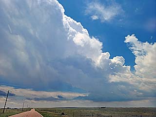
|
View of a developing LP supercell storm to the east and southeast of Colorado Springs, Colorado during the afternoon of July 15. The view is to the south. |
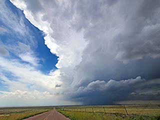
|
View of a supercell storm to the southwest of Rush, Colorado and to the east and southeast of Colorado Springs during the afternoon of July 15. The view is to the west. Note the anvil blow-off and inflow from the right to left. |
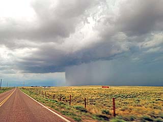
|
The LP supercell to the east and southeast of Colorado Springs, Colorado evolves to classic mode, then a line segment during the late afternoon of July 15. In this picture, an impressive hail core extends from right to left, with a rain "foot" developing to the left of the precipitation near the ground. The view is to the WNW. |
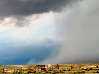
|
Closer view of the rain "foot" developing to the left of the precipitation core of the supercell east and southeast of Colorado Springs, Colorado during the late afternoon of July 15. |
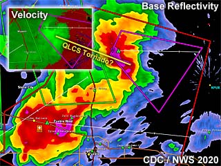
|
This is an annotated base reflectivity radar image during the afternoon of July 15. Some storms are shown in central Colorado east of Colorado Springs and near Wigwam. The inset to the upper-left shows the Doppler velocity, denoting an intense rain-wrapped circulation (possible QLCS / embedded weak tornado) in one of the storms to the east of Colorado Springs. |

|
Strange small hailstone (conical shaped, like a mini "traffic cone") from a supercell east and southeast of Colorado Springs, Colorado during the late afternoon of July 15. |
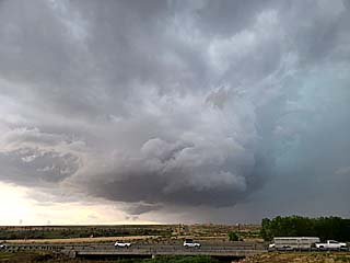
|
View of a supercell storm, and low level mesocyclone, north of Pueblo, Colorado (near Wigwam) and south of Colorado Springs during the afternoon of July 15. |

|
This picture was taken while flying out of Denver International Airport and on the way to Los Angeles during the afternoon on July 16. Heavy turbulence is rocking the plane as we punch through elevated showers and thunderstorms over the Rocky Mountains and break out into clear skies above the fast moving clouds (~400 knots). |
1). Mar 10, 6:45 PM - Observation of a severe and possible tornadic thunderstorm in Kern County, California, west of Highway 395, and northwest of Boron and north of California City. The storm was part of a cluster of low-topped severe storms, with embedded supercells. The storm observed was a classic to HP supercell storm, and a wall cloud and funnel, possible briefly touching down, was observed looking westward from Highway 395 north of Boron. The core of the storm was not penetrated. Other conditions observed were 30 MPH inflow winds and frequent lightning. The storm were caused by a strong upper-level low pressure area, convergence, boundary interactions, and a surface trough. A 2016 Jeep Wranger was used to chase the storms. Documentation was digital stills.
This concludes the chase log for the central United States and Midwest for ANY OTHER chases in 2020 not part of a special section (especially those for single-day "spot" chase trips). The summary includes a total of 1 observation, out of which there was 1 severe thunderstorm. With this thunderstorm, 1 possible tornado was observed. The main chase vehicle conducting these chases was a 2016 Jeep Wrangler. This information was prepared exclusively for the National Weather service and the team of Skywarn storm spotters.
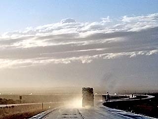
|
Heading westward along Highway 58 out of Barstow, California and into Kern County on March 10, 2020 during the late afternoon. There is a tornado warned supercell storm that is being intercepted. The storm is low topped, barely above 20,000 feet high, developing ahead of a strong upper-level low pressure system to the southwest near the SW California coast. A glimpse of the overshooting top can be seen just above the center of this picture. |
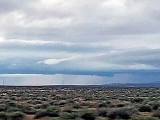
|
The shallow mesocyclone comes into view, looking westward from Highway 395 to the northeast of Boron, California on March 10. Here a wall cloud and shallow low level mesocylone can be seen. |
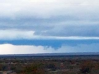
|
Brief funnel develops with rapidly rotating scud shortly after the picture of the wall cloud above was taken. I was not able to confirm ground contact due to the terrain. This storm was one of two supercell storms, in the California desert between Boron and California City (Kern County), which is also to the north of Edwards Air force Base. This was March 10. |
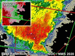
|
Radar image (base-reflectivity) of the March 10 Kern County storm at maximum intensity. The inset shows the velocity of the storm. |
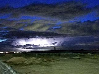
|
Frequent lightning after dusk from the low-topped supercell storm in Kern County, California on March 10. |
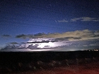
|
A final shot of the weakening supercell storm over Kern County, California on March 10, illuminated by frequent lightning. |
HTML File "mwcl2020.htm" - Developed By Chris Collura
To Return To The HOME Page Of This Site Click The "INDEX.HTM" Link Here!