
| This section is for storm chases done in the central / Midwestern United States during the year of 2019. This includes all storm chasing activities (including any major chase "expeditions") during the year of 2019 in the central USA (aka "Tornado Alley"). For 2019, all chases in the central USA will be logged in this section, with many of the chases being possible "spot" chases / major severe weather "setups" chased. Here you should find many pictures of lightning, tornadoes, hail, strong winds, along with many severe thunderstorm elements. Keep in mind that this chase log is scientific evidence and portrays my on-going storm chasing research. It has been placed on this page for easy reference and meteorological interests. Please do not plagiarize or copy this document to other sites for distribution. Note - This page may take a while to load on some SLOWER connections! |
STORM CHASING - CENTRAL UNITED STATES - 2019 CHASE LOG
| CHASER NAME | HOME / BASE CITY | CALLSIGN | CHASE DATES | OCCUPATION |
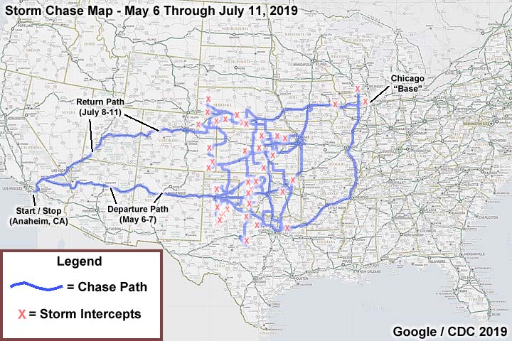
| CHRIS COLLURA | ANAHEIM, CA | KG4PJN | 5-6 TO 7-11 | IT CONSULTANT |
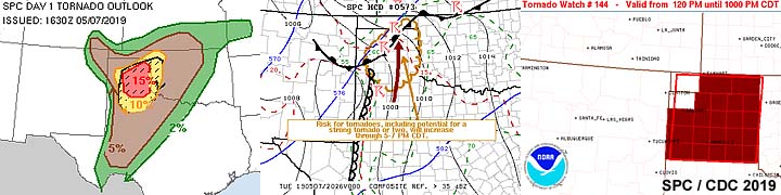
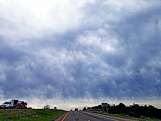
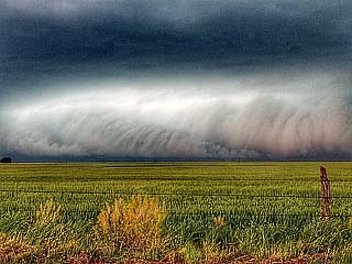
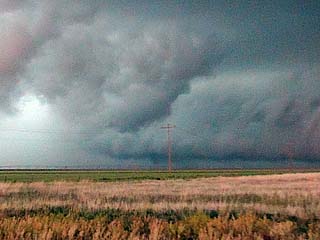
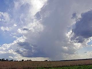
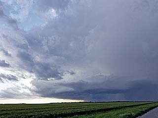
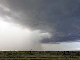
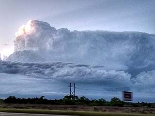
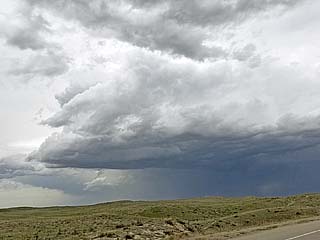
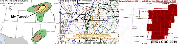
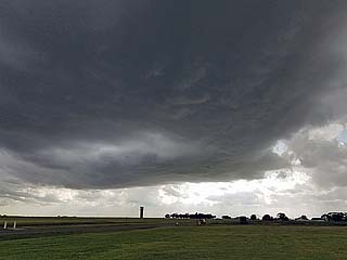
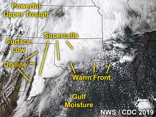
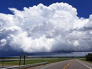
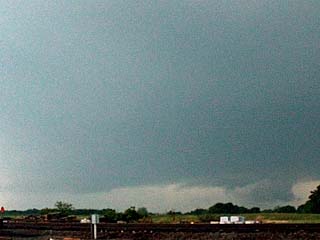
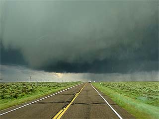
1). May 7, 5:30 PM - Interception and indirect penetration of an extremely severe and tornadic thunderstorm near Tulia, Texas in Swisher County, to the east of I-27 and Highways 275 and 207. The storm was a powerful HP storm that produced a large tornado near Tulia. The end of this tornado was observed during its wedge phase from near Wayside, Texas looking towards the WSW into the notch of the HP storm. The storm cycled and produced a second multi-vortex tornado north of Wayside before becoming rain wrapped. The storm evolved to a line / bowing segment thereafter. The HP storm also had a striking visual appearance, with intense FFD inflow banding (almost to ground level) as well as RFD and striations. Frequent lightning (with some close hits), torrential rains, 60 to 70 MPH winds, and hail up to 2" (the main core was avoided). The storm remained over open farmland so no damage was observed. Flash flooding was observed along Highway 207 in the Palo Duro Canyon. Conditions causing the storms were a dryline, outflow boundaries, surface heating, a low pressure system, and an upper trough. Documentation was digital stills and HD video. A 2016 Jeep Wrangler was used in this chase. A tornado watch was also valid for the area until 10 PM CDT.
2). May 8, 6:00 PM - Interception and observation of a strong to severe thunderstorms from near Beckham County, Oklahoma and Sayre, and southeastwards to near Blair in Jackson County, mainly near the vicinity of Highway 283. The storm was a small cluster of strong and severe storms that initiated in the far eastern TX Panhandle and into Oklahoma, some with supercell characteristics, especially near Sayre. Small hail, lightning, 40 MPH winds, and rotating wall clouds / funnels were observed with these storms. The cores were not penetrated. The storms continued to the southeast towards the Red River and weakened later in the evening near the OK / TX border. Conditions causing the storms were surface heating, a low pressure system, outflow boundaries (within a modified cool pool from earlier storms), a cold front, and an upper trough. Documentation was digital stills and HD time-lapse video. A 2016 Jeep Wrangler was used to chase the storms.
3). May 16, 5:00 PM - Interception and penetration of a severe thunderstorm in Box Butte County, Nebraska near Alliance and Highways 385 and SR 2. The storm was a small supercell storm that developed over that area and had rotation before down-scaling and dissipating. The storm had a small area of rotation, brief needle funnel, and small RFD cut / wall cloud. The storm was high based but an LP to classic supercell structure. Conditions observed were 40 MPH winds, heavy rains, hail to 1/2", and lighting as the storm core was penetrated as it was weakening. Some flooding was observed with this storm in Alliance as well. Conditions causing the storm were surface heating, up-slope wind flow, a frontal boundary, and approaching upper trough. Documentation was digital stills and HD video. A 2016 Jeep Wrangler was used to chase the storm.
4). May 17, 5:00 PM - Interception and observation of a severe thunderstorm north of Grant, Nebraska in Perkins County north of SR 23 and south of I-80. The storm was a supercell storm that developed ahead of a triple point / convergence area. This storm did not last long as it continued north of I-80 and down-scaled / merged with a line of storms. The core of this storm was not penetrated, and a small wall cloud was observed with the storm at peak intensity. The core had golfball sized hail or larger. Strong inflow winds of 45 MPH and lightning was encountered east of this storm. Conditions causing this storm were surface heating, a low pressure area, frontal boundary / dryline interactions, and an upper trough. Documentation was digital stills and HD video. A 2016 Jeep Wrangler was used to chase the storm. A tornado watch was also valid for the area until 9 PM MDT.
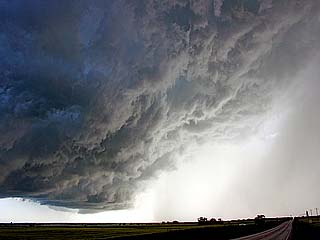
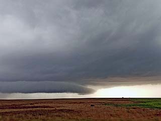
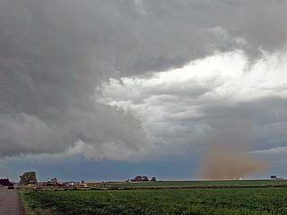
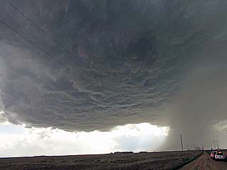
5). May 17, 6:30 PM - Interception and penetration of an extremely severe and tornadic thunderstorm in Frontier County, Nebraska from near SR 18 and 23, near Curtis and Farnam, and northeastward across I-80 to near Gotenburg and Highway 47. The storm was a cyclic supercell storm. Mainly classic mode from near McCook to Farnam, and HP like afterwards. The storm was penetrated as it was between cycles near Curtis and hail up to 1" was encountered with heavy rains, frequent lightning with close hits, and 60 MPH winds. At least 3 tornadoes were encountered with this storm, two of which highly visible and below a supercell with an impressive structure. Powerful RFD was encountered near Farnam, with gusts near 75 MPH and hail up to 2" as the tornado became rain wrapped. Damage was observed east of Farnam with downed powerlines, trees down, and some damage to outbuildings. The storm continued northeast past I-80 and continued to produce tornadoes until 8:30 PM, but these were less visible, before evolving to a line segment over the Nebraska sand-hills. Conditions causing the storm were surface heating, a dryline, low pressure system, and upper trough. Documentation was digital stills and HD video. A 2016 Jeep Wrangler was used to chase the storm. A tornado watch was also valid for the area until 10 PM CDT.
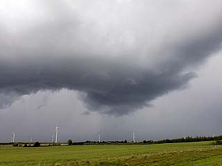
6). May 18, 6:00 PM - Observation and indirect penetration of a severe thunderstorm near Alva, Oklahoma in Woods County near Highways 64 and 281. The storm was initially a supercell storm that evolved to a line segment later on to the south and east near Carmen. Brief rotation was observed before the supercell evolved from LP to HP, then a bowing line segment. Conditions encountered were 50 to 60 MPH winds, frequent lightning, and heavy rains. Hail as large as 2" was seen in the roadway. The hail core was not directly penetrated. Conditions causing the storm were surface heating, a dryline, frontal / outflow boundary interactions, a low pressure system, and upper trough. Documentation was digital stills and HD video. A 2016 Jeep Wrangler was used to chase the storm. A severe thunderstorm watch was also valid for the area until 10 PM CDT.
7). May 18, 8:30 PM - Observation and brief penetration of a strong to severe thunderstorm along Highway 281 east of Waynoka in Woods County, Oklahoma. The storm was part of a line segment associated with a cold front and was penetrated during its weakening phase. Conditions encountered were 45 to 50 MPH winds, frequent lightning, heavy rains, and hail up to 3/4". Conditions causing the storm were surface heating, a Pacific cold front, a low pressure system, and upper trough. A 2016 Jeep Wrangler was used to penetrate the storm. A severe thunderstorm watch was also valid for the area until 10 PM CDT.
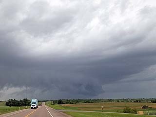
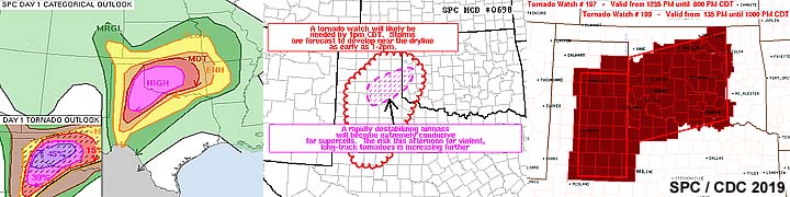
8). May 20, 3:30 PM - Interception, indirect penetration, and observation of a very severe and tornadic thunderstorm from near Paducah, Texas in Cottle County from along Highways 62 and 83, and near Highway 287 south of the Red River. The storm was a cyclic supercell storm, and a thin tornado was observed just north of Paducah and west of Highway 83. This was the same storm that would merge with a supercell to its immediate west, and later cycle again farther northeast near Magnum, OK (that was not reachable due to poor road options and fast storm motions). Other conditions encountered were 50 MPH winds, frequent lightning with close hits, heavy rains, and hail up to 2" (the main core was indirectly penetrated). Conditions causing the storm were surface heating, dryline / boundary interactions, a low pressure system, and intense upper level wave / jet stream aloft. Documentation was digital stills and HD video. A 2016 Jeep Wrangler was used to chase the storm. A PDS tornado watch watch was also valid for the area until 10 PM CDT.
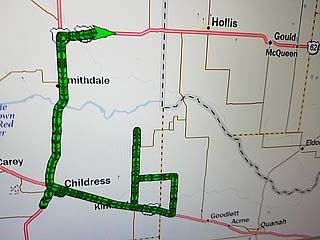
9). May 20, 5:00 PM - Observation and indirect penetration of a severe and thunderstorm near the intersection of Highways 62 and 83 in Childress County, Texas. The storm was an outflow dominant HP supercell storm that evolved to a bow / line segment. This became involved in a line / MCS of strong and severe storms as it moved east and northeast into western Oklahoma from along SR 30 north of Hollis and south of I-40. The core was not penetrated but a spectacular view of a dark, greenish tinted shelf cloud was noted west of Hollis, OK. 40 MPH winds, very heavy rains, small hail, and frequent lightning was also observed. Conditions causing the storm were surface heating, dryline / boundary interactions, a low pressure system, and intense upper level wave / jet stream aloft. Documentation was digital stills. A 2016 Jeep Wrangler was used to chase the storm. A PDS tornado watch watch was also valid for the area until 10 PM CDT.
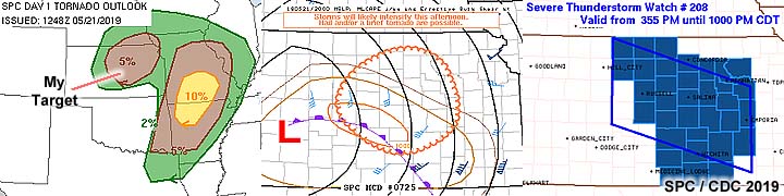
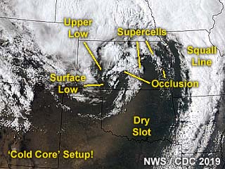
10). May 21, 3:00 PM - Observation and indirect penetration of a very severe and possibly tornadic thunderstorm from near Moundridge, Kansas in McPherson County east of I-35 and Highways 50 and 56. The storm was a small supercell storm with broad rotation developing on the southern end of a line segment of storms. This supercell storm was classic to HP in nature, with a small wall cloud and RFD cut. Lightning, heavy rains, 40 MPH winds, and hail up to 1" was encountered. The core was not directly penetrated. The storm was abandoned for another supercell to the west. Later on, and well to the northeast near Chapman, this same cell became tornado warned with a brief tornado reported. This possible tornado was not observed. Conditions causing the storm were surface heating, an occluded front, a low pressure system, and upper level low. This was a classic "cold core" setup. Documentation was digital stills. A 2016 Jeep Wrangler was used to penetrate the storm. A severe thunderstorm watch was also valid for the area until 10 PM CDT.
11). May 21, 4:00 PM - Interception and observation of a severe thunderstorm near Marquette, Kansas in McPherson County from north of SR 4 and southwest of the Smoky Hill Weapon Range. This storm was another classic to HP supercell storm developing near the cold occlusion front in a "cold core" environment. The core of this storm was not penetrated. A rotating wall cloud and funnel half way to the ground was observed with this storm as it was down-scaling and weakening due to stretching. A pronounced structure and RFD cut was noted with this storm. Conditions causing the storm were surface heating, an occluded front, a low pressure system, and upper level low. Documentation was digital stills. A 2016 Jeep Wrangler was used to penetrate the storm. A severe thunderstorm watch was also valid for the area until 10 PM CDT.
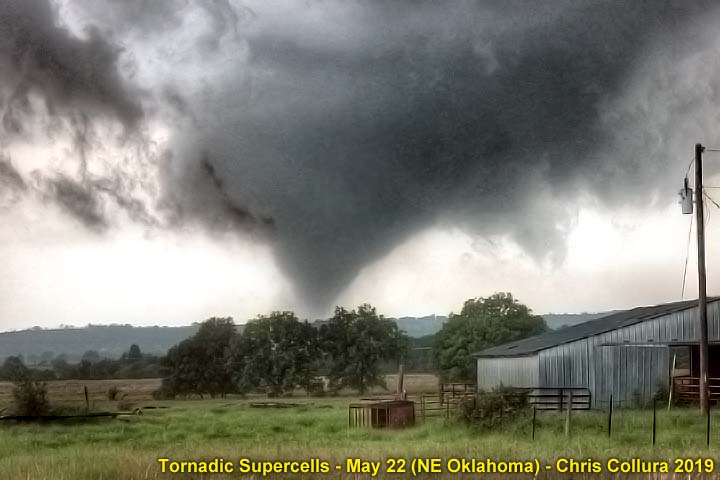
12). May 22, 5:30 PM - Interception and observation of an extremely severe and tornadic thunderstorm northwest of Henryetta and west of Okmulgee and Wilson near SR 56 in Okmulgee County, Oklahoma. The storm was a cyclic and classic supercell storm, and the full cycle of a large tornado was observed with this storm. The tornado was on the ground west of Wilson for nearly 30 minutes (large cone / stove-pipe) and was highly visible despite hilly terrain and haze. The supercell storm also had a striking visual appearance with striations and RFD slot. The storm continued northeast from near Morris, but only produced brief tornadoes. The storm core, containing baseball sized hail, was not penetrated. Other conditions encountered were moderate rains, 60 MPH winds (RFD), and frequent lightning. The storm was followed north and east until its down-scaling and dissipation near Chouteau, Oklahoma. The tornado remained over rural areas. Conditions causing the storm were surface heating, a stationary Pacific front, a low pressure trough, and an upper trough. Documentation was digital stills and HD video. A 2016 Jeep Wrangler was used to penetrate the storm. A PDS tornado watch was also valid for the area until 11 PM CDT.
13). May 22, 7:30 PM - Observation and indirect penetration of a very severe and possibly tornadic thunderstorm northwest of Chouteau and to near Pryor in Mayes County, Oklahoma from Highways 412 and 69 to near SR 20 and 82. The storm was a splitting HP supercell storm. The storm had a large wall cloud and if any tornado was produced it was rain wrapped near Pryor. The storm split and its southern component became a classic supercell that produced multiple funnels and rotating wall clouds. The storm had a striking structure and RFD. Conditions encountered were 50 MPH winds, small hail, heavy rains, and frequent lightning with some close hits. The storm was abandoned after dark for safety. Conditions causing the storm were surface heating, a stationary Pacific front, a low pressure trough, and an upper trough. A 2016 Jeep Wrangler was used to penetrate the storm. A PDS tornado watch was also valid for the area until 11 PM CDT.
14). May 23, 8:00 PM - Observation and indirect penetration of a very severe and possibly tornadic thunderstorm near Idalou, Texas in Lubbock County and near FM 400 and Highway 62. The storm was a classic supercell storm. A rotating wall cloud and funnels was observed with this storm. Other conditions encountered were frequent lightning, heavy rains, 60 MPH winds, and hail up to 1 inch while passing east of the storm. Conditions causing the storm were surface heating, dryline, a low pressure trough, and an upper trough. Documentation was digital stills and HD video. A 2016 Jeep Wrangler was used to penetrate the storm. A tornado watch was also valid for the area until 10 PM CDT.
15). May 23, 9:00 PM - Penetration of a very severe thunderstorm near Petersburg, Texas in Hale County along FM 54 and 789. The storm was a supercell storm that was producing very large hail as the boundary layer was decoupling during the late evening. Conditions encountered were frequent lightning with close hits, heavy rains, 60 MPH winds, and hail up to 2 inches. Hail fog was also observed. Conditions causing the storm were surface heating, dryline, a low pressure trough, and an upper trough. Documentation was digital stills and HD video. A 2016 Jeep Wrangler was used to penetrate the storm. A tornado watch was also valid for the area until 10 PM CDT.
16). May 24, 2:00 PM - Observation and penetration of a severe thunderstorm from south of Lubbock, Texas in Lubbock County from west of I-27 and northeast into NW Crosby County near Highway 62. The storm was a supercell storm that initiated early in the day and became outflow dominant. For a while the storm produced wall clouds before it became HP and was undercut by outflow / cold air. Very heavy rains, 60 MPH winds, frequent lightning, and 1 inch hail was encountered with this storm. Flooding was also observed. Conditions causing the storm were surface heating, a cold front, a low pressure trough, and an upper trough. Documentation was digital stills and HD video. A 2016 Jeep Wrangler was used to penetrate the storm. A tornado watch was also valid for the area until 9 PM CDT.
17). May 24, 4:00 PM - Interception, observation and penetration of a severe thunderstorm from west of Cap Rock, Texas in Crosby County along SR 207 and northward towards Crosbyton and Highway 62. This storm was originally a supercell storm that looked pretty good, producing wall clouds before it became HP and evolved to and merged with a large MCS. Torrential rains, 60 MPH winds, frequent lightning, hail up to 2 inches was encountered with these storms. Extensive flash flooding was also observed, with many roads impassible. Farming areas looked more like lakes in the wake of these training storms. Conditions causing the storms were surface heating, dryline / cold front interactions, a low pressure trough, and an upper trough. Documentation was digital stills and HD video. A 2016 Jeep Wrangler was used to penetrate the storm. A tornado watch was also valid for the area until 9 PM CDT.
18). May 25, 2:30 PM - Indirect penetration of a strong to severe thunderstorm in Moore County, Texas along Highway 87 south of Dumas. The storm was a small supercell storm developing on the eastern side of a large area of strong and severe thunderstorms. Lightning, 40 MPH winds, light rain, and 3/4 inch hail was observed passing west of the storm core. Conditions causing the storms were surface heating, boundary interactions, a low pressure trough, and an upper trough. Documentation was digital stills and audio. A 2016 Jeep Wrangler was used to observe the storm. A tornado watch was also valid for the area until 10 PM CDT.
19). May 25, 6:30 PM - Interception, observation, and direct penetration of a very severe and tornadic thunderstorm near Brice, Texas in Hall and Briscoe counties along SR 256. The storm was an HP supercell within a cluster of HP storms. A brief but rain wrapped tornado was encountered at close proximity along SR 256 with this storm. Easterly winds increased to near 60 MPH in heavy rains rapidly shifting to NW at over 70 MPH in a brief area. No visible funnel was visible. Frequent lightning with close hits, torrential rains, and hail to 1 inch was also encountered. The storm evolved to a bow segment before it moved east. Conditions causing the storms were surface heating, dryline / outflow boundary interactions, a low pressure trough, and an upper trough. Documentation was digital stills. A 2016 Jeep Wrangler was used to penetrate the storm. A tornado watch was also valid for the area until 10 PM CDT.
20). May 26, 2:00 PM - Interception, observation, and indirect penetration of a very severe thunderstorm near Springfield, Colorado in Baca County near Highways 287 and 160. The storm was a classic to HP supercell storm. The core was not directly penetrated but the east side of its fringes brushed me with hail up to 3/4 inches falling. The storm also contained frequent lightning, heavy rains, and winds near 40 MPH on its edges. A large wall cloud was noted when the storm evolved from classic to HP mode. After about an hour, the storm moved quickly northeast and down-scaled and basically disappeared after following it on a horribly muddy road between Highway 160 and SR 116 to the north. Conditions causing the storms were surface heating, dryline / boundary interactions, a low pressure trough, and an upper trough. Documentation was digital stills and HD video. A 2016 Jeep Wrangler was used to chase the storm. A tornado watch was also valid for the area until 9 PM MDT (10 PM CDT).
21). May 26, 5:30 PM - Interception, observation, and indirect penetration of a very severe thunderstorm from near Lamar / Wiley, Colorado in Prower County near Highways 287 and 50 to points north and east to near Sharon Springs, Kansas near Highways 40 and 385. The storm was a classic supercell storm at first, but eventually evolved to HP, and a line / bow segment in western Kansas. The core was not directly penetrated. Frequent lightning, heavy rains, small hail, and winds near 50 MPH was encountered around the storm. A large wall cloud / funnels were also noted when this storm. The storm had a pronounced RFD region as well. The storm also produced a rain wrapped tornado later on near Sharon Springs, but that was not observed. Conditions causing the storms were surface heating, boundary interactions, a low pressure trough, and an upper trough. Documentation was digital stills and HD video. A 2016 Jeep Wrangler was used to chase the storm. A tornado watch was also valid for the area until 9 PM MDT (10 PM CDT).
22). May 27, 2:00 PM - Interception, observation, and indirect penetration of a very severe and tornadic thunderstorm to the north of Fort Morgan, Colorado in Morgan County, and north of I-76 / Highway 34 and SR 71 near Brush. The storm was a supercell storm that developed slowly and earlier north of the Palmer Divide to the southwest and moved into the area, before becoming HP and outflow dominant. The storm produced a couple of brief tornadoes / gustnadoes as it was north of Brush. These were observed at close range, with swirling clouds of dust before RFD surged out. The storm core was not directly penetrated. Small hail, frequent lightning, moderate rains, and frequent lightning was also observed with this storm. Conditions causing the storms were surface heating, up-slope wind flow, boundary interactions, a low pressure trough, and an upper trough. Documentation was digital stills and HD video. A 2016 Jeep Wrangler was used to chase the storm. A tornado watch was also valid for the area until 9 PM MDT (10 PM CDT).
23). May 27, 8:00 PM - Observation and indirect penetration of an extremely severe and tornadic thunderstorm from its point of initiation south of Otis / Yuma Colorado, and northeastward near and south of Holyoke in Yuma County near SR 59 and Highway 34, and northeastward to along Highway 6 into Chase County, Nebraska to near Imperial. The storm began as a convective shower, then grew into an LP to classic supercell with a high base north of Yuma, Colorado. As the storm intensified as per intensification of the low level jet and arrival of upper level support, the storm became a violent HP supercell as it entered Chase County, Nebraska. This supercell produced a brief tornado just south of Phillips County, Colorado. The storm core was indirectly penetrated, but hail up to 2 inches was observed. Frequent lightning with some close hits, torrential rains, and winds over 70 MPH were encountered with this storm. The supercell also produced a large multi-vortex tornado, with low contrast, visible in the HP "notch" of the storm. This supercell had an impressive and striking visual appearance, with the forward flank exhibiting powerful inflow banding / stream-wise vorticity "rotor" as well as multiple striations and "stacked plates" vertical structure. Inflow winds gusting to near 50 MPH were encountered. The RFD region of this storm was penetrated, with a brief view of the tornadic area to the north, while standing in 70 to 80 MPH RFD winds. Conditions causing the storms were surface heating, up-slope wind flow, boundary interactions, a low pressure trough, and an upper trough. Documentation was digital stills and HD video. A 2016 Jeep Wrangler was used to chase the storm. A tornado watch was also valid for the area until 9 PM MDT (10 PM CDT).
24). May 28, 6:30 PM - Long range interception and observation of an extremely severe and tornadic thunderstorm from 20 or 30 miles distance. The storm was over Osborne and Mitchell counties, Kansas from Luray to Beloit, and significant tornadoes were produced by the storm. These tornadoes were not observed (except maybe a brief long range glimpse of one) and the storm weakened to a line segment after driving nearly an hour and a half to get to it. The storm core, probably containing large hail and high winds, was not penetrated. RFD winds gusting near 60 MPH were encountered, with lightning and light rain observed before the storm weakened due to outflow. Conditions causing the storm were surface heating, a warm front, Pacific cold front / dryline, low pressure area, and upper trough. Documentation was digital stills and HD video. A 2016 Jeep Wrangler was used to chase the storm. A tornado watch was also valid for the area until 10 PM CDT.
25). May 28, 8:00 PM - Observation and penetration of a severe and thunderstorm along Highway 24 in Clay and Riley Counties, Kansas from near Clay Center to Randolph near Highway 77 and SR 16. The storm was a small supercell storm that developed in a region of confluence in the area, and quickly became severe. Large hail (up to 2 inches), frequent lightning, heavy rains, and 60 MPH winds were observed with this storm. An area of rotation with a wall cloud and RFD cut / funnels was also observed near Riley, but the storm quickly weakened after that and became a line segment due to outflow. Conditions causing the storm were surface heating, a Pacific cold front, low pressure area, and upper trough. Documentation was digital stills and HD video. A 2016 Jeep Wrangler was used to chase the storm. A tornado watch was also valid for the area until 10 PM CDT.
26). May 29, 7:30 PM - Interception, penetration, and observation of severe and tornadic thunderstorms over Iowa County, Iowa near Williamsburg and north of I-80 west of Iowa City. The storm began as a small supercell storm that split into at least another during its cycling along I-80 and Highway 6. These small supercell storms produced numerous funnel clouds and a couple of tornadoes which were observed. Heavy rains, small hail to 3/4 inch, occasional lighting, and 60 MPH winds were also encountered. The tornadoes were brief but photogenic, as the supercell storms were LP to classic in nature. At least one supercell had a striated appearance and well developed RFD slot. Conditions causing the storm were surface heating, an occluded front (arcing confluence / shear axis), surface low, and upper level low (basic cold-core setup). Documentation was digital stills and HD video. A 2016 Jeep Wrangler was used to chase the storms.
27). June 1, 3:30 PM - Interception, penetration, and observation of strong to severe thunderstorms in Rock County, Wisconsin along I-39 near Janesville and north of Beloit. The storm was originally an HP supercell tht evolved to a multicell cluster of strong and severe thunderstorms. Conditions encountered were 60 MPH winds, frequent lightning, very heavy rains, and hail up to 3/4 inches. Conditions causing the storms were surface heating, a weak low pressure area, a Pacific cold front, warm front, and upper trough. Documentation was digital stills and audio. A 2016 Jeep Wrangler was used to chase the storm. A severe thunderstorm watch was also valid for the area until 9 PM CDT.
28). June 14, 5:30 PM - Interception and observation of a severe thunderstorm north of Manter, Kansas in Stanton County and near Walsh, Colorado in Baca County, and along Highway 160 and SR 89. The storm was an elevated / high base supercell storm developing ahead of a cluster of strong and severe storms. This storm had an area of rotation with some high-based funnels. There was a pronounced RFD as well, with dust being kicked up and gustnadoes. The core of the storm was not penetrated (but contained 1" hail). Heavy rains, 50 MPH winds, and frequent lightning was encountered. The storms were caused by a surface heating, low pressure area, dryline, up-slope wind flow, and a weak upper trough. Documentation was digital stills. A 2016 Jeep Wrangler was used to chase the storm. A severe thunderstorm watch was also valid for the area until 9 PM MDT (10 PM CDT).
29). June 15, 8:30 PM - Interception, indirect penetration, and observation of a very severe and tornadic thunderstorm over Custer County, Oklahoma near SR 47 west of Highway 183 and near SR 33 and Custer City (35 miles north of Clinton). The storm was a powerful HP supercell storm, developing on the south side of a cluster of strong and severe thunderstorms. After a storm split earlier north of Putnam, the southern supercell turned right and became the dominant "tail-end Charley" storm. This supercell was classic to HP, and contained large hail, extremely heavy rains, and frequent lightning. A large tornado (cone to wedge) was observed with this storm looking northwest from near Custer City in twilight, illuminated by lightning. The tornado did damage south of Putnam and was confirmed. The supercell also had a striking visual appearance, with striations and a "stacked plates" / "space ship" effect. The core was not directly penetrated, but the south side and wet RFD area was encountered with winds gusting over 80 MPH. The storm evolved to an intense bow / line segment (upscale growth) and produced winds over 90 MPH in Clinton, Oklahoma. I stopped to assist in a near fatal accident with people trapped in a burning car at the intersection of Highway 183 and I-40 passing into Clinton. The most dangerous part of the storm missed Clinton to the north. Conditions causing the storm were surface heating, a stationary frontal / outflow boundary, dryline to the far west, a weak low pressure area, and an upper trough. Documentation was digital stills and audio. A 2016 Jeep Wrangler was used to chase the storm. A severe thunderstorm watch was also in effect for the area until 10 PM CDT.
30). June 16, 1:00 PM - Penetration of a strong to severe thunderstorm in Shackelford County, Texas along Highway 183 north of Albany. The storm was a multicell cluster of storms, including a small elevated supercell, developing on the north side of an outflow boundary across the region. This storm also contained heavy rains, frequent lightning with some close hits, 50 MPH winds, and hail up to 1". Documentation was digital stills and audio. Conditions causing the storms were surface heating, an outflow boundary, a low pressure trough, and upper trough. A 2016 Jeep Wrangler was used to chase the storm.
31). June 16, 5:30 PM - Interception, indirect penetration, and observation of a very severe thunderstorm from southwestern Callahan County, Texas and southeastward into Coleman County north of Santa Anna and near Highways 84 and 67. The storm was a classic to LP supercell storm. An area of strong rotation was observed with this storm, with a high base wall cloud and distinct RFD cut. A large funnel cloud was also observed with the storm as it began downscaling to the northwest of Santa Anna. After that the storm continued downscaling until it basically vanished. During the most intense phase of the storm, the core was indirectly penetrated, and hail to 1.5" was observed, along with moderate rain, gusty winds to 40 MPH, and frequent lightning with some close hits. Documentation was digital stills. Conditions causing the storms were surface heating, an outflow boundary, a low pressure trough, and upper trough. A 2016 Jeep Wrangler was used to chase the storm. A severe thunderstorm watch was also valid for the area until 8 PM CDT.
32). June 17, 5:30 PM - Interception, penetration, and observation of a very severe thunderstorm near Muleshoe, Texas in Bailey County near Highway 70 and SR 214. The storm was an LP (low precipitation) supercell storm. Conditions encountered were 40 MPH winds, light rain, frequent lightning with some close hits, and hail to 1.5" (half dollar to golfball sized). The storm had a striking visual appearance, although being high based, with striations and a flared out base ("bell" shaped). A prominent hail "roar" was also audible with this storm. The storm moved very slowly and cycled up and down several times near Muleshoe, and eventually evolved to a multicell cluster of storm. Conditions causing the storms were surface heating, up-slope wind flow, boundary interactions, and a weak surface and upper trough to the west. Documentation was still photos and HD video. A 2016 Jeep Wrangler was used to chase the storm. A severe thunderstorm watch was also valid for the area until 9 PM MDT (10 PM CDT).
33). June 18, 3:00 PM - Interception, penetration, and observation of a very severe and tornadic thunderstorm to the northwest of Kinsley, Kansas in Hodgeman and Edwards Counties from near Highways 50 and 183 and west of Highway 56. The storm was a classic supercell storm, and two brief tornadoes were observed from a distance of about 5 to 10 miles as the storm was approached from the southeast. A large wall cloud with funnels was also observed, as well as a gust front extending from the RFD region and southwestward (this meant the storm was "anchored" on an outflow boundary). The storm also contained lightning, heavy rains, 50 MPH winds, and large hail, but the core was not penetrated. Some tree damage was noted after the storm became outflow dominant and began down-scaling, most likely from one of the brief tornadoes, and / or RFD winds. One tornado was an elephant trunk type, while the other was a thin needle type. Documentation was digital stills and HD video. Conditions causing the storms were surface heating, an outflow boundary, a low pressure area (particularly an MCV), and upper trough. A 2016 Jeep Wrangler was used to chase the storms. A tornado watch was also in effect for the area until 10 PM CDT.
34). June 18, 6:00 PM - Observation and indirect penetration of very strong and severe thunderstorms in Sumner County, Kansas from north of Conway Springs and east of Harper, and along Highways 54 and 160 to near Wellington. The storm was originally a supercell storm, but it became outflow dominant and was mainly a large multicell cluster at the southwestern end of a squall line. Small hail to marble sized, 60 MPH winds, lightning, and very heavy rains were encountered with these storms. Street / flash flooding was also encountered. Documentation was digital stills. Conditions causing the storms were surface heating, an outflow boundary, a low pressure trough, and upper trough. A 2016 Jeep Wrangler was used to chase the storms. A tornado watch was also in effect for the area until 10 PM CDT.
35). June 19, 5:30 PM - Observation and indirect penetration of a very severe and possibly tornadic thunderstorm over Hunt County, Texas from north of Farmersville near Merit, and near Highways 380 and 69, and past Greensville to near Emory. The storm was an HP supercell storm, that was observed from near its point of initiation, and the majority of its life cycle. This storm had a powerful mesocylone, with strong rotation with wall clouds / funnels, especially early in its life cycle before becoming more outflow dominated and / or "rain wrapped" HP. Tree and sign damage was observed with this storm, and part of the weak tornado may have been penetrated on the southeast side of Greenville along Highway 69, with airborne tree debris observed and "tagging" rain curtains. Other conditions were winds over 75 MPH, heavy rains, frequent lightning with some close hits, and hail to 2". The main core, with baseball sized hail, was not directly penetrated. Documentation was digital stills and HD video. Conditions causing the storms were surface heating, an outflow boundary, a low pressure trough, and upper trough. A 2016 Jeep Wrangler was used to chase the storms. A tornado watch was also in effect for the area until 12 AM CDT the following day.
36). June 20, 7:30 PM - Interception, penetration, and observation of a severe thunderstorm near Marshall and Nemaha Counties in Kansas and along SR 9 from near Vermillion to Corning. The storm was an LP supercell storm. This storm had a striking visual appearance during its maturity, including the "stacked plates" and striations. The core was penetrated during the early stages of the storm, and hail up to 1.5" was observed. The storm also contained light to moderate rain, frequent lightning with some close hits, and winds near 45 MPH mainly in RFD gusts. The storm had a small RFD and rotating all cloud with some small funnels. Conditions causing the storms were surface heating, possible boundary interactions, and a weak surface trough with departing upper trough to the east. Documentation was still photos and HD video. A 2016 Jeep Wrangler was used to chase the storm.
37). June 21, 3:30 PM - Interception, observation, and indirect penetration of a very severe and tornadic thunderstorm from southwest of Kiowa, Colorado in Elbert County near SR 86 and southeastwards via I-70 through Limon along Highways 71 and 94 to Highway 40 near Wild Horse. The storm was a classic to HP supercell storm. A rapidly rotating wall cloud was noted on the southern end of this storm near Kiowa early in its life-cycle. Swirling dust under this feature confirmed a possible brief tornado. Conditions encountered were also frequent lightning, heavy rains, 60 to 70 MPH winds, and hail up to 1.5". The core was indirectly penetrated. Conditions causing the storms were surface heating, up-slope wind flow, post frontal troughing, and an upper trough. Documentation was still photos, audio, and HD video. A 2016 Jeep Wrangler was used to chase the storm. A severe thunderstorm watch was also valid for the area until 8 PM MDT (9 PM CDT).
38). June 21, 8:00 PM - Observation and direct penetration of a very severe and possible tornadic thunderstorm from near Kit Carson, Colorado and eastward along Highway 40 through Arapaho in Cheyenne County and eventually into Kansas in Sharon Springs in Wallace County. The storm was an HP supercell / line bow segment, with extremely powerful straight-line winds. The storm had a striking visual appearance and multi-tiered shelf cloud during its bow segment phase. Conditions encountered were frequent lightning with some close hits, heavy rains, copious amounts of 1" hail with isolated 2" pieces, and most importantly, winds approaching or even exceeding 100 MPH at a gas station in Sharon Springs. Damage was observed to signs, roofing, and trees from this storm. Many car windows were blown out by the wind driving hail and debris such as pebbles. My vehicle had its rear window blown out, despite having a hail grill on it, and my phone on the dashboard had its screen shattered. Sand, broken glass, and gravel was strewn inside my vehicle. I also had small cuts on my feet from flying gravel / hail. Conditions causing the storms were surface heating, up-slope wind flow, post frontal troughing, and an upper trough. Documentation was still photos and HD video. A 2016 Jeep Wrangler was used to chase the storm. A severe thunderstorm watch was also valid for the area until 11 PM MDT (12 AM CDT the following day).
39). June 22, 6:30 PM - Observation and indirect penetration of severe thunderstorms near Chester, Oklahoma in Major County and near Highways 60 and 283. The storm was a multicell cluster of strong and severe storms, with some supercell structures. One such transient supercell had a lower base / wall cloud with some small funnels observed. The storm also contained hail, but the core was not directly penetrated. Small hail, light to moderate rain, 40 MPH winds, and frequent lightning was observed. Conditions causing the storms were surface heating, a weak Pacific Cold front, low pressure trough, and an upper trough to the west. Documentation was digital stills and HD video. A 2016 Jeep Wrangler was used to chase the storms. A severe thunderstorm watch was also in effect for the area until 10 PM CDT.
40). June 23, 5:00 PM - Interception and indirect penetration of strong to severe thunderstorms anywhere from Waurika, Oklahoma and southward along Highway 81 and southwestward into Clay County, Texas in Clay County and near Highway 82 and east of Highway 281. The storms were a large line of strong and severe storms extending from SW Texas into southeastern Oklahoma, with isolated areas of embedded weak rotation, but outflow dominant. Conditions encountered were heavy rains, small hail, frequent lightning with some close hits, and winds gusting near 50 MPH. The cores of these storms were not penetrated directly. Conditions causing these storms were surface heating, an outflow boundary / stalled Pacific cold front, low pressure trough, and upper trough to the northwest. Documentation was digital stills. A 2016 Jeep Wrangler was used to chase the storms. A severe thunderstorm watch was also in effect for the area until 10 PM CDT.
41). June 25, 4:30 PM - Interception and observation of a very severe thunderstorm near Davenport, Nebraska in Nuckolls and Thayer Counties near SR 4 and 14, and north of Highway 136. The storm was an LP storm that split and down-scaled afterwards. The storm was producing large hail but the core was not intercepted. The storm also had a striking visual appearance with a "barber pole" type updraft. Conditions encountered near the storm were 40 MPH winds, frequent lightning, and light rain. Conditions causing the storms were surface heating, a nearly stationary frontal boundary, a weak surface trough, and upper trough. Documentation was still photos. A 2016 Jeep Wrangler was used to chase the storm. A severe thunderstorm watch was also valid for the area until 9 PM MDT (10 PM CDT).
42). June 25, 6:00 PM - Interception and observation of a very severe thunderstorm northwest of superior, Nebraska in Nuckolls and Clay Counties near SR 4 and 14, and east of Highway 281. The storm was an HP supercell storm that evolved into a cluster of severe thunderstorms via upscale growth. The storm was producing very large hail but the core was not intercepted. Conditions encountered near the storm were 50 MPH winds, frequent lightning with some close hits, small hail, and heavy rain. Conditions causing the storms were surface heating, a nearly stationary frontal boundary, a weak surface trough, and upper trough. Documentation was still photos. A 2016 Jeep Wrangler was used to chase the storm. A severe thunderstorm watch was also valid for the area until 9 PM MDT (10 PM CDT).
43). June 26, 7:00 PM - Observation and penetration of a severe thunderstorm from its point of initiation west of Aurora, Illinois in Kane County and eastward into Dupage County near Highway 30 and I-88 to Naperville. The storm was a cluster of severe thunderstorms, with transient supercell structures. An area of slight rotation was noted near Aurora before the storm got undercut by its outflow cool pool. During the storm penetration, frequent lightning with some close hits, very heavy / torrential rains, and hail to 1" was encountered. A report of 2" hail was confirmed with this storm in extreme western Cook county nearby. Conditions causing the storms were surface heating, a low pressure trough, upper trough, and a lake breeze boundary. Documentation was still photos and audio. A 2016 Jeep Wrangler was used to chase the storm.
44). July 8, 5:30 PM - Observation of strong to severe thunderstorms along I-80 near Cozad, Nebraska in Dawson County. The storm was a multicell cluster of strong and severe thunderstorms and was penetrated while headed west on the interstate wrapping up chasing. Conditions encountered were 50 to 60 MPH winds, heavy rains, lightning, and small hail. Conditions causing the storm were surface heating, a convergence area / boundary, low pressure trough, and upper trough. Documentation was digital stills. A 2016 Jeep Wrangler was used to chase the storms. A severe thunderstorm watch was also valid for west of the area until 11 PM CDT.
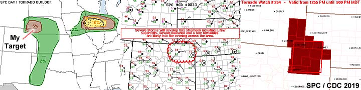
This concludes the chase log for the central US Plains for the main chase "expedition" of 2019 starting May 7 and ending on July 11. The summary includes a total of 44 observations, out of which there all were 44 severe thunderstorms. Out of these thunderstorms, as many as 22 tornadoes were observed. A 2016 Jeep Wrangler vehicle was used in all 44 of the chases / observations above. All entries for the logs above are for the local time zone unless otherwise noted. This information was prepared exclusively for the National Weather service and the team of Skywarn storm spotters.

|
The long chase stints in 2019 officially began when I left Florida on May 6, 2019 (after already missing activity in the central USA the past few days). I was supposed to leave May 7, but changed my air ticket to leave earlier. In this picture, I am flying from Fort Lauderdale to Austin, Texas, and passing some beautiful cumulonimbus clouds associated with the sea breeze activity over south Florida. |
|
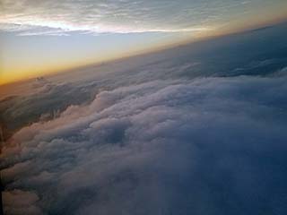
After leaving Florida and stopping in Austin, Texas, I continue flying from there to Los Angeles, California. In this picture the distinct shortwave trough (providing upper level support for severe storms over the central USA) can be seen where the high layer of clouds suddenly stops as you proceed westward. Below us is the low level stratus and stratocumulus clouds associated with the boundary layer moisture / low level jet during the evening of May 6. This moisture will eventually cause severe storms I will be chasing in the Texas panhandle a mere 24 hours later. My plan is to get into LA, hit the ground running, and pull an "all nighter" driving to Texas the following day to chase! |

|
While heading east out of the Los Angeles area and into the Mojave Desert on I-40 (between Barstow and Needles, California) there is a truck stop / gas station near Essex, California. Please plan NOT to STOP here! Look at the price for regular unleaded (yes, that's right at nearly 5.87 a gallon!) - Premium was $6.05 as of May 6! This place, called the "Sahara Oasis", gouges prices on everything - Even candy and bottled water. If you park there it's $10 to park. If you need to use the restrooms, you NEED TO BUY something first. It's in the middle of the desert so they can get away with this. In this case I just put a few bucks of gas in to make it to a gas station 50 miles to the east, where it was a more "normal" $4 a gallon for California! If crossing this section of I-40, make sure you top off in Needles / Ludlow or Barstow, so you DON'T have to stop here. |

|
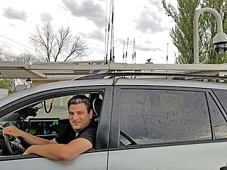
Here is a picture of myself driving. May 6 to 7 of 2019 was a long drive, without sleep, from southern California to the western Texas Panhandle. Not sure how I did it, but I did! |
|
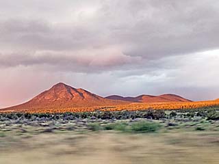
Early morning, and with continued driving through the night, on May 7, 2019 - I am treated to this beautiful view passing through Arizona and New Mexico. |
|
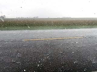
Light wet snow falls in the highlands of New Mexico and Arizona early in the morning on May 7. The "cold core" of an intense upper level disturbance causes the freezing level to become very low with snow as low as 7,000 feet above sea level. |
|
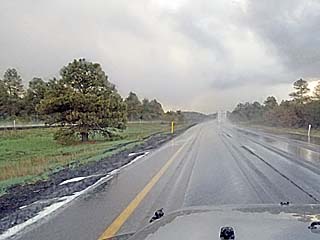
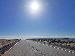
After experiencing light wet snow earlier in the highlands of New Mexico and Arizona, the sky gives way to clear sunshine and dry air as I am in the middle of a long, non-stop drive from California to Texas on May 7. |

|
This is the backside of the upper level disturbance, marked by high clouds, as I continue east into New Mexico near Albuquerque on May 7. This wave is racing east and will provide important upper level support for severe weather later on in the Texas Panhandle. |
|
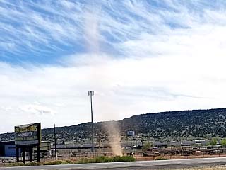
A dust devil churns on the north side of I-40 while heading through eastern New Mexico en-route to the Texas Panhandle on May 7. |
|
The sky becomes rather bizarre with asperatus looking clouds as the axis of the upper trough is crossed as I continue east on I-40 across eastern New Mexico and approaching the Texas border on May 7. This is due to turbulence and large scale ascent associated with the exit region of the upper wave. |
|
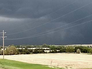
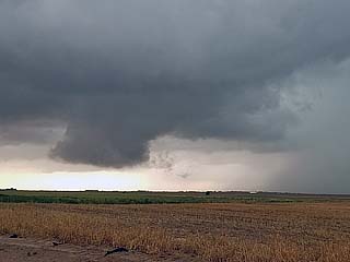
View looking east at one of several supercells being visually confirmed from the west of Amarillo at about 5 PM CDT on May 7. This was after finally reaching the dryline boundary and well ahead of the upper trough axis. |
|
Rotating area (and funnel) on a supercell to the west of Amarillo as the first storms are directly encountered at roughly 5:15 PM CDT on May 7. |
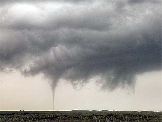
|
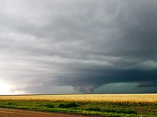
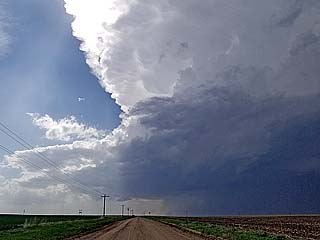
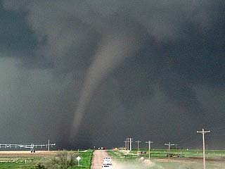
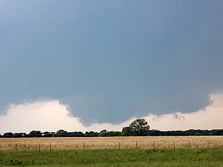
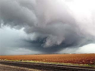
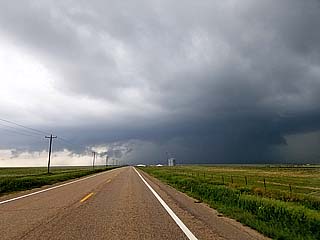
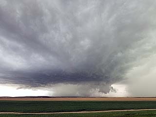
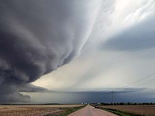
First good view of the Tulia, Texas supercell at roughly 5:40 PM CDT from near Wayside, Texas on May 7. The view is to the southwest and looking directly and the HP "notch" of the HP storm. |
|
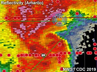
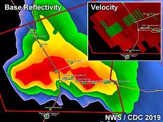
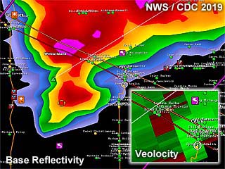
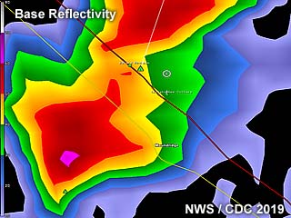
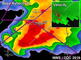
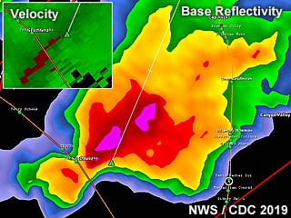
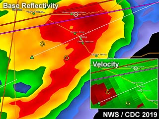
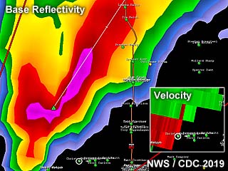
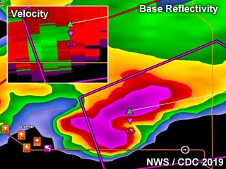
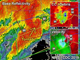
Base reflectivity of the Tulia, Texas supercell at about 5:40 PM CDT on May 7 off the Amarillo radar. My position is the blue cross-hair, and directly in the path of a rain wrapped tornado. Red dots are other storm chasers. |
|
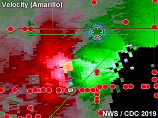
Doppler velocity of the Tulia, Texas supercell at about 5:40 PM CDT on May 7 off the Amarillo radar. My position is directly in the path of the velocity couplet. |
|
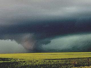
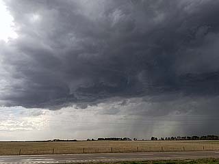
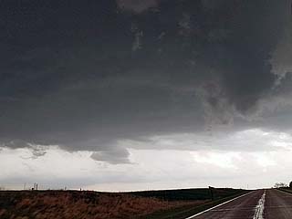
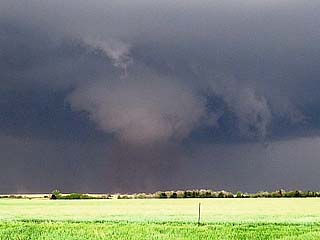
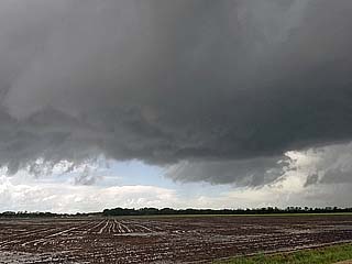
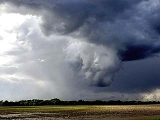
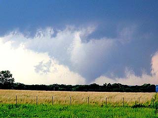
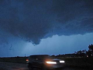
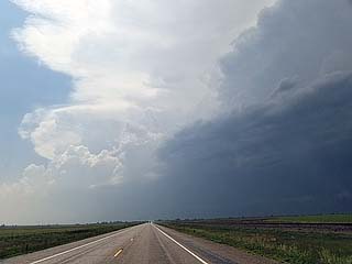
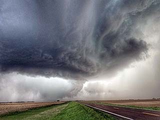
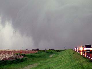
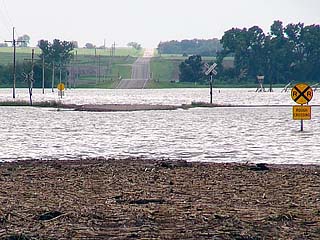
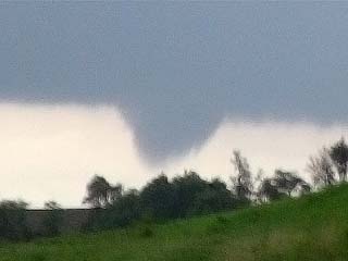
View of approaching HP supercell with the late states of a wedge tornado near Tulia, Texas on May 7 at roughly 5:45 PM CDT. The view, taken from south of Wayside, is to the southwest and directly into the HP "notch" of the supercell, and between the wet RFD (to the far left), and forward flank precipitation (to the right). |
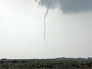
|
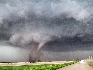
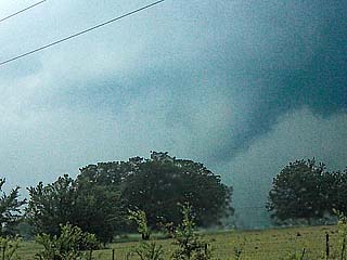
Close up view of the late stages of the wedge / multi-vortex tornado as is passes to the north of Tulia, Texas on May 7 at around 5:50 PM CDT. |
|
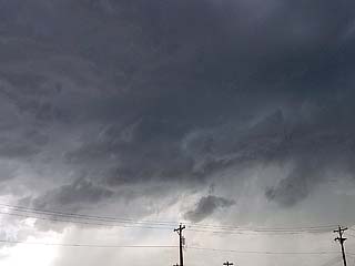
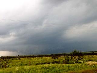
Looking towards the west from south of Wayside, Texas, the incredible stream-wise vorticity current along the supercell FFD (forward flank downdraft) screams from right to left into the main updraft. The horizontal tube, or "rotor", is marked by ground scraping low clouds as it is pulled into the storm as it cycles up again late on May 7. |
|
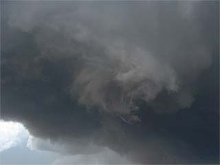
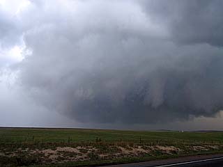
The RFD and FFD meet in the so called "notch" of the HP supercell as it cycles up again near Wayside, Texas. The view is to the southwest and west. A multi vortex tornado is developing, and a suction vortex can be seen in the center of the picture just to the left of the pole. This was around 6 PM on May 7 in Swisher County. |
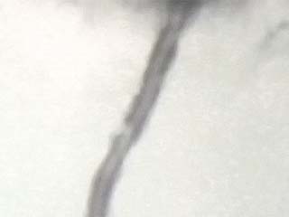
|
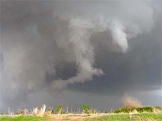
Close up of low contrast, multi vortex tornado near the FFD and RFD occlusion as the storm continued northeast near Wayside on May 7. |
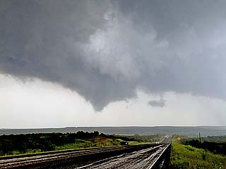
|
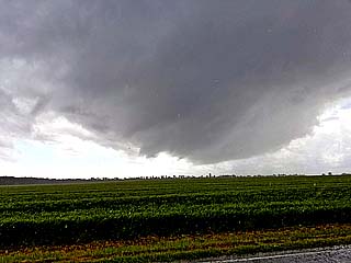
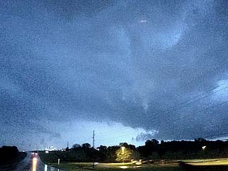
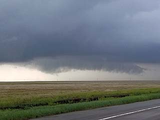
While rushing east on a muddy road in 4x4 mode, I am headed south of Wayside approaching Highway 207. Looking over and back to the southwest, the mesocyclone and HP "notch" can be seen. The RFD is wrapping around from the left side, with the low level circulation to the center and right of the photo. Isolated tennis ball sized hail was falling at this point on May 7. |
|
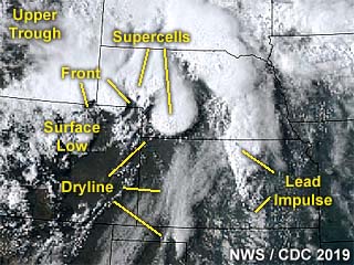
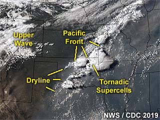
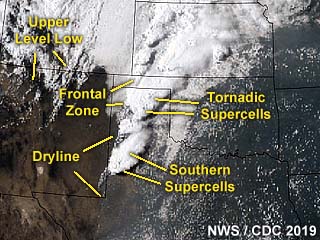
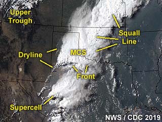
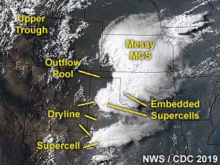
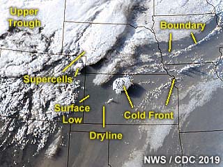
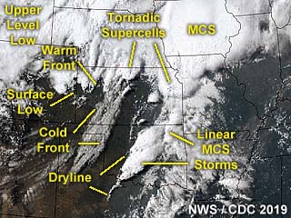
Annotated satellite image showing the synoptic setup as well as supercell storms over the Texas Panhandle at around 23z on May 7. |
|
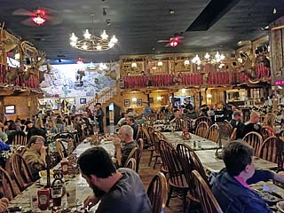
After a long chase day and unforgettably tiring drive, I am indulging in a steak dinner at the Big Texan steakhouse in Amarillo as a hail storm rages outside during the evening of May 7. |
|
Initiation of storms near the TX / OK border and north of I-40 viewed from Highway 283 looking towards the northwest during the afternoon of May 8, 2019. |
|
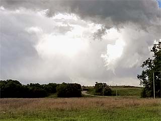
Small low precipitation supercell storm going up near Sayre, Oklahoma during the afternoon of May 8. |
|
Rotation with RFD cut and small funnel near Dempsey, Oklahoma on May 8. |
|
Supercell storm becoming outflow dominant near Cheyenne, Oklahoma on May 8. |
|
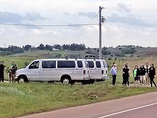
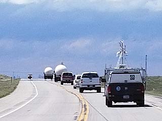
Storm chasing tour group vans observing the storms near Berlin, Oklahoma on May 8. |
|
View of supercell storm as it was near Willow, Oklahoma on May 8. |
|
View of hail core of supercell storm as it was passing near Willow, Oklahoma on May 8. |
|
Impressive view of the supercell storm as it was near Frederick, Oklahoma from Highway 287 east of Vernon, Texas during the evening of May 8. |
|
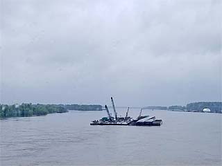
Crossing a very swollen Mississippi River south of Saint Louis, Missouri and into Illinois en-route to Chicago for some down time on May 10. |
|
I get it that not many people stay at this motel near Marston, Missouri? |
|
Back across the Mississippi River near Davenport, Iowa and from Illinois and into Iowa en-route to Nebraska on May 15. |
|
Driving along I-80 through Kearney and near the Archway Monument in central Nebraska en-route to the Nebraska Panhandle for the next round of storms on May 16, 2019. |
|
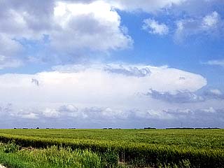
Small supercell building, with flanking line, to the southwest of Alliance, Nebraska during the late afternoon of May 16. |
|
This is a radar image of the small supercell that developed near Alliance, Nebraska during the late afternoon on May 16, 2019. The base reflectivity image is shown as well as the velocity in the inset to the upper right. |
|
Rain free base and updraft region (with weak rotation) near Alliance, Nebraska on May 16. |
|
Close up view of weak rotation area in the rain free base of the small supercell near Alliance, Nebraska on May 16. The storm is just starting to weaken and becoming outflow dominant at this point. |
|
Marble sized hail falling north of Alliance, Nebraska on May 16 as the storm starts to quickly weaken afterwards. |
|
I had the pleasure of running into Dan Shaw from Australia in Alliance, Nebraska on May 16! |
|
View east of another high-based severe storm to the east while heading south on Highway 385 towards Sidney, Nebraska on May 16 for dinner. |
|
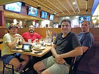
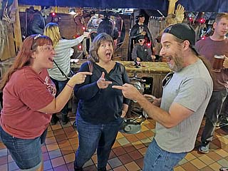
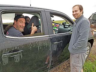
Chaser dinner at Applebees restaurant in Sidney, Nebraska. From left to right is Tom Hinterdorfer (also from Australia), myself, Dan Shaw (Australia), and Sean Heavy (from Minnesota). This was late on May 16. |
|
This is an annotated visible satellite image at roughly 23z showing the storms and environment unfolding over SW Nebraska and NW Kansas on May 17, 2019. Note the main supercell of interest at the southern most area in the convective activity, which is also the same cyclic supercell that affected areas from McCook, Nebraska and northward on May 19. |
|
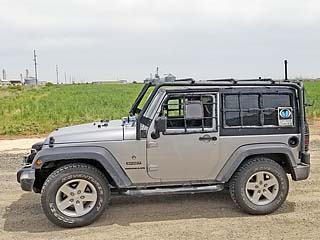
My vehicle (2016 Jeep Wrangler) on May 17, 2019 waiting for arrival of upper level wave and cap erosion near Grant, Nebraska. |
|
The sky becomes obvious of impending severe weather as the high altitude wave and upper level support for severe weather arrives over the Nebraska Panhandle during the afternoon of May 17. |
|
One of a few initial supercells that fired near the "triple-point" over the SW Nebraska region on May 17. This storm looked impressive but it became clear it was not the main storm of the day as it weakened afterwards as it pushed northwards past I-80. A cell moving from NW Kansas to SW Nebraska near McCook was to be the main storm of the day! |
|
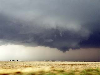
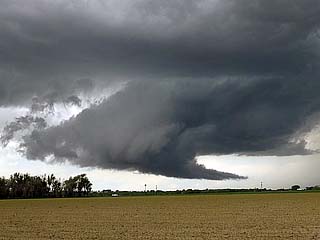
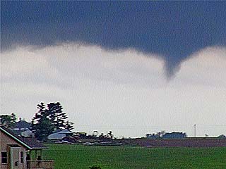
After playing catch-up and a long drive away from North Platte down Highway 83 to near Curtis, Nebraska, the main supercell is penetrated via "hook slicing" to get ahead of it. The view here, looking south and southeast towards Stockville, shows the impressive rain free base, and funnel cloud as the storm is about to cycle up again. This was around 6:30 PM CDT on May 17. |
|
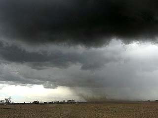
The storm intensifies and produces another funnel and subsequent tornado-genesis near Stockville, Nebraska at about 6:45 PM CDT on May 17. |
|
Ground circulation and dust / debris cloud confirms a tornado near Stockville and southwest of Farnam, Nebraska near 7 PM CDT on May 17. |
|
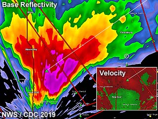
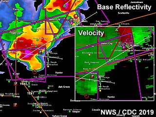
This is an image showing the impressive supercell storm and hook echo on the base reflectivity as it was northeast of McCook, Nebraska and approaching Farnam on May 17. The inset is the Doppler Velocity. The radar site is from North Platte and may not reflect the low level details of the storm as the beam was transecting the storm at or above 10,000 feet MSL. |
|
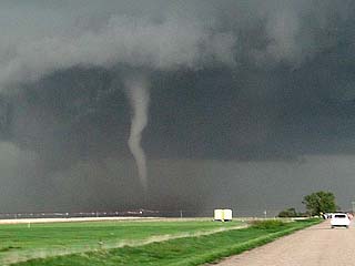
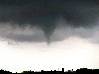
Large multi-vortex and dusty tornado, confirmed by expansive dust under rapidly rotating wall cloud, to the southwest of Farnam, Nebraska at about 7:15 PM CDT on May 17. |
|
Beautiful elephant trunk tornado as of 7:30 PM to the southwest of Farnam, Nebraska on May 17. Image is slightly enhanced to reveal the details. |
|
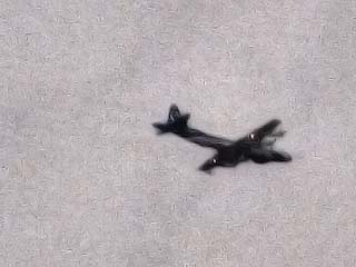
Hurricane Hunters WP-3 "Orion" aircraft circling overhead and east of the tornadic supercell on May 17 near Farnam. This is a research project known as TORUS (Targeted Observations by Radars and UAS of Supercells) going on in 2019. |
|
Close up view of the elephant trunk / stovepipe tornado southwest of Farnam, Nebraska on May 17. |
|
View of the tornado southwest of Farnam, Nebraska just prior to it roping out around and after 7:30 PM CDT on May 17. |
|
Tornado becomes rain-wrapped as the supercell cycles up again and passes just east of Farnam, Nebraska after 7:30 PM CDT on May 17. Powerful RFD winds are downing trees in this picture, with the tornado barely visible to the right. |
|
This is a view looking east of Farnam, Nebraska with the tornado lifting to the left, and the road way up ahead blocked by powerlines. Note the powerful RFD clear slot and dust being kicked up below it! This was about 7:45 PM CDT on May 17. |
|
View of another possible tornado around 8 PM CDT on May 17 as the storm passes by Cozad, Nebraska. Contrast is poor as the storm is becoming more HP and evolving to a line segment. |
|
View of forward-flank funnel as the tornadic storm passes north and east of Cozad, Nebraska late in the day on May 17. This is a possible anticyclonic tornado. |
|
View of embedded mesocyclone as storms become line segments / bows after dusk on May 17 to the west of Eddyville, Nebraska. |
|
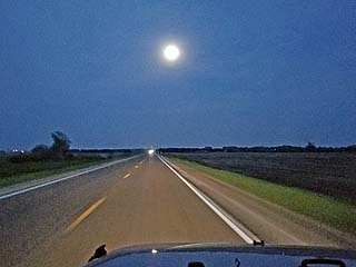
View of moon after wrapping up the chase and driving to Kearney, Nebraska for the night of May 17. |
|
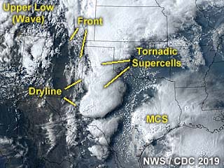
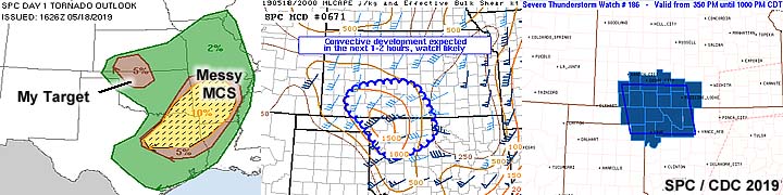
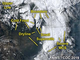
This is an annotated visible satellite image at roughly 23z showing the storms and environment unfolding over NW Oklahoma during air mass recovery at roughly 23z on May 18, 2019. Note the small supercell storms developing at the intersection of the dryline and stationary front. The MCS to the east was not of interest to storm chasing operations this day since it was over poor terrain with trees, as well as any tornadoes being embedded within the line of storms. |
|
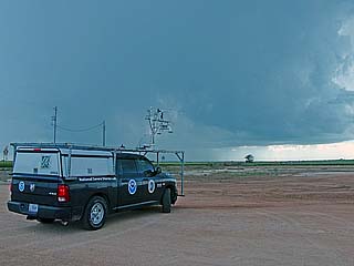
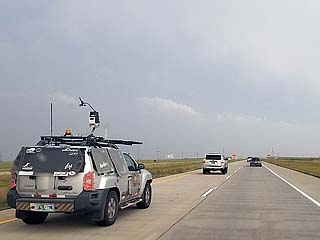
Storms initiating in the target area just west of Alva, Oklahoma as a National Severe Storms Lab (NSSL / TORUS) vehicle stands by in the foreground during the afternoon of May 18, 2019. |
|
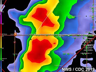
Radar base reflectivity of some small supercells developing near Alva, Oklahoma during the afternoon of May 18. In this image, a storm split is in progress. |
|
View of supercell base near Alva, Oklahoma during the afternoon of May 18. The view is to the west. |
|
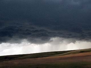
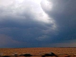
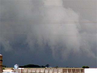
Supercell storm evolving to a line segment and becoming outflow dominant to the south of Alva, Oklahoma on May 18. The view is to the west and southwest. |
|
Amazing rock-hard cumulus and cumulonimbus surging into the sky to the southwest of Alva and on the southwest end of the bowing segment around sunset on May 18. |
|
This is a picture of the Pacific cold front moving into the area near the dryline during the evening of May 18 and southwest of Alva. |
|
May 19 was an off day and with a reposition back to Amarillo, Texas anticipating more storms for another active week. In this picture, at the Big Texan Steakhouse I am enjoying a great dinner with storm chasers. Here is Chris Kridler and Scott McPartland to name a few. |
|
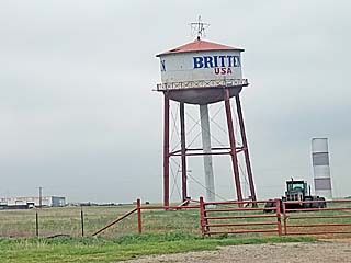
Passing by the so called "Leaning Tower of Texas" to the east of Amarillo on Highway 287 earlier on May 19. This old water tower tilted due to failed anchoring and leans to this day. |
|
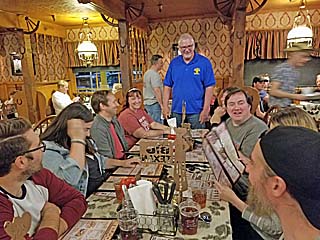
Our table at the Big Texan Steakhouse during the late evening of May 19. Charles Edwards is in the blue shirt at the end, and many chasers including Bill Hark and Scott McPartland are sitting at the table. |
|
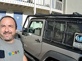
Myself enjoying the day off and preparing my vehicle for more activity starting right after May 19. |
|
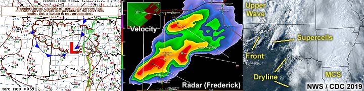
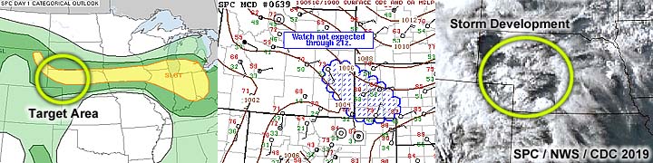
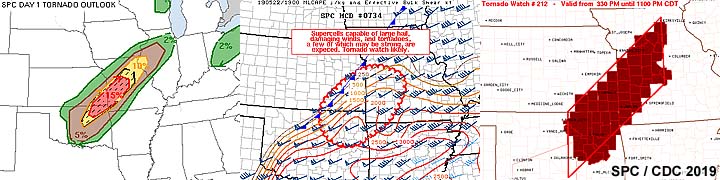
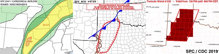
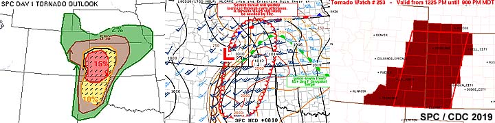
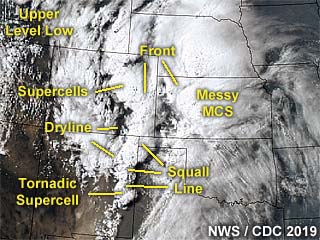
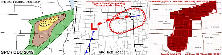
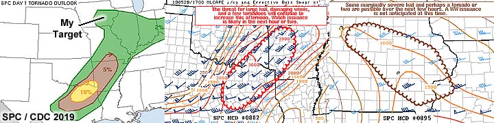
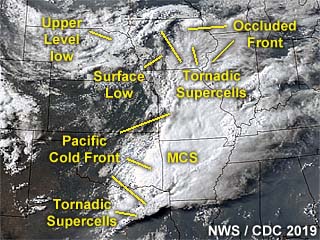
Annotated satellite image showing convective evolution and the synoptic setup during the afternoon of May 20, 2019. The linear nature of the dryline orientation (SW to NE instead of N to S) averted stronger tornadoes from forming on this day. |
|
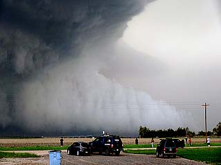
Group of storm chasers (one of many such groups) on the side of the road west of Hollis, Oklahoma in Texas near Highway 62 on May 20, waiting for convective initiation. |
|
Radar image (base reflectivity) of a tornadic supercell developing near Paducah, Texas during the early afternoon of May 20. The inset shows the Doppler velocity of the developing tornado. |
|
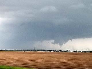
Tornado touches down near Paducah, Texas during the early to mid afternoon of May 20. The view is to the WSW. |
|
Thin rope stage of the Paducah, Texas tornado on May 20. The view is to the W. |
|
Close up view of the tornado near Paducah, Texas on May 20 showing the thin and hollow structure of the vortex tube. |
|
Storm cycling and producing another large funnel, or even a brief tornado, west of Childress, Texas on May 20. The view is to the SSE. This same storm will eventually produce another series of tornadoes, including the one near Mangum, Oklahoma. |
|
View of the navigation software and tracking showing how difficult it was to find a way back across the Red River. The original supercell can be considered "lost" at this point! |
|
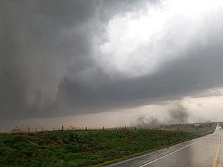
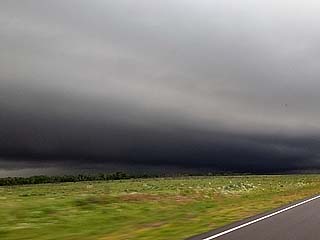
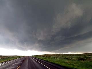
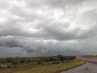
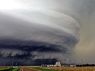
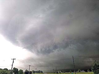
The storms near Hollis, Oklahoma later in the day became an active squall line and messy MCS (instead of the feared cluster of violent tornadic supercells). This shelf cloud and strong outflow denotes the chase day of May 20 is pretty much over. |
|
Annotated satellite image showing convective evolution and the synoptic setup during the afternoon of May 21, 2019. This is a cold-core setup with supercells developing in a cold-occlusion boundary. |
|
Initiation of strong and severe thunderstorms along the occluded front / confluence line east of the surface low over north-central Kansas on May 21. |
|
Base reflectivity radar image of a developing tornadic supercell near McPherson, Kansas during the afternoon of May 21. |
|
View of rain-free base of a developing tornadic supercell near McPherson, Kansas during the afternoon of May 21. |
|
Mild rotation of the developing supercell near McPherson, Kansas during the afternoon of May 21. |
|
Wall cloud of a supercell storm late in the day on May 21 north of Marquette, Kansas. |
|
Weakening supercell storm with funnel and RFD clear slot late in the day on May 21 north of Marquette, Kansas. |
|
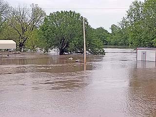
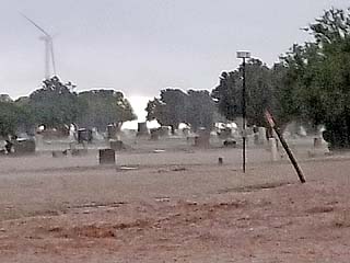
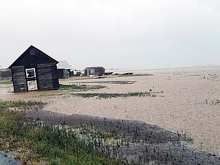
Severe flooding near the Arkansas River was encountered on the way to the target area on May 22, 2019. This is near Arkansas City, with swift flowing water inundating a field and farmstead. Flooding was a very serious issue during this period for many areas. |
|
Annotated satellite image showing convective evolution and the synoptic setup during the afternoon of May 22. Tornadic supercells are developing in NE Oklahoma and northeastward into SW Missouri. |
|
View of developing supercell anvil in an extremely unstable environment south of Tulsa, Oklahoma during the afternoon of May 22. This is the main target storm being approached, and the view is to the southwest. |
|
Radar image (base reflectivity) of the tornadic supercell developing northwest of Henryetta and near Okmulgee, Oklahoma during the afternoon of May 22. The inset shows the Doppler velocity of the tornado region of the supercell storm. |
|
View of the base of the soon-to-be tornadic supercell southwest of near Okmulgee, and near Wilson, Oklahoma during the afternoon of May 22. Note the wall cloud and funnel developing. The view is to the west. |
|
View of the wall cloud prior to tornado-genesis near Wilson, Oklahoma on May 22. The view is to the west. |
|
Developing tornado west of Wilson, Oklahoma on May 22. |
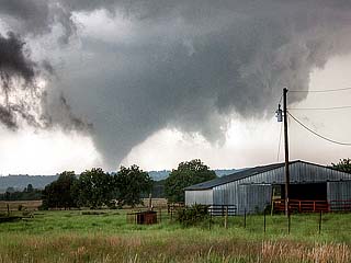
|
View of strong tornado to the west of Wilson, Oklahoma and southwest of Okmulgee during the afternoon of May 22. Fortunately this large tornado remained over open / rural areas. |
|
Tornado now west of Okmulgee, Oklahoma begins to lift and weaken as the supercell occludes late on May 22. |
|
View of the wall cloud of another supercell farther north near Chouteau, Oklahoma near dusk on May 22. |
|
View of a funnel west of Chouteau, and towards Pryor, Oklahoma after dark on May 22. The view is to the northwest. |
|
View of a funnel and possible tornado as the storm occludes near Pryor, Oklahoma after dark on May 22. The view is to the southeast. |
|
Annotated satellite image showing convective evolution and the synoptic setup during the afternoon of May 23, 2019. The complicated evolution is depicted here, with a linear MCS developing withing the storm environment, which unexpectedly produced a significant tornado to the northeast. More supercells are developing south near Lubbock, Texas. |
|
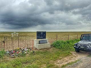
Visiting the "Samaras Memorial" near El Reno, Oklahoma during the morning of May 23 before heading west to the Texas Panhandle. Three storm chasers / scientists: Tim and his Son, Paul Samaras, and Carl Young - Perished in a large and deadly tornado on May 31, 2013 nearby this monument. |
|
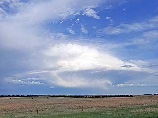
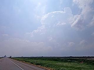
View of developing towering cumulus and cumulonimbus clouds to the west of Pampa, Texas during the afternoon on May 23. |
|
Base of a cluster / line of strong to severe storms west of Pampa, Texas during the afternoon of May 23. These were highly outflow dominant at this time (with cold outflow), however, part of this line segment will go on to produce a wedge tornado near Canadian later on. |
|
Storm chasers racing south on I-27 towards isolated supercells north of Lubbock, Texas late in the day on May 23. Many chasers abandoned the northern storms that were outflow dominant for the southern storms. |
|
Radar image (base reflectivity) of the supercell storms near Lubbock, Texas on May 23. The Doppler velocity image is in the inset, showing the broad rotation of the storm. |
|
View of rotating area and funnel cloud associated with a supercell storm east of Lubbock, Texas and near Idalou late in the afternoon of May 23 near sunset. |
|
Storm occluding with RFD clear slot late in the day on May 23. |
|
Eerie hail fog near Petersburg, Texas after dark with large hail laying in the road just behind the supercells northeast of Lubbock on May 23. |
|
Annotated satellite image showing convective evolution and the synoptic setup during the afternoon of May 24, 2019. It is apparent that this was to be more of a flooding event than tornadoes, with storms developing early in the day and becoming widespread by mid afternoon. |
|
Initial supercell storm with a small wall cloud developing in the early afternoon just south of Lubbock, Texas on May 24. |
|
Rotating wall cloud with RFD slot of a supercell evolving to an MCS / bow as it becomes outflow dominant east of Lubbock, Texas during the early afternoon of May 24. |
|
Radar image (base reflectivity) of a supercell storm near Cap Rock, Texas on May 24. The Doppler velocity image is in the inset, showing the broad rotation of the storm, just before merging with a cluster of storms. |
|
Wall cloud and supercell structure of a short-lived supercell storm west of Cap Rock, Texas before being undercut by surging outflow from storms to the NW on May 24. |
|
Chaser convergence on the side of the road south of Crosbyton, Texas in Hale County on May 24. |
|
Dave Lewison and Scott McPartland south of Crosbyton, Texas on May 24. |
|
Chris Kridler and her chase partner south of Crosbyton, Texas on May 24. |
|
Rushing water over a cemetery in Hale County (west of Crosbyton), Texas late in the day on May 24. |
|
Extreme flooding in the Texas Panhandle north of Crosbyton after many thunderstorms "trained" over the same area within a large MCS of strong and severe storms. Many fields were noticed underwater with water rushing across roadways late in the day on May 24. |
|
Severe flooding of a farmstead in Hale County, Texas late in the day on May 24. Scenes like this went on for many miles with roads barely passable. |
|
View looking west towards the dryline north of Plainview, Texas late in the day on May 24. |
|
View looking southward along the dryline / cold front intersection from north of Plainview, Texas late in the day on May 24. |
|
Annotated satellite image showing convective evolution and the synoptic setup during the afternoon of May 25, 2019. The biggest supercells developed only on the edges of a highly overturned boundary layer, including two that were southeast of the expansive MCS / MCC complex of storms. |
|
One of many storms that rapidly developed early in the afternoon of May 25. This messy storm complex is south and west of Canadian, Texas. |
|
Supercell storm base reflectivity image near Hall County, Texas during the early evening of May 25. The inset shows the Doppler velocity of this highly rain-wrapped mesocyclone. |
|
View of highly rain-wrapped region of the Hall County, Texas supercell near Brice on May 25. This is possible a rain wrapped tornado, with just a violent wind shift (70+ MPH) occurring with a cloud base visible in heavy rains and hail. Unfortunately, this system continued into Oklahoma and caused damage and fatalities after midnight in El Reno. |
|
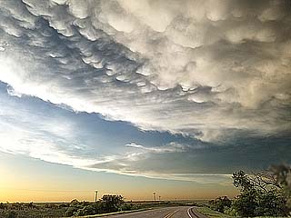
Mammatus clouds on the back side of the storm complex late in the day of May 25 over the Texas Panhandle. |
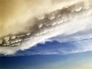
|
Closer view of the mammatus clouds near sunset on May 25 over the Texas Panhandle. |
|
Annotated satellite image showing convective evolution and the synoptic setup during the afternoon of May 26, 2019. Once again, in lieu of the past 3 days now, storms are firing too early in the day and quickly becoming widespread, destructively interfering with one another. The only viable tornadic storm that produced a large photogenic tornado was near Dora, New Mexico (and not even in any SPC tornado outlook area)! |
|
Short lived but intense supercell storm near Springfield, Colorado during the early afternoon of May 26. |
|
This is a base reflectivity image of a supercell north of Lamar, Colorado during the afternoon of May 26. The inset shows the Doppler velocity of the storm. This produced a very brief and weak tornado near Wiley. |
|
Approaching a tornadic supercell storm near Lamar and Wiley, Colorado during the afternoon of May 26. |
|
Wall cloud / rotating area of the supercell storm north of Lamar, Colorado during the afternoon of May 26. |

|
Reed Timmer and his "dominator 3" chase vehicle during a large chaser convergence north of Lamar, Colorado late in the day on May 26. |
|
View of intense rotation of the supercell storm as it formed near Lamar and is moving northeast near Cheyenne Wells, Colorado late in the day on May 26 and looking east. This was very close to producing a tornado, but failed due to more stable air to the east of the storm. |
|
View looking west at an occluded supercell / line segment near Sharon Springs, Kansas late in the day of May 26. A brief rain wrapped tornado was reported inside this complex of storms at the time. |
|
Looking westward from west of Goodland, Kansas at an approaching MCS of strong and severe storms during the early evening of May 26. An eerie green tint to the sky looms over I-70 as hail present in the storm core filters out green light late in the day. |
|
Annotated satellite image showing convective evolution and the synoptic setup during the afternoon of May 27, 2019. The supercell storms of interest are in an area anywhere from Fort Morgan, Colorado, and eastward through Holyoke and near Imperial, Nebraska late in the period. |
|
Heading west on Highway 34 as storms initiate to the southwest of Fort Morgan, Colorado during the afternoon of May 27. This is a caravan consisting of members of the TORUS research group. |
|
Wall cloud forming on a supercell storm near Brush and Fort Morgan, Colorado during the afternoon of May 27. |
|
A weak tornado passes to my south at close range under the rotating wall cloud north of Brush, Colorado during the afternoon of May 27. |
|
Another weak tornado being pushed ahead of the parent mesocyclone as the supercell becomes outflow dominant north of Brush, Colorado during the afternoon of May 27. |
|
With the storms near Fort Morgan becoming linear and outflow, the new target area is near Yuma, Colorado. Here a developing storm complex, albeit low topped and high based, can be seen looking southeast. This will evolve into an incredible supercell storm as it moves east over NE Colorado and eventually into Nebraska later on May 27. |
|
The Yuma, Colorado supercell starts out as an LP storm with a high base, then becomes more classic with the arrival of upper level support and up-slope moisture influx during the afternoon of May 27. |
|
A brief tornado (dust swirl barely visible left of the road and pole) forms between Yuma and Holyoke, Colorado with an impressive wall cloud / funnel late in the afternoon of May 27. |
|
The supercell grows and becomes classic to HP mode as it nears the CO / NE border south of Holyoke, Colorado. A developing tornado can also be seen in the "notch" of this storm. This is during the early evening of May 27. The view is to the southwest. |
|
Base reflectivity image of the main and powerful supercell moving out of northeast Colorado during the afternoon of May 27, and near Imperial, Nebraska. The inset shows the Doppler velocity of the storm, which was producing tornadoes and sporting a striking visual appearance at the time. |
|
View of HP supercell as it was moving out of NE Colorado late in the day of May 27 east of Holyoke. The multi-vortex tornado can be seen just left of the roadway. |
|
Small weather balloon and probe rising rapidly into the supercell updraft after release by members of the TORUS group late on May 27 and west of Imperial, Nebraska. |
|
Suction vortex in the HP notch / multi-vortex tornado briefly visible west of Imperial, Nebraska on May 27. The view is to the west. |
|
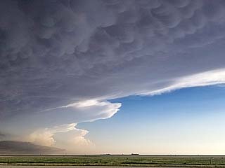
Absolutely "jaw dropping" structure of the HP tornadic supercell storm near Imperial, Nebraska late in the day on May 27. Note the green "hail" color to the upper right with "stacked plates" structure, as well as a large tornado possibly on going just behind the tanks in the foreground. |
|
Another brief view into the supercell notch reveling a multi-vortex tornado west of Imperial, Nebraska on May 27. The view is to the northwest. |
|
Incredible stream-wise vorticity current screaming into the northeast side of the supercell storm from right to left looking northwest of Imperial, Nebraska on May 27. |
|
Another incredible view of the HP supercell to the northwest of Imperial, Nebraska on May 27 near SR 61. The view is to the northwest. Note the "beavers tail" extending above the stream-wise vorticity current from left to right in the lower portion of the photo. |
|
View of an area of intense rotation from within the RFD of the supercell looking north of Imperial, Nebraska along SR 61 late on May 27. This was a multi-vortex tornado and had brief suction spots observed by many chasers, even the TORUS research group. Winds here were gusting out of the west near 80 MPH in RFD. |
|
Annotated satellite image showing convective evolution and the synoptic setup during the afternoon of May 28, 2019. Tornadic supercells have formed to the southwest of Kansas City (with a destructive rain-wrapped tornado near Lawrence) as well as farther west in north-central, Kansas - Which produced highly photogenic and visible tornadoes near Tipton. |
|
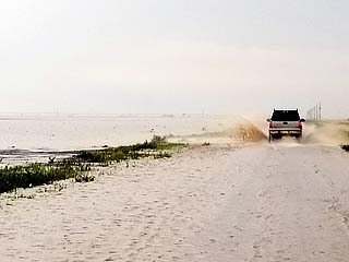
Severe flooding and a closed road (Jeep Road) south of Enterprise, Kansas during the afternoon of May 28. There are submerged railroad tracks there too. |
|
Base reflectivity image of the Kansas City / Lawrence, Kansas supercell during the afternoon of May 28. Note the prominent "swirl" in the reflectivity, denoting a highly rain-wrapped HP supercell tornado. To the right are two insets, with the distinct correlation-coefficient showing debris (blue) to the top, as well as extreme Doppler velocities on the bottom inset. |
|
Distant view of the supercell storm that will become the destructive Kansas City / Lawrence tornado while trying to decide to go east or not during the afternoon of May 28. The storm here is 40 to 50 miles away and the view is to the east and southeast. |
|
Base reflectivity image of Tipton / Beloit, Kansas supercell during the afternoon of May 28. The inset shows the Doppler velocity of the storm. |
|
View about 40 miles from the Tipton / Beloit, Kansas tornadic supercell during the afternoon of May 28. I am rushing north and west to reach this storm. A large tornado was in progress when this photo was taken. The view is to the northwest. |
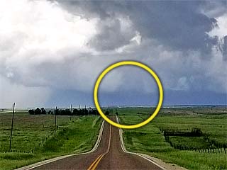
|
While approaching the Tipton / Beloit, Kansas supercell a "day late and a dollar short", a brief glimpse of the last tornado produced by that storm is barely visible in this picture (circled) from about 20 miles out. |
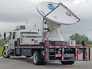
|
Doppler on wheels truck west of Clay Center, Kansas during the early evening of May 28. |
|
Small supercell storm with hail and rotation to the east of Clay Center, Kansas during the evening of May 28 before being undercut by the Pacific cold front / outflow. The view is to the east. |
|
Intense rotation, looking up, and close to producing a tornado, with a small supercell storm east of Clay Center, Kansas before being undercut by outflow on May 28. |
|
Annotated satellite image showing convective evolution and the synoptic setup during the afternoon of May 29, 2019. The main area chased was in eastern Iowa, owing to a cold-occlusion and "cold-core" environment east of a surface low. |
|
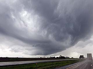
Convective initiation along a cold-occluded front / confluence line east of a surface low west of Iowa City and east of Des Moines, Iowa during the afternoon of May 29. The view is to the east along I-80. |
|
Small supercell storm developing along a cold occlusion west of Iowa City, Iowa during the late afternoon of May 29. The view is to the west and southwest from along I-80. |
|
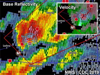
Doppler (base reflectivity) radar image of a tornadic supercell west of Iowa City and near Williamsburg, Iowa late in the day on May 29. The inset shows the intense Doppler velocity as well as my position in the blue cross-hair circle. |
|
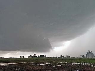
Developing supercell storm west of Iowa City and north of Williamsburg, Iowa during the late afternoon of May 29. The view is to the west with a large wall cloud and updraft-downdraft interface (UDI) to its right. |
|
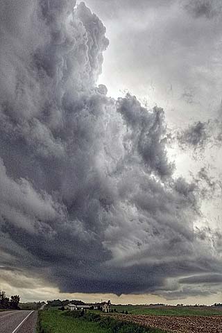
Small supercell storm and funnel near Williamsburg, Iowa late in the day on May 29. The view is to the SSW. |
|
View of funnel / developing tornado on a small supercell storm near Williamsburg, Iowa late in the day on May 29. The view is to the SSW. |
|
Another view of the funnel / developing tornado near Williamsburg, Iowa on May 29 a few minutes later. |
|
Close-up of funnel / tornado on near Williamsburg, Iowa on May 29 before the storm weakened. |
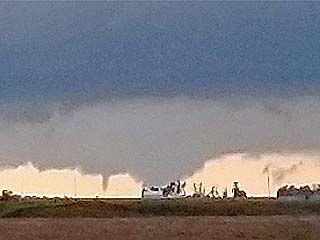
|
View looking west towards a possible large tornado and satellite funnel rotating around it west of Williamsburg, Iowa late on May 29. The view is to the west. |
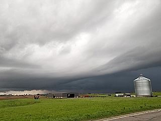
|
View of storm moving north of Williamsburg and west of Iowa City, Iowa late in the day on May 29. The view is to the NW and the storm is merging with another small supercell and evolving to a line / bow segment. |
|
May 30 was a travel day, with a drive from Iowa City to Chicago for down time. In this image, a small (non-severe) convective shower hangs over Aurora, IL during the early afternoon of May 30, 2019. |
|
View of the Chicago River in downtown Chicago during some down-time spent in that area on a foggy cool afternoon. |
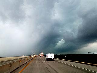
|
This is a strong to severe thunderstorm complex near Janesville, Wisconsin on June 1, 2019. This storm contained strong winds near 60 MPH and large hail (hail shaft is to the left in this picture). |
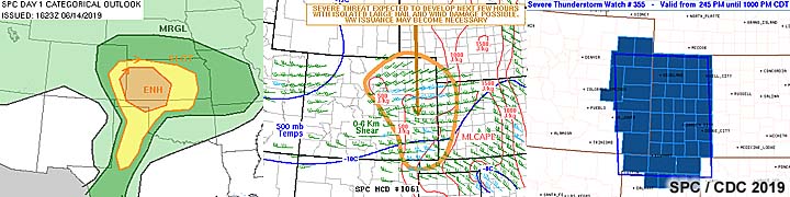
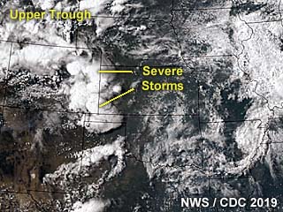
|
This is an annotated visible satellite image of the synoptic environment as of 23z on June 14, 2019. The marginal setup can be seen in southeastern Colorado where some supercell storms are developing and evolving to a line of thunderstorms. |
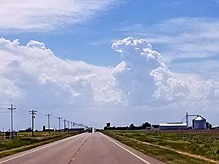
|
Strong and severe storms initiating west of the KS / CO border during the afternoon of June 14. |
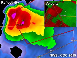
|
Base reflectivity radar image of a high-based supercell storm near the Colorado / Kansas border and northwest of Manter, Kansas on June 14. The upper-right inset shows the velocity associated with this supercell. |
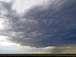
|
Maturing low-precipitation (LP) high-based supercell near the CO / KS border during the afternoon of June 14. |
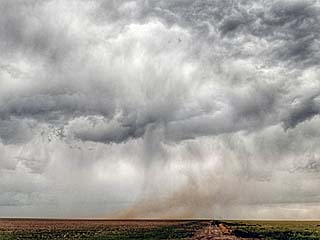
|
Funnel / mesocyclone of high-based supercell storm with RFD dust during the late afternoon of June 14 to the north of Manter, Kansas near the Colorado / Kansas border. |
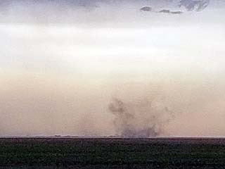
|
Gustnado along the high-based storm outflow near Manter, Kansas late in the afternoon of June 14. |
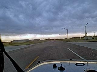
|
Strong outflow, or even a heat burst (temperatures go up in a dry downdraft) to the northeast of Manter, Kansas on June 14. |
|
This is an annotated visible satellite image of the synoptic environment as of 23z on June 15, 2019. The annotation points out very important features, such as a stationary frontal boundary over northern Oklahoma and a dryline / trough over the Texas Panhandle. The tornadic supercell storm I was on is also shown developing in this image. |
|
While waiting form storms to develop, I met up with Dan Shaw and a few other storm chasers in Wakita, Oklahoma and visited the Twister Museum during the afternoon of June 15. I am standing in front of one of the faux "tornado probes" called "Dorothy" used in the movie from 1996. |
|
Another view of the Twister Museum in Wakita, Oklahoma during the afternoon of June 15. Note the tornado shelter and "Bill Paxton" memorial as portrayed on Spotter Network. |
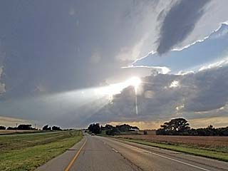
|
Storms initiate and quickly become severe in NW to Central Oklahoma during the late afternoon of June 15. |
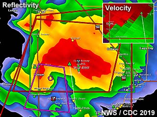
|
Base reflectivity radar image of a powerful tornadic HP supercell storm 25 miles north of Clinton, Oklahoma near Putnam and in Custer County near dark on June 15. This storm produced a large tornado at the time, and the impressive Doppler velocity of the storm is shown in the upper-right inset. |
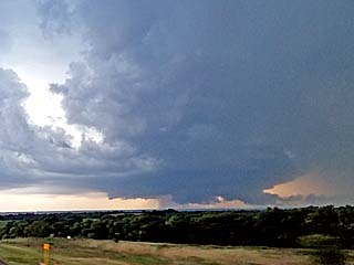
|
First view of the "tail-end" supercell to the north of Putnam, Oklahoma late on June 15. This is the "classic" mode of this storm before evolving to HP (high precipitation) mode and is already tornado-warned at this time. |
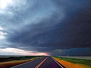
|
Striated view of updraft and RFD region of the Custer County, OK supercell near dusk on June 15. |
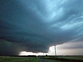
|
View looking north at the main updraft and HP storm mesocyclone after dusk on June 15 in Custer County, OK. |
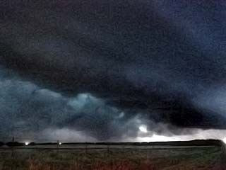
|
Large truncated wedge / cone tornado illuminated by lightning appears in the lower left of this picture taken west of Custer City, Oklahoma after dark on June 15. The view is to the northwest towards Putnam. |
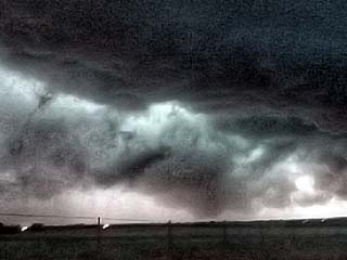
|
Another view (lightning illuminated) of the tornado west of Custer City, Oklahoma after dark on June 15. |
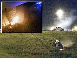
|
A nearly deadly accident occurred at the intersection of Highway 183 and I-40 in Clinton, Oklahoma with a mangled vehicle on fire with the tornadic storm grazing the area to the north. EMS and myself managed to drag the woman and her two children out of the vehicle before fire consumed it. |
|
Extremely heavy rains and winds gusting near 90 MPH impacts Clinton, Oklahoma during the evening of June 15 as the powerful MCS catches up with the tornadic HP storm to the north. |
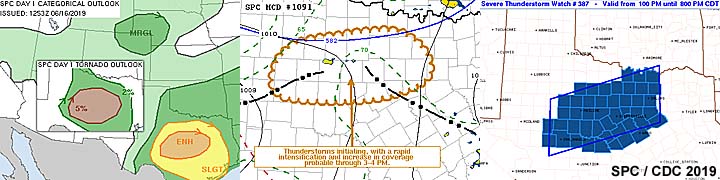
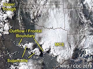
|
This is an annotated visible satellite image of the synoptic environment as of 23z on June 16, 2019. The area chased is also indicated in central Texas with isolated supercell storms developing there along a boundary. |
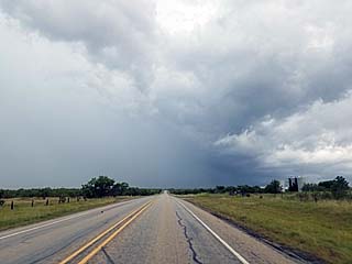
|
Passing through a severe cluster of late morning / early afternoon storms on June 16 near Albany, Texas. The storms contained hail to golfball sized. The hail shaft is visible to the left. |
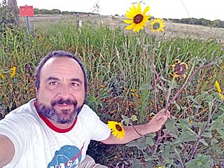
|
Picture of myself in a field of wild flowers while waiting for late afternoon storms to organized on June 16. |
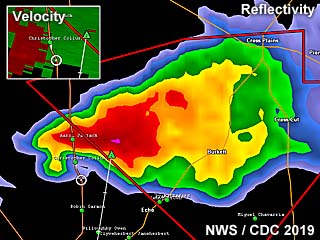
|
Base reflectivity image of a classic / LP supercell storm northwest of Santa Anna (over Callahan County), Texas during the afternoon of June 16. Note the small "hook" in the reflectivity. The upper-left inset shows the Doppler velocity of the storm. My GPS location is the white circle. |
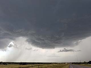
|
Intensifying low-precipitation / classic supercell northwest of Santa Anna (over Callahan County), Texas during the afternoon of June 16. |
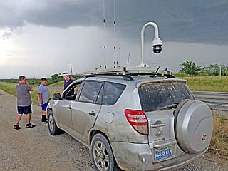
|
Dan Shaw and a few other chasers meeting "under the mesocyclone" during the afternoon of June 16 in Callahan County, Texas. |
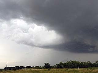
|
RFD clear slot of the Callahan County LP supercell storm on June 16. |
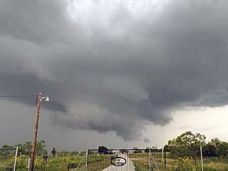
|
The LP supercell and it's RFD produces this nice low wall cloud before weakening to the northwest of Santa Anna, Texas on June 16. |
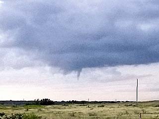
|
A funnel cloud develops on the updraft on the SW portion of the LP supercell storm down-scaling to the northwest of Santa Anna, Texas on June 16. |
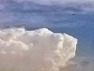
|
Here is a view of the WP-3 "Orion" aircraft (for the TORUS research project) flying overhead as the storm weakens with another distant supercell to the south as the back-drop as of late afternoon on June 16. |
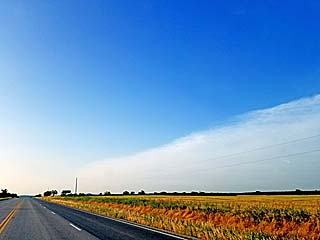
|
The shortwave trough moves by and the clear "dry punch" of air ends the day on June 16 by early evening. |
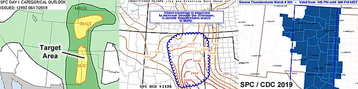
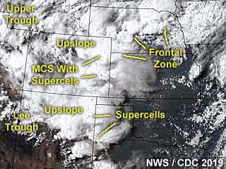
|
This is a visible satellite image of the synoptic environment as of 23z on June 17, 2019. The annotation points out important features of this rather complex setup. The main focus is up-slope wind flow in far western Texas. |
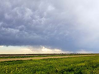
|
Approaching an LP (low precipitation) supercell with mammatus and anvil blow-off overhead in the western Texas Panhandle during the afternoon of June 17. The developing LP storm base is to the lower right in this view towards the southwest. |
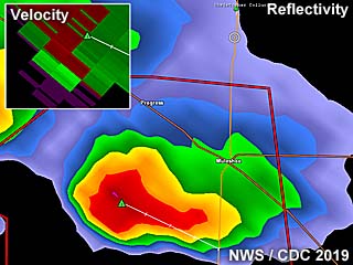
|
Base reflectivity image of an LP supercell storm near Muleshow (over Bailey County), Texas during the afternoon of June 17. The storm was high based and produced mainly hail. Weak velocity appears in the inset to the upper-left. |
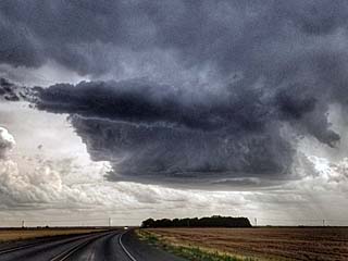
|
Low precipitation supercell storm near Muleshow, Texas during the afternoon of June 17 as it was producing large hail to at least 1.5". |
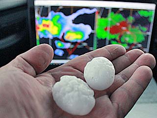
|
Hail stones from the LP storm near Muleshow, Texas during the afternoon of June 17. |
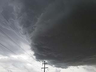
|
Closeup view of updraft base of the LP supercell storm on June 17 near Muleshow, Texas. |
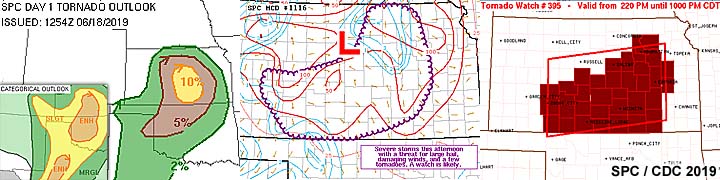
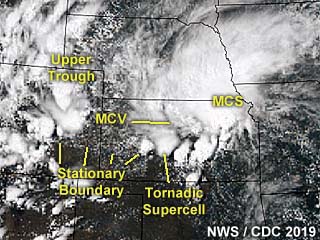
|
This is a visible satellite image of the synoptic environment as of 22z on June 18, 2019. Important features are annotated with a mesoscale convective vortex crossing Kansas and a surface boundary providing the stream-wise vorticity for a tornadic supercell storm. |
|
Passing into Kansas north of Clearwater and the clouds associated with an MCV (mesoscale convective vortex) and surface boundary can be seen looming over the horizon. |
|
Meeting up with Dan Shaw (center on the phone) and Greg Ansel (left) with several other chasers for a quick fuel stop in Greensburg, Kansas and grabbing a quick subway sandwich to go as a nice storm was already developing to our northwest and becoming severe warned. Greg Ansel is also holding a storm "probe" of some sort he found with a parachute attached (maybe Reed Timmer's)? |
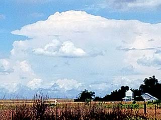
|
The chase is on! In the distance, a developing supercell can be seen looking northwest of Greensburg, Kansas on June 18. This storm will quickly become severe and produce some brief tornadoes later near Kinsley. |
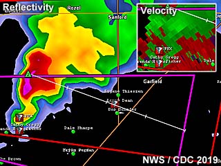
|
Base reflectivity radar image of a tornadic supercell storm over Hodgeman and Edwards Counties, Kansas during the afternoon of June 18. The classic supercell signature is shown, with the velocity to the upper-right. Storm spotter network icons also appear on this image. |
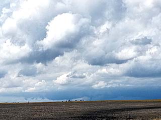
|
Approaching a tornadic supercell (about 10 to 15 miles away) near Kinsley, Kansas during the afternoon of June 18. The view is towards the northwest and a tornado is visible on the ground just to the right of the lower-center of the picture. |
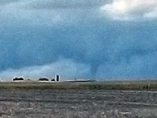
|
Closer view of a brief tornado on the ground (from a distance of 5 to 10 miles) while closing in on a classic supercell storm near Kinsley, Kansas during the afternoon of June 18. |
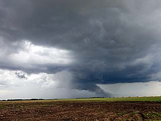
|
View of wall cloud as the storm moves north of Kinsley, Kansas on June 18. The view is to the north. |
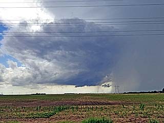
|
View of formerly tornadic supercell storm east of Kinsley, Kansas on June 18. Looking west, the wall cloud and updraft structure can be seen. |
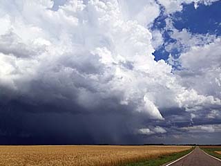
|
Another supercell storm developed west of Wichita, but evolved to an MCS and became quickly undercut by outflow late in the day on June 18. The view here is to the east and northeast. |
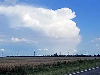
|
A distant supercell storm can be seen looming in the distance while headed south back into Oklahoma during the early evening of June 18. This storm later became tornado warned west of Tulsa, Oklahoma. The view is to the southeast. |
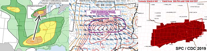
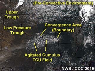
|
This is a visible satellite image of the pre-convective environment near the target area during the 18z time frame on June 19, 2019. The annotated image shows the synoptic features of the setup, with a developing field of agitated / towering cumulus along a convergence area / boundary in north-central to NE Texas. |
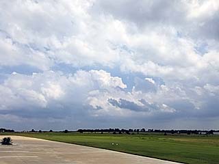
|
Convective initiation over north-central to northeastern Texas late in the day on June 19 as the cap is breached by surface heating. |
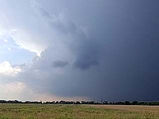
|
A developing supercell storm becomes established west of Greenville, Texas. The view is to the west and the main updraft base is in the center of the photo. |
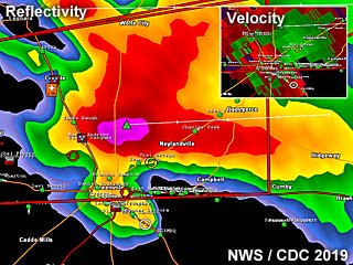
|
Base reflectivity radar image of a tornadic HP supercell storm as it neared Greenville, Texas late in the day on June 19. The storm has a prominent "hook echo" forming on its SE side and a velocity couplet in the upper-right inset. |
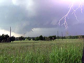
|
Intense lightning and rotating wall cloud as the storm intensifies and begins rotating west of Greenville, Texas on June 19. |
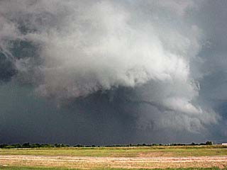
|
View of a funnel cloud on a rotating wall cloud to the west of Greenville, Texas during the afternoon of June 19. |
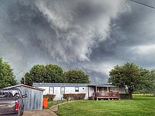
|
A rotating wall cloud / funnel can be seen here as it passes menacingly close to a trailer home west of Greenville, Texas during the afternoon of June 19. |
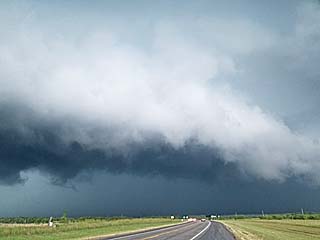
|
View of FFD (forward flank downdraft) to the northwest of Greenville, Texas during the afternoon of June 19. The storm is beginning a right turn and starting to move to the SE, with a forward-flank mesocyclone forming. High-end EF-1 tornado damage was reported in Greenville. |
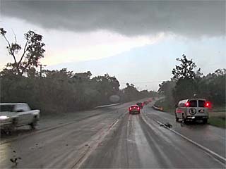
|
View of flying tree debris and strong winds associated with the eastern side of a possible rain-wrapped tornado while racing southeast out of Greenville, Texas during the afternoon of June 19. The view is to the southeast. Note the chase tour van stopped to the right. Winds are gusting over 70 MPH here. |
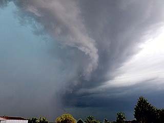
|
View looking north at the rain-wrapped circulation (any tornado would be to the far-left in this picture behind the "wet" RFD). This was southeast of Greenville, Texas during on June 19. |
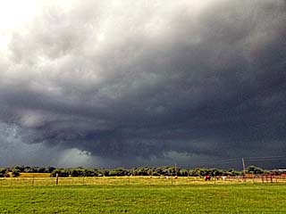
|
Looking back west into the "notch" of the HP supercell where a large wall cloud can be seen. A brief view of a possible large rain-wrapped tornado was also spotted by Roger Hill's tour group from this location late on June 19. |
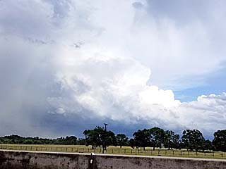
|
The storm continues to the southeast and weakens / evolves to an MCS via upscale growth. The view of the backside of the updraft can be seen late in the day on June 19. The view is to the southeast. |
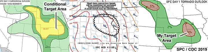
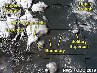
|
Annotated visible satellite from near 23z on June 20, 2019. The important features of the synoptic environment are denoted, such as boundaries and a solitary LP supercell storm over NE Kansas. |
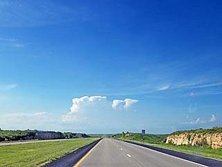
|
Initiation of a supercell storm north of Manhattan, Kansas late in the afternoon of June 20. This will develop into a beautiful LP (low precipitation) supercell storm near Nemaha County, Kansas. |
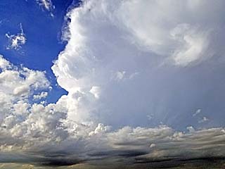
|
View of developing LP supercell storm near Nemaha County, Kansas on June 20. |
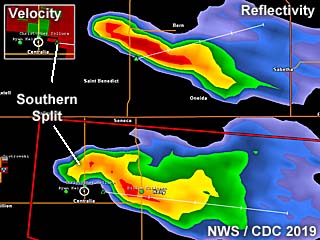
|
Annotated base reflectivity image of two supercell storms over NE Kansas on June 20 during the early evening. This originally was a single storm that split into two, with the most intense supercell being the southern storm. The velocity image is in the upper-left inset. If you look closely at the "left split" of the storm to the north, it has a slight anticyclonic "curl" in its reflectivity on the western end (clockwise)! |
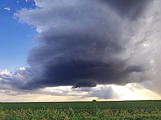
|
View of intensifying (and beautiful) LP supercell storm over Nemaha County, Kansas. Note the small wall cloud too! The view is to the west. |
|
While pulled over and watching the LP supercell to my west, this little furry animal (probably a farmer's dog from a nearby ranch) comes out of nowhere and joins me watching the storm! |
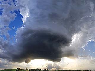
|
Wide-angle view of LP supercell storm over Nemaha County, Kansas. The view is to the west. |
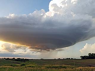
|
Low precipitation supercell storm over Nemaha County, Kansas during the early evening of June 20. The distant "left split" can be seen to the far lower right. |
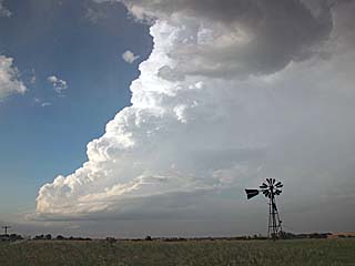
|
Closer view of the left-moving northern split of the LP supercell that is anticyclonic and moving away to the northeast late on June 20. Note the impressive bulk shear and tilting of the updraft. |
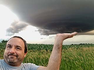
|
Who could resist? I just take a humorous selfie of myself as if I am holding up a stack of plates! This was as the LP supercell over Nemaha County, Kansas started weakening / down-scaling during the evening of June 20. |
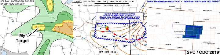
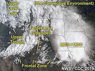
|
This is a visible satellite image of the pre-convective environment near the target area during the 18z time frame on June 21, 2019. The annotated image shows the synoptic features of the setup, with my area targeting the up-slope expected in Colorado. The large messy complex of storms (to the east / right in the image) is of no interest to storms chasing in this case. |
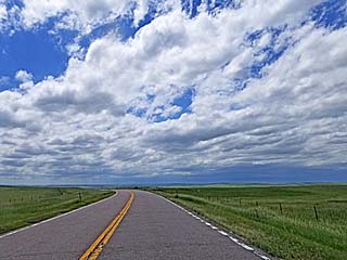
|
Storms begin initiating near the Palmer Divide in Colorado. This view is looking west from northwest of Limon, Colorado near Cedar Point off I-70 while targeting storms developing between Castle Rock and Kiowa, Colorado during the afternoon of June 21. |
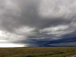
|
A large supercell storm can be seen with a low rotating base and shelf / wall cloud near Kiowa, Colorado on June 21. |
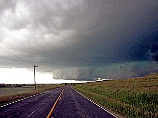
|
Wall cloud rotating on the southwestern supercell to the SW of Kiowa, Colorado on June 21. Note the impressive shelf cloud extending to the right with the rotating portion lowering to its left in the center of the picture. |
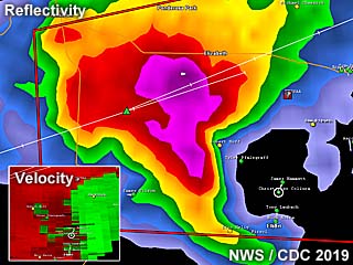
|
This is a base reflectivity image of a tornadic supercell storm developing over the Palmer Divide area near Kiowa, Colorado on June 21. The hook is prominent and the storm velocity image is the lower-left inset. A weak tornado was observed at this time (the white circle being my GPS location). |
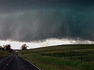
|
Close up of rotating wall cloud and brief tornado, denoted by dust on the ground, southwest of Kiowa, Colorado on June 21. |
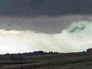
|
Another view of a brief tornado (dust under non-condensed rotation) southwest of Kiowa, Colorado on June 21. |
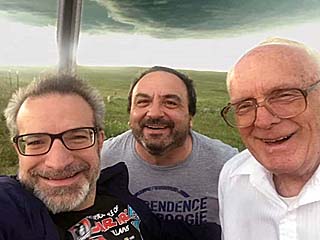
|
It was an awesome pleasure meeting up with Dr Jason Persoff, left, and veteran chaser Dave Hoadley, right, literally "under the meso" while headed back east to the northwest of Limon, Colorado late in the day on June 21. Thanks to Dave Hoadley for sharing this picture of myself (center) and us! Dave has been out chasing more (and longer) than any other storm chaser to this day. |
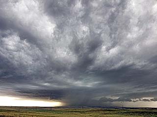
|
View of the supercell storm moving east and southeast towards Limon, Colorado on June 21 from the Cedar Point exit off I-70. The storm is now a major hail threat at this point. |
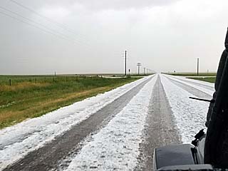
|
Hail covers the roadway just behind the weakening supercell storm to the southwest of Limon, Colorado on June 21. |
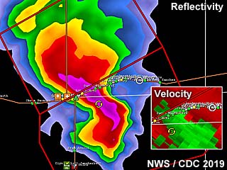
|
Base reflectivity image of an HP supercell evolving to a line segment / bow that will produce very large hail and 100 MPH wind gusts (note the RIJ / rear inflow jet!) as it crosses from NE Colorado and into Kansas on June 21. The lower-right inset shows the intense velocity of the storm as it "gusts out" and produced extreme damaging winds. |
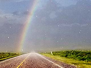
|
Beautiful view of an intense rainbow (or "hail-bow") while racing eastward past Kit Carson, Colorado with hail up to golfball sized falling in the foreground during the early evening of June 21. |
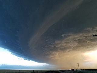
|
Powerful bow segment evolving from an HP supercell undergoing upscale growth and passing from NE Colorado into western Kansas during the evening of June 21. Rear inflow jet mentioned in the radar analysis can be seen visually looking south in this image (just above the power poles) kicking up dust. |
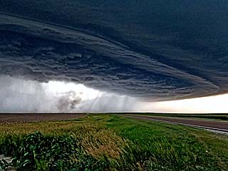
|
Developing intense progressive derecho (destructive straight-line winds) with an impressive shelf cloud / rotating head of the bow segment around dusk on June 21 just west of the KS / CO border. The view is to the northwest. |
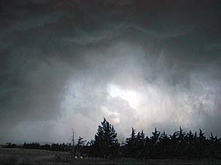
|
Rapidly approaching extreme / damaging (XDW) straight-line winds looking west from near Sharon Springs, Kansas at gas station after dusk on June 21. It does not look like much here, but winds gusting near or over 100 MPH are rapidly approaching from the west. |
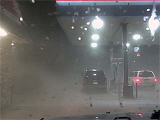
|
Dust, hail, and small rocks are kicked up in two powerful micro-bursts (the first being dry, and the second loaded with rocks and hail) at a gas station in Sharon Springs, Kansas after dusk on June 21. The second "derecho" surge of straight-line winds gusted near 100 MPH blowing out windows on many vehicles parked at the gas station. The rear window on my Jeep was blown out from the sand / rocks, with even the screen on my phone, mounted on the dash board, broken! Rocks and sand were all over my vehicle, and the front window was cracked and mirrors pitted. |
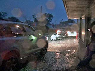
|
View of another chaser's vehicle with all the windows blown out. The storm has passed and is moving into Kansas leaving the power out, hail covering the ground, and damage in Sharon Springs after dark on June 21. Luckily no one was seriously hurt in this. |
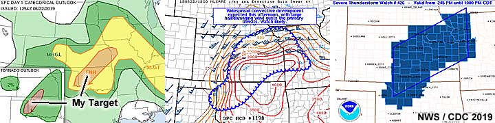
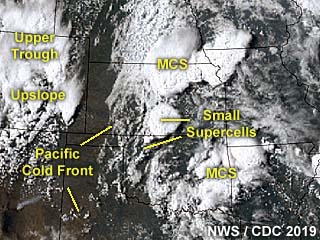
|
This is an annotated visible satellite image of storms developing late in the day on June 22, 2019 around 23z. This is a highly complex setup, and the image is annotated to point out important features such as boundaries and troughs. |
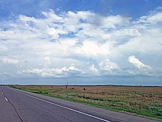
|
Storms initiating along a boundary / confluence axis looking southeast of Woodward, Oklahoma late in the afternoon on June 22. |
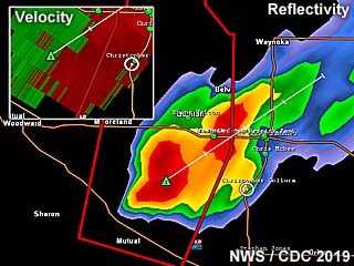
|
Base reflectivity radar image, and upper left inset showing velocity, of a small / transient supercell storm over Major County, Oklahoma late in the day on June 22. |
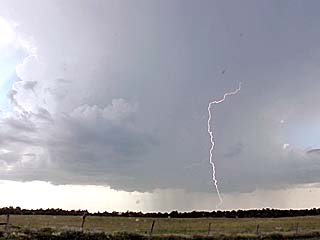
|
View of supercell structure (with CG lightning) within a cluster of severe storms developing over Major County, Oklahoma on June 22. |
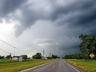
|
Brief slowly rotating funnel (left of the center of the picture) with a storm near Major County, Oklahoma on June 22. The view is to the north and northwest. |
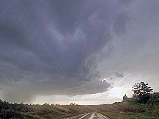
|
Left split and weakening phase of a small supercell storm near Major County, Oklahoma on June 22. The view is to the west. |
|
Would you try to drive on this so called "road" in the rain? I wouldn't, even with a Jeep unless a tornado was chasing me! |
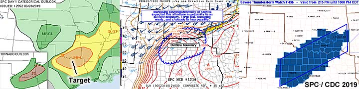
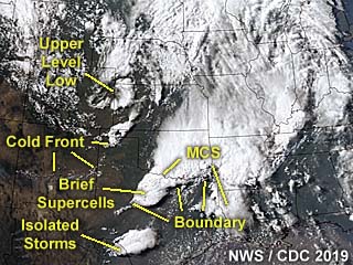
|
This is an annotated visible satellite image of storms developing late in the day on June 23, 2019. The annotation shows important features and the line of storms / brief supercells can be seen over north-central Texas as of 23z. |
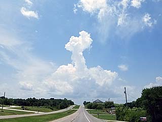
|
Cap erosion during the afternoon of June 23 over south-central Oklahoma / north-central Texas (near the Red River) and along an outflow boundary. A lone towering cumulus called called a "turkey tower" wells up above the weakening capping inversion. |
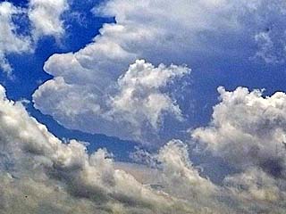
|
Storms developing during the afternoon on June 23 over south-central Oklahoma / north-central Texas. Unfortunately, these storms will quickly become a multicell cluster / line of storms, and get undercut by outflow. |
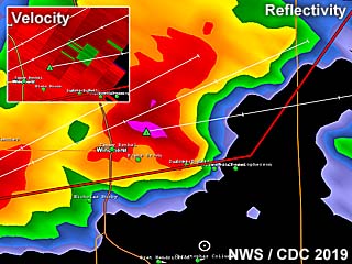
|
Base reflectivity radar image of strong and severe storms in a line / cluster over north-central Texas and near Clay County on June 23. The upper-left inset shows an area of rotation within the cluster of storms (embedded HP supercell). |
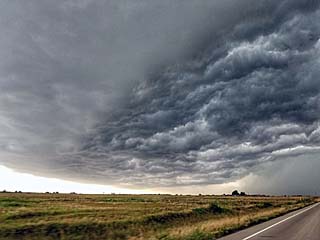
|
A shelf cloud and "whales mouth" formation on it's backside as an outflow dominant severe storm complex is approached in Clay County, Texas on June 23. |
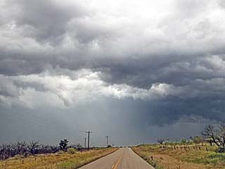
|
View of an area of rotation (note high based wall cloud and RFD clear slot) within the cluster of severe storms in north-central Texas late in the day on June 23. |
|
Looking back at mammatus clouds looming over the western sky in north-central Texas near dusk on June 23. |
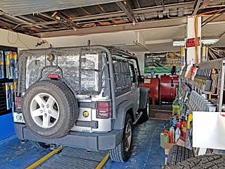
|
June 24 was a travel / off day. Here I am getting my vehicle done for routine maintenance in Oklahoma City before heading north to Kansas City later in the day. |
|
View of Oklahoma City while traveling to the Kansas City area on June 24. The Devon Energy Building is to the left and is the highest sky-scraper in the central USA west of the Mississippi River. |
|
This is my driver's side mirror with the hail grill removed. It appears dirty with dark dust spots on it. Unfortunately these are pit marks from the June 21 storm (near Sharon Springs, Kansas) peppering it with rocks and sand, and the mirror needs to eventually be replaced. |

|
Many people think Kansas City is the capitol of Kansas. It is not, and plus Kansas City is in Missouri as well with Jefferson City as its capitol. In this picture, the Kansas capitol building of Topeka is shown, which is west of Kansas City, while driving by on June 24 / 25. |
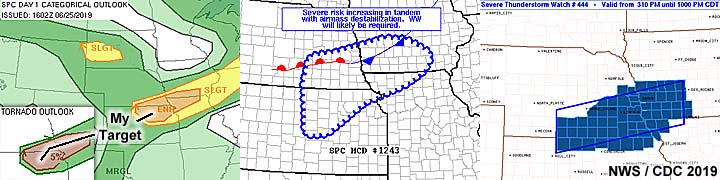
|
This is a visible satellite image of the storms developing on June 25, 2019 at roughly 23z. The annotated image shows supercell storms firing along an east to west oriented boundary north of the KS / NE border. |
|
Convective initiation looking west over south-central Nebraska as a surface front / boundary is approached during the afternoon of June 25. |
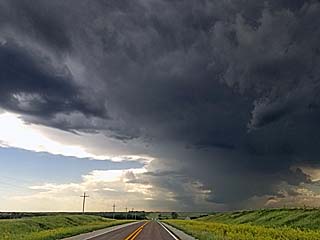
|
Approaching some supercell storms near Davenport, Nebraska during the afternoon on June 25. A low precipitation (LP) storm is to the east (in the foreground to the lower right) with a larger high precipitation (HP) storm forming to the west near the dryline / front triple-point. The view is to the west. |
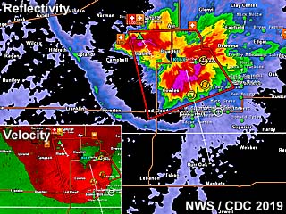
|
Radar (base reflectivity) image of an HP supercell storm developing near Nuckolls and Thayer Counties in Nebraska late in the day on June 25. Note where the outflow boundaries intersect at the dryline / frontal zone "triple point" which is visible by the blue softer reflectivities. The inset image to the lower left is the velocity of the storm, showing its highly outflow dominant nature. |
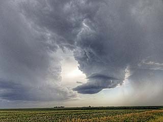
|
An LP supercell down-scaling after a storm split near Davenport, Nebraska during the afternoon on June 25. |
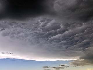
|
Anvil blow-off and mammatus from the storm complex over south-central Nebraska during the afternoon of June 25. |
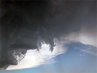
|
Small mid-high level shear funnel and rotation area on the weakening LP supercell near Davenport, Nebraska during the afternoon on June 25. |
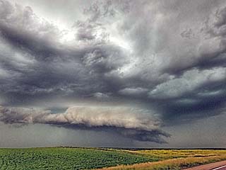
|
View of an HP supercell and wall cloud / rotating portion on the leading edge of persistent outflow during the late afternoon on June 25 pushing east out of Nuckolls / Thayer Counties in Nebraska. The view is to the west. |
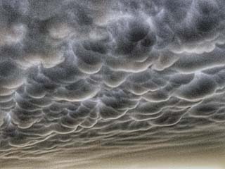
|
Incredible mammatus clouds looming in the sky near Hastings, Nebraska during the early evening of June 25. |
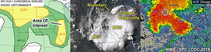
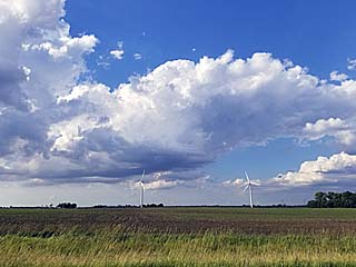
|
Initiation of storms and towering cumulus between Rochelle and Aurora in northern Illinois late in the day on June 26, 2019. |
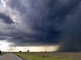
|
Developing supercell storm west of Aurora, Illinois late in the day on June 26. |
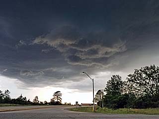
|
A slowly rotating wall cloud is visible on the southwestern side of a developing severe thunderstorm over Kane County (near Aurora), Illinois during the late afternoon / early evening of June 26. |
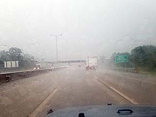
|
High winds, torrential rains, and hail blow through the area of Naperville in the western Chicago suburbs on June 26. The view is to the east on the I-88 tollway. |
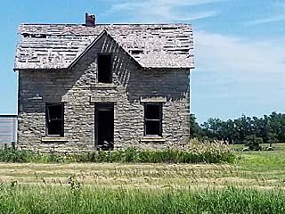
|
While driving through the American Midwest, and headed back to Chicago for "down time", here is one of many old houses quite literally "on the prairie", that are abandoned and slowly weathering away over the past century. |
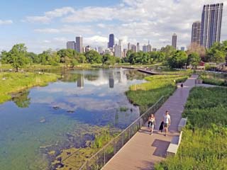
|
Here is a view of the Lincoln Park area (near the zoo) While I was staying in the Chicago area. |
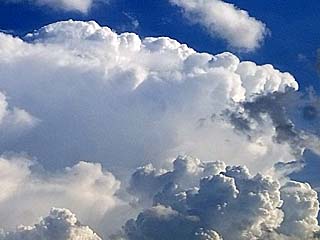
|
View of the top of a severe warned storm over the Chicago area late in the day on June 28. The storm is about 25 miles away and the view is towards the south and southwest. |
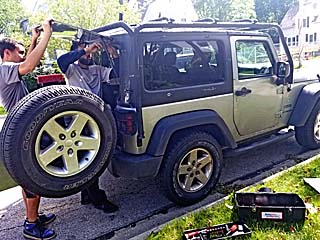
|
While staying in the Chicago area, I managed to get the rear window of the chase vehicle replaced (damaged from the June 21 storm near NE Colorado / W Kansas). |

|
While beginning the long drive back to California and passing through Nebraska on I-80, a distant supercell can be seen looming over the horizon on a confluence axis late in the day on July 8. The storm is to the lower right and is roughly 40 miles away and developing along a confluence axis oriented NW to SE. A very brief tornado was reported with this storm. The view is to the southwest. |
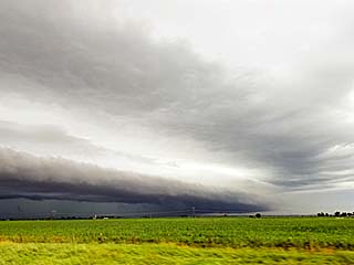
|
Passing a powerful strong and severe MCS of storms, this beautiful shelf cloud can be seen over central Nebraska late in the day on July 8 headed west on I-80. The view is to the northwest. |
|
While continuing west to California, many awesome views of the American deserts and southwest were passed. This is a view of the Colorado river and canyon country in central and western Colorado while headed west on I-70 between Denver and Grand Junction on July 10. |
|
View of Las Vegas, Nevada late in the day on July 10 (while passing through Utah, Arizona, and Nevada on I-15), with desert temperatures approaching 110 deg F ... Almost to California! |

|
That dreadful feeling when you realize the "2019 storm chase season" is ending - Like baseball (or football) season ending for a sports fanatic - Just devastating? Just kidding! Posted this humorous shot just for kicks and see you all out there again in 2020! |
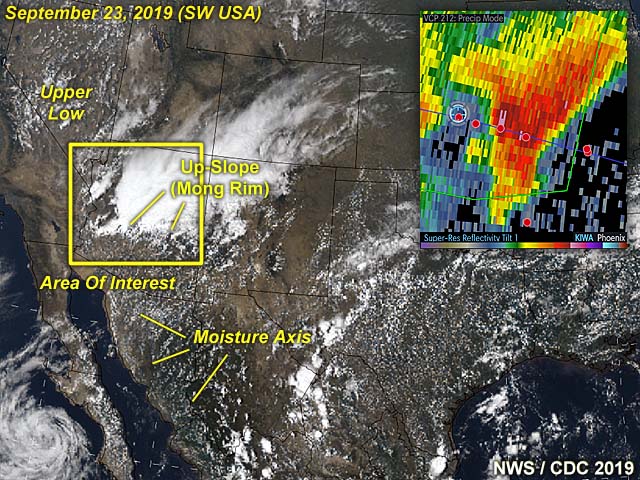
1). Feb 21, 4:00 PM - Observation of a strong thunderstorm over Orange County, California near Anaheim from near Chapman Avenue and Euclid Street. The storm was a cluster of marginally strong thunderstorms producing moderate rain, occasional lightning, and winds gusting near 40 MPH. An area of rotation and small funnel was briefly noted in a small supercell storm that developed near Anaheim before moving to the SE and weakening. The storm also had a weak RFD with gusts near 40 MPH. The storm was caused by surface heating, a low pressure trough, and a strong upper level low to the north (very cold air aloft / cold core environment). Documentation was digital stills. A 2016 Jeep Wrangler was used in this brief chase.
2). Sept 23, 5:00 PM - Observation and indirect penetration of a severe and possibly tornadic thunderstorm from near Centennial in La Paz County, Arizona and eastward along and near I-10 into western Maricopa County north of Buckeye. The storm was a supercell storm for some time. Conditions encountered were heavy rains, hail up to nickel sized, frequent lightning with some close hits, and winds exceeding 50 MPH. The core of this storm was indirectly penetrated. The storm had a striking visual appearance, with striated updraft, inflow tail, and wet RFD slot, unusual for a desert environment. A funnel and rotating wall cloud was observed on the leading edge of this storm before becoming outflow dominant. Conditions causing the storms were surface heating, tropical moisture (from the Gulf of California), an upper level low pressure system, surface trough, and orographic lift (from the Mongolan Rim up-slope). Documentation was digital stills, audio, and HD video. A 2019 Jeep Wrangler was used to chase the storms. A severe thunderstorm watch was also valid for the area until 9 PM MDT (8 PM PDT).
This concludes the chase log for the central United States and Midwest for ANY OTHER chases in 2019 not part of a special section (especially those for single-day "spot" chase trips). The summary includes a total of 2 observations. Out of the observation, there were 2 severe thunderstorms. The main chase vehicle conducting these chases was a 2016 Jeep Wrangler. This information was prepared exclusively for the National Weather service and the team of Skywarn storm spotters.
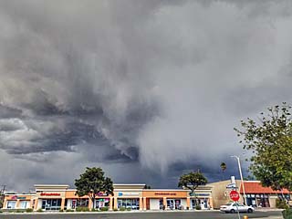
|
A high-based supercell develops in a cold-core environment on February 21, 2019 over northern Orange County near Anaheim, California during the late afternoon. |
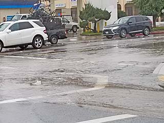
|
Street flooding on February 21, 2019 in Anaheim in Orange County, California during an above-normal rain event. |
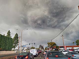
|
Another view of a rare supercell storm, developing in a cold-core environment (post frontal) on February 21, 2019 over Orange County, California. The upper-center of the image is the rotating portion of the storm / mesocyclone. |
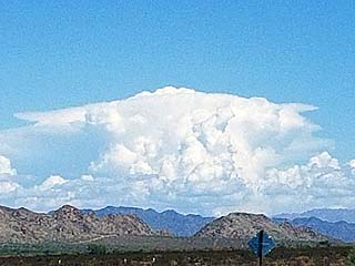
|
A developing supercell looms over the desert / mountainous terrain looking east from eastern California into far western Arizona. This was a supercell storm near Blouse, Arizona on September 23, 2019. |
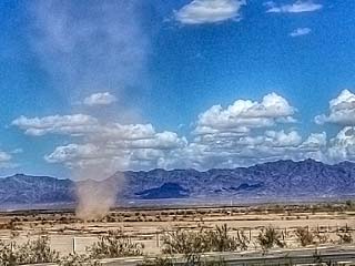
|
A dust devil churns just north of Interstate 10 near the eastern California / western Arizona border on September 23, 2019. |
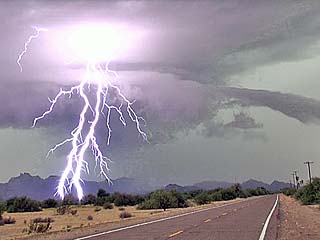
|
Incredible lightning and supercell structure (note beavers tail to the right) in La Paz County, Arizona on September 23, 2019. The view is to the west and southwest. |
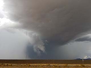
|
RFD region with wall cloud and forward-flank funnel as a supercell storm approaches western Maricopa County, Arizona on September 23, 2019. |
HTML File "mwcl2019.htm" - Developed By Chris Collura
To Return To The HOME Page Of This Site Click The "INDEX.HTM" Link Here!