
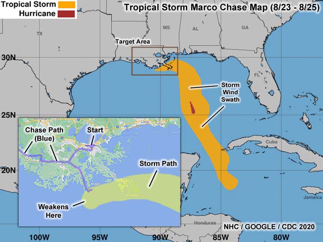
| This area shows pictures taken from observations of tropical storm Marco in southern Louisiana in late August 2020. Marco began in the tropical Atlantic as a wave that came off Africa near the Cape Verde Islands in mid August of 2020. The system moved through the Caribbean towards Central America, then turned north as a tropical depression. The system entered the southern Gulf of Mexico around August 22 and 23. The storm intensified quickly, becoming a tropical storm, then a category one hurricane in the central Gulf of Mexico late on the 23rd. After that, dry air and wind shear increased significantly over Marco, rapidly weakening it to a tropical storm by August 24. Taking aim at the MS / LA border area, the shear de-coupled the mid level circulation from TS Marco, and an exposed, low-level center, turned west instead. Still weakening, Marco grazed the southern to SW Louisiana coast by early morning on August 25, where it weakened to a tropical depression. My observations of this system were not much and done mainly in the Grand Isle area, mainly observing high surf. I flew out from California (where I was staying at the time) to Louisiana to try to chase Marco, but the main interest was hurricane Laura a few days later in SW Louisiana. The section here is for observations in southern Louisiana - Particularly near Grand Isle in Jefferson Parish. |
| CHASER NAME | HOME CITY | CALLSIGN | OCCUPATION |
| CHRIS COLLURA | DEERFIELD BEACH, FL | KG4PJN | COMPUTER CONSULTANT |
|
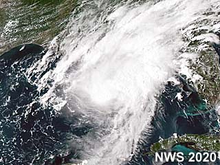
This a visible satellite image of hurricane Marco as it was in the central Gulf of Mexico mid-day on August 23, 2020. This is when it reached peak intensity, with 75 to 80 MPH winds, making it a category 1 hurricane on the Saffir-Simpson scale. After this, Marco encountered significant vertical wind shear and dry air, and rapid weakening commenced there after. |
|
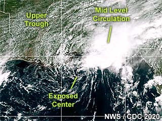
This an annotated visible satellite image of highly sheared tropical storm Marco during the afternoon of August 24. The storm has decoupled from its thunderstorm convection and left an exposed low-level center (with a distinct swirl), drifting westward towards southern Louisiana. After this, it continued west and northwest and weakened to a tropical depression, and dissipating on August 25. |
|
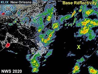
This is an annotated radar image (base reflectivity) around noon on August 24, showing tropical storm Marco approaching the Mississippi delta as a highly disorganized system. The "X" marks the approximate position of the highly diffuse low-level center at the time. |

|
While flying in from Houston, TX to New Orleans, LA late on August 23, the view of hurricane Marco's outflow and edge can be seen looking towards the southeast at high altitude. Marco was a hurricane at the time, but was to weaken quickly thereafter due to vertical wind shear and dry air entrainment. Note the high altitude cirrus outflow above, and edge of the hurricane cloud shield, feeder bands, and darker "bar" of the storm to the left-center of the picture. |

|
View of the levee of Lake Pontchartrain during the morning of August 24. The level of the street to the right is BELOW the level of the estuarine lake. This area was devastated with flooding during hurricane Katrina in 2005. Here it is merely a breezy day with choppy lake conditions. |
|
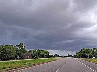
Approaching a convective band of showers and thunderstorms as tropical storm Marco approaches Grand Isle, Louisiana during the afternoon of August 24. The view is to the southeast. |

|
View of high surf (4 to 6 foot waves) at the beach in Grand Isle, LA during the afternoon of August 24. |
|
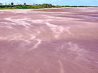
Winds of about 30 to 35 MPH blows sand from east to west along the beach in Grand Isle, LA during the afternoon of August 24. |
|
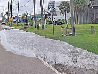
Minor street flooding in Grand Isle, LA during the afternoon of August 24. |
|
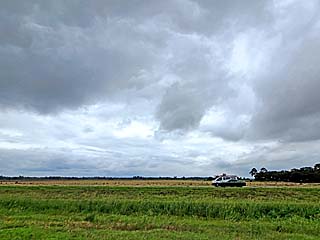
The tropical storm comes ashore and weakens to a tropical depression near Lafayette, Louisiana during the morning of August 25. Here, looking southeast, the circulation center (brighter sky) can be seen, with a complete wind shift around the weakening storm. |
HTML File "marco20.htm" - Developed By Chris Collura
To Return To The HOME Page Of This Site Click The "INDEX.HTM" Link Here!