
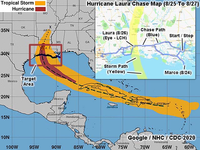
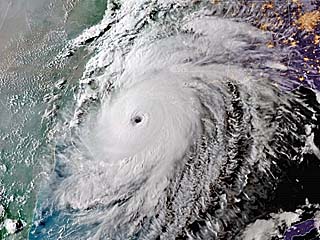
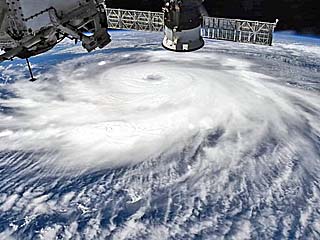
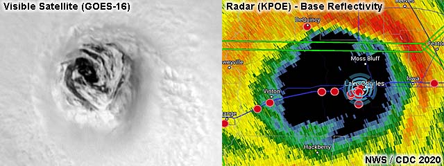
| This area shows pictures taken from the interception and observation of extremely devastating and catastrophic category-four hurricane Laura in southwest Louisiana near Lake Charles in Calcasieu Parish, including its landfall during the night of August 26-27, 2020. This devastating storm originated as a "Cape Verde" tropical disturbance that originated off the African coast in mid August of 2020. During its long journey across the tropical Atlantic, the storm formed into a tropical depression east of the windward islands, moving quickly west. Upon approach to the US Virgin Islands, the depression became a weak tropical storm, passing by Saint Croix, then south of Puerto Rico. After that, the developing storm went directly over Hispaniola (Dominican Republic and Haiti), which would normally disrupt and dissipate cyclones due to rugged terrain. Tropical storm Laura, surprisingly, remained intact is it passed back over water, and over its next "hurdle", eastern Cuba. Again, the storm maintained integrity over the land mass, before re-emerging over the Caribbean Sea during the day on August 24. Now over warm water is began re-organizing, struggling a final time crossing western Cuba and into the southern Gulf of Mexico late on the 24th. The storm continued west and northwest, reaching hurricane intensity during the morning of August 25. Continuing northwestwards, Hurricane Laura entered an atmospheric environment of low shear and beneath an upper-level anticyclone. Rapid, to even explosive intensification, ensued during much of the day on August 26, and the storm reached 150 MPH (less than 24 hours earlier it was 75!) as it approached SW Louisiana. The storm made a midnight landfall near Cameron and to the east of Holly Beach, Louisiana on August 26-27 as a high-end category 4 hurricane, the first of such in that area in recorded history. The storm continued inland during the wee morning hours, crossing over Sulphur and Lake Charles in Calcasieu Parish. These areas took a direct hit from the violent right-front quadrant of the storm, and experienced the passage of the rain-free eye. The storm crossed the I-10 corridor and continued to the north, later turning towards the northeast on August 27. The storm, now inland, finally felt some vertical wind shear it managed to avoid until landfall, weakening to a category one hurricane by the afternoon of August 27 in northern Louisiana. The storm weakened further to a tropical storm over southern Arkansas during the evening of the 27th, then to a tropical depression overnight, and dissipating over central to northern Arkansas, having completed a full re-curvature. I had already traveled out to Louisiana (from Los Angeles) on August 23, anticipating an intercept of far-weaker Marco, which encountered vertical wind shear and rapidly weakened on August 24. On August 25 I headed west, targeting a swath anywhere from Lafayette, Louisiana to Galveston, Texas as a landfall point. Late in the day on August 25, I decided a westward option, maybe near Port Arthur, would be a good choice. Lack of hotels in that area and evacuation traffic on I-10 forced me to spend the night in Houston, assessing a final target area during the morning of the 26th. I headed back east towards Port Arthur, then south of there along the coastal road (SR 82) through Holly Beach and back up SR 27 to Lake Charles. Well in advance of the storm, Holly Beach was already experiencing storm surge flooding and high surf. Staying on the coast was simply not possible with a major hurricane making landfall due to lake of shelter / low elevation. Observations of the storm landfall and subsequent passage of the hurricane core was done in Lake Charles, which experienced a direct hit just after midnight (early on August 27th). My observations were done with a few other storm chasers, including Tim Marshall and Scott Peake, atop a reinforced parking garage (with permission from police and hospital staff) near the Christus Patrick Medical Center. The eastern edge of the storm eye also passed over, with breezy conditions and no rain, and stars briefly visible through cloud breaks overhead, surrounded by lightning. The second side of the storm was less intense than the forward-right side. I got some sleep and made my way out of Lake Charles during the morning daylight of August 27. The city of Lake Charles suffered extensive damage, with power poles and trees blocking most roads, roofs torn off buildings, homes destroyed, flooding of many roads, and debris everywhere. I helped a few local people there, also giving them some water, then made my way back to I-210 / I-10 to head east. A barge was also noted against the bridge in Prien Lake. Farther east, near I-10, inland storm surge flooding was noted, along with a toxic chemical fire on-going. Downtown Lake Charles also had significant damage, with a radio tower collapsed and many windows blown out on the Capital One tower. I headed east on I-10 and got clear of the heaviest damage path. Unfortunately, my vehicle hit an isolated piece of metal / power insulator nearly invisible on I-10 east bound. Both passenger tires blew out, as I rolled to a stop near Iowa, Louisiana. Without cell service, I had to put the spare on the front, and slowly limp eastward towards Jennings, and distance of about 15 miles. The tire and rim were completely destroyed at this point. From there, and after many tries, I contacted AAA and was towed to Lafayette, where I was able to exchange rental vehicles and file paperwork. With the new vehicle, I continued east to spend the night in New Orleans, changing my return from the 27 to the 28th. On August 28, I returned the rental vehicle and flew back to Los Angeles. The main chase vehicle was a 2020 Nissan Rogue, and the exchanged one was a 2020 Chevy Malibu. Total estimated mileage was about 1,000 miles for the entire trip. Note - This page may take a while to load on some SLOWER connections! |
| CHASER NAME | HOME CITY | CALLSIGN | OCCUPATION |
| CHRIS COLLURA | DEERFIELD BEACH, FL | KG4PJN | COMPUTER CONSULTANT |
| SCOTT PEAKE | ALLEN, TX | N/A | INDEPENDANT FILM |
| TIM MARSHALL | FLOWER MOUND, TX | N/A | CIVIL ENGINEER |
| TIM MILLAR | LAKE WORTH, FL | N/A | PILOT |
|
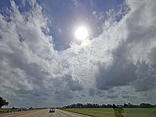
Headed eastward along I-10 between Houston and Port Arthur / Beaumont, Texas during the morning of August 26, 2020. The sharp edge of the high altitude cirrus outflow associated with hurricane Laura streams over a deck of low towering cumulus clouds. |
|
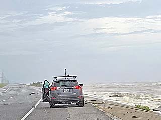
Looking east on Highway 82 towards Holly Beach in SW coastal Louisiana during the early afternoon of August 26. Brian Emfinger's vehicle is in the foreground. With landfall still over 10 hours away, waves and surge area already crossing portions of the roadway. |
|
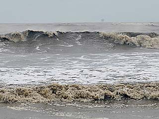
Waves at least 10 feet high affect the coastal areas west of Holly Beach on August 26. Note the oil rig on the horizon. |
|
Coastal flooding / storm surge in Holly Beach during the early afternoon of August 26. |
|
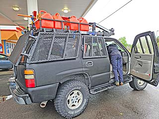
Storm chasers at a gas station off Prien road in Lake Charles during the late afternoon of August 26. |
|
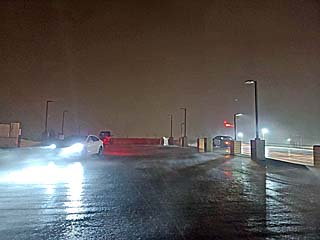
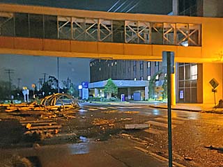
Parking garage top during the late evening of August 26, near the Christus Patrick Medical Center. Several other chasers were there, including Scott Peake and Tim Marshall. This is where we rode out the full fury of the storm, in near darkness and with a deafening roar during the night. In this picture, the hurricane forced winds have just reached Lake Charles. |
|
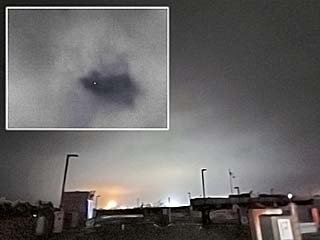
During the early morning hours of August 27, part of the calmer eye passes over our location in Lake Charles. I measured a pressure of 954 mb. Some chasers a bit west near Sulphur measured 948 mb. The winds died down a lot but did not completely stop (probably because of meso-vortices on the east / right side of the eye). The rain let up completely, with partly to mostly cloudy skies and fog to the west. The inset is looking up through a break in the low clouds inside the eye, with stars briefly visible. Lightning was noted all around us at this point, with a brief glimpse of a "stadium effect" through the cloud breaks as the eyewall was illuminated. |
|
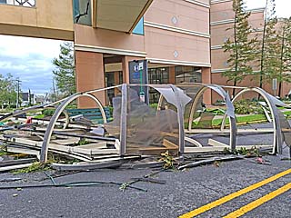
Glass debris and crossover damage at the Christus Patrick Medical Center just after passage of the eye of hurricane Laura during the wee morning hours of August 27. |
|
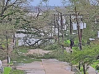
Daylight reveals numerous downed trees near the Christus Patrick Medical Center during the morning of August 27. |
|
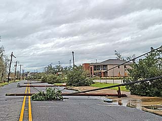
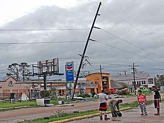
Downed power poles and powerlines blocking the roadway east of the Christus Patrick Medical Center. |
|
Structural damage at the Christus Patrick Medical Center during the morning of August 27. |
|
Dazed and confused people wandering around the devastated south side of Lake Charles during the morning of August 27. I offered to give these folks a ride, and gave them extra food and water I had. |
|
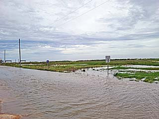
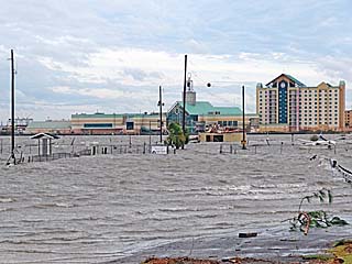
The storm surge associated with hurricane Laura penetrated 20 to 30 miles inland in some places. In this picture, near I-10, severe flooding is noted during the morning of August 27. This is also near a marina that has been destroyed. |
|
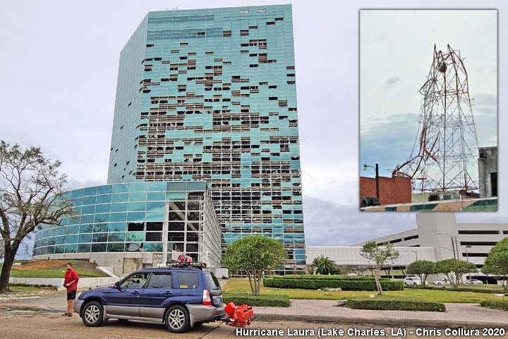
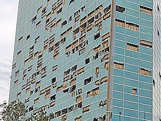
Shattered and blown-out windows of the Capital One Bank tower building near downtown Lake Charles during the morning of August 27. |
|
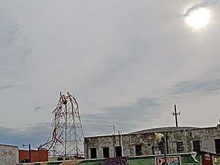
Downed TV station tower and hazy sun in downtown Lake Charles during the morning of August 27. |
|
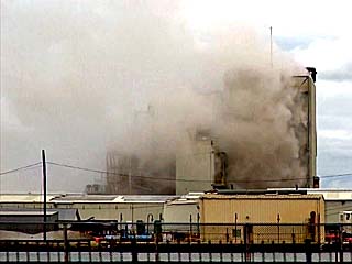
This is a toxic chemical fire and leak that occurred just south of I-10 on the east side of Lake Charles during the morning of August 27. This released a toxic cloud of possibly deadly chlorine gas (note beige / greenish color). |
|
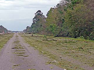
I-10 remained full of debris and damage that continued about 25 miles east of Lake Charles. The view here is to the east. |
|
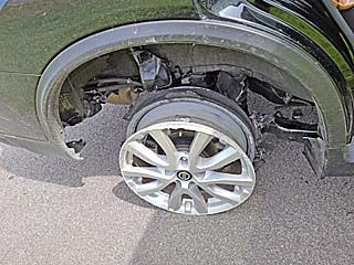
Blown out tires on the chase vehicle, which damaged the wheel well on the rear passenger side. There was no way to get any help for this, with no cellular service nor towing service available. The only choice was to crawl slowly east on I-10 to Jennings, eventually getting a tow to Lafayette, and getting a replacement vehicle there to make it back to New Orleans. |
|
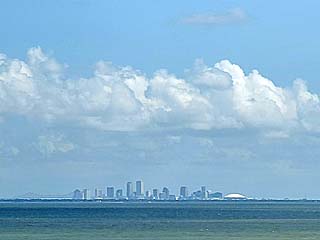
View of New Orleans on August 28 via the Lake Pontchartrain causeway before flying out late in the day. |
|
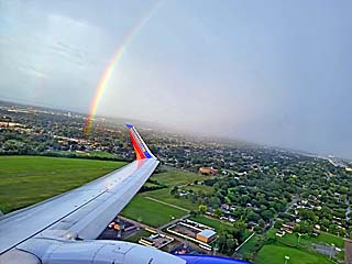
Beautiful rainbow flying out of New Orleans late on August 28 and headed back towards Houston / Los Angeles. |
HTML File "laura20.htm" - Developed By Chris Collura
To Return To The HOME Page Of This Site Click The "INDEX.HTM" Link Here!