
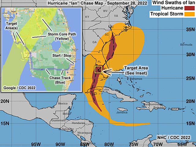
| Hurricane Ian was a devastating high-end category 4 hurricane that slammed into southwestern Florida on September 28, 2022. The storm began as a tropical wave moving off Africa and into the eastern Atlantic and past the Cape Verde Islands before September 19. This system did not start developing until it was near the Windward Islands and in the eastern Caribbean sea, forming into a tropical depression on September 23, and tropical storm "Ian", a day later. The storm was originally hindered by the high-altitude (clockwise) outflow from Hurricane Fiona, which was north of Bermuda and making landfall in Atlantic Canada. This produced northerly shear on Ian, slowing its intensification, but abated on September 25. By September 27, Ian was a powerful hurricane, rapidly intensifying, and turning towards the north, passing over Cuba during the evening of September 27 with 125 MPH winds. Western Cuba had little effect on the structure of hurricane Ian, and the storm continued north and eventually northeast. With such track trends more east than north, the hurricane avoided atmospheric conditions (dry air and vertical wind-shear) that would disrupt it, and remained in an area of upper air divergence and high-pressure / anti-cyclonic outflow at high altitude (above FL 340). The storm had an eyewall replacement cycle early on the 28th, and began rapidly intensifying, reaching a staggering 155 MPH (and central pressure of 936 mb) offshore of SW Florida. Catastrophic (high-end category 4) hurricane Ian made its first landfall during the late morning / early afternoon of September 28 near Cayo Costa, Florida with winds at least 150 MPH, then a second landfall near Punta Gorda, Florida in the afternoon with at least 145 MPH winds. This was nearly the same track hurricane Charley, another category 4 storm, took in August 2004, but Ian was far larger than Charley. The right eyewall caused devastating storm surge and / or wind damage in Fort Myers, Sanibel Island, and across the path from Lee and Charlotte Counties. The storm moved inland during the evening of September 28, leaving SW Florida with catastrophic damage in its wake. During the night, Ian weakened to category 3, past Orlando, and moved off Florida, re-emerging into the Atlantic as a strong tropical storm on September 29 near Daytona Beach. Ian was not done, as it was now over the Gulf Stream current. The storm strengthened back to an 85 MPH subtropical hurricane (interacting with strong wind-shear and a frontal zone) late on September 30, making landfall near Georgetown, South Carolina. This final landfall caused extensive flooding in coastal South Carolina. By October 1, Ian had moved inland as a non-tropical remnant low, and dissipated near North Carolina and Virginia. Note - This page may take a while to load on some SLOWER connections! |
HURRICANE IAN - A DEVASTATING STORM IN FLORIDA
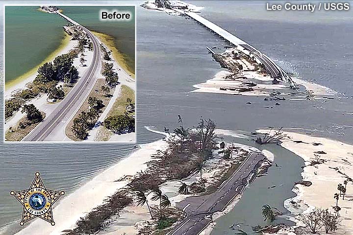
SW FLORIDA COASTLINE CHANGED FOREVER
| CHASER NAME | HOME CITY | CALLSIGN | OCCUPATION |
| CHRIS COLLURA | DEERFIELD BEACH, FL | KG4PJN | COMPUTER ANALYST |
|
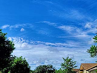
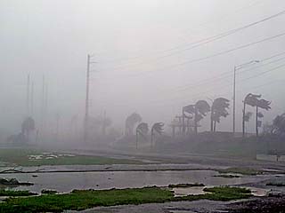
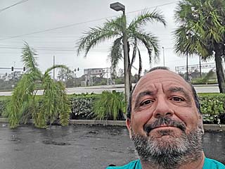
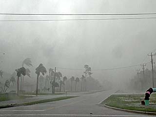
A first sign of "very bad things" to come. On Monday, September 26, the edge of the cirrus and high-altitude outflow of hurricane Ian can be seen looking south from Broward County, Florida. |
|
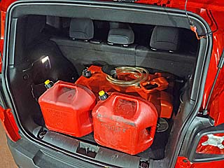
Fuel cans topped off and in the back of my new chase vehicle, a 2022 Jeep Renegade on September 27, as I prepare to chase hurricane Ian. |
|
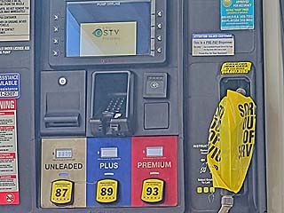
Most gas stations are closed in a hurricane - That's why we have to bring our own extra fuel. Fuel pumps are often closed and nozzles bagged-up and locked, like this one in Charlotte County, Florida during the morning of September 28. |
|
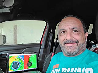
Myself, with the radar imagery on my laptop in the background, in a covered parking area near Pine Road in Englewood, Florida waiting for hurricane Ian to arrive. |
|
Eyewall of Hurricane Ian reaches Englewood from the south during the early afternoon. |
|
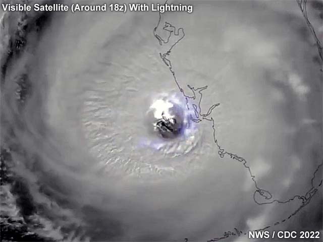
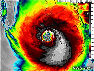
Impressive IR (infrared) satellite image of category 4 hurricane Ian nearing the SW Florida coast, about the same time I was reaching Englewood. |
|
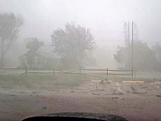
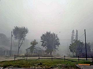
Continued eyewall conditions in Englewood, with a roof coming off the second house from the left across the bottom part of the picture. |
|
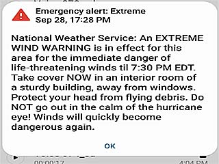
To no surprise, a terrifying alert message like this appears on my phone while approaching the most intense part of the storm! |
|
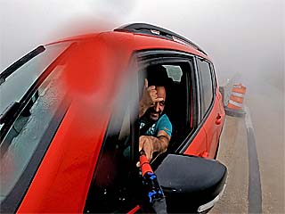
With the eye jogging east towards Charlotte Harbor, I made a daring (and extremely risky) drive through the northern eyewall of Ian to re-position and get into the storm eye! Here I am near Murdock, Florida, at a bridge crossing part of Charlotte Harbor while being buffeted by extreme winds and violent rain. |
|
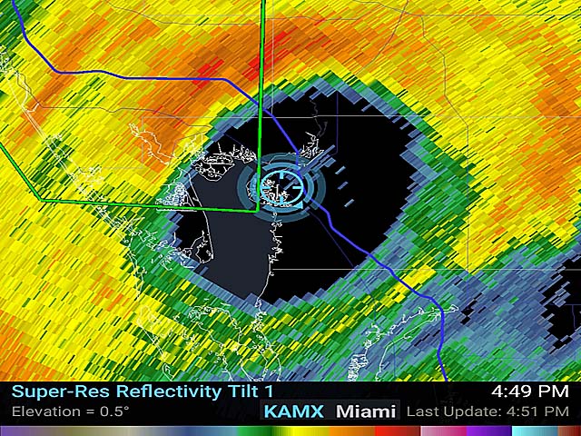
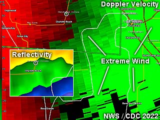
This is a close-up radar image (doppler velocity) of the northern eyewall of Hurricane Ian, just before 4 PM EDT. The inset is the base reflectivity, showing the intense precipitation gradient as one procedes southward from the eyewall and into the eye. My location is depicted by the white circle, while green dots denote other storm chasers. Note I am in a "relatively" weaker area of winds, rushing to drive east and into the path of the eye before areas of extreme winds hit (intense green shades on the Doppler display). |
|
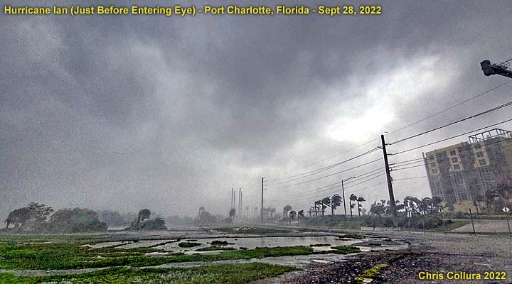
Some ceiling / store facade pieces fall while under a store-front in Port Charlotte in the afternoon of September 28. |
|
Intense inner eyewall, and just about to enter the eye, on the north side of the Charlotte Harbor bridge and across the Sunseeker complex under construction. The view is to the SSW. This inner "ring" is a narrow band, only a few miles wide, tucked inside the inner edge of the main eyewall and encountered just before entering the eye. Unfortunately, most of the kinetic energy is contained in this region, and winds here are gusting near 140 MPH. |
|
Reaching the southern edge of the Charlotte Causeway bridge, and near Punta Gorda, the wind begins dropping dramatically. I am almost in the eye. In this picture, looking NNW back across the bay, and the spray and poor visibility in the 140+ MPH eyewall looks like fog in the background. In the foreground, shallow and falling water can be seen, but not as windy. Note the spray "swirl", probably one of many mini-swirls, in the center of the picture! |
|
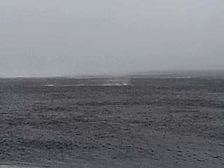
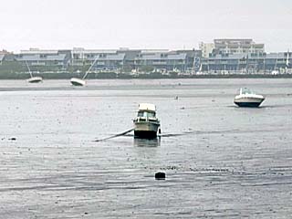
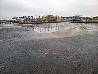
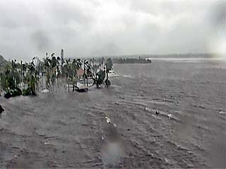
Powerful offshore winds on the north side of Ian's eye force a "negative" (or anti) surge where the water level suddenly drops. This leaves a few boats stranded on the seafloor of Charlotte Harbor. |
|
Another view showing the dramatic drop in water level as winds push most of the water out of Charlotte Harbor. This is extremely dangerous for anyone attempting to "explore" the seafloor. Once the eye moves over, and especially with the winds shifting from easterly to west, the wall of water (bore) will snap back like a tsunami, and after that, the surge again will be HIGHER than the normal water level. |
|
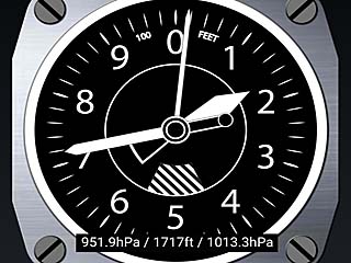
Altimeter app on my phone before entering Ian's eye, with a pressure of about 952 mb. Note this is nearly 1,700 to 1,800 feet of the lower atmosphere that has been "removed" (pressure deficit) near the storm core and in a circular area 40 miles wide. Also, while in the inner eyewall, the needle on the display could be seen swinging back and forth 50 to even 100 feet, directly related to pressure in my ears - And usually before a destructive wind gust - Oweing to the choppy and turbulent flow of air in the eyewall and / or mini-swirls. |
|
Myself standing at an abandoned gas station in Punta Gorda, Florida during the late afternoon of September 28, and in the calm eye. Now is a good time to fuel up the vehicle (using the extra fuel I brought along). |
|
Damage and trees down in the calm eye of the storm. Not a single leaf was moving, it was dead calm, with a brightening sky overhead. |
|
View looking towards the clearer eye of Ian as it was continuing north and northeast of Punta Gorda. The sky was much brighter, with a stadium effect visible at times, but mostly clouded over. |
|
By early evening, and a mere mile or two west of the calm eye, the second half / backside of the hurricane approaches. The winds go from calm and begin gusting back up to 130+ MPH, but are from the northwest, instead of east and southeast, as before the eye. I made a hasty retreat back east and south, taking advantage of the slow motion of the storm, temporarily re-entering the eye and heading south on I-75. |
|
View of the Caloosahatchee River, about 20 to 30 miles inland from the landfall point and Fort Myers. Even well inland, the combination of historic storm surge, as well as heavy rains, causing the river to crest, caused severe flooding far away from the beaches. Winds here are still gusting near 100 MPH from the west. Two jet skis, half sunk, are drifting in the surge from center and to the right. The view is also to the west. |
|
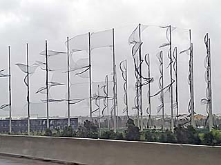
Damage to a "Top Golf" facility near I-75 in Fort Myers. The netting has been entirely shredded by the winds of hurricane Ian. |
|
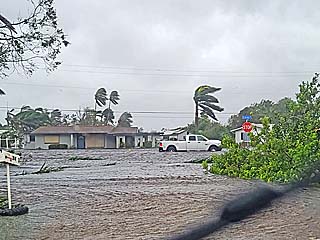
Inland flooding, far from the coastal areas and beaches, affecting homes in eastern Fort Myers and near the Caloosahatchee River. |
|
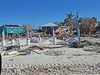
Destruction in Fort Myers beach about a month after hurricane Ian ravaged the area. The pilings are all that remains of a structure on the east side of the roadway. Note the drone to the upper left flying overhead. |
|
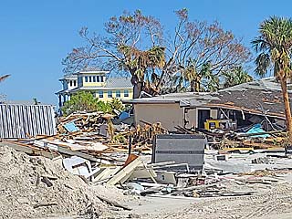
More catastrophic damage from storm surge a month after hurricane Ian in late October 2022. |
|
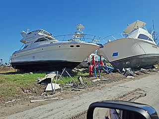
Large boats high and dry along the side of the road a midst devastation on San Carlos Island a month after the storm. |
|
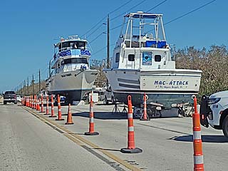
Large fishing boats / yachts well inland and dry along the side of San Carlos Blvd. These will have to be moved with a crane or dismantled. |
|
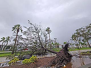
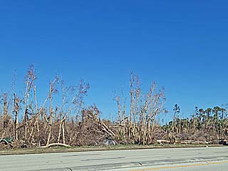
Forest with many trees blown down by hurricane Ian well inland near Fort Myers, Florida and near Highway 41. |
HTML File "ian22.htm" - Developed By Chris Collura
To Return To The HOME Page Of This Site Click The "INDEX.HTM" Link Here!