
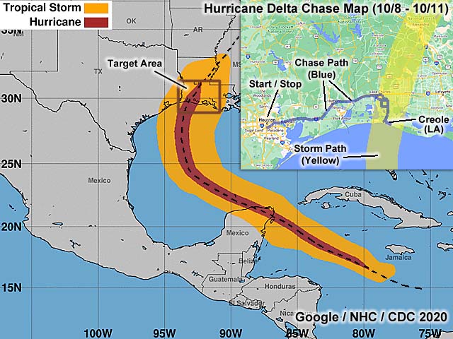
| This area shows pictures taken from the interception and observation of category-two hurricane Delta in southwest Louisiana from southeast of Lake Charles in Calcasieu Parish, and into Creole in the Cameron Parishes. Creole was the landfall point of Delta during the afternoon and evening of October 9, 2020. This dangerous storm originated as a tropical disturbance (one of the late season waves off the African coast) that interacted with the Central American monsoon in the NW Caribbean. This system formed into a tropical depression east of the Yucatan Peninsula and south of Cuba, moving west and northwest. Upon approach to the Mexican coast (NE Yucatan), the depression became a tropical storm, and explosively intensified into a category-four hurricane, with 140 MPH winds, east of the Yucatan Peninsula around October 5. This hurricane weakened (due to the remnants of tropical storm Gamma), and passed over the NE tip of Yucatan as a category-two storm, and producing wing gusts over 100 MPH in Cancun. By October 6, the storm passed north of the Yucatan Peninsula and re-emerged into the southern Gulf of Mexico. Hurricane Delta slowly moved across the southern and western Gulf of Mexico from October 6 through the 8th, and re-intensified to a major hurricane, with winds of 120 MPH (category 3). The storm eventually turned northwest and north, beginning it's re-curvature, and approached the Gulf Coast during the day on Friday, October 9. The storm remained strong, and weakened a bit to a strong category-storm, with 105 MPH winds, owing to cooler waters near the coastline off the Gulf Coast / SW Louisiana. At about 6 PM, CDT, the center of hurricane Delta made landfall at Creole, Louisiana, and headed NNE into the state with 100 MPH winds. This hit the same area devastated by hurricane Laura just 6 weeks prior. Hurricane Delta moved inland during the night of October 9, and began quickly weakening. The storm weakened to a tropical storm / depression by the late day of October 10, and degenerated to a remnant low past Jackson, Mississippi late on October 10 and early on October 11. I traveled out to Houston late in the day on October 8, via a delayed flight from Los Angeles. I picked up the rental vehicle and headed east to near Baytown off I-10, and to a hotel where another storm chaser, Derek Sibley (meteorologist working in Midland, Texas), who drove out there earlier on October 8. I had an issue booking my hotel room there, and stayed with Derek for the night. The next day, October 9, we woke up and decided to chase in my vehicle, a 2020 Nissan Versa. Derek had some extra supplies, including food, water, and fuel, and packed them into my vehicle. Derek left his vehicle at the hotel in Baytown, and we continued east in mine, targeting the area southeast of Lake Charles, Louisiana. We continued east on I-10 to east of Lake Charles, and south on SR 27, targeting a small coastal / fishing town of Creole as the expected landfall point. Hurricane Delta approached the area, and we cautiously decided to "ride out" the powerful right-front quadrant of the hurricane, atop an elevated concrete slab (not much of Creole was left after Laura passed through), which was the remnants of a business. The storm made landfall by late afternoon / early evening at our location. Doug Kiesling (from Minnesota) was also in the area, and I caravanned with him at times. As the eyewall hit, the storm surge and strong winds (gusting over 100 MPH) peaked, and I hastily made my way north of Creole on SR 27. Much of this road was underwater, with grass and debris along it. Doug Kiesling found a parking ramp, and rode out the storm back in Creole there. The calm eye was also observed, with blue sky briefly overhead, dead calm winds, birds / bugs flying overhead, and a pressure measured around 972 mb. Inside the calm eye, the waves and surge made a low audible "roar" to the south, and quickly began rising northward up SR 27 a few miles north of Creole. The second half of the storm came in around 7:30 PM CDT, near dusk, and was observed along SR 27 north of Creole, with wind gusts near 80 MPH once again, albeit lighter rains. We continued north on SR 27 and back towards the SE side of Lake Charles. A slow leak developed in one of our tires, and many roads were blocked by severe flash flooding. We managed to make our way through Lake Charles via I-210 to I-10 west, and eventually out of the storm to the hotel at Baytown. Derek picked up his vehicle there, and we headed west back into Houston, spending the night there by the airport. By October 10, Derek continued on his separate way back home to Midland, Texas, and I stayed an extra day on Houston, enjoying the airshow there during the afternoon of October 10. On October 11, I left Houston, and flew back into Los Angeles. Total mileage was 473 miles for the entire trip. Note - This page may take a while to load on some SLOWER connections! |
| CHASER NAME | HOME CITY | CALLSIGN | OCCUPATION |
| CHRIS COLLURA | DEERFIELD BEACH, FL | KG4PJN | COMPUTER CONSULTANT |
| DEREK SIBLEY | MIDLAND, TX | N/A | METEOROLOGIST |
| DOUG KIESLING | ST CLOUD, MN | N/A | MEDIA / STORM-CHASING VIDEO |
|
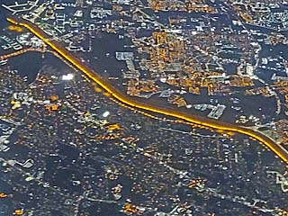
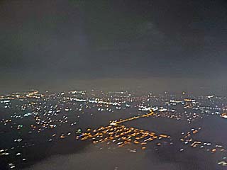
This picture is looking down at the US / Mexico border while overflying El Paso, Texas en-route to Houston from Los Angeles, California on a delayed flight on October 8, 2020. The distinct "yellow" line is the border and is lit by low-pressure sodium lights. Mexico is to the upper-right and the USA (Texas) is to the lower-left. |
|
Landing in Houston, Texas on a rainy and cloudy night via a delayed flight on October 8. The goal is to get in, secure the rental vehicle (before the place closes), and rush east to Baytown, Texas to meet up with meteorologist Derek Sibley who booked a hotel room there (many rooms were sold out due to evacuations from Louisiana). |
|
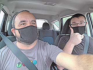
Myself and meteorologist Derek Sibley in the chase vehicle, a 2020 Nissan Versa, and heading east on I-10 to Lake Charles, Louisiana during the late morning of October 9, 2020. We still observed precautions due to the Covid-19 pandemic. |
|
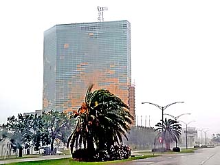
The bank building in Lake Charles, Louisiana sustained heavy damages in late August from hurricane Laura. Many of the windows that were blown out were replaced with plywood. |
|
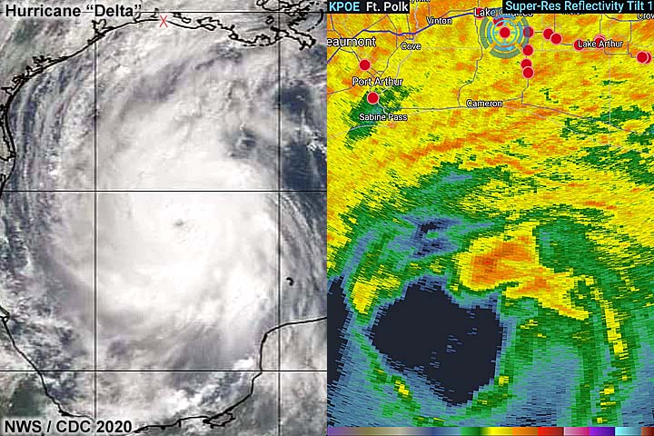
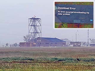
This is a view of the KLCH (NWS WSR-88D) radar site to the southeast of Lake Charles. The site was destroyed during hurricane Laura in late August and is yet to be fixed. In the inset, an error message appears trying to access LCH via RadarScope. During hurricane Delta, storm chasers were forced to use KHOU (Houston) or KPOE (Fort Polk) for radar data. Supposedly a mobile Doppler feed was available for Lake Charles, but the link for it did not refresh. |
|
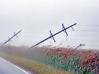
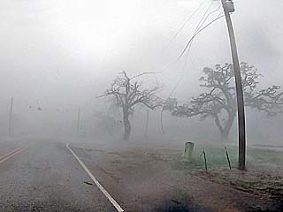
Power poles west of SR-27 between Lake Charles and Creole, LA are down during the afternoon of October 9. These were downed by Laura as well. |
|
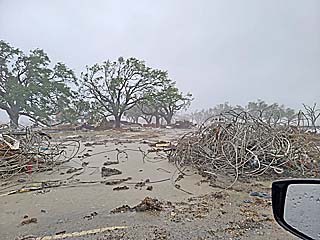
Twisted rubble and debris along the sides of the road north of Creole, LA. This shows how devastating the storm surge in hurricane Laura must have been there. Debris and rubble was noted strewn across roadways and marshland, and with rising surge and flooding from hurricane Delta, which affected the same area devastated by hurricane Laura by only 5 or 10 miles. |
|
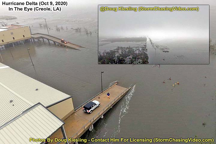
Meteorologist Derek Sibley taking wind and pressure measurements atop an elevated concrete slab (where a building stood before hurricane Laura) in Creole, LA during the afternoon of October 9. |
|
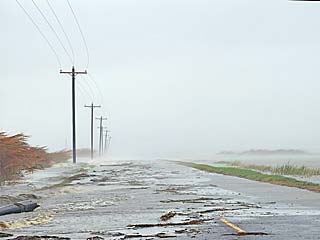
Rising storm surge and winds cutoff the route to Rutherford Beach later in the day on October 9. |
|
Powerlines whip as the eyewall of hurricane Delta reaches Creole, LA late in the day on October 9, packing winds over 100 MPH. |
|
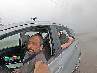
Myself and meteorologist Derek Sibley in the chase vehicle taken from a GoPro 8 Hero camera looking back towards us. We were able to take wind and pressure measurements throughout the storm. |
|
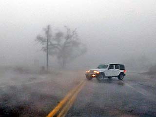
Storm chaser Doug Kiesling in his Jeep rental vehicle as the storm eyewall rages in Creole, LA. |
|
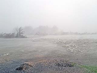
Rising storm surge in the eyewall of hurricane Delta during the afternoon of October 9. There are actually fish jumping in this fast moving water across the roadway! |
|
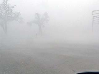
Near "whiteout" conditions of violent (horizontal) rain and 100+ MPH wind gusts in Creole, LA. |
|
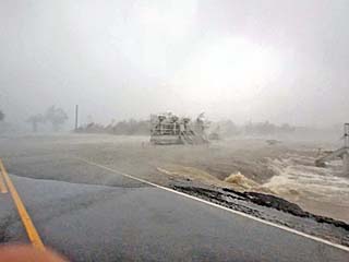
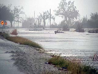
Swift moving water covers the roadway and rushes inland, forming a waterfall over the flood gates and road bed! This surge is rapidly rising from the south, coming in with the eye and core of the hurricane. The eye of hurricane Delta is also approaching from the southwest (brightening sky) during the early evening of October 9. |
|
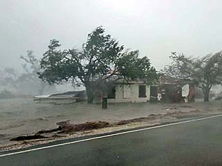
A destroyed house (from hurricane Laura) being flooded and damaged again by the "second blow of a one-two punch" of hurricane Delta during the early evening of October 9. |
|
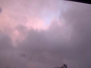
Blue sky peeking overhead as the eye of hurricane Delta makes landfall in Creole, Louisiana at around 6 PM CDT on October 9. The winds are rapidly dying down at this point, but the surge water is continuing to rush in. |
|
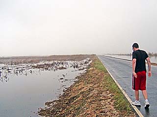
Meteorologist Derek Sibley standing in the roadway (SR 27) north of Creole, LA in nearly dead calm winds inside the eye of hurricane Delta. The pressure we measured was about 972 mb. There was a low, foggy, cloud layer that sometimes broke with brief glimpses of blue sky overhead. |
|
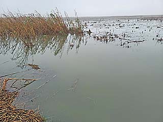
Rising surge water looking south along SR 27 in the eye of hurricane Delta during the evening of October 9. Birds are flying overhead and a strange fog is in the still air. You can hear a low "roaring" to the south from the surge inundating Creole. |
|
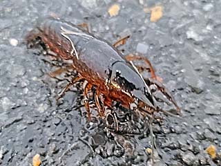
One of many craw-fish crawling along the roadway in the eye of hurricane Delta. |
|
Complete "dead calm" conditions with nothing moving and the water having a smooth mirror appearance to it. It would only be a few minutes before the second half of hurricane Delta comes during the evening of October 9, with winds from the opposite direction than before the passage of the calm eye. |
|
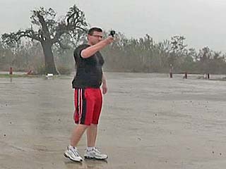
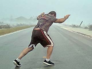
During the evening of October 9, the second half of hurricane Delta hits, and the calm eye moves away, giving way to winds gusting over 80 MPH once more, although with lighter rain. Here I am attempting to stand in the winds (with "painful" raindrops) just west of SR 27 north of Creole, LA. |
|
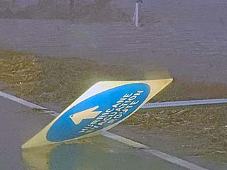
Downed sign along SR 27 while making our way towards Lake Charles after dark on October 9, while still being blasted by the weakening winds on the backside of hurricane Delta. Once inland, surge and wind damage gave way to severe inland flooding. We eventually made it to I-10, heading west to Baytown to pick up Derek's vehicle, and eventually out of the storm and to Houston. |
|
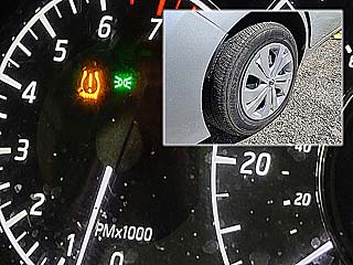
After driving through the hurricane, we woke up to a flat tire (inset) on October 10, 2020, with (thankfully) a slow leak that was taken care of with a can of Fix-a-Flat Derek was kind enough to have. The "TPS light" is not something you want to see when you are hurricane chasing, but beats the road hazard encountered after hurricane Laura in late August! |
|
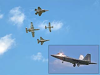
October 10 was a clear and sunny day in Houston, owing to a large area of fair weather well behind a hurricane as it departs. I was happy to enjoy an airshow at the Air Force base southeast of Houston, TX. The four planes in formation are (clockwise from left) an A-10 "Warthog", F-22 "Raptor", P-51 "Mustang", and an F-16 "Falcon". An F-35 in the landing configuration is in the lower-right inset. |
HTML File "delta20.htm" - Developed By Chris Collura
To Return To The HOME Page Of This Site Click The "INDEX.HTM" Link Here!